

A big gap in the north Portland bike network will be closed by this summer.
At last night’s Bicycle Advisory Committee meeting, Portland Bureau of Transportation staff revealed details of a project that will re-stripe about 0.4 miles of North Whitaker Road between the Columbia Slough (Schmeer Road) and Delta Park (Denver Ave/I-5). This stretch of Whitaker provides a crucial connection between north Portland neighborhoods and the Hayden Meadows shopping center (Lowe’s, Dick’s, Dollar Tree, Walmart, etc…), Delta Park athletic fields, Marine Drive, Vancouver, and more.
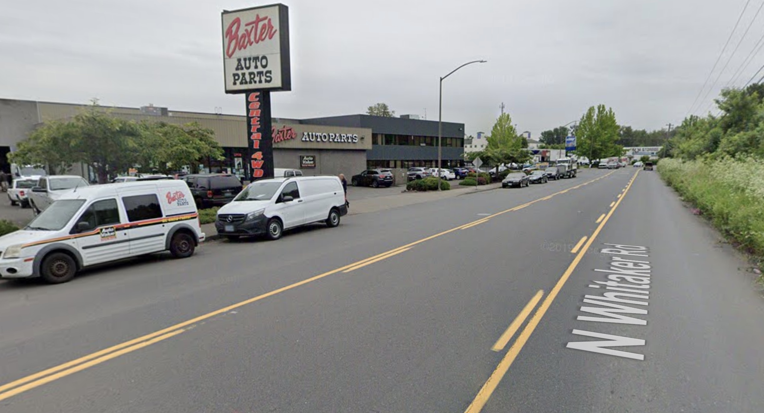
Currently it has no bike lane and wide general purpose lane which creates very stressful conditions for non-drivers.
Project Manager Zef Wagner said it started as a Rose Lane Project to speed up the Line 6 TriMet bus.
Advertisement
“Most of the time this will feel like an 11-foot bike lane.”
— Zef Wagner, PBOT project manager describing the shared bus/bike lane
“We were just going to do a northbound bus lane from [North] Hayden Meadows Drive up to the I-5 on ramp, and then we looked at the volumes of bike traffic that’s already there, and thought about its role in our bike network and we decided to make it a combined bike and bus project,” Wagner shared at last night’s meeting.
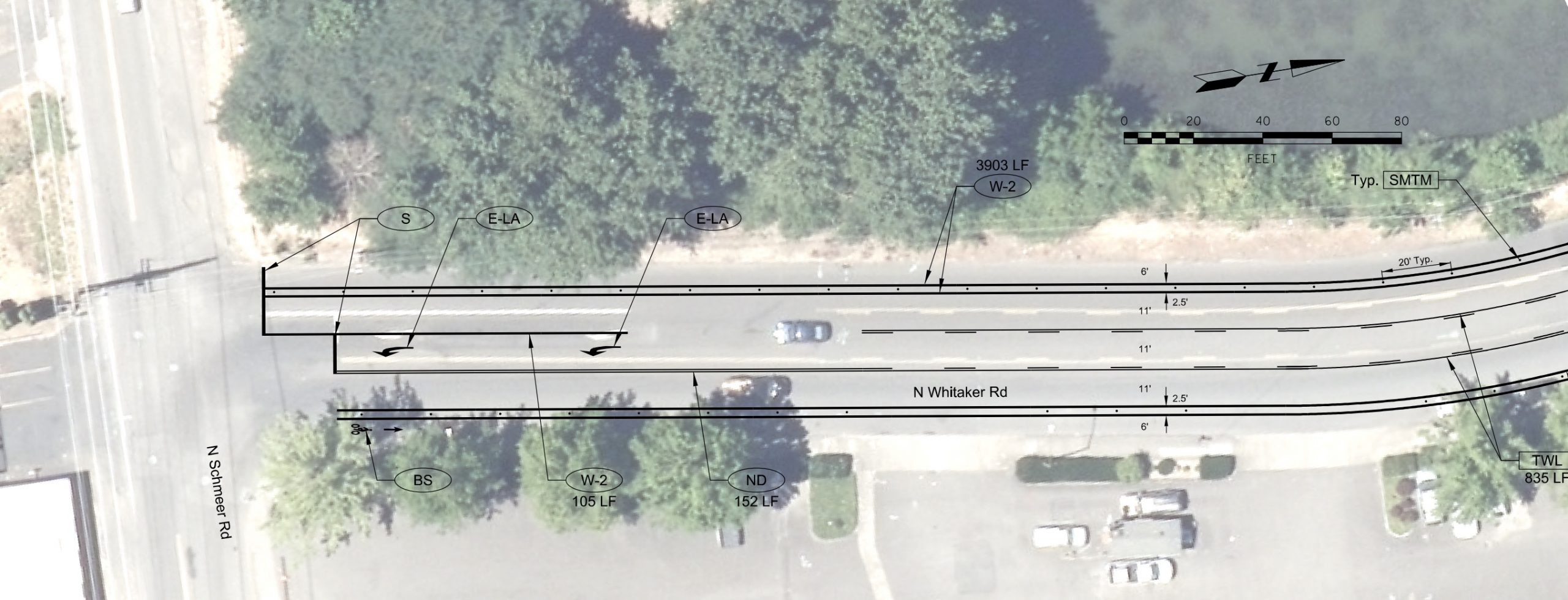
Northbound, the design will trade the on-street parking lane between Schmeer and Hayden Meadows Dr (shopping center entrance) for an eight-and-a-half foot buffered bike lane (six feet plus a two-and-a-half foot buffer zone) that will come with protection via plastic vertical delineators. North of Hayden Meadows Dr, the facility will transition into an 11-foot wide shared bus/bike lane for a short distance to the Delta Park entrance.
Southbound the protected and buffered bike lane will be continuous from the Delta Park exit to Schmeer Road (there are no intersections or driveways in the southbound direction).
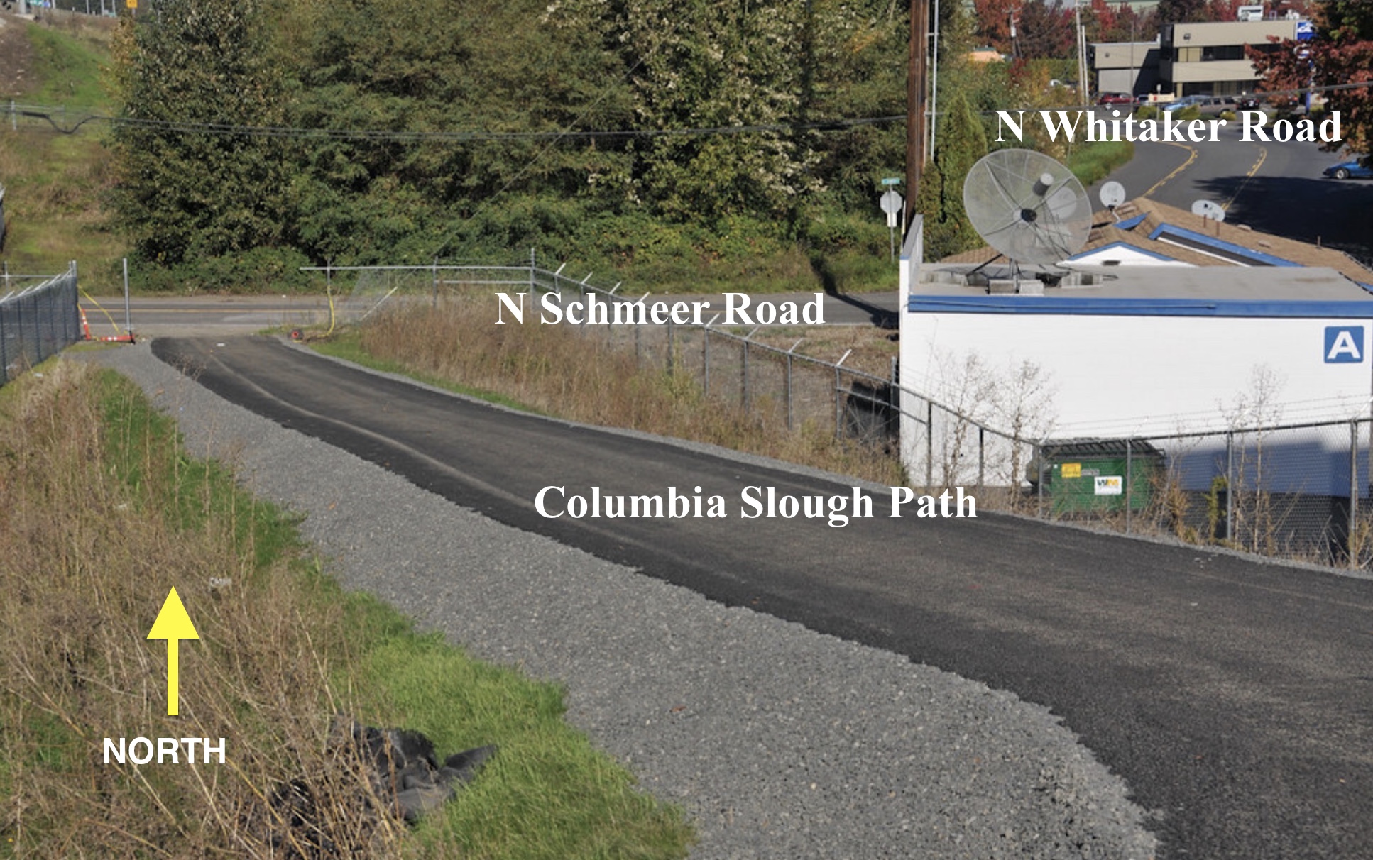
Below are a few more existing conditions shots, followed by PBOT plan drawings:
(Photo: Jonathan Maus/BikePortland)


Wagner fielded some concerns from the BAC about the northbound shared bus/bike lane. But he explained that due to “space constraints” PBOT had to make a compromise. The two bus stops are rarely used, he said, “So most of the time this will feel like an 11-foot bike lane.” “And when there is a bus, there’s a small chance that you might have to wait behind the bus for a short time, but most of the time that won’t be an issue… I think this will be a huge improvement”

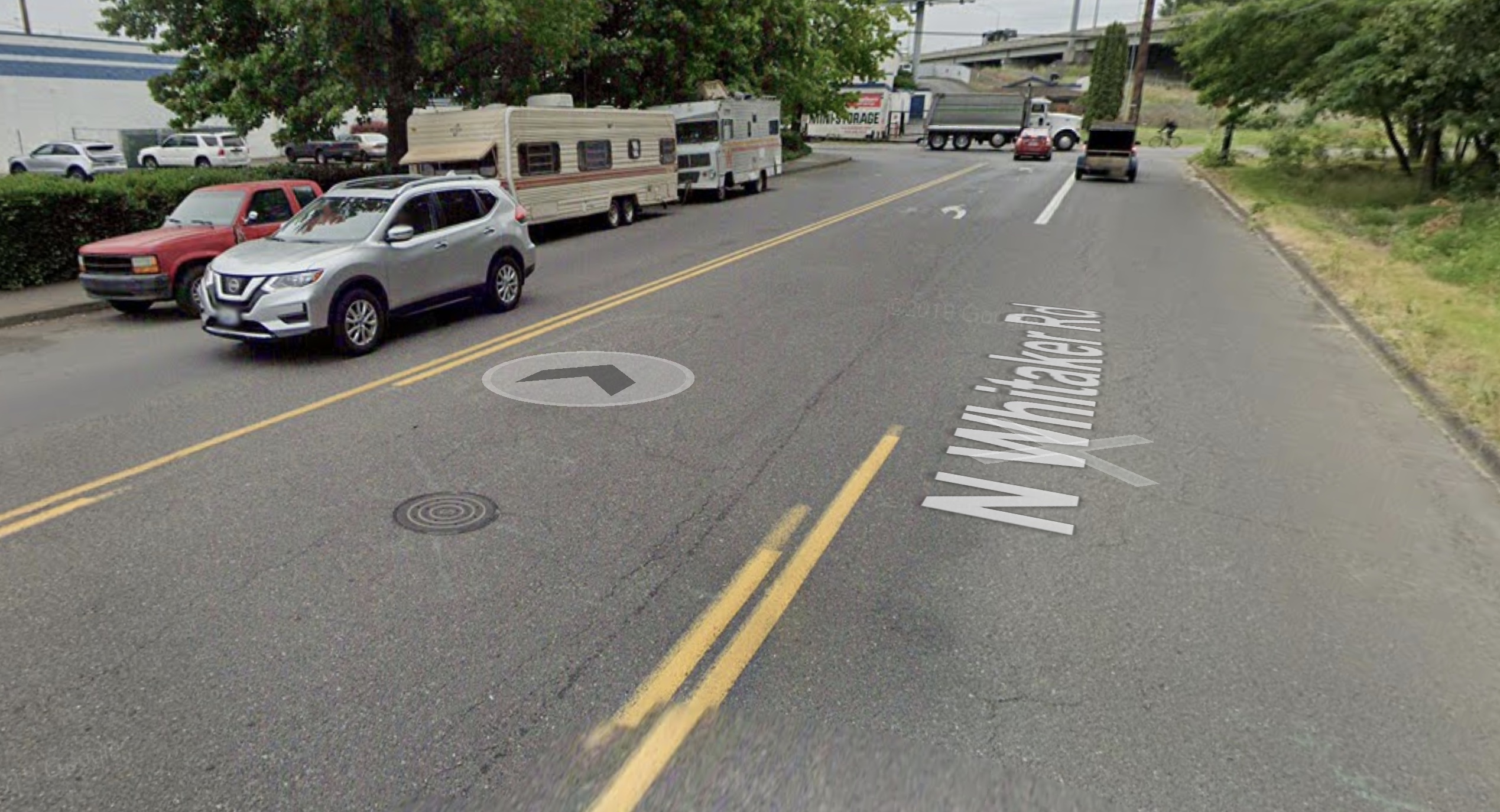
Another issue brought up by BAC members was the tricky cycling route southbound from of Delta Park/Denver onto Whitaker Road (above). This is a curved road next to freeway ramps (and those horrible ODOT wide-radius corners!) that can feel scary to bike riders. There’s also a median in the middle of the intersection with a small cut-through for bike riders. Wagner said PBOT would have preferred to rebuild the median to create more safety and space for riders to cross in that location, but doing so would have required sign-off from state traffic engineers (because of the proximity to Oregon Department of Transportation’s freeway).
“I think the whole corridor is gonna have more friction and visual annoyance for people, which also tends to slow down traffic.”
— Zef Wagner, PBOT
“Modifying the median itself would involve a lot more difficulties getting approval with ODOT than we were prepared to do in this phase of the project,” Wagner explained. “It would have required state traffic engineer approval which can be very difficult and time consuming.”
To help in the short-term, PBOT’s project will stripe a big “Do Not Block” box at the intersection. That should provide some refuge, and Wagner says is just a placeholder until the city can invest more. This project has a “pretty low budget”, he said. “Think of this as a ‘phase one’ that we can upgrade in the future.”
According to a PBOT spokesperson, the project budget is just $150,000. That includes $35,000 from TriMet.
Another bit of good news shared at last night’s meeting is that the Amazon distribution facility being planned nearby will come with a new traffic signal at Schmeer and Whitaker. Wagner said PBOT will take this opportunity to “create a seamless connection for bikes from Whitaker to the Columbia Slough Trail… There will be a little path connection there.”
Whitaker currently has 14-foot general purpose lanes next to eight feet of shoulder/parking area that is rarely used. It’s a design that encourages dangerous driving. PBOT will reduce those 14-foot lanes to 11-feet, and the addition of a buffered bike lane and/or bus lane will dramatically change the feeling of the road.
“I think the whole corridor is gonna have more friction and visual annoyance for people, which also tends to slow down traffic,” is how Wagner put it.
This is excellent news! This gap has been on my story list for years and I’ve been hoping that PBOT would address it.
The project is expected to be constructed this spring.
— Jonathan Maus: (503) 706-8804, @jonathan_maus on Twitter and jonathan@bikeportland.org
— Get our headlines delivered to your inbox.
— Support this independent community media outlet with a one-time contribution or monthly subscription.


")

Thanks for reading.
BikePortland has served this community with independent community journalism since 2005. We rely on subscriptions from readers like you to survive. Your financial support is vital in keeping this valuable resource alive and well.
Please subscribe today to strengthen and expand our work.
As a semi-regular user, I’m ambivalent.
In 2015, it was a missed opportunity.
In 2021, it feels like a homeless displacement project on behalf of Amazon.
I was more ambivalent when the shoulder space wasn’t being used for RV parking. Now I rarely encounter a day where I don’t have to take the lane to avoid it. This is why these bike lanes are needed now more than ever. There are plenty of other places in the area to park an RV.
I don’t ride over there often, but the last time I was in the general area (N. Vancouver north of Columbia) there were 3 semis and one tractor trailer attached to nothing parked in the bike lane in various spots.
Unprotected gutter lanes sure aren’t going to stop people from parking there.
This is good news! Seems like an ideal place for a two-way fully protected cycle track on the west side of Whitaker with zero cross traffic conflicts.
The southern connection to the slough path is offset and weird anyway. On the north end, continuing into Delta Park would be more difficult when going north, but is that better or worse than all the conflicts on the east side of Whitaker? I am not a traffic engineer…
I don’t want bike lanes to be used as an excuse to further displace and harass houseless people.
Perhaps they can stay in your yard then?
If that is part of a broader systemic solution, sure.
You don’t really mean that and you know it. However if you’d like to host a vulnerable citizen and show us how it’s done then be my guest.
They won’t be, so you don’t have to worry.
The left from Delta Park onto Whitaker might still be a tough one, but overall this is a hugely welcome change.
Off topic, but has there been any discussion about the use of the Columbia Slough Trail as an exit for cars from PIR after certain events? I attended a race there in 2019 and was quite surprised that they directed us to drive on the trail (under Interstate Ave) instead of simply exiting out of the main entrance.
As someone who appreciates our regions trails as one of the few car-free environments in our area for bikes and peds to enjoy. I don’t live near the Slough, but I know I’d be unhappy if they closed one of my local trails for the use of cars after an event.
The new configuration allows them to exit cars onto Interstate without crossing the Slough trail:
https://goo.gl/maps/T9vFtFbb4N19ce9o6
Looking at Google Earth and streetview, it looks like exit has been there for many years. That’s one of the reasons why I was surprised that they routed us on the trail when that exit was right there.
I’ve been hoping they would do something like this with all that extra road space for a while. I’ve rode through here several times, usually to go to Lowe’s, which has mediocre but better than Home Depot bike parking. I usually go from the slough path to Whitaker to Hayden Meadows so I don’t have much experience with Whitaker north of that. The improvements to the Schmeer intersection should also be nice to have. I’m guessing the plastic posts will be destroyed in short order at the right turn from Whitaker to Hayden Meadows. That space is currently treated like a right turn lane by most drivers.
This is GREAT news! I have cycled 100’s of time through this section to get to / from Portland over 20 years. I often wondered why this had not been done years earlier…given the abundance of off street parking near by and that adjoining businesses tended to illegally use the parking lane for product / equipment / fleet vehicle storage…
This is the last link needed for a decent route all the way from downtown Vancouver to downtown Portland.
Except — Schmeer Road still needs paved shoulders on the 60’ long segment from the Columbia Slough Trail to Whittaker. A very short dogleg, but very rough right now.
After this is completed I hope PBOT/ODOT will Mark this prominently as the preferred route from Portland to Vancouver:
* Steel Bridge to 1st Ave
* NE Multnomah to 3rd. Ave
* 3rd Ave/2nd Ave/Rodney Ave to Jessup
* Jessup to Vancouver/Williams
* Vancouver Ave to Columbia Slough Trail
* Columbia Slough Trail to Whittaker
* Whittaker to Delta Park
* Wind through the Marine Dr interchange, cross Portland Harbor on I-5
* Wind around the Jansen Beach interchange, cross the Columbia River.
100% All Ages and Abilities compatible.
Thanks PBOT!
Ted Buehler
Can’t say that I think of that mid-block crossing just past the blind corner of a freeway offramp as all ages. The alternatives aren’t great either. Whatever they do with the Interstate Bridge in the future, that connection has got to be much better.
IDK Ted. Seems like we could use a more direct route. What if Williams/Vancouver was actually made safe? It already has some of the highest bike counts in the city (which supports one of the best variables of safe design: safety in numbers), and only needs physical protection and signal separation.
Absolutely not all ages and abilities. The section between Delta Park and the actual I-5 bridge is confusing, dangerous, and requires many sections of out-of-direction travel.
Champs — the old CRC proposal didn’t make any changes south of Marine Drive. If we want improvements through Delta Park we need to ask PBOT
Chris I — what is unsafe about Delta Park to the river? It’s not the best, but it’s on separate pathways the whole way. And the old CRC proposal included plenty of out of direction travel, so that’s not going to change.
Re: left turn out of Delta Park southbound — not great, but it looks like they’re widening the median refuge.
Eawrist— Re: directness — 3rd Ave is only 3 blocks off Williams. You’re only going 3 blocks out of the way to get 3 miles of Neighborhood Greenway routing on Rodney versus the more direct route on Williams. Seems like a good trade off to me.
(Unrelated — Re: Vancouver/Williams — sure, it’s busy, but PBOT overestimates volumes by 20% due do a calculation glitch)
Thanks for the replies,
Ted Buehler
Great article. This is exciting news. My neighbor will be bike commuting from NE Portland to Vancouver starting this summer, plus I’m wanting to bike to Vancouver more and more. This is encouraging news!
Thank you to PBOT for pushing this project through. HUGE safety upgrade for people riding to and from Vancouver, and will reduce delays for both cyclists and bus riders.
Side note: for anyone who hasn’t ridden this corridor before, please be on the lookout for broken glass on N Denver.