
(Photos: Tina Ricks for BikePortland)
This article is by new Washington County contributor Tina Ricks.

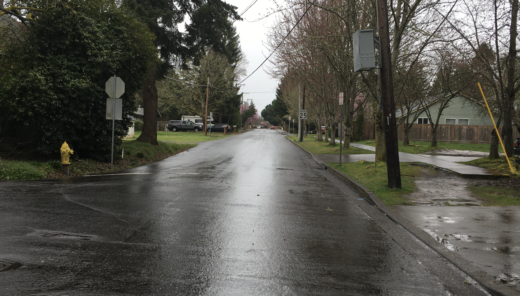
The City of Hillsboro and Washington County are planning a new road segment on Century Boulevard between Main Street and Lois Street. It will bring 8,600 cars a day through the middle of a quiet neighborhood and sensitive natural area next to Noble Woods Park. Washington County says the proposed road doesn’t go through the park. Technically, that’s correct. The new road would go next to the park, through what is currently designated as greenspace.
But beavers, muskrats, ducks, and birds don’t see property boundaries — they’ll see a three-lane noisy road through their home.
Advertisement

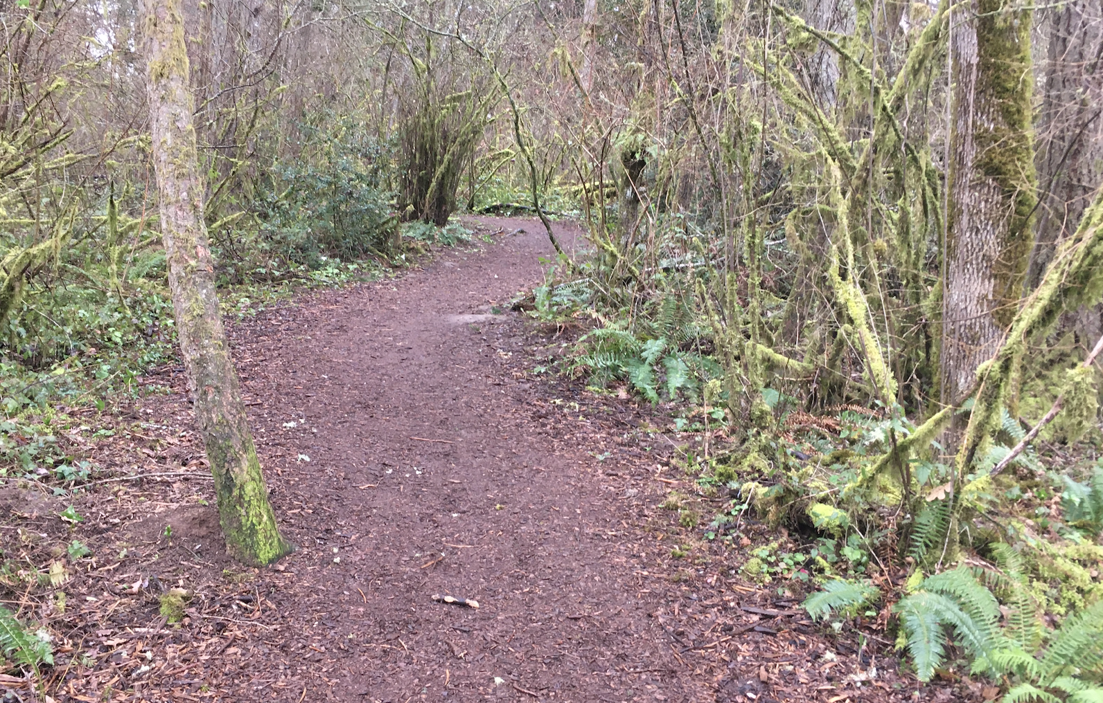
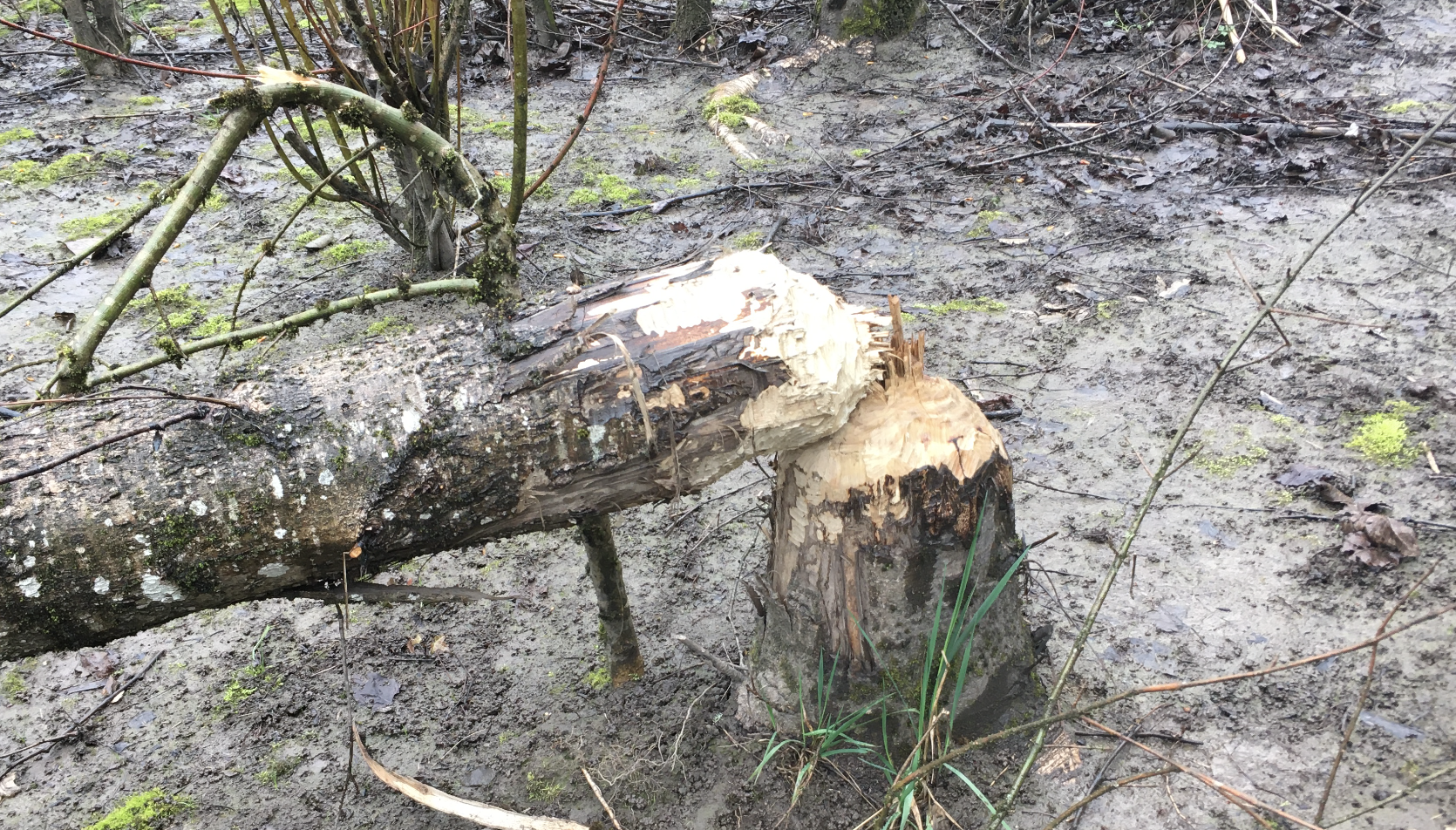
Noble Woods Park is forty acres of forest and wetland in the City of Hillsboro. In 1992, citizens made pledges, children saved pennies, and many other donations bought the land for the park and gifted it to the city. The park includes miles of trails; boardwalks for walking and viewing; and hosts birds, ducks, beavers, and other wildlife. Both the east and west sides of the park adjoin non-buildable wetland greenspace areas, following the courses of Beaverton Creek, Rock Creek and Dawson Creek — a continuous corridor of quiet and fresh air for human residents that provides habitat for animals.
The proposed new road would run along the eastern edge of the park, separating the park from the adjoining greenspace. A new bridge would go over Rock Creek. The north side of the park is East Main Street, a busy five-lane road. The proposed new road is a continuation of Century Boulevard through Hillsboro.
This project is one of Century Boulevard’s last unfinished segments. Once completed, it will be a major north-south connector across Hillsboro. In addition, the project would remove forty-seven trees from the greenspace next to Noble Woods. Currently, this stretch of Century Boulevard isn’t a boulevard at all, it’s a quiet, narrow neighborhood street.
Washington County’s online open house documents state:
“This project is identified in the Hillsboro Transportation System Plan as a priority to improve bicycle and pedestrian connections. We are building a sidewalk and raised cycle track the full length of the project, creating a new route between homes and businesses.”
Pedestrian and bicycle connectivity across the park is a problem, as the existing paths are narrow, winding, and some are unpaved. Currently, signs ask bicycle users to walk their vehicles through the park.
“If this road gets built, there will be a lot of new cut-through traffic. This is not a net benefit to the community.”
— Ben Fryback, neighborhood resident
The proposed cost for this road extension is $17.3 million. Washington County calls this an “improvement project”. But 8,600 cars a day through a residential neighborhood park call into question who this “improvement” is for. The added traffic will be noisy, dangerous, and not welcoming to wildlife and other vulnerable road users.
A different option would be a wide, multi-use, pedestrian and bicycle path along the route of the proposed new road, with a raised non-slip-surface bridge for bike riders and walkers over Rock Creek, Beaverton Creek, and wetland mud. A path plus a footbridge would connect pedestrians and cyclists from south to north, beginning at the corner of Borwick Street and Century Boulevard, and ending at the existing traffic signal (with sidewalks and bike lanes) at East Main Street and Century Boulevard.
Noble Woods Park is quite literally a gift to the City of Hillsboro. Just ask the donors, the Girls Scouts, and the schoolchildren who raised the money in 1992. While Washington County is not technically violating the park boundaries, they are violating the intent of the children and adult donors who made the park possible.
Ben Fryback grew up in this neighborhood, still lives near it, and commutes to work through it on his bicycle every day.
“There are kids playing and using these roads to get to school. It’s quiet. If this road gets built, there will be a lot of new cut-through traffic,” Fryback shared with me. “This is not a net benefit to the community.”
You can learn more about this project or leave a comment for Washington County Roads at the Century Boulevard Online Open House. You can learn more about other transportation projects in Hillsboro in the Hillsboro Transportation System Plan. The deadline for comments isApril 4th.
— Tina Ricks
— Get our headlines delivered to your inbox.
— Support this independent community media outlet with a one-time contribution or monthly subscription.


Thanks for reading.
BikePortland has served this community with independent community journalism since 2005. We rely on subscriptions from readers like you to survive. Your financial support is vital in keeping this valuable resource alive and well.
Please subscribe today to strengthen and expand our work.
I see our friends over in Hillsboro have learned a thing or two about greenwashing road expansions from ODOT and PBOT.
“We need to build this to make it easier to bike!”
I found this whole situation frustrating because I feel like the county’s documentation includes a lot of greenwashing language. Yes, it’s easier to bike, but oh by the way it also includes 8600 cars a day.
I strongly disagree with the opposition to this street myself. Connecting Century would fill a massive gap in the network and help to connect a grid system in the area. In my opinion, anything that increases the “gridness” of a road network in a city is a good thing, and looking at a map of the area there are currently no good connections for any mode between Corn Pass and Brookwood.
Building this connection would decrease traffic on all the other streets in the area since drivers wouldn’t have to go a long way out of their way to get to their destinations, and would increase connectivity for bikes, runners, and walkers as everyone south of the park would be able to more easily get to places north of the park. I’d rather, as a cyclist, not ride through the twisty trails in the area to get north-south, but would rather follow a straight road (with good bike/ped facilities) where I’m able to go fast to do so.
We currently are seeing the massive problems that a lack of grid connectivity in East Portland has made in the area in terms of safety and bike-friendliness. Let’s not make that mistake here; let’s take advantage of the opportunity to connect the grid.
Some people want SW Vermont Street to be punched through to the west of Oleson. That would increase flooding in Fanno Creek. A boardwalk is needed instead by those two schools on Vermont st. How will more pavement encourage more people to walk and ride a bike?
The article suggests a wide, straight, multi-use bike/pedestrian path and footbridge along the route of the proposed road, just to the east of the existing park boundary. That would increase connectivity for bikes, runners, and walkers. I agree that the twisty trails in the park are not intended for bicycles. Does grid connectivity have to include 8600 cars a day through a nature park and greenspace boundary? Calling this proposed road bike-friendliness, in my opinion, is greenwashing.
Would be interested in anything you’ve found that shaped your opinion regarding complete grid = better city scape.
I think this project is a great example of doing a little of everything so nothing turns out good. There will be no bike lanes on this road, only shared use sidewalk paths, which are not appropriate for fast cycling as it seems you prefer. Also this road will contain a rapid flash beacon for pedestrian crossing so undoubtedly the design team is anticipating poor driver habits and their annoyance with having to drive slow through a residential area.
A bike/ped bridge in this location would not only be a huge improvement to connecting the grid for modes that benefit the most from it AND be an additional draw to the area as a way for people to experience the park in a new way. This strikes me as a very similar opportunity to the path that goes around Tualatin Hills nature park on the NE corner.
Kulash, Walter M. Traditional Neighborhood Development : Will the Traffic Work? Presented at the Pedestrian Conference. Bellevue, Washington. October 1990.
Steutville, Robert. The Copious Capacity of Street Grids. Public Square, A CNU Journal. June 2018.
“Historic street grids have greater capacity to handle all kinds of traffic, including motor vehicles.”
As counter point, I content that the project will not so much reduce traffic on other routes, but increase traffic overall. Certainly it will increase traffic on this route. The claim that the project will improve the experience of runners, cyclists and walkers is conjecture based on your desire to “go fast”. Not everyone wants to go fast but if you do, there are lots of places to do that. Green spaces not so much. Places of shady green twisting paths are just the type of places that contemplative slow walkers might want to be. Green spaces, quite places and slow spaces are rare in the urban fabric and worth preserving. Oh, it is worth mentioning that east Portland’s interrupted grid system calms traffic in residential areas
I don’t think you finished that thought, Granpa, but I agree with you that any argument to build more capacity for motor vehicles always means … (wait for it) … more motor vehicles! At least a thousand studies have documented the deleterious effects of induced demand.
Build a road for motor vehicles, and they will come, in spades.
Build a multi-purpose path, and the cyclists, runners, walkers, boarders, kids on scooters etc will come.
It’s simply not the case that a wide road exclusively for motor vehicles is needed to reach any outcome we desire. Cars can always go around, and no one will even notice.
Never fails there is someone who is favor of destroying something beautiful in favor of more cars.
As a cyclist myself… no you don’t want to go to the trouble to finish a street grid for cars. Has nobody looked at what most cities in the Netherlands have done with their neighborhood street grids?
Making more room for cars never makes the car traffic more tolerable elsewhere.
A not insignificant part of this project not explicitly shown in this summary is a realignment of the road further south that will use additional green space to connect directly with SE Century south of Lois St. Over a quarter mile of small residential street south of the park cut through (sorry, “cut next-to”) will be drastically altered.
The addition of this as a major corridor is just blatant induction of vehicle use. The project website states that Brookwood and Cornelius Pass are encouraged corridors for NW travel… well, building a 3rd option here would seem to NOT be, in fact, “encouraging” that. The current distance between Brookwood and Cornelius Pass is the same as Cornelius pass to 185h, 185th to Murray, etc… The sprawl development of south Hillsboro should not be used to justify some engineers pet project like this.
This is tough, it’s a no win situation. There isn’t a great grid network of streets on the westside so those roads that do exist end up being big multi lane things. But if we try to create a better grid we end up with more traffic through our neighborhoods. More 3 lane streets or fewer 5 lane streets?
As a cyclist and resident of Hillsboro who lives within 3 miles of this project, I respectfully object to pretty much every assertion you make in this article. Primarily that this project would change Century Boulevard into something it was not intended to be (a main North-South route), when in fact it’s partly quiet residential aspect has been a result of the city waiting decades to actually initiate this project. I’ve heard talk of this connector since the 1990’s and it’s clearly shown in this Transportation System Plan from 2004 still online: https://www.hillsboro-oregon.gov/home/showpublisheddocument?id=1847
The road will only skirt the east edge of the park property, an area that is from my own experience visiting the site, not a pristine native habitat, but a disturbed area of old fill materials and dense non-native blackberry thickets. There are no official park pathways in this area, the first photo in the article is in fact a maintenance and power-line service road. I know as it’s the only part of the area I ride in because as you mention cyclists are asked to dismount on the actual park trails.
You call it a “cut through” but the plan is to actually REMOVE cars from cutting through residential neighborhood streets where children play as they do now on SE Borwick St. and speeding though the blind right angle turn right at the south park entrance for Noble Woods Park. The intent IS to make a straight connection for Century Blvd, and make that extension part of a city wide plan to route Century onto 3 lane, non-residential streets of current collector standard. Just south of the park, they even plan to turn existing residential Century into a dead end court so the residents there can gain a measure of peace from current traffic loads. This isn’t about inducing demand, but moving higher traffic loads to suitable roadways with proper active transportation features.
Given that Century Boulevard connects to the west edge of the MEGA South Hillsboro project, some proper road design to get traffic north to the freeway is basically a tsunami wall to prevent the future flood. Traffic is coming, no matter what. Apart from Cornelius Pass and Brookwood Roads it needs another non-residential route to build the grid and lessen the load on the system. This is not Portland. For better or worse this is a suburb and people are going to rely more on vehicles than is possible in a denser urban environment. While most large developments out here now try to have a village component where people can walk and bike to shopping and recreation, cross-town trips are a necessity and in fact the area is growing much faster that TriMet can even plan transit for. I know a lot of people who read this blog are absolutist anti-car advocates, but understand that outside the insular Portland bubble this isn’t the reality. Yes, Hillsboro residents like myself understand the need for the long term goal to be a reduction in overall vehicles and in shorter term reduction of ICE ones, but it is going to be a gradual one, and in the meantime pragmatic decisions need to be made to balance everyone’s needs. Something I believe the Century Boulevard connector achieves. It has my full support. Read the plan if you want to inform yourselves: https://www.co.washington.or.us/LUT/TransportationProjects/centuryblvdext.cfm
Where to start: First the “you” who wrote this piece was not Johnathan but woman local to this area along with contribution by a small group of other westside transpo cyclists. (but we’re the ones living in a bubble?)
The picture in the article is showing an area on google maps as “East Woodland Trail”… and of course it’s not an official park of the park, it is outside the parks property, what is your point? Anything not set in stone is fair game for pavement?
Confused about your entire point regarding the conversion of this a 3 lane non-residential corridor. You cannot cut a road through a residential area then just call it a non-residential street. Have you looked at the design? There are 13 driveway curb cuts in it. You can’t turn a residential area into a high traffic road then say, “look we reduced residential cut through traffic!”… no you just made it officially sanctioned residential traffic. Your last statement in that paragraph regarding the dead end of century is just laughable. That dead end is just the result of their sloppy design creating a weird cutoff of the existing road, not a “win” at all.
Strongly disagree regarding traffic from south Hillsboro using this to connect to Hwy26. A 3 lane collector should not be used for traveling 4 miles to Hwy 26 when Hwy 8 to 217 exists and the other actual NS arterials parallel it.
Maybe you’re the one that needs to get out of a bubble, Beaverton to Hillsboro is one of the areas I travel the most and I strongly oppose any increased road capacity.
1. Yeah, I understand how to read a byline. And I understood the guest writer to be a local. No part of my argument was that the writer themselves lived in the Portland urbanist bubble, but most of the readership/commenters here sure do. Sorry if I pigeonholed you, fellow readers.
2. Someone unofficially named it a trail on Google maps, so what. The point was the title of the article is “New road would cut through a quiet park in Hillsboro” When it’s actually “New road would replace gravel service road on periphery of quiet park” the whole title and premise of the article is a fallacy.
The potential for noise pollution bothers me a bit too. But the entire north edge of Noble Woods Park abuts Baseline Road so the environment is already not really that quiet other than the lowest parts along Rock Creek. With not only traffic noise, but the noise of aircraft on final approach to Hillsboro Airport directly overhead. Both the permanent structure and work schedule would have noise abatement as part of it. From the Environmental work section of the virtual open house:
3. The point is simple. This connector has been planned for decades. Longer than many of the actual residences built in the area have been there. No one who moved into the area in the last 30 years can say they didn’t know this was planned. This was always a planned collector corridor. It’s just now coming to fruition. Look at this 1999 TSP, page 32. There’s a green dotted line right there for this extension. Nothing is suddenly being rammed through. And it’s disingenuous to say that all the cars that will be taken off SE Borwick that currently route through that residential street isn’t reducing cut though. The total number of driveway cuts on residential streets bypassed by this project are probably 10x the number that will remain.
4. There is some accuracy in that point Brad. Eventually Century will be extended over 26 on an overpass near Hillsboro stadium, but will not have on/offramps due to proximity to CP and Shute Rd. So people could not use Century to directly access the freeway. The more logical point is through traffic to the freeway would Use Cornelius Pass or Brookwood/Shute and north-south local traffic between South Hillsboro and Orenco/Ronler Acres area could use this connector as an alternative.
5. I closely follow pretty much any new development in Hillsboro, especially as pertains to improvements to active transpo. Rather than not understanding reality, I have a pretty clear vision of what Hillsboro in one or two decades is going to look like, and see myself as a stakeholder in that future, one that I hope does have less low occupant vehicles, and more walking/riding/transit.
But As Bikeninja presciently pointed out. This project essentially a done deal. If there were any true environmental/livability negative impacts, 30 years of planning would not have progressed to the 1 year before break-ground point. I actually do feel bad giving another cycling advocate a bit of a shrug over this project and hope in a couple years you find it of value. But… shrug.
In paragraph 3 I forgot the link to the 1999 TSP. If anyone is really that interested, or just digs late 90’s graphics design styles and typography, here it is. Again, page 32 green dotted line just to the right (south) of the end of 231st (which is now named Century) at the blue line which is Baseline Rd. https://www.hillsboro-oregon.gov/home/showpublisheddocument?id=2098
Oh, and I counted driveways. Currently routing around this gap on Century and Borwick Streets passes approx. 56 residential driveways, not counting a bunch of small cul de sac streets with additional residences. After the project Borwick will be entirely bypassed and the number of driveways large traffic volumes will still pass will be reduced to 12, and that section will maintain a 20 or 25mph speed limit.
I do get that this has been planned a long time. And call it what you will… parkland, greenspace, utility road, whatever, it’s QUIET in that park right now. Adding 8600 cars a day along the side of the official park boundary will make it considerably less quiet. The park is a gift, literally and figuratively. Running a major road along the side of it, regardless of the style of bike lanes or sidewalks, destroys the peace of the park.
I get it too Tina, I really do. It is a beautiful mostly tranquil place, away from Baseline/Main at least. I’ve taken many family walks there when my child was smaller and I on a personal level will miss doing cyclocross hill repeats on that gravel service road/unofficial path (again, the only area I ride due to cycling prohibition on park paths). But 8,600+ car trips are coming to that neighborhood regardless if it’s straight through on a 3 lane collector Century or completely residential Century + Borwick.
I’ll take the noise and disturbance to ducks over a child being killed by the current rat run. And the improved quality and directness of the included bike/ped infra just tops it off in this specific case for me.
I genuinely appreciate the article though. Thank you. Any additional awareness of westside issues on BP is great. And while I push back against certain points you made on this project, I’m not trying to discourage you from continuing to guest write on local issues or sound like I am trying to marginalize your point of view. I respect it and was only trying to rebut what I feel are salient points. Cheers.
Why are 8600 more cars coming to that neighborhood? Are there plans for that substantial of housing density infill? If you are referring to South Hillsboro development then that is a fallacy, those 8600 cars will not magically drive on a road that doesn’t exist, they will use CP or Brookwood.
Strong Towns’ points on “No New Roads” shows the truth of it.
Yup, the “you” is in fact me, and I have lived Washington County for more than 25 years. I know this is not Portland. And I do disagree with the “traffic is coming, no matter what” premise. I know that the eastern end of the park boundary is currently a service road, and that the greenspace next to the park is not the same thing as the park itself. But the issue is quiet and connectivity with greenspace for fresh air and animals. This park, as it is today, is a gift to the people of Hillsboro, both literally and figuratively. It’s a rare oasis in the middle of a growing city. Running a major road right next to it would be a travesty for the quiet of the park. As an alternative, look at the Westside Trail that goes just to the edge of the THPRD Nature Park in Beaverton. It’s a wide, straight, paved trail for bikes and pedestrians, that allows bikes and pedestrians to get places fast (MAX stations and so on), and doesn’t interfere with the twisty, turny, some of them unpaved paths in the Nature Park. It also doesn’t add 8600 cars a day with pollution and engine noise.
Provide safe ways for people to get around without cars, and they will use them.
I’m not an absolutist anti-car advocate. I own a car and I drive regularly. I also bike, I walk, and I deeply appreciate urban and suburban wildlife. Having a place for wildlife to exist enriches us all. Running a road through the middle of a greenspace/park boundary, regardless of the current quality of the greenspace, is in my opinion not a great idea.
If the long-term goal is an overall reduction in vehicles, then why does this particular project, dividing a greenspace from a nature park, need to happen?
Transportation leadership has changed considerably in Washington County in the last few months. There is a new county executive and a new county commissioner in charge of transportation. This might provide opportunities to change this project.
I think this project has the whiff of inevitability about it. I believe cycling advocates would be better served to push to get world class cycling and walking facilities on the entire length of Century. New political leadership in Washington county should make this possible, and the prospect of an ultra-safe and convenient cycle route connecting the new South Hillsboro Development to the Orenco Station Max station should create a bullet proof argument. CWS will make sure Rock Creek,the beavers and the wetlands are well protected.
Yes, this. Though plans are already in the works for just that. All of the segments of Century that fall within the South Hillsboro plan area already are being built with separated infra. The upcoming TV Highway/Century intersection project will then add separated paths from TVH south to Davis. This would just leave the sections from TVH up to this project at Lois, and the section north of Baseline to Orenco to complete that full off-street connection to light rail. Another side benefit, is as part of this project, some preliminary work to extend the Rock Creek Trail from Orenco Woods Park to Rood Bridge Park is likely as its planned route passes right through this project area.
And yes, the Environmental Work page in the open house link in the main article actually details the scope of work they will do. Including with CWS on wetlands restoration and expansion, noise mitigation and even nocturnal animal sensitive street lighting that direct light just to the roadway and dims when no one is around.
I would like to see this proposed road become more like the Westside Trail segment that goes next to the THPRD Nature Park in Beaverton. It’s a wide, straight, paved multi-use trail that goes next to a nature park (filled with narrow, twisty, some unpaved walking trails). It means people who are just trying to get from A to B (such as shopping and MAX stations) can do it. It also doesn’t bring 8600 cars a day right next to a nature park and through an undeveloped greenspace. A safe and convenient cycle route does not have to include 8600 cars a day.
Build it already….it was needed 10 years ago. Delaying it only makes things worse!
This analysis ignores the fact that there is already cut through traffic in the neighborhood. Cars fly down Borwick street to reach Main/Baseline. Borwick is largely devoid of sidewalks making it challenging to reach Noble Woods in a safe manner. Other East/West streets have similar impacts. Once you add the 20,000 residents of south hillsboro, the impacts will be compounded, especially since the cornelius pass and tv highway intersection cannot handle close to the current volume.
Exactly. nearly everyone arguing against this project totally ignores that it will remove most cut-through traffic on 3/4 mile of residential SE Borwick. I’d actually like to see the light at Borwick and Baseline removed or better yet turned into a bike/ped only diverter. There’s your new active transpo only connector. Turn traffic on residential Borwick into traffic on collector Century and leave an alternate quiet street for residents and cyclists.
Beavers, muskrats, ducks, and birds need to get with it and join the clowns and village idiots currently on the local transportation planning board, otherwise they risk getting chased by the fast runners, e-bikers and bicyclists passing through, or even becoming crash roadkill/flattened fauna.
Looks like there’s a 2 mile stretch of Baseline here between Brookwood road and Corenlius road without a north/south cross street. Two miles in Portland is about the distance from the Willamette to Cesar Chavez where there are 39 cross streets. Makes sense to build up a grid if you can.
This area is already a car-centric hellscape. Is one more road with speeding, inattentive drivers really going to make a difference?
If near 9,000 autos will use it daily it must be needed!
Thanks for the link to comment on this project. I strongly support it and was able to tell them that thanks to your link. As the South Hillsboro area builds out Cornelius Pass is going to become complete unpassable at rush hour. It already was prior to Covid and is getting worse again. The sooner the better for the Century extension as far as I’m concerned.
Unpassable due to crashes or car-centric planning?
LOL – love your apparent inadvertent use of “unpassable” (I think you mean “impassible,” which means “can’t get through). But “unpassable” is a great description of any road where impatient drivers don’t get to leave drivers doing the speed limit in their dust. You don’t have to worry about that in Hillsboro b/c most of your roads are at least four lanes so drivers can always pass.
“Unpassable” = traffic congestion that causes a few minutes of delay, apparently.
LOL in typical Hillsboro/WashCo fashion, they’re spending millions on some new or wider road and putting in zero new sidewalks on existing roads.
Oh wait, what’s that? They’re putting in sidewalks on Borwick and Ariel sidestreets? Yeah, nah. They’re only doing it in front of a lucky 1-2 houses beside the widened Century [1].
Yeah Hillsboro & WashCo give exactly two ****s about getting people walking or biking. This is a project driven by traffic engineers who love to engineer more and more traffic. There are a few great planners on staff (you know who you are) but there are some crusty old engineer dudes (they’re almost all dudes, I know them) who think the “traffic model” that predicts traffic in 20 years time is omniscient and infallible (even when their models have been proven wrong e.g. [2]).
1:
https://viewer.autodesk.com/id/dXJuOmFkc2sub2JqZWN0czpvcy5vYmplY3Q6YTM2MHZpZXdlci90MTYxNTU3ODk3NzY4MF9lYzRhZWQyNS01ZGRmLTQwNzAtOTc5My1iODdjMGRkODJmNTdfMTYxNTU3ODk3ODE0NC5kd2c?sheetId=ZGRjNTRjNzMtMTFlZS02MzdjLWU0NTEtN2RmMWNiNDUxZDZi
2: https://bikeportland.org/2013/11/15/priority-check-washington-county-will-spend-21-million-highway-improvement-project-97184
If what you’ve always had is a hammer, everything looks like a nail. I’d really like to see this be more like the Westside Trail segment that is just next to the THPRD Nature Park in Beaverton. It’s a wide, flat, paved, multi-use trail that is for getting from point A to point B, such as MAX stations and shopping. It’s next to the nature park (full of twisty, turny walking trails, some unpaved). It gets pedestrians and cyclists around, and it doesn’t bring 8600 cars next to a nature park.
In today’s complex construction environment, Building Information Modeling (BIM) has emerged as a transformative tool that reshapes how projects are designed, constructed, and managed. At its core, BIM is a digital representation of the physical and functional characteristics of a facility. It enables collaboration among architects, engineers, contractors, and stakeholders throughout the lifecycle of a project. But beyond its technological appeal, the real value of BIM lies in its ability to solve longstanding industry problems, chief among them: cost overruns, project delays, rework, and inefficiency. for more info about BIM and construction visit this website.
FYI-If you read the signage at the park closely bikes aren’t even allowed in the park. I had a somewhat tense “conversation” with a walker a few years ago after cutting through that park for a couple years on my commute. After inspecting the signage closely though the walker was right. Bike riding on the trails isn’t allowed now.
Agreed! The current park wasn’t built for bikes. The trails are narrow, winding, and many are unpaved. What I proposed in the article is very similar to the current segment of the Westside Trail that runs alongside the THPRD Nature Park in Beaverton. That park also has narrow, winding trails, some of which are unpaved, that really isn’t suited for bikes at all. The Westside Trail, by contrast, is wide, flat, paved, and straight. It runs along the park boundary. It’s for cyclists and walkers who want to get from A to B quickly, such as MAX stations and shopping. This trail segment also doesn’t bring 8600 cars a day right next to the park boundary.
While I don’t want to see additional cut-thru traffic in the neighborhoods south of this park, I do see how a new road is needed in this location for bikes and transit. Currently the Trimet 47 bus goes south on Century Blvd and turns west on Main St right before this new connection. Building a paved road here would allow bus service to be extended all the way south to Rosedale Parks and South Hillsboro. https://www.openstreetmap.org/#map=16/45.5179/-122.9155&layers=T How about making the new road segment accessible for buses, bikes and emergency vehicle only?
A bike, walking, emergency, and transit-only road would be amazing.
Thank you for writing about this! Century blvd will never be the successful big rush the city wants it to be because of the bottleneck at the MAX tracks. This is aboondoggle meant to placate the builders of homes for 30,000 more people in south Hillsboro. It will destroy there quiet of Noble Woods, it will ruin the quiet and safety for residents south of the park, and it’s a huge waste of OUR taxpayer money. I’ve written to the city about it, I’ve gone to open houses to complain, and the city didn’t care. I pray you can raise enough fuss to make them change their plans!
They want a road? Okay, a tree lined bike and pedestrian road. Quieter, cleaner, and much more in line with climate and sustainability, unless of course we just don’t care about these things anymore. While we’ve continued to hem and haw about climate change, suburbs continue to create more carbon emissions per capita, and it’s only been getting worse.