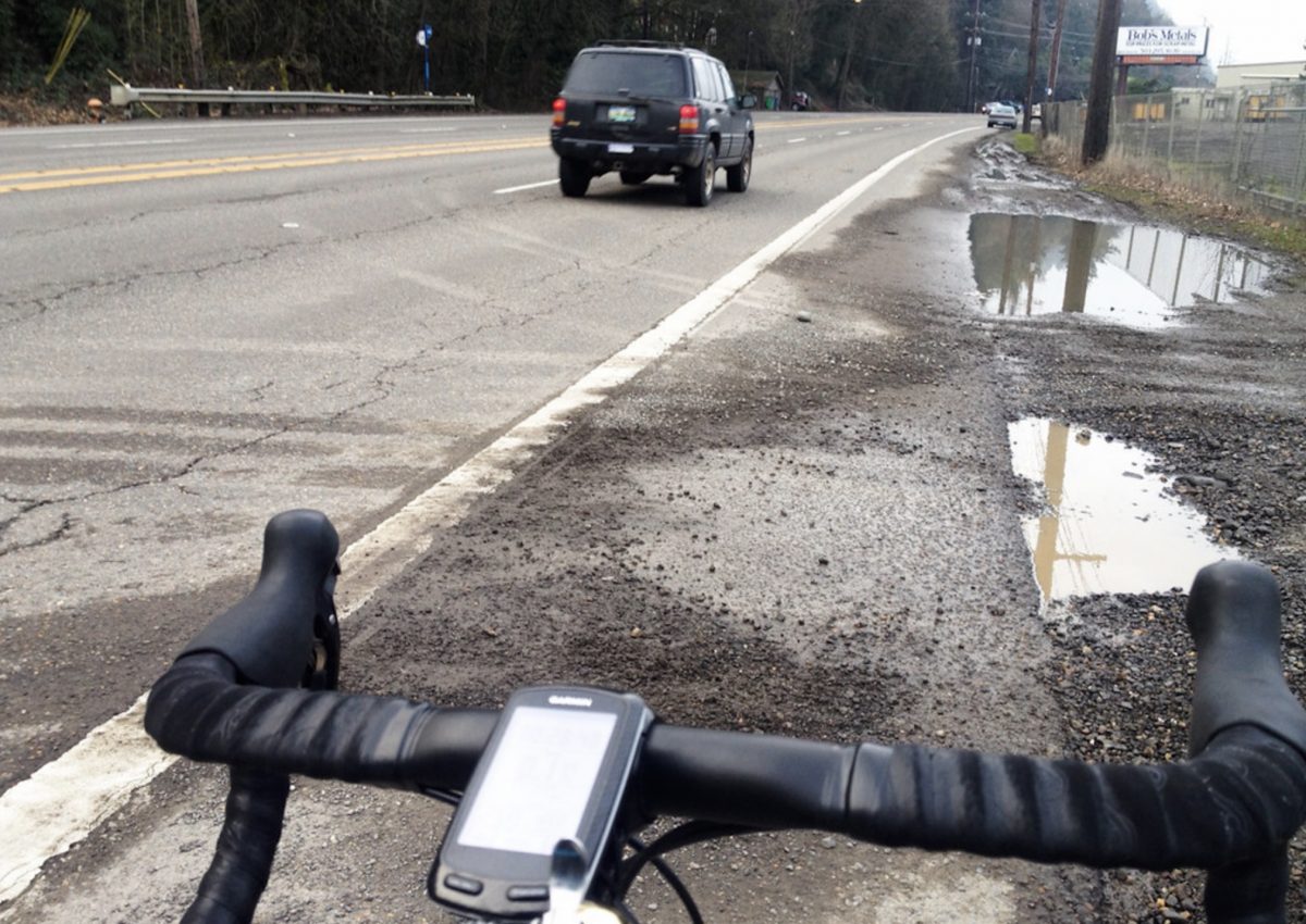
(Photos: Jonathan Maus/BikePortland)
Thanks to outside pressure, the Oregon Department of Transportation (ODOT) now says a major repaving project on U.S. Highway 30 will include several elements that should lead to better cycling conditions.
“Our design team is working now to find creative ways to improve the roadway for people using bikes.”
— Ellen Sweeney, ODOT
As we shared back in February 2019, ODOT’s $8.5 million U.S. 30 NW Industrial Area Repavement Project will impact a key, 2.5 mile section of what local riders call “Dirty 30” — from the St. Johns Bridge to NW Saltzman Road (and perhaps further south to Kittridge depending on budget).
Hwy 30 is a very popular route for cycling because it’s the only direct and flat connection from northwest Portland to St. Johns, Sauvie Island, and all the great cycling roads in the West Hills and beyond. Unfortunately it also has very fast (50+ mph) auto and truck traffic, and the bike lane conditions are usually always terrible (hence its nickname). The lane is unprotected and narrow and often strewn with gravel and other debris. Dirty 30 has probably caused more flats than any roadway in the region.
When we wrote about this project in 2019 we wondered if ODOT would do something to address the terrible cycling conditions. In 2016 ODOT did a similar project north of the St. Johns Bridge and squandered an opportunity to make significant cycling upgrades. Fortunately, since our story ran last year we’ve heard that local advocate (and BikePortland contributor/supporter) Scott Kocher and staff from The Street Trust have also been pressuring ODOT to do more for bikes in this project.
Advertisement
Asked for an update earlier this month, ODOT Region 1 Community Affairs Coordinator Ellen Sweeney said that while it was initially planned to be “a simple repavement project”, ODOT is now, “Working to find creative ways to improve the roadway for people using bikes.”
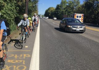
To that end, Sweeney said they have three cycling-specific project elements in mind that should improve conditions: 6-foot bike lanes with a 1-foot buffer (except for a few pinch points); improved drainage to avoid water pooling problems; and more paving on driveway approaches to decrease the amount/likelihood of gravel reaching the bike lane.
The wider and buffered bike lanes are a welcome change, although Sweeney acknowledges there will be “a few” pinch-points where they’ll narrow to just 5 feet. “But there are other areas where the bike lanes will be wider than 6 feet,” she added. “Additional space in the shoulder will be included in the bike lane.”
As for water drainage, Sweeney said,
“We’ve heard from people using bikes about their experiences with pooling water on US 30, especially near Doane Lake. While no drainage work was originally included in the scope for this project, our maintenance team and our hydraulic engineers are working together to identify opportunities for a short term improvement (to be implemented with this project) and a long term fix (with the intention of including it in a future project).”
ODOT is still finishing final design of the project and we should know more by this coming winter. Construction of the project is expected to begin in Spring 2022.
This is a very important project and we’ll be watching it closely. Stay tuned for more opportunities to share your feedback.
— Jonathan Maus: (503) 706-8804, @jonathan_maus on Twitter and jonathan@bikeportland.org
— Get our headlines delivered to your inbox.
— Support this independent community media outlet with a one-time contribution or monthly subscription.


Thanks for reading.
BikePortland has served this community with independent community journalism since 2005. We rely on subscriptions from readers like you to survive. Your financial support is vital in keeping this valuable resource alive and well.
Please subscribe today to strengthen and expand our work.
This seems like almost the perfect place for a Greeley style treatment, two-way cycling traffic on the west side of Hwy 30 to Bridge Ave.
ODOT prefers to stick cyclists onto breakdown shoulders. If they installed jersey barriers to protect the inside 10ft of the roadway, they would either need to forgo breakdown shoulders or reduce the numbers of lanes. Both of those things would mildly inconvenience motorists, so here we are…
Uh, I don’t want barriers and I don’t want “cyclists” coming at me either. Barriers would add quite a challenge to make left turns onto Logie Trail and the like. Gee, how about simple keeping it clean.
If you call ODOT about debris, they will tell you that shoulders without curbs are “self-cleaning”. This is the answer I always got when calling about outer Sandy Blvd.
That’s what I say about my kitchen, but it doesn’t make it true.
Do you want families and 95% of people who bike and walk only under physically separated conditions to be able to ride here?
GOD NO – I have nightmares about walled off two way solutions. The two up cyclists that won’t move over as you approach, the staggering amount of debris that pile up in the bike lane (two way Near Pier Park) – uuuugh. Give me some extra shoulder and fresh rumble strips.
It has always felt for me that US 30 could use a treatment similar to what was done on Greeley or even what was done for the SE 17th bike path connecting the Springwater & Trolley Trail. With cars and BIG trucks going 50+, and a lot of bike traffic from St. Johns Bridge all the way past Sauvie Island Bridge to Rocky Point, it would be amazing to have this revamp be more than just a re-paint. There’s more than sufficient pavement real estate for such.
This is such good news. None of us expect much from ODOT, but sometimes with enough of a push they will do the right thing. Even these modest improvements should help a lot with riding this section of Hwy 30. I’ve found the section north of St Johns Bridge to be pretty good, but this section to the south is the most “dirty 30” part and I usually try to avoid it.
Delighted to hear about the driveway paving, the gravel on the shoulder as you head towards the St Johns Bridge from town is a long-standing annoyance.
I agree the gravel on the shoulder is a long standing annoyance. While a wider shoulder will help a lot, I wish the owners of the businesses would take it upon themselves, or somehow be compelled to deal with the gravel build up created by vehicles entering and exiting their property.
Isn’t it interesting that, when there are “pinch points” in a roadway, it is the *bike* lane that is narrowed? I mean, there’s really no other choice, I guess.
I’m sure this is a big concession in ODOT’s mind, but none of those improvements are going to make me feel remotely safe with cars and trucks whizzing by at 50+ MPH. In most of this project area, they could probably get away with making it a 3-lane auto section with actual physically separated bike lanes and not impact auto congestion much. That would make things better for pedestrians crossing in Lintton, slow down speeds, and create a real option for people to get to Sauvie Island on bike.
I mean, I get your point, but at least there’s a 6-ish foot bike lane. It’s Sauvie Island that really creeps me out…
Agree, I’ve been riding the shoulder of Hwy 30 to do training intervals (as recently as last night.) The shoulder north of the St Johns Bridge is fairly wide and actually not that dirty at the moment. Sadly this makes for a less stressful experience (even with the occasional scary large tractor trailer) than the tailgating and close passes from annoyed Sauvie Island drivers. Def agree that the section between NW and the Sauvie Island is the more stressful and dirty stretch.
i got excited and then saw it is just a repaint job
so, no thank you.
will remain a non-user of this highway
Exciting. I’m a female rider, rode once out to Sauvie Island along Highway 30 and reluctantly said never again from all the debris, narrow shoulders and fast-moving traffic. If ODOT improves the cycling infrastructure, people will enthusiastically come out on their bikes to use it!!
I agree with the assessment of Hwy 30 and don’t find it enjoyable to ride, but I think the resources would be better used towards projects more like the one on SE 136th.
The reality is that the fundamental use case for these upgrades is to improve recreational riding conditions for disproportionately stronger and privileged riders. Whether you’re headed to Saltzman, down towards St Helens for a number of climbs, or Sauvie Island, you’re headed for longer distances on shoulderless roads with plenty of curves and traffic that moves right along even if it’s not as fast as Hwy 30. Anyone who can handle what Hwy 30 connects to can handle Hwy 30.
I will personally appreciate improvements that make accessing my favorite roads more pleasant, but I think making recreational trips more pleasant for those who’d be out there anyway should be considered low priority compared to providing alternatives to cars where trips must be made.
In this case we can do both. ODOT manages Hwy 30 while PBOT is responsible for 136th so we aren’t doing one at the expense of another.
Hi, St Johns exists, too. Some of us aren’t recreating.
I think things may be changing. I saw a woman on a cargo bike riding Hwy 30 a couple weekends ago, perhaps to get groceries on the island. This Summer I have seen more and more cyclists on regular old bicycles on hwy 30.
While I agree this is geared towards recreational cyclists and I would prioritize more people on bikes, it’s not a question of being able to “handle it”, it’s a question of being hit by a car, which I can’t handle and I am guessing neither can you. Characterizing it the way you do actually puts all the responsibility on the cyclist and not on the infrastructure or drivers.
As a person who lived in Linnton, who currently lives in North Portland and have commuted hwy 30 on a daily basis, I would also say that there are a number of people that do commute out there and there could be more if the route wasn’t so horrible.
This is a chicken and egg thing. If we had a world-class bike facility between downtown and the St. John’s Bridge, along with a safe crossing on the bridge itself, we’d probably see significantly more “utility” riders. As it is now, this section is primarily used by recreational riders during off-hours (morning on the weekend, generally) because the conditions are horrible. I only ride this section for recreational, and I would never do it on a weekday after 8am.
There probably would be a few more, but not many.
I stand by my assessment that the benefit disproportionately goes to a group that needs it less than others at relatively high cost for that benefit.
Despite the high speeds and this being a popular cycling route, it’s not particularly dangerous though cyclists not wanting to cross with signals (probably most, including myself) need to be mindful. Sightlines are good for motorists and cyclists alike, and there’s a lot of space to work with.
don’t you think more folks who live in st. johns and work downtown would use hwy 30 if there was better bike infrastructure? i sure would! but daytime commutes are even worse than riding to saltzman or sauvie island for recreation.
I agree with your observation about commutes.
You’d undoubtedly get a small but noticeable number more. But even with better infrastructure, it’s still a route for a more dedicated type of rider because weather, distance, noise, etc will always be issues.
For those who really hate Hwy 30, it’s only about a mile further from St John’s via Willamette to most downtown destinations (i.e. in the same distance category). The differential is greater for those who live on Hwy 30, but even then it’s not huge. So this isn’t a game changer no matter how you look at it.
I’m now reading all BP blog posts with one eye on the possibility of “uncritical cheerleading.” Seems as though the ODOT posts use much more neutral and skeptical language, like “This is a very important project and we’ll be watching it closely.” But recent posts about a painted bike lane in WashCo and the 4th Ave project in downtown Portland were described by words like “exciting.” Makes me wonder if there’s some unconscious bias in favor of more local project sponsors, like PBOT or its analogous agency in WashCo, while ODOT, which is based in Salem and socially distanced in the best of circumstances, is viewed more negatively.
Don’t get me wrong – ODOT has a terrible record of supporting cycling and deserves all of the skepticism it has earned. But I’d like to see projects viewed thru more of an impartial lens, based on criteria like:
– Whom does the project primarily benefit?
– Does it speed up or slow down cyclists?
– Does it speed up MV traffic at the expense of cyclists?
– Every project is supposed to promote safety, but how does this one further that goal specifically and what’s the safety record of these kinds of projects?
You’re doing some of these things, JM, and I’d never want you to lose your valuable perspective and the personality you bring to your posts. But even if we don’t like ODOT, we can judge the improvements they sponsor according to criteria we all agree on. Thanks.
ODOT’s mandate should be to create protected MUPs on along all urban and suburban hiways. Hwy 30 would be a fantastic start.
So, it’s been two and a half years and I know they’ve doubled the budget for the interstate bridge noone seems to want. Did they ever produce a plan for this?