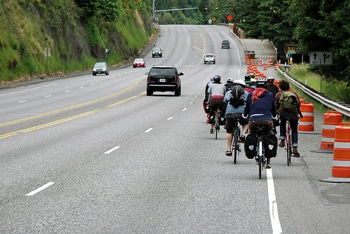
(Photos: J. Maus/BikePortland)
The Oregon Department of Transportation is about to finalize plans for a paving project on Highway 30 north of St. Johns. The project is a golden opportunity to improve this key bikeway corridor that connects Portland to the West Hills, Linnton, Sauvie Island, Scappoose, and beyond.
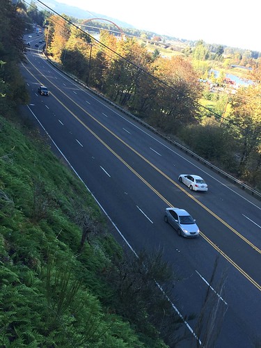
Highway 30 is a crucial connection from Portland to points north because it’s the only paved street between the steep West Hills and the Willamette River. Unfortunately the riding conditions are bad and often downright dangerous. The road is known as “Dirty 30” in cycling circles because of its poorly maintained bike lanes and shoulders that are often filled with debris. Flats on the road are common. Making matters worse is there’s not enough separation between the bikeway and fast-moving car and truck traffic.
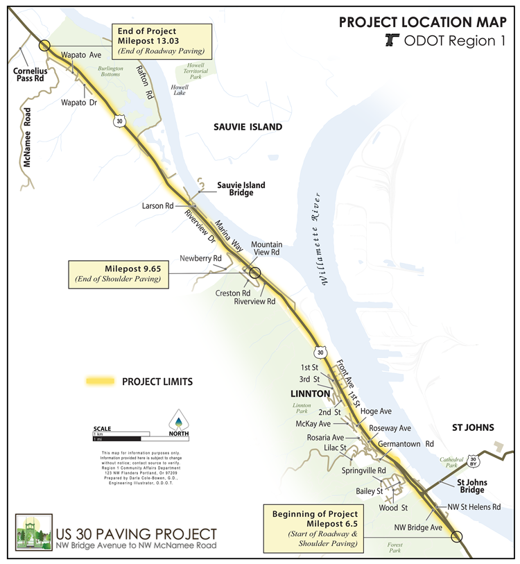
This summer ODOT plans to repave seven miles of this road from (just south of) the St. Johns Bridge to (just south of) Cornelius Pass Road. From mile marker 6.5 (south of the bridge) they’ll repave the entire road from curb-to-curb. Then from mile marker 9.6 (Creston Road) to mile 13.0 (McNamee Road) they’ll repave just the roadway and not the shoulder. Below is detailed map of the project:
Last April I sat down with ODOT Region 1 spokesman Don Hamilton and bicycle/pedestrian coordinator Basil Christopher to learn more about the project and make sure they understood how important Highway 30 is to bicycle riders. I laid out a host of suggestions and ideas on how they could use this project as a catalyst for improving cycling conditions. Almost a year after that meeting, ODOT says the project will do several things to make life better for bicycle riders.
This project will standardize and widen shoulder and bike lane widths (I differentiate between shoulder and bike lane because north of Linnton the bike lane technically ends and it becomes a shoulder). The road currently has two standard lanes in each direction in addition to the bike lane/shoulder. After this project the inside lane will be 11 feet wide and the outside lane will be 12-feet wide (ODOT says that’s necessary because this is a major freight route). ODOT says once the new striping is conplete the shoulder and bike lane widths will be a more consistent six-feet width with a few exceptions.
Advertisement
ODOT just isn’t there yet.
I asked about more signage and markings to communicate to road users that this is a bikeway to Sauvie Island. ODOT hasn’t committed to anything like that but their outreach coordinator Susan Hanson said, “If there are locations where you’d like some wayfinding signage we’re happy to take a look at that.”
In August 2013 we reported on a poorly executed repaving project that ODOT did on the Oregon Coast Route. That project left an unsafe ridge between the new pavement on the main roadway and the unpaved shoulder. ODOT’s Hamilton said the agency has learned their lesson from that debacle and they have put special guidance in the plans to make sure crews create a “feathered edge” where the new pavement ends. “We will make sure there’s not a gap or a lip where the shoulder and the paving meet,” Hamilton said. “We’ve established new policies on how we handle that.”
In Linnton, the only neighborhood along the project route, the crosswalks will be refreshed with a “durable brick pattern material.” New ADA ramps will also be added wherever necessary.
Another big concern about this project is how ODOT will manage traffic in construction zones. “The lane reductions will be staged in one direction at a time to avoid impacts to commuters traveling during peak hours,” ODOT says. “Travel disruption will be minimized as much as possible for motorists, cyclists and pedestrians.” Specifically about bicycle traffic, ODOT also says that there will be signs “warning motorists to watch for cyclists”. If ODOT manages the work zones safely, it could result in better conditions for cycling since they plan to have a temporary speed limit reduction.
We hope someday ODOT and the Portland Bureau of Transportation (they share jurisdiction over parts of the highway) will create a safe bikeway between downtown and Sauvie Island. There’s plenty of room to offer a protected lane while still allowing people to drive and haul freight safely and efficiently. This project should improve conditions; but it won’t allow the road to reach it’s full potential.
ODOT is at the final design stages of this project, so if you want to comment on it, please email Susan Hanson at susan.c.hanson@odot.state.or.us and tell her your thoughts.
Once ODOT hires a contractor they’ll host an open house in Linnton this spring. The new pavement and striping should be done by early fall.
— Jonathan Maus, (503) 706-8804 – jonathan@bikeportland.org
BikePortland can’t survive without paid subscribers. Please sign up today.


 coming to key bike routes in Central Eastside")

Thanks for reading.
BikePortland has served this community with independent community journalism since 2005. We rely on subscriptions from readers like you to survive. Your financial support is vital in keeping this valuable resource alive and well.
Please subscribe today to strengthen and expand our work.
This seems like it would be a good candidate for a 2-way bike route on one side of the highway instead of narrow bike lanes on both sides. Was this considered?
Cool idea Allan.
And no, it was not considered. Keep in mind, this is an ODOT paving project at its core. They didn’t enter into it thinking about anything other than paving. Similar to how they re-did those bridges on Barbur and we all thought, “Hey! Now’s a great time to do a road diet”… and they were like, “Nope. That’s beyond the scope of a bridge rehab project.”
I tried to tell them back in April that they could use this project as a catalyst to do something good for biking and get some valuable community momentum back in the process… but it doesn’t appear that they took any of my ideas to heart. oh well.
i’m hopeful that sometime in the near future we can do something much better on highway 30. If we can combine improvements on 30 with a road diet on the St. Johns Bridge we would unlock vast potential for cycling.
Isn’t it obvious by now that all projects aimed to improve safety for people cycling are out of scope for ODOT?
The safety of all people is out of scope for ODOT
I get so excited whenever anyone proposes a road diet for the St John’s Bridge and improved connections between Portland and Sauvie Island. I really dislike the idea of 2-way cycle tracks if they are road-side. IMO, to serve a wide of cyclists, the cycling space needs to be wide enough to safely pass people who want to ride slowly. Nice wide shoulders and improved crossings at key recreational points (Saltzman, Newberry, etc)) would be great! I really think the most critical piece is Front Ave out to Kittridge. With the Pearl moving steadily north and a proposed trailhead at the Kittridge/Hwy 30 intersection, this could become a really wonderful route to Forest Park for people biking and running.
Some would say it already is. Plenty of salmon there, not that it’s unwarranted. I’m still trying to figure out a sane way to get up Rocky Point without resorting to that.
Sigh… We spend decades working to obtain and maintain our status as vehicles and so many are eager to just give that away.
The only action needed is debris removal. The shoulder is huge and many of us have utilized this HWY for longer than most of you folks have lived here with no issues but flat tires related to said debris. The only danger is pissing off some local on Sauvie Island, not getting there.
Pssh you want debris removed? What kind of namby-pamby johnny-come-lately “cyclist” are you? Quit yer whining for things to get better. Keep quiet and deal with it.
well… http://www.oregonlive.com/pacific-northwest-news/index.ssf/2011/02/hit-and-run_driver_sought_in_us_30_bike_crash.html
Asking people cycling to ride on an unprotected shoulder alongside posted 40+ MPH motor traffic is unacceptable. US-30 should get protected cycleways or a parallel cycle path.
Are you serious? How far should the protected path go? US 30 goes a long ways. I wonder how anyone has managed to ride cross the country or ride Cycle Oregon or anywhere else.
I think the demand for a parallel path on the east side of the road end at Sauvie Island is a reasonable request. If you did bike traffic counts, you would find that the vast majority turn off there.
That said, this highway should also have a cable barrier down the middle for the majority of its length. There have been many deaths due to crossover collisions.
In general, ODOT tends to build to the written specs of the local jurisdiction that the project is passing through, given the road type (a rural highway, in this case.) South of Mile Post 9.45, the specs are those of the City of Portland, which most of us are all too familiar with (think Barbur or Outer Powell); while to the north it is all Multnomah County (i.e. not City of Portland).
Given your priorities, I suggest you try to change the county bikeway specs for rural highways, perhaps by changing the code, and/or giving advice to the Multnomah County Bike/Ped Advisory Committee, as well as looking more carefully at what PBOT requires for state highways vis-a-vis Vision Zero, so that next time, 7 years from now, you can get what you want without too much fuss.
Gas will probably be down to $0.50/gal in 7 years, with a corresponding improvement in public health and emissions. By then, ODOT will have figured out how to implement minimum-speed SOV priority lanes with corresponding improvements in rural bike route comfort. Going into Drumpf’s 3rd term…
Been riding it for years and never had an issue. Given how few people actually get hurt on this road, it seems like the wide shoulder works just fine.
Unprotected isn’t the problem.
Riding on the shoulder is. You have zero right of way there.
We’ll all pitch in and build you a little jersey-barrier “protected” track in some school parking lot if you’ll stop trying to pretend that you can’t ride anywhere without a concrete wall beside you.
“ODOT is repaving a key stretch of ‘Dirty 30’; Here’s what to expect”:
Rumble strips.
After paving when they start with the paint, It would be a good thing to narrow the center non turning lane going under the St, Johns bridge and put proper width bike/MUP width lanes on both sides not the 24-30 inch lines next to the guard rail. while they are at it ask the electric company to get rid of the post just to the south next to the body shop that is the truck target for going around the bend. Cyclist and runners get brushed there on the hood to coast relays. Move the post toward the body shop by 3 foot. It would line up the attached lines, and fill in the permanent puddle.
Regarding your statement…”Keep in mind, this is an ODOT paving project at its core. They didn’t enter into it thinking about anything other than paving.”
To clarify…I think you are trying to report that ODoT staff did step back and are actively looking at the existing striping from a fresh perspective…supplemental striping and signage modifications should be included in the scope of this project…even if they are for bicyclists, we are still vehicles in the state code. I am assuming that any required [or ideal] ADA enhancements are included too.
Just because a roadway was striped one way back in the 1970s/1980s does not mean a fog line (etc.) is located in stone forevermore.
Jonathan — did you ask Basil about the width of the painted median?
It seems that if there are places with inadequate shoulder width for a proper 6′ bike lane, and the median is not used for a left turn lane in that location, they could shrink the median a few feet to provide proper bicycle lanes. Especially north of Linnton, where the shoulder is not wide enough to be a legal bike lane.
As per the 2012 Oregon Highway Design Manual:
http://www.oregon.gov/ODOT/HWY/ENGSERVICES/Pages/hwy_manuals.aspx#2012_English_Manual
* Chapter 6: Urban Highways:
Should have a 8′ to 10′ paved shoulder. as per p. 6-10
“A minimum 8 foot right side shoulder shall be used for all design speeds where no roadside barriers are used. ”
“Where roadside barriers are used such as guardrail, concrete barrier, or bridge rail, the right side shoulder should include an additional 2 foot shy distance from the shoulder to face of barrier. ”
& more on p. 6-20, including a 5′ minimum width for bike lanes.
And the painted median should be 10′ minimum, as per 6-13
“On some expressways, those with a design speed equal to 45 mph, a minimum 10 foot painted median could be used. ”
I’m glad that the left lanes are only 11′ wide, though, not the 12′ dictated in the HDM. Props to ODOT for making this exception. p. 6-14
Ted Buehler
& from Chapter 4,
“4.3.3 PAINTED MEDIANS
Painted medians are generally narrower than CTWLTLs. This type of median is typically 6 feet to 10 feet in width”
So ODOT should be able to take the median from 10′ to 6′, and gain 4′ of space, that’s enough for 2 additional feet of width to the shoulder on each side.
Seriously, this has never been an area where I feared for my safety. How about riding Skyline, where the 40-50 mph traffic is at best 3 feet away as you ride the fog line? Or what about touring down the (globally marketed) Oregon Coast route, with windy roads, heavy RV traffic, and areas with no shoulder? The Hwy 30 hate has never made sense to me – it’s way more relaxing than riding on Sauvie, as was pointed out above.
Here’s a hint. Don’t ride the fog line.
Sauvie: short, flat, loop, boring (but I repeat myself).
Dirty 30: five 50MPH lanes (lots of freight) on an undivided highway. Unsafe to cross, menace to tires.
For all its flaws, Skyline is none of these things.
After reporting safety issue with ODOT, I feel its going to take 5+ cyclist deaths to do anything for safety. The report I received from ODOT was full of reasons on why they could NOT make the road safer, and how it cost too much, not on how they were going to make safety a priority.
Yep. I reported an issue with the 52nd Avenue bike lane where it crosses Powell. I thought my request was simple: I wanted continuous striping of the bike lane on Powell. ODOT gave me the run-around, first claiming this was out of their jurisdiction and directing me to PBOT. PBOT directed me back to ODOT, who finally figured out that it was their responsibility. The answer I got from ODOT essentially stated that the problem was very complicated but they could potentially look into it in the future. All for a couple painted lines! ODOT’s suggestion for me was to cross at 28th after the 20’s “greenway” is built! That’s a full four miles out of the way!
Thanks for covering this and giving you input to the ODOT folks.
R
I ride from The Pearl to Sauvie’s Island and back a couple of nights each week as training. Honestly, navigating Pearl District and NW Portland traffic to Highway 30 is more dangerous. Near right hooks in the slow speed urban areas constantly. Trucks doing 50+ while I ride 30’s shoulder, very tame and relaxing by comparison. The island roads are a mixed bag.
A bike/car collision in the Pearl will be a lot less ugly than a bike/car collision on 30. There is no defense but to stay inside the white line on 30.
I agree much of the shoulder is pretty wide, but there are some points where it narrows and is not up to ODOT’s own standards. The one thing to hope for from this project is that the lanes that are substandard will be brought up to this width, as noted above in Ted Beuhler’s comment.
That’s about all that is going to happen to this facility in 2016, as discussed at a number of Linnton neighborhood meetings.
For the curious minded who want to dig around a bit, someone at a meeting a couple years ago brought up the proposition of a west side trail following along the river from downtown to Sauvie Island. Don’t really know much about it, and maybe it was just one of those “neat ideas” someone came up with 40 years ago or something that could never be practically brought to light.
A trail to Sauvie (or even just to the St. Johns Bridge) would be pretty dreamy all right. Wonder exactly how it would be laid out, what with the railyards and other industrial sites along the way.
Not that it couldn’t use improving, but I’ve never found 30 to be as horrible as some people describe it. And I’m not exactly a “strong and fearless” rider generally, when it comes to riding in traffic.
I used to work in far outer NW Portland, riding US 30 daily, and have ridden it recreationally (to Sauvie and as far as St. Helens) many times. I won’t say it’s a *nice* place to ride, but the shoulder is mostly very wide and at least it’s pretty scenic for much of the way.
Like many western states, Oregon skimps on shoulders on a lot of its rural highways (though WA is marginally better in my experience). Also in most areas Oregon lacks a connected grid of parallel quiet rural roads, so all too often it’s a sketchy highway or nothing. As a result I always thought of 30 as kind of a blessing. Most other ways to get that far out of Portland on a bike are more dangerous and unpleasant.
The only section I really remember finding scary is the bit between Linnton and the St John’s Bridge where the shoulder gets pretty narrow. I wouldn’t mind seeing ODOT spending some money to widen that stretch.
I agree that Hwy 30 *seems* safe, but that’s paradoxically its greatest danger. We all know how *unbelievably distracted* drivers are these days, and it’s *exactly* on a road like this where drivers feel the most comfortable and are the MOST prone to text, do something incredibly foolish such as looking for something in the back seat, etc. This is *exactly* why cyclists have been killed on this stretch of road. It’s honestly about the only road I would NOT cycle on, because I have no idea if the driver approaching me at 50 mph is going to inadvertently swerve 10 feet due to being incredibly distracted. If Hwy 30 were two lanes, drivers’ concentration would have to be a lot higher, because they’d have cars coming right at them at effective speeds of 60-100 mph. But with two wide lanes and a wide shoulder and fairly light traffic much of the time, there’s all the reason in the world for a driver to daydream a little.
It is, therefore, absolutely unconscionable that ODOT would even THINK of not providing physical protection for cyclists on this highway. Sure, the shoulder is wide, and there’s often not a lot of traffic, but, again, this is *precisely* what makes this road the greatest possible candidate for having yet another cyclist killed by someone who feels little need to concentrate on driving! How many more people have to be 100% unnecessarily killed on state highways like this before it’s considered one too many?!?
Whew, this article had me concerned that they would be starting construction NOW, one week before STP! Sounds like they won’t start paving til august, with sidewalk/ramp changes being the main thing starting ASAP.
I keep waiting for some STP-related tragedy – many of those riders are completely oblivious to the high speed traffic (and hey I get it, I was tired at the end of the ride too…but it only takes one pass-another-cyclist-in-the-traffic-lane-without-looking to get creamed by a driver doing nothing wrong.