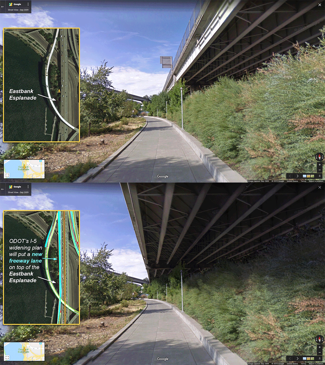
With so many inconvenient truths brought to light recently about the Oregon Department of Transportation’s plans to expand the I-5 freeway, one of the most disturbing is the fact that it would cast an even larger shadow over the Eastbank Esplanade.
The Esplanade, opened in 2001 and named for former Mayor Vera Katz in 2004, is a beloved piece of carfree infrastructure that hugs the western edge of the freeway. It runs between the Steel Bridge in the north and OMSI (SE Caruthers Street) to the south and provides a safe option through the Central Eastside Industrial District. Even though it’s carfree and just yards from the Willamette River, the noise and toxic emissions from drivers using I-5 is ever-present.
That’s why it’s so troubling that ODOT’s I-5 expansion plans would increase the freeway’s negative impacts on the Esplanade.
On page 61 of the Environmental Assessment (whose comment period closes at 4:59 pm this Monday April 1st), ODOT informs us that, “The Build Alternative would also require the acquisition of a 0.11–acre permanent surface easement from the Eastbank Esplanade along the western edge of the SB ramp from I–5 to I–84. The easement would be needed to provide potential intermittent access to the ramp by ODOT maintenance crews. Temporary, periodic closures of the park within the boundaries of the permanent easement may be required to accommodate ODOT maintenance activities.” This permanent easement is in addition to “periodic temporary occupation of segments of the Vera Katz Eastbank Esplanade” during project construction that is likely to lead to several closures of unknown duration.
Advertisement
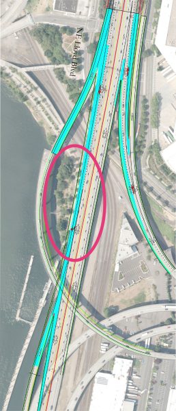
Portlander Iain MacKenzie (with an assist from lawyer Alan Kessler) added considerable flesh to this information by asking ODOT for detailed engineering drawings of the project. MacKenzie made the request on February 15th, the first day of the EA comment period. After a public records request, ODOT finally released a trove of project files on March 26th, just a few days before the end of the comment period. MacKenzie has made the files available to the public via Twitter.
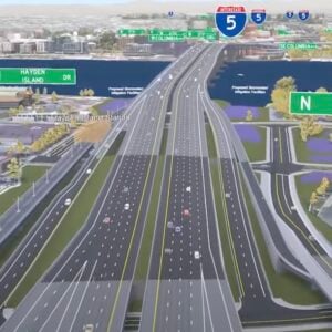
Using those drawings, MacKenzie and Aaron Brown with No More Freeways PDX hired local video simulation firm Cupola Media to create a graphic that shows how the new lanes on I-5 will impact the Esplanade (see lead GIF image).
And this was just one detail of the project that was broadly exposed this week. Both City Observatory and Oregon Public Broadcasting dug deeper into a very interesting project nugget: That all the project’s key projections about traffic and emissions were based on an assumption that a mega-project to expand I-5 between Oregon and Vancouver (like the Columbia River Crossing) would be built. Not only is a new CRC not even on the table, but the fact that ODOT used it to cook their books to make the I-5 Rose Quarter project look better is sneaky at best, and bureaucratic malfeasance at worst.
The longer this project is exposed to an informed public, the more reasons we have to distrust ODOT.
Please consider sharing your thoughts by commenting on the EA (you can submit as many as you’d like). I no longer trust ODOT enough to send you to their website, so if you want to comment please visit https://nomorefreewayspdx.com/publiccomment/.
— Jonathan Maus: (503) 706-8804, @jonathan_maus on Twitter and jonathan@bikeportland.org
Never miss a story. Sign-up for the daily BP Headlines email.
BikePortland needs your support.


Thanks for reading.
BikePortland has served this community with independent community journalism since 2005. We rely on subscriptions from readers like you to survive. Your financial support is vital in keeping this valuable resource alive and well.
Please subscribe today to strengthen and expand our work.
That’s not so bad. Protection from rain. Perhaps less noise.
have you ever ridden under this type of underpass? Like over where the 405 is? This is not a quiet space and adding a lane means more vehicles and louder noises
You might check out the Environmental Assessment’s section on noise – from a cursory look it seemed they didn’t do any analysis of the noise impact on the Eastside Esplanade. That might be worth submitting a comment on.
“Never fear, @OregonDOT isn’t widening the freeway over a popular multi-use path — that’s just an auxiliary roof.”
@press1forjosh https://twitter.com/press1forjosh/status/1111648402289229833
big ups to Alan and Iain for doing the diligence on this! Buy them a beer next time you see them out in public.
That will make the path really attractive for campers.
Hey look at it this way, it will provide good coverage for bike chop-shop operations.
Yes, that “auxiliary” roof will reduce the daylight, rain and solar heat (winter) for this section and thus likely make any green landscaping more sparse…thus easier to camp in.
The issue of closures for maintenance access is an important consideration that all to often is “forgotten” at this point in project scoping/ budget setting. As an example, ODoT/ WADoT frequently use the pedestrian bikeway to “store” equipment and materials whenever they work on the Interstate Bridge (pulley lubrication, discard broken vehicle parts onto, etc.)…thus negatively impacting safety and regional accessibility. SO any such new plan should include mitigation for planned [non-emergency] closures…making upgrades to the planned bikeway detour routes, checking for ADA accessibility, etc. These costs should be tied to this larger project or else they will only even get done in piecemeal and over many decades…
Great work to all involved delivering substantial, detailed information about this project not included in the original EA! We owe you big time for your efforts.
Patrick, I can’t tell if you are being sarcastic, but that extension over the path is gross.
I had the same thought, but then I read the article about temporary and permanent appeasements that would be needed to build this and thought, “What happens when we need to expand the Esplanade because of cycling and pedestrian demand?” I avoid the Esplanade now because it feels full. Some day we will need to widen the Esplanade. This expansion would prevent that or make it significantly more difficult.
I loved that your text editor changed your likely word choice of “easement” and used “appeasement”…that what this process often feels like historically when cyclists have to work with DoTs.
Perhaps. Perhaps less vehicle emissions. Not!
Protection from the rain? Ha. More like funneling of oil and brake dust laden runoff directly below onto the path.
This whole thing is shady
Yes, we need to talk about widening/expanding/improving the EE. Reduce bottlenecks, widen the path, get rid of the hair-pin turn at the bottom of the switchbacks up to Rose Quarter by building a ramp approach to the switchback from the south. Separate biking from walking along here.
So, let’s talk about the improvements made recently during the PPR’s 2-month long closure of this path. One of the improvements was to cut out and completely remove a lot of mature trees along the strip of land between I-5 and the path, near burnside and morrison bridges. This denuded landscape now has no buffer from sight, sound, pollution of the cars and trucks on I-5, where before these trees provided a nice buffer for all these types of auto pollution. It’s hard to understand why PPR removed so many mature trees in one fell swoop. Why did they do this? Seriously reduces the “park-like” aspect of this path.
Smooth out the curve to 84 instead, move I 5 to a buried 405, then remove everything from SW I 5 to I 84 including the Marquam. With this new added Rose Quarter lane, one quarter of our downtown “highway loop” will be modernized and up to seismic standards, making the SE quarter redundant: we do not need two limited access highways through the city center. I don’t mind the cement esplanade cap, it will cool the area in the summer and provide some winter protection. Add a buildable cap around Rosa Parks, dedicated mass transit streetcar lanes to the Broadway, and a Clackamas Overpass protected path to the Broadway Bridge with a bike parking garage connection then this project would be a step forward.
ODOT has been playing dirty and while I was an initial supporter (with major caveats), and still find some of the information being put out by the no more freeways group to be just as biased, we really need a full Environmental Impact Statement. The need for a PBOT easement from the city gives the city a huge amount of leverage. Remember what happened to the half billion natural gas export terminal in North Portland, one needed permit was the lynchpin to killing the whole project and now all future Fossil fuel infrastructure is banned.
Yes! Putting the $500m towards getting rid of I-5 on the East Side would be such a better use of money. ODOT should love that idea, it would be a huge project. How do we get them on board?
And what is the cost after that?
Don’t worry; the plants will still get plenty of light. What I would like to see in that spot is a little boat harbor in the (backwater) cove inside the floating portion. Yes I like to use the Eastbank Esplanade.
Also, let’s not miss this sentence: “Temporary, periodic closures of the park within the boundaries of the permanent easement may be required to accommodate ODOT maintenance activities.”
So more Esplanade closures for freeway maintenance? Thanks, but no thanks.
Between the 10% grade replacement for Flint, the pollution effects on the middle school and this shadow on the esplanade it makes you wonder who really designed this thing, Satan?
That’s my favourite part of riding Vancouver, BC’s paths. They separate wheeled things from walking things. And they gave enough space to have that and even some tree separation in the middle. The westside waterfront park would be wide enough to do that except at least a third of the space is used up by lightposts and those enormous shin-killing ship tie-offs.
As shown, the new lane does not require any new support columns. Is that depiction accurate? I’m highly skeptical that will work structurally, and I assume ODOT is less than forthcoming with that level of detail.
Didn’t an improperly issued permit for a column in the greenway setback ultimately kill the Water Ave on-ramp in pretty much this same location back in the 80s?
Check out the auxiliary lanes out by delta park they put in a few years ago. Definitely added new columns.
http://www.google.com/maps/@45.5876176,-122.6810556,3a,75y,26.01h,88.1t/data=!3m7!1e1!3m5!1szeDt2NGT-_GdMR4ZWx0USw!2e0!6s%2F%2Fgeo3.ggpht.com%2Fcbk%3Fpanoid%3DzeDt2NGT-_GdMR4ZWx0USw%26output%3Dthumbnail%26cb_client%3Dmaps_sv.tactile.gps%26thumb%3D2%26w%3D203%26h%3D100%26yaw%3D356.21167%26pitch%3D0%26thumbfov%3D100!7i13312!8i6656
For anyone who would like to view the drawing themselves, here are a couple links:
A .kmz file that can be opened in Google Earth: https://www.dropbox.com/s/h5j0bkdfti0z4qk/Exhibit_I5_RoseQuarter%20-%20MS3dkmz.kmz
PDF drawings of the project, as submitted to PBOT by ODOT: https://www.dropbox.com/sh/b0v8jnlj3wtpj37/AACIf1NlWgbEm_7f4jCnFTRaa?dl=0
ODOT’s CAD files in DGN format (which can be opened with the free Bentley View application): ftp://ftp.odot.state.or.us/outgoing/Alan_Kessler/
This is Portland right now: The most utilized outdoor public space that showcases the natural beauty of the city and serves as a crucial active transit route is already greatly diminished by noise and air pollution from the horrible idea of running the I-5 through the center of the city. And, city and state officials want to make it worse because “promises” and “you just wouldn’t understand.”
Good observation Sigma, and while doing the image I had had the same thought. All there was to go on was the top-down images – actually the .KMZ I see maccoinnich just posted – that showed the freeway extending to cover the esplanade in this section, so I simply extended the current underside of the freeway to that distance. And once I got it there I had the same thought you had: It didn’t quite look like it should be able to hold itself up without more support. The natural place to put a new pillar would be smack dab in the middle of the path, but I would assume a better solution would be something that extends beyond the edge of the path:
https://www.screencast.com/t/FQ3kyovOGyP
In the absence of information as to the real solution I decided the fair thing would be to leave it at the freeway widening overhead and let people imagine what supports might be required to hold it up.
Possibly, it could end up with a big round column on the sloping river bank. And then a large beam over to the other highway columns. IMO, not a big deal, even if it has to be done more than once.
Thank you TerryD_M, that was exactly what I was going to say: we should be removing I-5 from its current interchange with I-84 all the way down to (and including) the Marquam bridge.
I wasn’t aware of this impact to the Esplanade until now, and what strikes me is that the section of freeway they’re talking about expanding to cover more of the Esplanade is one that would not even exist if we were doing the right thing with I.5
The visualization was create only to show the visual impact of I-5 sticking out further over the Esplanade. I don’t think it was intended to show where any new support columns would go, but I suspect you’re right that they will be needed.
Whether ODOT’s engineers have figured out exactly where they will go, and whether they will impact the Esplanade, is another question. And if they have, whether or not they’re telling us the truth is yet another question, based on how things have gone so far.
Please recall that long ago I identified ODOT’s $200 million fraud at Sellwood.
Nice to know that JM is now on board.
Our greatest asset is that everyone at ODOT is really stupid.
“everyone in ODOT is stupid”. ODOT employs tens of thousands of people. I doubt that BikePortland (BP) would permit the statement “everyone in Nike is stupid” or “everyone who is poor is stupid”. Those blanket generalizations are lies, insulting and wrong. Everyone in ODOT includes the plow drivers in the Blue Mts., fishery biologists protecting endangered salmon as well as the engineers and planners whose projects you protest. In its enthusiasm to kill the Rose Quarter project Bike Portland is deviating from its long held policy of courtesy and prohibiting defamatory language. When BP moves from protesting projects to being a platform for mischaracterizing and vilifying whole groups of people your integrity diminishes.
From the drawings I’ve seen the location and number of support columns required has not yet been determined, other than where they occur in the river itself.
PPR have really turned into enthusiastic tree canopy eradicators lately. Removal of mature trees on Esplanade is quite like what they did on the Sellwood Gap last week for extra-wide path pavement: https://twitter.com/EdithMirante/status/1108477261433303040
What she said. Time to find out what in heck is going on with Parks. Seems like they should work a little harder to preserve existing trees. Anybody know what species the trees were?
Replying to X, I’m not sure what species of trees were cut down on the Esplanade but when originally planted, native Oregon species were emphasized; Google street view shows a mixture of conifers incl. pine + deciduous. Portland Parks appears to have labeled them all “dead” in its press materials about their recent Esplanade work.
In their Sellwood Gap “Red Wedding” March 20-22 Portland Parks cut down walnut, native hemlock, cherry, apple, plum, maple, native doug fir among others, and tore out every other plant along the south side of the tracks fromSE 9th to 11th, incl. lilac, juniper and hawthorn. They considered it all a worthless nuisance to be removed for their 16 ft. extra-wide pavement with various excuses including “bike safety.” They’re refusing to replant any trees in the same site.
Sure hope no feral trees colonize the open space.
Well I don’t read the O (much) but their banner headline said Kate Brown was now supporting the CRC. Did I get that right? Idaho stop thing.
Comment nesting seems off somehow.
Is the Vera Katz Esplanade beloved? I think we’re about to find out. This amounts to a “taking”, as in depreciating a thing to the degree that it’s more or less dead. ODOT misrule of our surface streets isn’t enough, now they get to close a valuable and nearly unique Portland asset at will??? It’s a good place to visit and also one of the best North-South human power thoroughfares existing in Portland. With all of its faults the Esplanade is a Portland icon. ODOT, is this where you want to throw shade?
“The Esplanade, opened in 2001 and named for former Mayor Vera Katz in 2004, is a beloved piece of carfree infrastructure”
I don’t know if I would call the Eastside Esplande “beloved”. It’s better than nothing but it’s not exactly a joy with all the noise, pollution, and limited access.
And those much beloved big bumps on the ramps to the floating sections of the trail.
This doesn’t look so bad. I-5 is a real bottle neck through the rose quarter and really does need improvement.
The mock up picture, as bad as it is, still paints a far-rosier picture than what the reality will be. Other folks have already mentioned that the highway will need supports that extend into or across the path, but you can also say goodbye to all those beautiful plants that the highway will cover.
Heh — Nice Gore call-out!
Nice work as usual, Cupola Media.
That said, I just showed this to an urban ecologist and they pointed out that the after-build scene would be different in another important way: the shadow and overhanging highway could very well end up killing the plants on the right, literally creating a dead space.
Is this all we should expect from ODOT? Zombie Freeways?
It seems every year a new freeway expansion proposal is made. Every year we are told this project will solve traffic problems. Every year the data is massaged to accommodate incredulous projections.
The monstrous Columbia River Crossing proposed a similarly unnecessary freeway expansion under similarly faulty projections of increased demand. I saw those well-paid consultants laughed out of meeting rooms. At public meetings they were brutally mocked for wasting our public funds on a boondoggle that would have tied up all our state’s transportation money for a decade. This project uses data that presumes a massive new I-5 bridge across the Columbia River will be built. Once again, Zombie Freeway rises from the dead to prey upon the living.
It doesn’t have to be this way. We could work together to examine and address traffic concerns. We could build infrastructure that doesn’t contribute to childhood asthma. We could repair our existing bridges that are rated by the Army Corps of Engineers as “Poor” or worse. We could make a plan that takes into account the greatest threat to human life on this planet; call it climate change, call it global warming, but rest assured we won’t be calling it business as usual. We could do all this and more if ODOT wasn’t solely focused on trying to build its way out of congestion, which, due to induced demand, has never worked. 1000s of cities across the planet have shown this to be true: if you build it they will come. Cars are already the number one cause of death for those under 37. Wider freeways means more cars, which means more death.
Please stop throttling the future by burning the past.*
*modified from Fossilosopher Lee Henderson
“Not only is a new CRC not even on the table, but the fact that ODOT used it to cook their books to make the I-5 Rose Quarter project look better is sneaky at best, and bureaucratic malfeasance at worst.”
It’s not called exactly that, but SW Washington Dems have requested $450 million to begin an “I-5 Bridge Replacement” plan. I guess this would be the lead up to an eventual $20 billion “Portland I-5 Replacement” plan. Or something like that.
My thinking is that ODOT wants to do this project first to help build the case for a big CRC. Last time, there were complaints that the CRC would dump huge volumes of traffic into the Rose Quarter with nowhere for it to go. With this project, it will have someplace to go.
Possibly. But right now it is the SW Washington Dems, led by Sen. Annette Cleveland, who are asking for $450 million towards an “I-5 bridge replacement.”
More Space and shelter for the homeless chopping up all the stolen bikes!