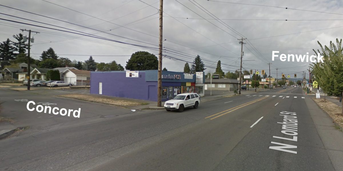
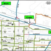
The Concord Avenue neighborhood greenway has only one gap in its 2.4 mile route between Overlook Park and North Argyle Street in the Kenton neighborhood: the offset crossing of Lombard Street (a.k.a. Highway 30). But with a new agreement between the Oregon Department of Transportation (they own and manage Lombard) and the Portland Bureau of Transportation, that gap will soon be filled.
The two agencies recently hashed out an intergovernmental agreement (IGA) so that PBOT could do the work to build a new crossing that will link Concord on the south side of Lombard with Fenwick to the north. It’s a much-needed upgrade to an intersection isn’t as safe as it should be. Not only is this a designated neighborhood greenway route, but it’s a popular connector between two neighborhoods (Arbor Lodge and Kenton) and there’s a high school directly adjacent to it.
Advertisement
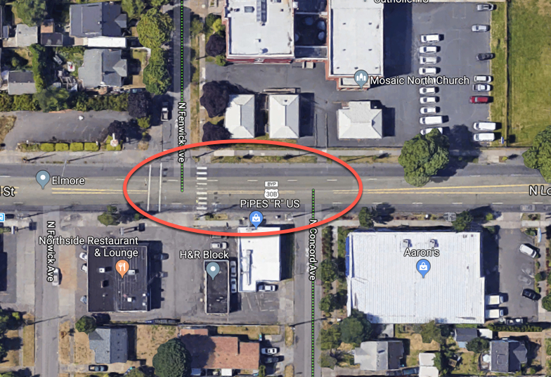
The existing crossing infrastructure — known as a pedestrian half-signal — is also not compliant with federal guidelines. A half-signal exists when there’s a standard traffic signal for the major road, but only stop signs for the minor roads. The Manual on Uniform Traffic Control Devices (MUTCD) explicitly prohibits the use of half-signals due to safety concerns. Studies have shown that when someone actuates the traffic signal on the main road, drivers from the side-street think it’s an opportunity to turn and they don’t realize (or they don’t see) the people in the crosswalk. As of 2015, Portland had 47 such signals and because they’re not recommended by the MUTCD, we haven’t installed one since 1986.
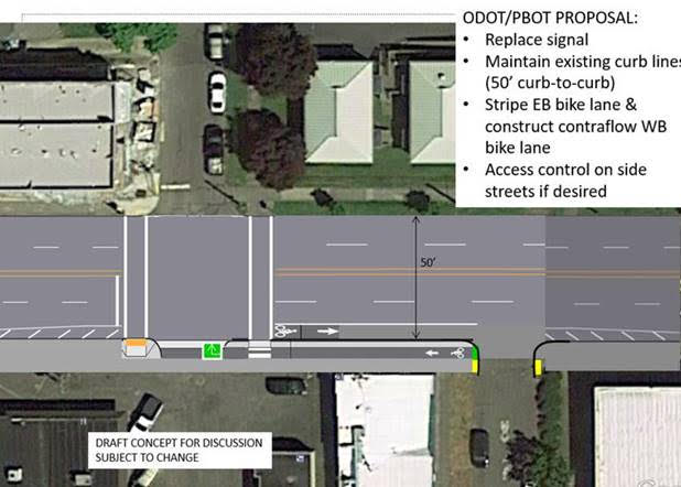
PBOT plans to spend $2 million in Transportation System Development Charges to improve this crossing. In addition to the full signal upgrade they plan to add ADA improvements to the curbs and sidewalk, and create a new bike lane on Lombard. As you can see in the latest concept drawing, the plan is to stripe an unprotected, five-feet wide eastbound bike lane and create a westbound bike lane on the sidewalk for the short distance between Concord and the crossing at Fenwick.
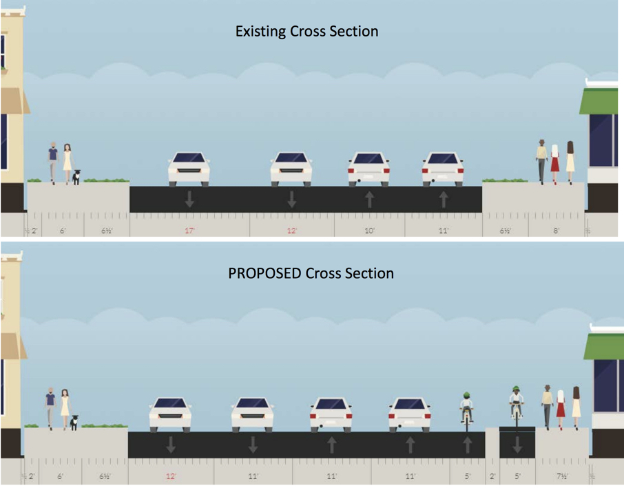
As you can see in the cross-sections below, the bike lanes would be separated by a two-foot buffer. The space to add them would come from an existing planted median on the sidewalk and from narrowing one of the existing lanes:
Longtime readers will recall that we first mentioned an improvement at this crossing in 2010.
PBOT Communications Director John Brady said today that with the IGA with ODOT now signed, they can move onto final design work. It will be a few months yet until we get an estimated date of completion. Stay tuned.
— Jonathan Maus: (503) 706-8804, @jonathan_maus on Twitter and jonathan@bikeportland.org
Never miss a story. Sign-up for the daily BP Headlines email.
BikePortland needs your support.


Thanks for reading.
BikePortland has served this community with independent community journalism since 2005. We rely on subscriptions from readers like you to survive. Your financial support is vital in keeping this valuable resource alive and well.
Please subscribe today to strengthen and expand our work.
I lived in Vacouver BC for 4 years (2002-08) and used a bike as my primary transportation and the half-signals were very common on the bike routes. I really loved them. In my experience, they have much better compliance for stopping cross traffic than the Rapid Flashing Beacon or the HAWK signals. They also seem to do a better job at discouraging driving on the bike routes since drivers would not trigger them (they were button-activated which I did not love) and drivers would be forced to wait for bikes and pedestrians and would often not make it through a signal cycle and get stuck awaiting for a long time. I can see how they could appear dangerous, but that was never my personal experience. For this intersection, a full signal seems like overkill, and I am concerned that it would incentivize people driving on Concord; however, I greatly prefer the full signal over the RRFB or HAWK.
They may not be the ideal design but I use the one on SE Taylor at Chavez (by the library) and at 41st and Hawthorne a lot, and I like them just fine. I also don’t think there’s any significant crash history for the one on Taylor/Chavez..?
This is incorrect. The MUTCD is not a law, it is a policy manual. Portland has repeatedly chosen to use non-MUTCD compliant traffic control devices. Moreover, the city of Seattle has over 100 half signals and still prefers them over similarly-priced HAWK signal at many locations.
Can you please post citations. Moreover, I would argue that the appropriate comparison is between a HAWK signal and a half signal, not with a full signal.
I should also note that a study of Portland’s half signals found that they did not significantly differ from full signals when it came to crosswalk crash rates involving pedestrians:
“Crash rates were 0.158 and 0.178 crashes per million entering vehicles for
3-leg and 4-leg half-signals and these rates did not differ significantly from the minor
street stop controlled and signalized comparison groups.”
https://pdxscholar.library.pdx.edu/cgi/viewcontent.cgi?article=3201&context=open_access_etds
Yeah…instead we installed many HAWK signals which match the same “risk” with even more risk of non-compliant light running.
PBOT’s history with non-MUTCD compliant designs is not relevant for this project. It’s an ODOT facility, not PBOT. ODOT is unlikely to design something that doesn’t comply with MUTCD.
This design violates our most foundational traffic law: drive/ride on the right. Guaranteed people will be riding the wrong way (as intended) down the bike lane because it’s technically the correct side of the cycle path to ride on.
My question is who approves these literally backwards designs?
States typically adopt the MUTCD with amendments relative to that state. California permits half signals.
I’m not following the argument behind your comment. Are you saying that PBOT shouldn’t do anything at this intersection?
My comment was pro-half-signal and did not address the project.
FWIW, I think the proposal is a definite improvement but I’d prefer that the curb be placed in front of the bidirectional bike facility.
The signal would stop traffic though, so I don’t think cars would be next to people biking unless they blew the red light right?
It takes a while to cross, turn left, and negotiate the half block so there would be cars next to the people occasionally. I don’t understand why putting the curb on the outside was not the automatic choice.
I think because then the 2 way cycle track would have westbound bicyclists next to the curb, without a bike lane buffer, facing and adjacent to oncoming traffic. I would find that very uncomfortable.
People on bikes aren’t going to be going fast. There are not a lot of people walking at this intersection. Why not extend the sidewalk another 5′ and make it a MUP? Separation between people on bikes and people walking is necessary only when there is a large speed discrepancy.
You are probably correct. ODOT likes to maintain a consistent curb-to-curb width on state highways, especially roads like Lombard that are overdimensional freight routes. There shouldn’t be any conflict because of the signal phasing, so it’s not a big deal in my opinion.
I think the width has something to do with turning movements of big-rig semis and the radius they need, such as moving trucks going to neighborhoods or grocery semis turning into Safeway.
Like every state in the USA, ODOT maintains its own online GIS system, though it’s a bit clunky compared to PBOT’s. https://gis.odot.state.or.us/transgis/
According to ODOT, in 2017 this stretch of roadway had 19,900 vehicles per day on average (AADT). Kinda useful if anyone is thinking that Lombard could use a road diet.
Lombard is US Highway 30, but is also State Highway 123.
This is helpful. Thank you!
Brentwood-Darlington’s name isn’t even on ODOT’s map. “Say my name, ODOT!”
It’s not daily traffic that indicates a road diet is possible, its peak hour.
Could you elaborate? What are the thresholds for allowing a road diet? What kind of peak AM or PM volume prohibits or inhibits a road diet?
The rule of thumb is 1,000 vph, though I have seen 1,300 vehicles per hour on Division east of 52nd.
This is the threshold for one lane of traffic. If you have less than this in one direction, that direction does not need more than one lane.
Help me to understand this so I don’t completely screw up on it later. Can I assume that it’s 1,000 vph on both lanes combined, in one direction? That for any street that has over 1,000 vph during any one-hour period, for all days averaged over the year, that a road diet is not a good idea, even if the other 23 hours traffic is considerably less than 1,000 vph? Should special events be considered or ignored in this calculation? (i.e., congestion on I-5 or a nearby event creates an increase in local traffic.) Is there any special consideration for truck/freight traffic (vph)?
The 4 lane design is inherently dangerous. ODOT knows this. The more important question is not whether there is enough wiggle room in the VPM calculus. It is rather how many people we think should die or be injured by an intrinsically flawed design.
https://streets.mn/2014/10/28/four-lane-death-roads-should-be-illegal/
1,000-1,300 vehicles per lane per hour is the rule of thumb. It is a first look, as are most rules of thumb, not the end of analysis. So if both lanes going one direction total to 800 vph, then that direction is way over capacity (more space supplied than demand).
Short duration congestion is acceptable most everywhere, LOS D or E for short periods. I suspect that 1,500-1,800 vplph might be the tipping point, but again, modeling can assist with relief strategies, like dedicated turn lanes at the bottlenecks (major intersections).
Trucks, buses, etc., and their effects on the flow can also be modeled.
Few roads are designed for event traffic, hence congestion when events end, and things like reversible lanes, both sides of the centerline going one direction for a limited distance, etc.
On the pedestrian half-signal: isn’t the new crossing at NE 26th and NE Broadway exactly this type of signal design where the main road gets a red light but the side streets have only a stop sign? So why is considered ok/safe to install in one place and must be removed somewhere else because it is not compliant?
That’s a HAWK signal which has a “triangle” of three lights that change from flashing yellow, to solid red, and flashing red.
Pedestrian Hybrid Beacons are permitted in the MUTCD. It says they should not be placed at intersections, not ‘shall not’.
lol cyclists getting a left-hand lane like it’s England or something
Just greet opposing cyclists with a friendly “Cheerio” and be on your way.
This really just formalizes what people have been doing at this intersection for years.
The 2-foot buffer was between the westbound bikes and car lane in the original proposal.
Seems like a reasonable way to deal with this spot. I’m glad to see they are actually crushing concrete (and not just splashing paint) in this project – it shows commitment, although I suspect that might all be for the ADA portion of this project.
I wonder if there were any significant street trees currently in the planting section they plan to pave over if they would use this design or scuttle the whole westbound raised-bike lane part of this project and just mix the two bike lane directions together on the street.
Issue with bike lanes on Lombard is that people tend to park their cars in them.
Isn’t there another (highly valuable) three to five feet available to work with here?
“Lane widths of 10 feet are appropriate in urban areas and have a positive impact on a street’s safety without impacting traffic operations. For designated truck or transit routes, one travel lane of 11 feet may be used in each direction.” – NACTO
https://nacto.org/publication/urban-street-design-guide/street-design-elements/lane-width/
tell that to ODOT.
The original proposal shifted the car lanes and used an 11/10/10/11 auto lane cross section to maximize south side space for the jog.
Side street access management means something similar to 33rd and Going, with car entry prohibition except for bikes. Not that feasible on the north side with the school.
Do you mean that east-bound school buses need to be able to turn north onto Fenwick? And west-bound school buses need to turn left from Fenwick onto Lombard?
Its a private school renting PPS facility (Seton?). It’s a traffic issue, no school busses. The two streets that back the school are residential streets, so blocking the one next to the school only pushes that traffic to another residential street. The Russet Street on the north side is blocked at Interstate by the light rail lines. The first E-W street north of the school with a signal on Interstate is the Terry greenway.
A 5 foot bike striped lane next to to two 11 Foot lanes is quite nuts. The next gem in this sea of excitement is the 12 foot lane on the opposite side. Vehicles by law are a max of of 8.5 feet wide. So, why does it need to be 12? All this will do is encourage CMV’s to race eachother in that right lane. Lombard should be a max of 10 feet from I-5 to the bridge. But…that would just be good for people right?
this put’s CMV’s right next to bikes, at high speeds. Who will die first?
AFAIK, half signals are “discouraged” which is very different from “prohibited”
Thanks. I will take a closer look at that.
Please, no bikeways that make it appear that you are riding against traffic on the sidewalk.