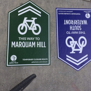
(Photo: @madeyerish on Twitter)
If you are one of the 2,500 or so OHSU employees who bike to campus and use the Portland Aerial Tram to get that free lift up to Marquam Hill, remember that you’ll have to change your plans for the next five weeks.
As we shared last fall, a routine maintenance project will close the tram tomorrow through the end of next month (July 30th). The bad news is that people will have to figure out other ways to get up the hill — none of which will be as easy or convenient. But the good news is that the Portland Aerial Tram, OHSU and other agencies are pulling out all the stops to make sure things go as smoothly as possible during the closure.
The GoByTram.com website has all the information you need to plan your trip by transit, biking, or walking. There’s even a frequent daily shuttle service they’ve set up just for the closure.
When it comes to biking, here’s what you need to know:
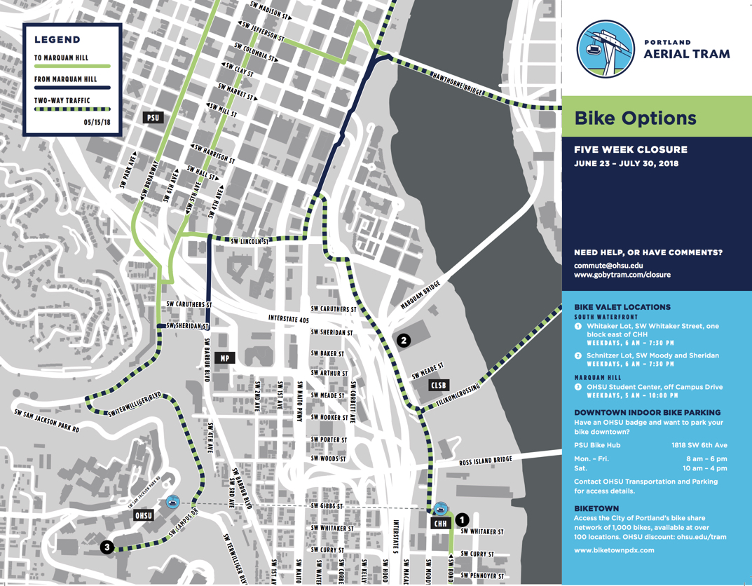
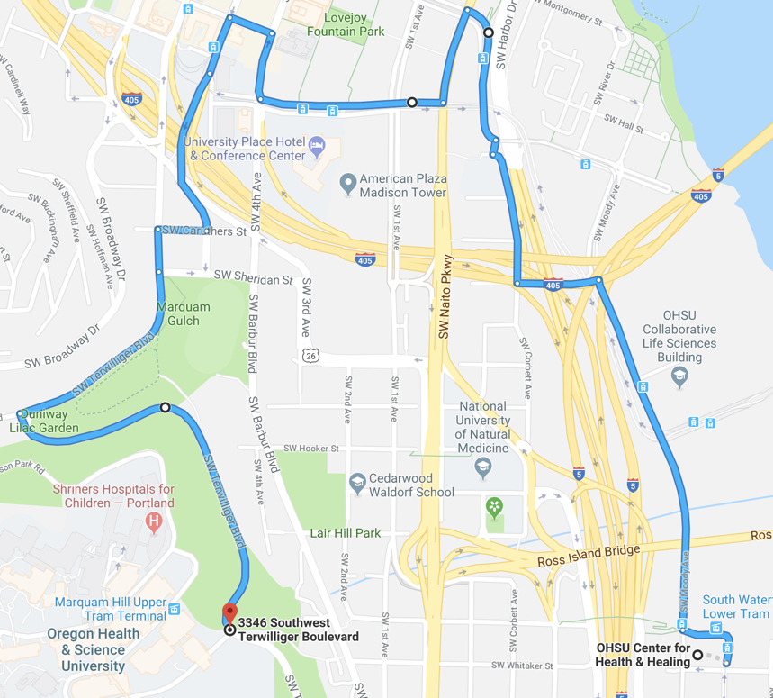
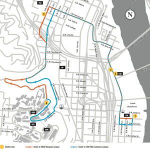
➤ The recommended bike route from the Waterfront to the hill is about 2.5 miles and requires about 300-feet of climbing. Google says it’ll only take you 20 minutes but your timing may vary of course.
Advertisement

(Photo: @ckocur on Twitter)
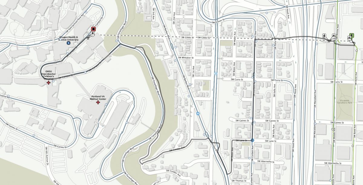
➤ TriMet’s multimodal trip planner offers a different route than Google and takes you over the Gibbs Street Bridge and up to Terwilliger via Condor.
➤ To help you find your way, OHSU has installed special pavement markings with arrows pointing toward either the hill or the South Waterfront.
➤ Look for cycling guides wearing special yellow and green Portland Aerial Tram jerseys. They’ll be able to answer your questions and help you find your way if you get lost.
➤ If you’d rather not ride all the way up, grab a Biketown in South Waterfront and ride to transit stops downtown where you can catch buses or the shuttle up the hill (the top of the hill is out of the service area). You can get a $20 Biketown credit with promo code “TRAM18”.
➤ You can also ride your own bike downtown and take advantage of free, secure bike parking at the PSU Bike Hub (1818 SW 6th Ave), then hop on transit to get up the hill.
➤ If you want a boost of power for the climb, a special electric bike share program will be available to OHSU students and staff to travel between the waterfront and the hill. (We’ve heard the bikes will come from Jump and Lime but couldn’t confirm any other details by press time.)
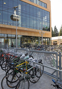
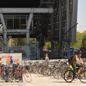
➤ Use one of three Go By Bike valet locations. They’ll be set up in the Waterfront area in the Whitaker and Schnitzer parking lots. Up on the hill, they’ll be at the OHSU Student Center. According to a video released by OHSU, Go By Bike will transport bikes from the Whitaker Lot to the Student Center so you can ride downhill after work. For more on the valet locations and other biking amenities that will be provided during the closure, I’ve made a shortened clip of that video that highlights only the bike-specific information:
For updates, advice and more information follow @PortlandTram on Twitter and check the official closure website.
— Jonathan Maus: (503) 706-8804, @jonathan_maus on Twitter and jonathan@bikeportland.org
Never miss a story. Sign-up for the daily BP Headlines email.
BikePortland needs your support.



Thanks for reading.
BikePortland has served this community with independent community journalism since 2005. We rely on subscriptions from readers like you to survive. Your financial support is vital in keeping this valuable resource alive and well.
Please subscribe today to strengthen and expand our work.
The SW Broadway route to Marquam hill partially blocked in a very confusing manner by a construction zone. People biking are now allowed to use the narrow pedestrian detour but this is not clearly communicated by a tiny sign.
Given that many people who use the tram cross the river via the Hawthorne bridge this could be a problem. IMO, well-indicated detour routes from the Hawthorne bridge are also important.
Agreed that a route from Hawthorne should be posted.
It will be interesting to see what happens since I suspect that most people who use the bike valet and take the tram up wouldn’t normally go to the base of it in first place so a totally different route would be better.
There are multiple ways up and down. The trimet recommended one is good but steep. People who like hills will love it, others will hate it. An alternative is to drop on Hamilton rather than Condor and doubling back on Corbett. Also very steep and makes the ride longer, but it also makes for a better Barbur crossing.
I don’t think much of the google one as it is both needlessly long and requires significant comfort with traffic. Anyone who finds Portland traffic challenging should probably avoid it. BTW, the google map ends below anything useful — just about anywhere people might actually go requires another 200 feet or so of climbing.
For people coming up Terwilleger wh don’t like traffic, just take the very wide sidewalk from Sheridan. Going uphill, you’ll have total separation from the traffic and the few peds that are there won’t care because you’ll be going slowly.
It only takes about 25 minutes to walk from the bottom, so people who don’t like climbing hills can probably walk it just about as fast as they ride. Anyone who works up enough of a sweat climbing to need a shower will find it takes more time to ride and shower than just walk.
If cycling up the hill doesn’t sound fun, I’d recommend walking. It’s a nice walk.
I like the cyclecross-style carrying my bike up the rebuilt trail on SW Woods Street from the traffic light at SW Hooker Street. The trail at 4th street at Woods goes to SW Terwilliger.
Most people aren’t going to want to ride down Corbett with the i5 offramp and no bike lane. Crossing Barbur at Hamilton might not get you right-hooked at Hamilton since you’re turning right, but most people will probably still get squeezed to the curb by turning cars.
The bottom of Condor has a signed crosswalk which works okay if you’re firm but patient, though you have to watch out for double jeopardy.
Soren,
That’s been a thorn in our sides since the construction began. We have been working with the city to allow us to use better signage and include ground markings similar to the sidewalks on the Burnside Bridge to delineate the space and to route riders correctly. Hopefully that will be corrected very soon.
SW Trails has asked PBOT for years for a legit crosswalk of Naito to the south of the Ross Island Bridge interchange.
Yeah, what happened with that? I was on an official PBOT ride a few years ago and we paused where Whitaker ends with some steps leading up to Pacific Hwy. The PBOT ride leader indicated there would soon be a flashing beacon crossing there to continue up Whitaker on the West side of Pacific Hwy.
Btw, your image of the Google version of the uphill route is wrong. It should look more like this:
https://www.google.com/maps/dir/45.4991574,-122.6709975/45.4991799,-122.6825954/@45.5039505,-122.6801578,16z/data=!4m24!4m23!1m20!3m4!1m2!1d-122.6752326!2d45.5063675!3s0x54950a6ca1485261:0xe1fac274f4781d40!3m4!1m2!1d-122.6766189!2d45.5090713!3s0x54950a1373680e81:0xd6eb7bc2a8fed598!3m4!1m2!1d-122.6825854!2d45.5081703!3s0x54950a1452a23c0f:0x4ebf505154751aeb!3m4!1m2!1d-122.6842156!2d45.507124!3s0x54950a159c59bbb5:0xf3122117b57fb777!1m0!3e1
The route between Lincoln and Terwilliger / the turn at Sam Jackson is sketchy in both directions. Note the differences from google’s directions at Harbor Dr. + Water Ave vs the viaduct — worth exploring if you want to ride left-side sidewalk up Harrison rather than use the crosswalk at the top (Naito bikeway is also left-side there.) Also, via the sidewalk bikeway to the bike signal crossing at 5th off the end of Lincoln. If you’re going to pull off to the left of 5th and not ride in the bus lane through that signal, don’t go around the block at 4th and Lincoln.
In any case, how many people want to merge across Sam Jackson traffic into a left-turn pocket to wait for a green arrow and then suck on car exhaust while climbing the steepest part of the hill on the right-hand bike lane overgrown with thorny blackberry canes? There is a curb-cut on 5th that will take you across Broadway to the sidewalk on the left side of 6th/Terwilliger. One could also ride out Broadway/6th/Terwilliger bike lane and cross left to the park sidepath. You need to be super careful at intersections when riding on the left-side sidewalk, but the most dangerous thing riding slowly up the hill on the left are the dirty looks from people walking their dogs (don’t be a jerk.)
PBOT + Portland Parks could do everyone a favor and make a car-free Condor for a month.
Coming down Terwilliger, you should ride in the bike lane if you’re going fast but beware the lost bike lane at the bottom as it meets Sam Jackson and tight spots where it curves around to become 6th. I can’t imagine trying to thread through the left from Sheridan to 4th across two lanes at a standstill headed for Ross Island bridge and one speeding through to Barbur. It might be nicer to peel off into the crosswalk to Lincoln where the bike lane peters-out on 6th. If you’re in a hurry and feeling vehicular, maybe follow 26 to Hood Ave, Kelly and the Gibbs bridge.
Seriously, don’t be a jerk if you use the sidepath! Back when I lived over there and walked my dog, most cyclists were fine, but I dealt with close calls a few times per month. If you’re going uphill, gravity will usually keep you in check. Just be aware that there are a ton of elderly residents from Terwilliger Plaza who are out and about on the sidepath, particularly between OHSU and Duniway Park. I watched a cyclist take out an old lady back in November and it was upsetting to say the least.
As someone who’s been riding this section every workday for years, I’d say most of the things people seem worried about are not the real problems. Compared to other stuff you have to deal with, the bike lane on Terwilleger is the easy part even with blackberries and a few rocks scattered in the lane.
Of the concerns brought up, the thing I’d expect people would like the least is that when traffic is heavy but still moving along Sam Jackson, less confident riders might find difficulty pushing their way across the lane in much faster but tightly spaced traffic so they can transition from Sam Jackson to Terwilleger.
People keep saying Terwilleger is steep but it’s not even close to the steepest thing you’ll hit. Campus Drive over Terwilleger is much steeper as are Condor and Hamilton. Going down, there is no bike lane whatsoever on Campus Drive and the traffic really gets backed up. Going down Sam Jackson, there is also no bike lane and traffic gets backed up there too. There is no route going down where you won’t have to get close to traffic.
When you get to the top, OHSU bike facilities suck despite the fact they want them to be good. There are very few places to lock up and the bike room I’m allowed to use is pretty hopeless. The only reason things work as well as they do is that few people take their bikes up, and hardly any of them actually pedal up.
Most people who can pedal up without being a mess is going to be fine with the traffic. Most people who’d have difficulty with the traffic would also have trouble with the hill. I have never had a negative interaction with any kind of vehicle on the hill — the traffic here is easier than what you’ll have to deal with once you get to Barbur or Sheridan.
Walking is an underrated way to get around. Relatively efficient, scenic, and low stress. I would recommend anyone with concerns to give that a shot.
Bravo to OHSU for installing special pavement markings with arrows [aka way finding for bicyclists). But has PBoT done any emergency climbing bike lanes or downhill [orange] sharrows?
i tried to follow the detour signs this Sun but once i got to naito there were no more visible signs. i suspect people are meant to take the mup to lincoln but this is completely non-intuitive. i simply took the sharrowed route up harrison but this requires an angled jog across street-car tracks to continue to 5th or broadway.
The Biketown $20 credit works! Thanks TRAM!!
An email sent to staff on Sunday that I just got around to reading contained some information I wasn’t previously aware of:
“We will also be shuttling bikes up from the Schnitzer lot to the Student Center during the day so you can ride your bike downhill home instead of getting on another shuttle. When you leave your bike at the Schnitzer and ask for a bike shuttle tag. You will get a text notification when your bike has arrived on the hill. ”
In other words, if you previously took your bike on the tram and don’t want to ride up the hill, you’re covered. If you haven’t taken your bike on the hill, you have another option.
Having said that, there’s more to safely descending than meets the eye and it’s a good idea to avoid riding down hills you can’t ride up for a variety of reasons. There are no routes on Marquam with bike lane all the way down, and those who are uncomfortable with traffic will probably feel crowded even where there are lanes.