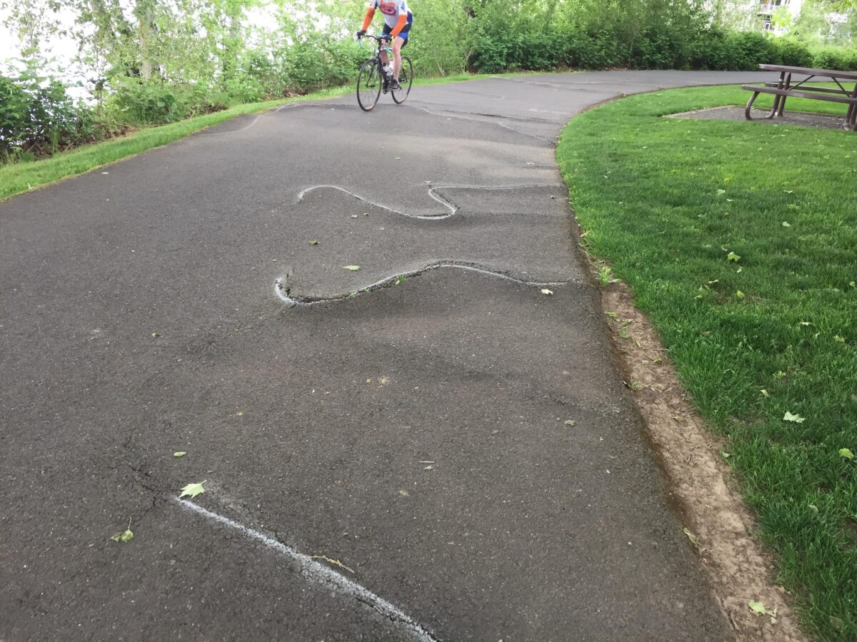
(Photo: David Stabler)

Portland Parks & Recreation plans to close a portion of the Willamette Greenway Trail starting tomorrow (June 5th). The closure will allow work crews to flatten out several sections where tree roots have caused bumps and cracks in the pavement across the path.
Parks says they’ve known about this uneven pavement for a while now, but they bumped up the timeline due to the upcoming four-month closure of the Springwater Corridor on the other side of the river. That closure begins July 1 is expected to route many people to the Willamette Greenway Trail as an alternate. In addition to the Springwater project, Parks also heard from concerned bicycle users who reported the bumps.
Advertisement
BikePortland subscriber David Stabler reported the problem and requested the repairs in a post on April 11th.
Parks said the 3-4 day closure will start at 8:00 am and last no later than 7:00 pm daily. Please note that you will not be allowed to pass through the work zone during that time. Parks suggests using the Sellwood, Tilikum or Hawthorne Bridges to get to the west side of the river. They should have signs up warning about the closure as of today (if they don’t, let me know and we’ll remind them).
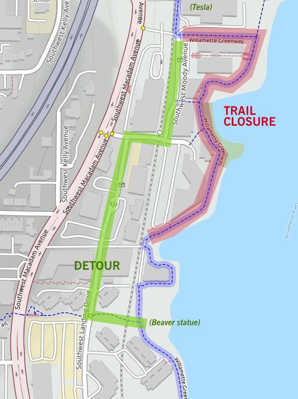
UPDATE, 6/6: The map below was created by reader Paul Souders. It shows how to easily navigate around the closure:
— Jonathan Maus: (503) 706-8804, @jonathan_maus on Twitter and jonathan@bikeportland.org
Never miss a story. Sign-up for the daily BP Headlines email.
BikePortland needs your support.


Thanks for reading.
BikePortland has served this community with independent community journalism since 2005. We rely on subscriptions from readers like you to survive. Your financial support is vital in keeping this valuable resource alive and well.
Please subscribe today to strengthen and expand our work.
Glad to hear PPR is doing what it can to make this route better during the Springwater Closure. Hopefully the 19th ave Greenway (the alternate route on the east side) will also be ready. I just emailed the PM at PBOT – they are racing to get it done but there’s a chance it won’t be striped in time (meaning the beacons for difficult crossing will be off as well).
I doubt we’ll need to reroute to the east side to avoid this. You can probably bypass the work area (from North to South) by taking Landing Drive from Hamilton to the unnamed path just past the Oxbow 49 building. (It connects to the Greenway trail by the beaver statue.)
When critical roadways (highways, freeways) need to be closed for work, the work is done at night so that the closure impacts as few people as possible. Why is this not the norm for bike paths? Oh yeah, bikes are at the bottom of the priority pyramid.
Good point…though there may be environmental restrictions along this section depending on the season and such…
I wonder if the proximity to residences has anything to do with that.
Roadway, highways and freeways have room to park trucks and allow very, very wide motor vehicles to pass. Pathways in Portland are about 80% of the width of the average work truck. I’ll leave the rest of the math to you.
I woke up being loaded into an ambulance Friday afternoon after hitting some similar features on the Fanno Creek trail so this is good to see. Hopefully it didn’t take someone breaking bones in their face and hand to finally bring it about… still waiting to hear back if Tigard and THPRD will do something about Fanno Creek out here on westside.
Update:
THPRD ground some of their trail flat over the past few months however the worst of it is on Tigards end of the path. City got back to me saying after looking at trail they are going to begin grinding this week and potential repaving this summer. Which… is good, however strikes me like they were unaware of the issue and the urgency they seem to now have after I injured myself seems to show a lack a priority seeing that these risks have existed for years and it’s apparently something they can go start work on within just a weeks notice…?
It could be that it takes a crash/injury to elevate lumpy pavement to high priority.
Or it could be that not enough people report lumpy pavement. I’m reading comments from people who crashed on such pavement and people who avoid such pavement, but I’m not reading that they ever reported those pavement conditions.
great news, I just rode this on Sunday and made a note to self to complain to Parks about how unsafe it is. Thanks to David S. for making the effort to report this. My impression is that agencies like Parks/PBOT/ODOT are often complaint-driven; if you put them on notice of a safety hazard it obviates the legal protection of plausible deniability (“we didn’t know”).
I rode this a couple weeks ago and noticed the path is in pretty bad shape, so glad to hear it’s getting fixed.
Agree with axoplasm that Landing Drive is a suitable, reasonably low-traffic (and potentially more direct) alternate.
Rode through there last night. Looks like they were doing full excavation, not just grinding them down. SB I was able to get past the Tesla service station and the Kelly Services building before finding the closure, You could save a little time from SoWa, by just taking the Moody trail instead of going around Spaghetti Factory and back to Moody. Also heating south be ready to shift into a very low gear. The hill on SW Hamilton while very short is also VERY steep up to SW Landing. From there I was able to take the first reconnect to the greenway on the left after the new Apartment building.
UPDATE, 6/6: The map below was created by reader Paul Souders. It shows how to easily navigate around the closure:

wow. I’ve avoided this trail for about 10 years due to this issue. I’m glad to see it’s finally getting some attention.
I rode through there today and figured out that very detour, thanks to the omniscient Googles.
Rode this trail this morning and it’s all done, fyi…