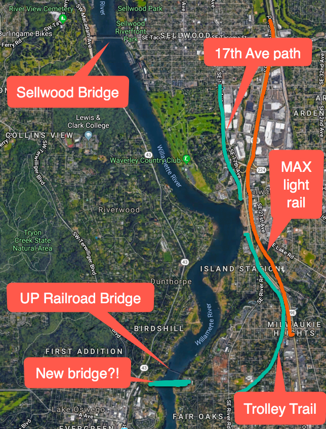
A cycling and walking bridge over the Willamette River between Lake Oswego and the Milwaukie/Oak Grove area has been dreamt about for decades. But now, in part due to completion of the Portland-Milwaukie MAX light rail line and the success of the Trolley Trail, there’s new momentum to actually build it.
“I can’t think of a project that serves more people potentially.”
— Paul Savas, Clackamas County Commissioner
Today at a meeting of the Clackamas County Commission, county planners received approval to apply for a $306,000 Metro grant for the Willamette River Bridge Feasibility Study. The grant is part of a $2 million pot of “regional flexible funds” to be doled be doled out by Metro that aims to get more active transportation projects up to shovel-ready status.
Amazingly, the commissioner who spoke most highly of a new, carfree Willamette River bridge was none other than Paul Savas. This is notable because it was Savas who, during a debate at Metro Council in 2016, tried to pass an amendment that would have wiped out this pot of funding and instead put more money into developing freeway projects. Now his tune has changed. Noting that there are large populations on both sides of the river where this bridge will likely be built, Savas said, “What makes this concept so viable is that… Bar none, I can’t think of a project that serves more people potentially.”
Savas is right. The concept is tantalizing.
The inspiration for the project is the existing Union Pacific Railroad bridge that currently stretches between the beginning of N State Street (near the southern terminus of the path through Tryon Creek Park) and Rivervilla Park in Oak Grove. In 2009 Metro studied the possibility of a cantilevered path on that bridge. When UPRR balked, advocates and planners realized a new bridge was the only alternative.
Advertisement
Since then, Clackamas County has been plotting a low-car transportation system that is shaping up nicely. The six-mile Trolley Trail (which comes within just a half-mile of a potential future bridge alignment) opened in 2012, the Orange MAX line connected Milwaukie to Portland in 2015, and a separated bike path between Sellwood and Milwaukie opened just last year.
Combine that existing infrastructure with a carfree bridge that would be the only crossing of the Willamette in a 10-mile gap between the Sellwood and Oregon City bridges, and you can see why this project is so popular.
Currently there’s just one other project from Clackamas County that’s competing for these funds: protected bike lanes on Highway 43 between Mary S. Young Park in West Linn and I-205. While also an exciting project, advocates we spoke to for this story said it won’t compete as well for this specific grant because it doesn’t connect to existing trails or boost regional connectivity (a key criteria for the funds).
Oak Grove resident and Clackamas County Pedestrian-Bikeway Advisory Committee member Joseph Edge has been pushing for this project for two years now by testifying at public meetings and talking it up to elected officials. “The bridge is by far the most uniformly popular project with the PBAC members,” he shared with us via email today.
From here the project will move to the Clackamas County Coordinating Committee (C4) who will make the final funding decision on March 1st.
UPDATE, 2/14: Milwaukie Mayor Mark Gamba emailed us to say he “gave an impassioned speech” in support of the bridge project at the Clackamas County Coordinating Committee (C4) Metro subcommittee meeting and they voted unanimously to move it forward. “This is critical,” he wrote, “because I will be fighting to get this project listed on the transportation bond measure in 2020 which is the only way it’s likely to be funded.”
— Jonathan Maus: (503) 706-8804, @jonathan_maus on Twitter and jonathan@bikeportland.org
Never miss a story. Sign-up for the daily BP Headlines email.
BikePortland needs your support.


Thanks for reading.
BikePortland has served this community with independent community journalism since 2005. We rely on subscriptions from readers like you to survive. Your financial support is vital in keeping this valuable resource alive and well.
Please subscribe today to strengthen and expand our work.
Being able to bike to NOLA Doughnuts for Beignets should be the main driver of these conversations. Freedom of safe movement, when Beignets and/or Cronuts are involved, is a solid platform for any advocacy group.
This would be great. I used to live near the eastern end of the proposed bridge, and you’re right, we have wanted this for decades. It makes so much sense.
Wow, nice! Cycling always becomes more efficient when you can cut tens of miles of out of direction travel out by adding a new bridge connection.
PS. I wonder if this bridge should also have some limited capacity of transit access during emergencies? – as a resiliency measure. Perhaps there would be additional regional funds (or scoring) if this were possible.
I agree. Wilsonville has a general plan for a new bridge just to the west of the I-5 bridge over the Willamette River by the old Boones Ferry, but it is only intended for emergency vehicles (in addition to people walking and biking).
If the new bridge has two 6ft width bike lanes and pedestrian walkways (either at grade or with mountable curbs) that’s 20-30ft wide, so plenty of space for emergency vehicles.
If you design the bridge to carry vehicles with 15000lbs per axle, you’re good to go.
LO has the infrastructure: train station, tunnel etc. How about a MAX extension from Milwaukie to LO Clackamas Co.?
I agree. There is just one bus, the rush-hour bus 99, that goes over the Sellwood Bridge. I would like a TriMet bus 43 reroute to go from the Clackamas town center to Washington Square and Metzger.
Trimet is already planning to implement that exact change to the 43 route.
Yes. But their SW service plan has been slow to roll out.
That will never happen, because that would allow the “poors” easy access to Lake O.
Bus access during limited times of day to allow them to travel back and forth from their day jobs serving the rich and powerful is all that is required…
There’s actually pretty good bus service…isn’t there?
Also–times have changed, drastically. Inner SE and NE and SW & NW Portland housing prices surpass those in much of LO, now. I see a shocking number of Beemers and Jaguars and monster SUVs in Portland driveways, which is something that happened in the past 10 years or so… Portland is LO and then some now, if you’re talking about $$$.
You’re right – my buddy who lived in Portland for 20+ years moved to LO to save money on rent!
Shhh. Please don’t let Portland people know that it is cheaper to live in LO (and our schools don’t suck).
If you’re white. https://portlandtribune.com/lor/48-news/385874-275367-racist-behavior-in-lake-oswego-schools-is-nothing-new
Uh…and Portland is a paragon of racial parity and inclusiveness? If anything, it’s gotten worse–like Whitey’s Urban Dream Town come true. All of Oregon looks pretty pasty white to me…
LO is rebuilding Boones Ferry Road into a more walkable and bikeable place. They plan to ask ODOT for a lower speed limit of 25 mph.
The timeline and details are still unclear, but that rail corridor is likely to be used as a commuter rail route from Newberg/McMinnville (through Sherwood, Tigard, and Lake O) to Union Station.
Where did you hear that? More transit would be nice, but the freight line that goes along the lake needs an adjacent trail, imo.
This old study appears to assume a terminus in Lake O that would connect to the SoWa-John’s Landing-LO streetcar that had been proposed back in the day, or Beaverton’s WES terminus, so I may have been mistaken about a direct connection to Union Station:
http://www.co.yamhill.or.us/sites/default/files/YamRail_Exec_Summ_Final_2008-10-16.pdf
In the Metro 2014 Regional Transportation Plan, this crossing/rail corridor is labeled as a “Next phase regional priority corridor” linking Clackamas TC/Milwaukie with Tigard/Beaverton. That does imply light-rail.
https://www.oregonmetro.gov/sites/default/files/2015/05/29/RTP-2014-final.PDF
And, from the Metro Regional Trail System plan, the planned Bridgeport-to-Milwaukie Trail will roughly parallel the RR corridor along the lake and will use the bridge that we’re trying to get funded.
Meh, the Powell-Corridor was also given priority and look what Metro did with it. I went to a couple meetings and eventually realized they never seriously considered a MAX despite the support. On the other hand I would certainly love to take the MAX to LO.
It sounds great, but what about the current “unused” rail tracks on the westside?
That’s still up in the air, the last I heard. There has been interest within the city of LO to convert the Willamette Shore Trolley corridor to a multi-use path from Lake O to a connection with the Willamette River Greenway in SW Portland. My understanding is that the current rail/trolley easements require the railroad/trolley use or the easement will revert back to the property owners, so for a MUP new easements would be required or the right-of-way would have to be purchased outright.
Some LO residents and cycling advocates with whom I’ve discussed these issues in the past have agreed that a new bridge with a connection to the Trolley Trail-17th Ave-Springwater Trail would provide a safe, (relatively) direct route to downtown on a shorter time frame than pursuing the MUP along the Willamette Shore Trolley line.
Yes, converting the part of the Willamette Shore trail through Dunthorpe to a multiuse trail seems problematic – it splits houses and garages. I expect the residents prefer a very occasional seasonal trolley to a steady flow of footy & bikey humanity. And, most crucially, they have the bucks to lawyer up if need be.
On the other hand, if neighbors of the tracks were given a deal that converted the rail line into a trail in exchange for an agreement that the trail wouldn’t be converted into a streetcar line, many might go for that.
it doesnt change the fact that Highway 43 is frightening.
Expect the good citizens of LO to fight it tooth and nail..
Well, it is not as though Tryon Creek State Park allows people to ride bikes there. I mean, are wheelchairs allowed there? Iron Mountain Park has the gravel trail and they alllow people to ride bikes. However, the new bike lanes and sidewalks combined with the new Boones Ferry Road project in Lake Grove has a budget of $32,000,000 and construction starts this year.
You can ride bikes on the bike path, mainly along the perimeter, through Tryon Creek Park. It’s a fun ride.
I would love a switch-back easement for Courtney Avenue. It’s a beast of a hill but having limited, bike access along the end of that road would be lovely.
Where is Courtney Ave?
Oh, SE Courtney Ave in Milwaukie by the river.
Hi Shirtsoff the distance is 1.4 mi. coming from the Orange Line MAX station to Rivervilla park. I presume your route up the hill is following what google maps call Courtney Ave, that becomes Bluff Rd, then right onto Laurie Ave, and that is a gain of 141 ft in 0.4 miles. Up Malloy Ln back to Courtney Ave and back up to Trolley Trail is very bike-able slope.
Snapshot of a return up to Park Ave Station:
https://drive.google.com/open?id=1HeT6roBdptSDk0D9uEQ0M0ev5KWpu0hY
Who the eff rides a bike in LO?! I grew up there… it’s car-landia. Save the money for a project people will appreciate and use.
Well, I grew up by North Shore Road and my friends and family made a mountain bike park in front yard. I often rode a bike and crossed the 4 or 5 lanes on A Ave to get to school.
My brother and his family ride in LO. I ride there, too. Check Iron Mountain Blvd.
Lots of people who live in LO ride and lots of people ride through LO. If you know the backroads the riding is very enjoyable and peaceful, as long as you can ride hills. I commute to work from LO to Milwaukie two to three times a week and this bridge would make my commute so much easier.
Many of us in LO want to ride more but the infrastructure support is poor. This bridge is fantastic news.
Lol…L.O. is major connector to doing a loop around the river from PDX…there’s tons of great roads in LO,West Linn, OC and all parts between. This bridge will make cycling from PDX to L.O. way more accessible, safer, and more inclusive of riders that do not want to climb the cemetery. This is great idea. Even better would be to make a gravel path/MUP out of the trolley line from LO to Sellwood. Don’t pave it…just make it gravel! Keep it simple.
Agree with keeping it gravel!
Soooo, because LO has traditionally not had great biking infrastructure, they shouldn’t have it, going forward?
That seems kinda backwards?
I also grew up in LO and, while it’s no bike heaven, it’s never been as intimidating to ride in as any of Portland’s ODOT roads.
And I don’t think the residents would be nearly as opposed as commenters think to adding the bridge to and bike lanes along state street.
If you sell the idea that people can can ride to the LO farmers market, art fair, or other events, without requiring car parking, and the city will have a higher ROI on their businesses and events, they’ll eat it up!
Additionally, this project isn’t just for LO or Milwaukie; it benefits bike commuters who have to get through LO on the way to Portland, West Linn, Tualatin.
This is the most likely impetus that may lead to this bridge. It would increase business (not just connectivity). LO is very walkable (arguably more than Portland), and has a modicum of bike infra no better/worse than inner Portland. It is somewhat dense as well, particularly with the new Wizer block (137).
LO has very few grab-and-go food businesses. They didn’t bother to make bike lanes on State Street after the new buildings were made 15 or so years ago at the corner of A Ave at State Street. LO would likely be the last city in the Portland area to significantly reduce car parking minimums for development.
You’re proly correct. If this bridge happens, sidewalks make de facto protected bike lanes. A signalized xing at Terwilliger would be the only absolutely necessary infrastructure change. ODOT owns Hwy 43, thus separated infrastructure is very unlikely.
I agree. This bridge would be incredible. However, it needs 24/7 access. This would immensely help people get to jobs and appointments in the edges of the metro area. Transit, too?
Great Idea, give them the Metro Grant, then make Clackamas County pay for the bridge themselves. It would be fair regional payback for not putting any money in for the Sellwood Replacement even though 3/4 of the users live in Clackamas County.
If Clackamas County builds this, I will forgive them for free riding on the Sellwood.
“…Today at a meeting of the Clackamas County Commission, county planners received approval to apply for a $306,000 Metro grant for the Willamette River Bridge Feasibility Study. …” maus/bikeportland
Any word going around yet, as to what a car-free bridge at this point on the Willamette would cost to build, and from what range of sources the money would be relied upon to provide?
Wikipedia article states that the estimated cost of the bike-walk-bus-light rail bridge, Tilikum, was 134.6 million, and of course, the money came from a variety of sources.
https://en.wikipedia.org/wiki/Tilikum_Crossing
Conceivably, a bridge not required to withstand the load of buses and light rail use, would be of lighter construction, and would cost less. This would make a lot of people happy, helping to improve the chances the project would happen, but maybe what people are having in mind, is a heavier duty bridge that can handle not just bikes and foot traffic, but also buses and light rail.
For recreational purposes alone, a bridge at this point across the river between Lake Oswego and Milwaukie would be a fine idea. Such a bridge being able to meet some of the area population’s practical travel needs would make it even a better idea. From a recreational standpoint for biking, one of the great things about a crossing at this point, is that it would provide an important part of a route with comparably less climbing between the two cities and the rural countryside beyond, than any route north of this point until roads parallelling the Columbia river. No, West Hills or Mountain Park or Tualitan Mtn to climb.
the feasibility work will come up with an estimate. … but i saw a figure of $21 million in some project documents so that’s a starting point.
I’ve wanted this bridge for years now and live right nearby. Who can we contact to help out?
City council and public works department. Maybe local running and biking groups? AORTA rail transit might be interested, maybe ?
This is a great idea, and we need implement it as soon as possible. If the markets keeping going down like they did last week the Financial Schemers, Banking Hucksters, and Real Estate Speculators that tend to congregate in LO will get their G wagons repoed and will be in need of good way to get in to town by bike.
That is not all of LO.
I like that it gives people biking and walking an actual advantage over driving. You can’t get the experience of being over the river and seeing that view unless you bike or walk. And for transportation, trips near there involving a river crossing will be significantly faster biking or walking.
It’s much different than the typical pedestrian/bike project that aims to bring pedestrian/biking accommodation from abysmal up to tolerable.
And anything that a) helps connect people on both sides of the river, and b) brings the river closer into people’s experience, is great (and building a freeway along the river doesn’t count for that).
Disappointing we can’t use the existing rail bridge. Last I’d heard about this, that was still the hope. This would be a great project though. I’d love to be able to bike to Lake Oswego without having to choose between a huge hill vs. a huge risk to my life. I have a feeling this would be good for downtown LO businesses too.
Nobody is really talking about it but I think we could use the existing UPRR bridge if state/federal-funded seismic upgrades were part of the deal for the RR. I brought this up to the transportation planner at the CC PBAC meeting last week. Honestly, the amount of coordination required to pull that off would be dizzying. But given that there are plans for maintaining a freight connection here and adding commuter rail – which also requires the railroad’s approval – and that we need to be looking at lifeline connections that are resilient to a CSZ event, I think that collaborating with the RR would be smart. It would also provide the flattest route across the river in this area (roughly at-grade with Hwy 43 and SE River/Courtney/Laurie), and that should honestly be a major point of consideration, because that ravine is deep and steep.
According to portlandmaps.com the Tryon Creek Wastewater Treatment Plant is owned by the City of Portland Bureau of Environmental Services. Rivervilla Park is owned by Clackamas Co. There’s a slight grade difference, and it would be smellier, but perhaps these two properties may serve as potential bridgeheads?
UPDATE, 2/14: Milwaukie Mayor Mark Gamba emailed us to say he “gave an impassioned speech” in support of the bridge project at the Clackamas County Coordinating Committee (C4) Metro subcommittee meeting and they voted unanimously to move it forward. “This is critical,” he wrote, “because I will be fighting to get this project listed on the transportation bond measure in 2020 which is the only way it’s likely to be funded.”
Not a political advert, but people who support the bridge may be interested to know that Lynn Peterson is running for Metro Council president in November.
https://electlynnpeterson.com/
I heard her speak enthusiastically about this bridge (well, converting the rail bridge) back when she was a Clackamas Co. commissioner years ago. Unless she’s changed her tune (I seriously doubt it) you might want to consider this info. if you live in the Metro area.
Extend the Orange Line and have it cross the river via this bridge to LO.
and a WES train to Tualatin or Tigard
I visit Rivervilla Park almost every day. It would be really great to just walk across the new bridge to Foothills park. We recently visited the LO side to explore that area. There are a couple of City of LO owned properties directly across. One includes a public aluminium deck, a little north of the terminus of Courtney Ave at Rivervilla’s south end. Almost directly across from Courtney Ave is the Northern end of Foothills Park. I have a few pictures I can share, however the Googlemaps snapshots are detailed enough.
https://drive.google.com/open?id=1xs6WEBi_Lh_WT-gtNVu6eKqlBMTHvlcG
https://drive.google.com/open?id=1F8GPn_n8ILg4VkdxumBu5GSfP1LQ4vni
The Clackamas County Coordinating Committee did vote to approve the $306K for the Willamette River Pedestrian Bike Bridge Feasibility Study.
On June 15 there is a Pedalpalooza ride going to the likely East bank landing site for the bridge. Ride details are on this Facebook event page:
https://www.facebook.com/events/976212959224140/
I was on the East coast when this article was published. I can see LO from where I live, but it is a 22 minute drive, but only about a mile away. A lot of people would be happy to walk or bike to work instead of drive. A new bridge that is up to seismic standards is also important considering most of the bridges across the Willamette will not be functional after a major earthquake. Maybe some of the funding could come from emergency planning. Hope this project continues to progress.