Coming up on the one-year anniversary of its launch, the City of Portland is set to announce a proposal to expand the Biketown bike share system.
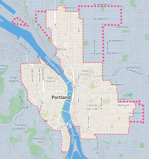
The changes, which will be officially announced later today, would expand the Biketown service area map by about 20 percent (two square miles) and remove fees for parking outside designated stations in large swaths of downtown (around Portland State University) and the Central Eastside. In addition, PBOT wants to add nine new station locations and remove seven existing ones.
All the expansions come at essentially no cost to the public because there are no plans to add new bikes or additional infrastructure to the system.
We talked all about it this morning with PBOT Operations Manager (and Biketown guy) Steve Hoyt-McBeth. Here’s what’s in store…
‘Community Stations’ coming to Killingsworth and Alberta corridors
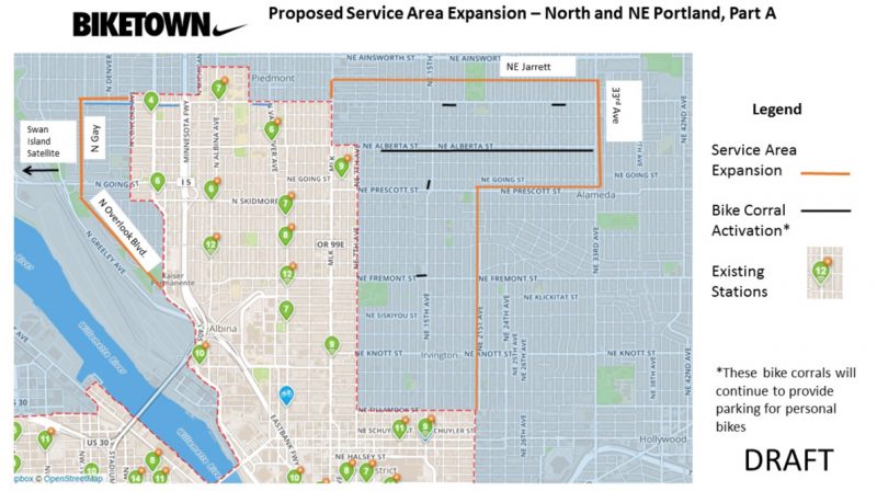
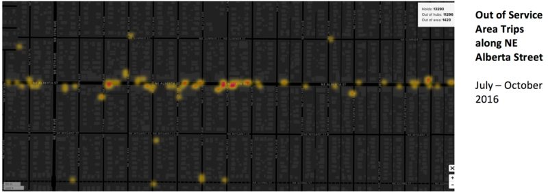
PBOT’s new proposal would turn existing bike corrals into “Community Stations” that would act as both Biketown and private bicycle parking. Because Biketown uses “smart bikes” (all the technology for renting one is on-board and there’s no large kiosk necessary), the system is flexible and the bikes can be parked anywhere. This means the service map isn’t dictated solely by the presence of official stations. All PBOT has to do is draw a new boundary in the “geofence” that tells their system whether or not a bike is parked outside of it.
Customers who end a trip outside the service area are charged a $20 fee. It’s those kind of trips that encouraged PBOT to expand east on Alberta. “Alberta has the highest concentraion of out-of-service-area trips,” says Hoyt-McBeth, “What we’re trying to do is utlitize and leverage the flexibility of the smart bikes along with our robust bike parking infrastructure and investment.”
It helps that the local business association, Alberta Main Street, strongly supports the plan.
For those worried that precious bike parking spaces will be taken over by the bright orange public bikes, Hoyt-McBeth said PBOT’s goal will be for every bike corral to maintain two-thirds parking availability for private bikes. In a related story, PBOT is working on a bike corral usage study that will help them make better decisions about parking use.
In total, five bike corrals on Killingsworth between NE 33rd and North Gay and nine corrals on Alberta between NE 7th and 33rd will become community stations. PBOT will also use corrals on NE 15th at Prescott and Fremont for the new hybrid stations.
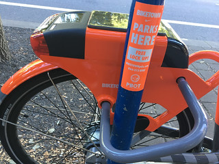
For Biketown to work, PBOT must make it visible. Stations are good at that. Without them, users don’t get the visual cues or confidence they need to use the service. To that end, PBOT says they’re looking into branding the bike corrals. They’re likely to use orange stickers and/or pavement markings.
A ‘Swan Island Satellite’
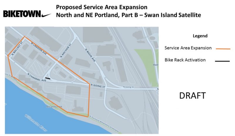
In what will be the only part of the Biketown service area map that’s not contiguous, PBOT will open a satellite zone on Swan Island. Hoyt-McBeth said the move comes after Daimler Trucks North America approached PBOT. The plan is to seed a relatively small area near Daimler’s main buildings (bordered by the Willamette River, Lagoon Avenue, and Ballast Street) with Biketown bikes. Hoyt-McBeth said they’ll add “probably no more than 10” bikes to the area to see how it goes at first. Daimler has agreed to promote Biketown among its employees.
Once the satellite zone is live, users can park bike share bikes at existing bike racks on the Daimler campus and at a nearby TriMet stop.
Hoyt-McBeth sees the Swan Island expansion as a way to reach Daimler employees going between meetings and as a way to make Biketown a more appealing option for people who work on Swan Island and live along the Interstate corridor (which is, a very low-performing area in the Biketown system).
Advertisement
‘Super Hub Zones’ are already live
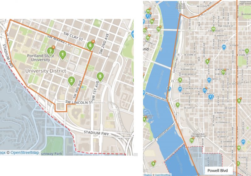
Another way PBOT is leveraging the flexibility of the system is with the creation of “Super Hub Zones.” Encompassing the entire Central Eastside Inudstrial District (from I-84 to 12th Avenue and south to Powell Blvd) and a large area around Portland State University, Biketown users will be able to park at any existing public bike rack without the typical $2 out-of-station charge.
The eastside zone (which has 550 public bike racks in it) is supported by the Central Eastside Industrial District (CEID) and the downtown zone (that has some of the highest bike usage anywhere in Portland) was first requested by PSU as a way to encourage more Biketown use among students.
“It’s like having one big station, a pure, smart-bike system,” Hoyt-McBeth said. The zones are already turned on, so have at it!
The Southeast Expansion
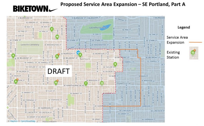
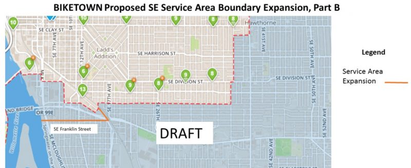
Hoyt-McBeth described the southeast expansions as “more discreet” than the ones in northeast. The new service map will go to SE 43rd and (mostly) 44th along SE Alder and Harrison in order to service the Belmont and Hawthorne commercial corridors east of Calle Cesar Chavez. In a separate expansion, PBOT is proposing to extend the southern boundary to SE Franklin Street between McLoughlin and 13th – 17th. That extension would loop in a key part of the Brooklyn Neighborhood’s commercial corridor on SE Milwaukie (including the Alladin Theater, where PBOT often sees out-of-station activity).
Station removals and relocations
Also part of the proposed changes are nine new stations and the removal of seven others. Here are the new locations:
• N Russell at Williams (social services)
• NW Pettygrove at 14th (affordable housing)
• NE Couch at 3rd (affordable housing)
• NE Schuyler at 2nd Avenue
• SE 8th at Main
• SE 43rd at Belmont Avenue commercial node
• SE 40th at Hawthorne
• SW Naito at Morrison
• SW Moody/Bond and SW Lowell/Bancroft (affordable housing)
And based on an analysis of ridership, equity, cell connectivity, staff safety, accessibility, solar access, constituent feedback and lost meter revenue, PBOT will “relocate” (a.k.a. remove) the following stations:
• N Interstate at Willamette – [This station is ranked 100 out of 100. PBOT says the expanded service area on Killingsworth will make up for this lost access.] interstate and willamette
• NW 23rd at Savier
• SE 29th Avenue at Stark
• SE Ankeny at 28th Avenue (This station was temporarily removed due to construction, this makes it permanent. BIKETOWN has activated two bike corrals, SE 28th and Couch and SE 28th at Pine in the interim. PBOT is considering making it permanent.)
• SE 37th at Hawthorne
• SE Taylor at Cesar Chavez
• SW 11th at Main
Biketown’s ‘long-term vision’
All these changes reflect the confidence PBOT and Motivate (the system’s operator) have in Biketown. It’s also a sign that PBOT isn’t afraid to push the boundaries (literally) of what a smart-bike system is capable of. Without having to make a big investment in bikes and kiosks, PBOT thinks they can get higher utilization of each existing bike (a key metric of a system’s success) by making these relatively small operational and geographic tweaks.
The potential risk is that the expanded area results in fewer bikes available overall. The density of stations and bikes is one of the top factors that determines whether a bike share system succeeds or fails. Asked why they don’t just add more bikes to the system, Hoyt-McBeth said he’d love to, but they don’t have the funds right now. “And our utilization rate,” he added, “is at a place where we feel there’s capacity to expand.” PBOT also feels like they’re over-the-hump in terms of public understanding of the system and their own ability to operate it well.
Now is the right time, Hoyt McBeth feels, to take advantage of the system’s inherent flexiblity. “This is part of our long-term vision for choosing a smart bike system.”
What wasn’t part of Portland’s long term vision was the flood of smart-bikes that are taking over cities in China. At the Bicycle Advisory Committee meeting last month, Hoyt-McBeth acknowledged that bike share competitors (like Ofo) oare likely to test Portland waters eventually. By making these expansions now, he hopes Biketown can stave them off. “This makes our market a little less attractive to those competitors,” he said.
To comment on these changes, PBOT has put together an online survey. They’re taking feedback until May 19th, at which time PBOT Director Leah Treat will make the final decision to move forward.
— Jonathan Maus: (503) 706-8804, @jonathan_maus on Twitter and jonathan@bikeportland.org
BikePortland is supported by the community (that means you!). Please become a subscriber or make a donation today.



Thanks for reading.
BikePortland has served this community with independent community journalism since 2005. We rely on subscriptions from readers like you to survive. Your financial support is vital in keeping this valuable resource alive and well.
Please subscribe today to strengthen and expand our work.
Nothing for John’s Landing or SW?
They’re adding the station further south. It’ll be interesting to see how it compares to the station by the Tram, which is one of the most oft-used.
This is just what I was hoping for, a systematic yearly expansion by demand. I’m still about one mile outside the zone, but it is inching towards me. A 20% gain in total area (although it seems like some thinning inside the map w/ removal of lightly used station) is solid in my book.
Super disappointed they didn’t expand south of Powell to the Catholic Charities immigrant/refugee community area. There’s a new, safe crossing going in on the new SE 28th Greenway right there at Powell. This also happens to be where Catholic Charities housing complexes are located.
I mentioned this in my response to the survey (specifically cited the new, safer crossing of Powell, which was a major concern during the initial service area planning); if a number of other people do the same, it will move this up the “expansion possibility” list quickly.
Done!
Came here to advocate for saying it “bikeytown.”
Would love to see a station closer to work for me. Although I ride my bike to work a lot, if I go somewhere for lunch I generally don’t like riding my own bike there for a few different reasons. It would be great to be able to hop on a Biketown bike to grab lunch, so I could go somewhere outside of normal walking distance and not have to worry about parking either.
With around 1500 employees and a decent amount of bars/restaurants relatively close (but further than a lot of people want to walk) I bet a station right next to us would get a lot of use. I wonder if the company could work with Biketown to do this? I also wonder if there’s a way where a business could work with Biketown to get some discounted memberships (with the business paying the difference)? Seems like it would be a fairly cheap way to possibly reduce health insurance costs and show that you actually care about employee health (as well as the benefit of physically active workers being more productive).
AFAIK PBOT is ALWAYS looking for corporate partners that would be willing to help expand the system. They’re obviously most interested in 5- or 6-figure sponsorships, but they may also welcome partnerships of just enough money to cover a new station, or a few more bikes to help justify expanding the zone a few blocks.
Ryan, where might that location/employer be that you’re discussing?
Fred Meyer corporate office, between SE 22nd and 26th off of Powell.
Still no love for Foster-Powell, huh?
Apparently if you can successfully trick a bunch of tourists to park their Biketowns in FoPo (paying the $20 to do so), you’ll get your expansion.
Foster Powell? They still haven’t even reached the neighborhoods west of Foster Powell.
Disappointed with prioritizing N and NE over SE.
“All the expansions come at essentially no cost to the public because there are no plans to add new bikes or additional infrastructure to the system. ”
???
Isnt this called diluting the existing system?
The bikes are currently only seeing about 1-2 rides a day on average. Also if you look at the Biketown map at any given time, you can see that it is extremely unusual for a station to be completely cleared out of bikes. These both indicate too many bikes for the current service area, and support a service area expansion for optimal performance.
I frequently see orange bikes in Sellwood being ridden around, and up and down the springwater from there.
Yes, not having any stations in Sellwood (near one of the busiest bikeways in the city) seems silly.
Although it’s still a bit to get to my neighborhood, I’m pretty happy to see these adjustments. I think it’s going to do very well on Alberta and the idea that there are large zones where you won’t get dinged for not using a specific station makes it a lot more appealing to me when I am in the service area. There could be a bit of confusion on that (where are the boundaries where i pay that penalty vs not), but overall I think operational adjustments to drive up per bike usage is a smart plan and hopefully leads to more investment in building the system (additional bikes and service area) down the road. Also intrigued to see how that Daimler partnership works out. My gut is there are employees down there in Swan Island who will take advantage of this, should be interesting to see how much heavy lifting the company does to make sure its a success!
I hope the City steps up by fixing some of the gaps in the bike network that may be suppressing ridership. For instance, The people in North Portland do not have a safe way to cross the many arterials to access the Alberta Commercial strip and vice versa. The logical route for connecting the bike network is Skidmore. Skidmore already has a safe, buffered lane over I-5. If the buffered bike lanes were extended west, there would safe, signalized crossings at Vancouver, Williams, and MLK in addition to the signal at Interstate and the 4-way stop at Mississippi and NE 7th. Skidmore connects the Concord Greenway, The Michigan Greenway and the Going Greenway as well as the bike lanes on Interstate, Vancouver and Williams and the planned 7th Ave Greenway and planned Sullivan’s Bridge. Without a safe, easy connection across I-5, Vancouver, Williams and MLK, north Portland is a bit isolated and the pretty good bike infrastructure cannot function like a real network.
Overall, this seems pretty solid. I am a *little* concerned about 20% more service area and 0% more bikes, but in my experience, there has literally always been at least 5-6 bikes at a given station when I need one, so if that number dips 20% to 3-4 bikes, I suppose that’s a reasonable price to pay for a larger service area.
I have not figured out why Biketown never looked northwards of their current boundries. Ainesworth has been a bike highway for the last 40-50 years for east-west to connect across I-5 from NE 33rd ETC to the Willamette bikeway.
We should expand to the Fred Meyer and New Seasons on Broadway… Here’s a pic of what I envision: https://drive.google.com/open?id=0B8oExQx5u0lZdnhJLVpSU3FpUU0
Agree. I was hoping it would go all the way to Hollywood.
If you’d like to learn more about the station changes in SE and provide input, Steve Hoyt-McBeth (PBOT) will be at the Sunnyside Neighborhood Association Land Use and Transportation Committee meeting tonight. The meeting is at 7pm at SE Uplift (3534 SE Main St).
Mostly just excited to see data-based decision making used to determine service area expansions.
Does the on-board [bike] screen warn riders that they have travelled outside of the service area?…for users not parking at a Biketown rack or have a smart phone with the app? The expansion and the marketing of more flexible (non-bike pod) parking may generate more users fines for parking outside the “zone”.
I was asking for the population that might not have a smart phone. My only similar experience was as a Car 2 Go user and their on-board system map had not been updated so I parked in a less desirable areas that i could have (to get to transit).
you don’t have to have a smart phone to use the system. You can just use a card, although smartphones can be helpful for finding the closest bike.
This looks great. When would the changes take place? This summer?
As a former Brooklynite, I’m glad to see the expansion across Powell to encompass the far north side of the neighborhood. No stations planned there, though?
Too bad the nearest low-income area to the service territory (around 26th & south of Powell) wasn’t included. Hopefully in the next expansion the service will be on solid financial footing and can afford to weight equity more heavily into the decision-making process.
I haven’t been reading or paying attention.. but is the path along the river to North Portland ever going to be a thing?
I think they are planning on building a shanty town there instead! Seriously, I think Right-to-Dream is being relocated to the former Thunderbird Hotel site, on the banks of the Willamette in front of the MODA Center. That is where the NP Greenway is planned to go.
R2D2 is a welcome neighbor to the Greenway (if it were to happen) for me. But tell me about this Thunderbird hotel–I’m only familiar with the old Jantzen Beach location that burned 5 years ago. There was one by the Moda Center?
Check out this great old image:
http://www.stumptownblogger.com/2011/06/memorial-coliseum-the-thunderbird-hotel.html
Also, a bit of backstory and some more great photos
https://fadedportland.wordpress.com/2016/08/05/rose-quarter-area-1977/
Maybe whole foods area?
Check out this great old image:
http://www.stumptownblogger.com/2011/06/memorial-coliseum-the-thunderbird-hotel.html
Also, a bit of backstory and some more great photos
https://fadedportland.wordpress.com/2016/08/05/rose-quarter-area-1977/
Just to be clear, the PBOT “Biketown guy” wants to stave off private competitors that might increase bike accessibility in Portland?
“At the Bicycle Advisory Committee meeting last month, Hoyt-McBeth acknowledged that bike share competitors (like Ofo) oare likely to test Portland waters eventually. By making these expansions now, he hopes Biketown can stave them off. “This makes our market a little less attractive to those competitors,” he said.”
Does Nuketown post trip data? Most bike share systems do.
Auto-correct- sorry. Trying to write bike town but the phone isn’t having it