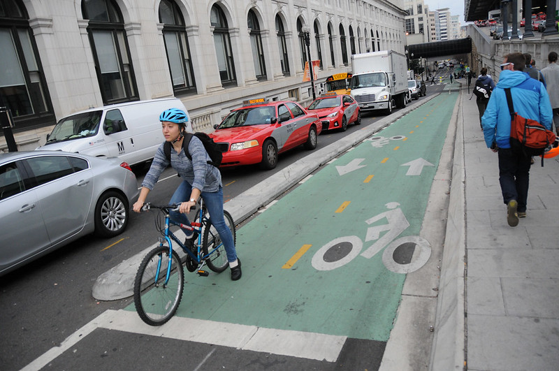
(Photos: J. Maus/BikePortland)
If it can happen in D.C., can it happen in Portland?
This spring the City of Portland will (finally!) embark on its Central City Multimodal project with an aim to create a network of protected bike lanes downtown. With that mind I joined a walking tour offered as part of the National Bike Summit this morning to take a closer look at one piece of the burgeoning bike network.
With about 16 miles of protected bike lanes already built in its downtown core, D.C. is well on its way to making a connected network that people can use to zip around on bikes with the same (if not better) ease and convenience as other modes. This morning’s tour focused on one project in particular: the protected bikeway on First Street NE.
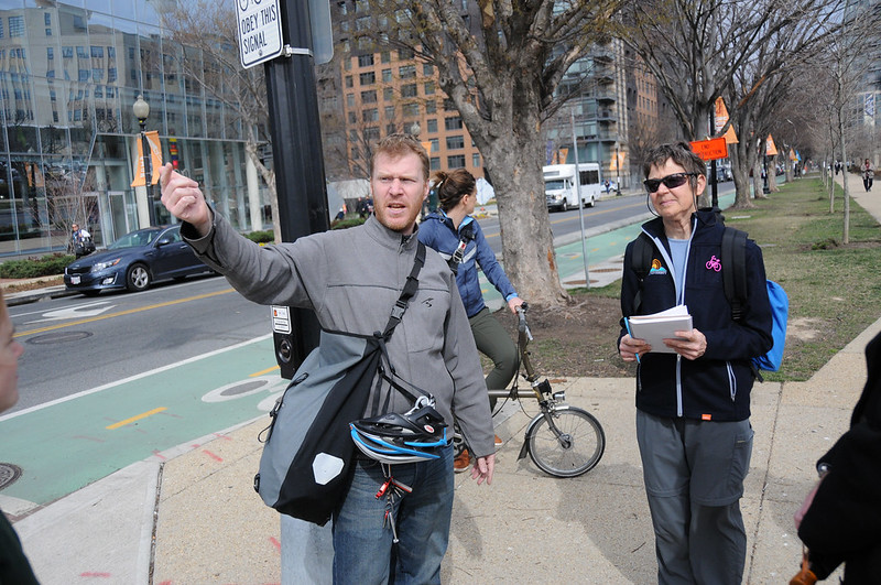
The tour included insights from local experts including: District Department of Transportation Bicycle and Pedestrian Coordinator Darren Buck; NOMA Business Improvement District (BID) Planning & Economic Development Director Galin Brooks, and Washington Area Bicyclists Assocation Executive Director Greg Billing.
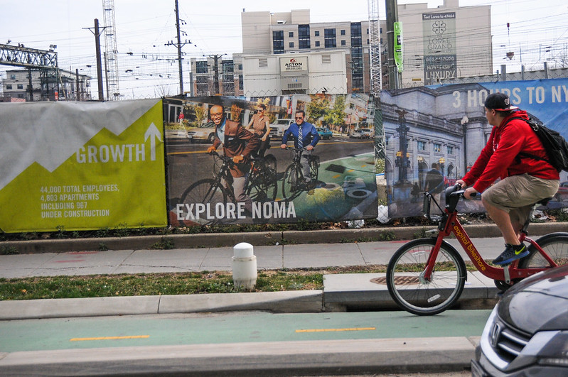
The First Street project, completed in 2015, created a bikeway from Union Station north to M St. It goes through the growing “NOMA” neighborhood (North of Massachusetts) and connects to the Met Branch Trail (a paved multi-use path similar to the Springwater Corridor).
The NOMA area reminded me a bit of Portland’s Pearl District. Extending for about one mile north of Union Station, it’s a new mixed-use neighborhood that has sprung up in a former industrial area. Hundreds of row-houses were demolished to make room for rail lines in the early 1900s when Union Station was built. As train lines vanished with the onset of highways in the second half of the 20th century, warehouses and factories sprung up in their place.
“These blocks became desolate in the 1980s,” Brooks described during the walking tour this morning. In the past decade the amount of developed square footage tripled from six million square-feet to 18 million square-feet. With that growth, the biggest change is that much of that development is residential.
Since D.C. has relatively good (for the United States) transit options (including one of the nation’s best bike share systems), a large majority of NOMA residents live without a car. Brooks said 80 percent of of them either walk, take transit, or use a bike to get around.
Advertisement
Because of this high non-driving mode share, business owners in the NOMA area have been very amenable to reconfiguring streets with improved access for bicycle users. “They just get it,” Brooks said.
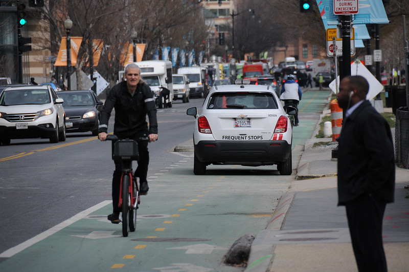
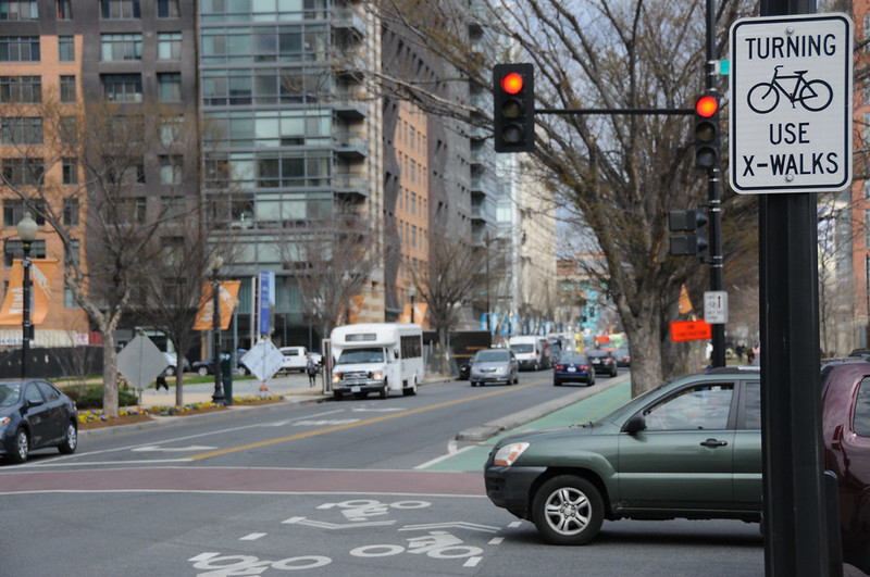
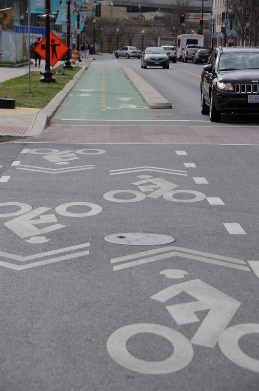
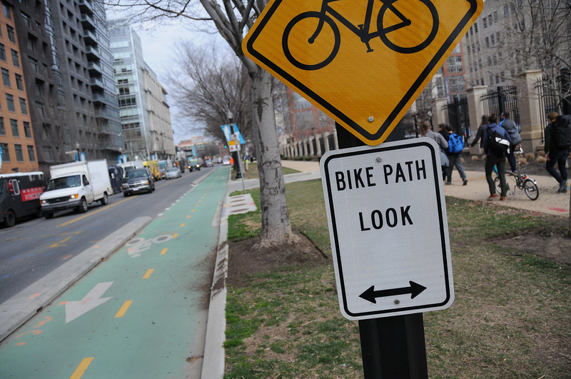
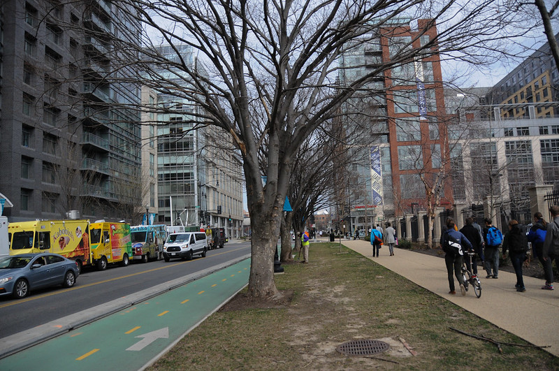
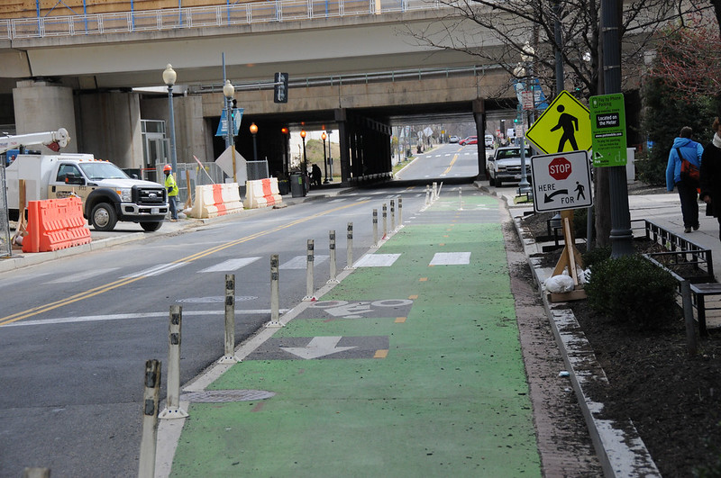
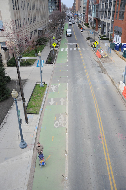
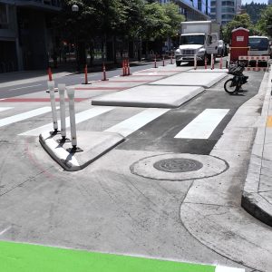
As a result, DDOT was able to re-allocate 10-13 feet of road space on First St NE for 0.6 miles for the exclusive use of bicycles. The design is a two-way, green-colored bikeway with five-foot wide lanes and varying degrees of separation throughout.
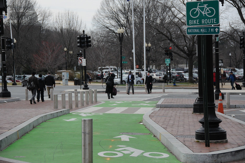
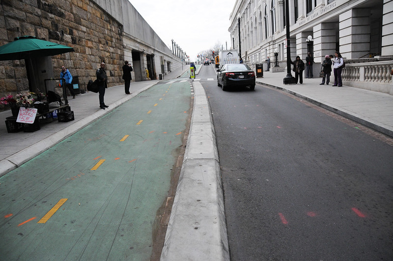
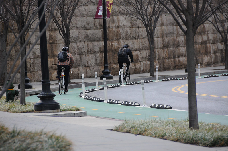
For the portion near Union Station, DDOT traded a standard northbound vehicle lane and bike lane to make room for the two-way facility. In that section there’s a three-foot concrete median between bicycle and auto users. In other sections the bikeway is separated by rubber curbs and flex-posts. In another section — where there’s a new building being built — there’s nothing but paint.
Darren Buck with DDOT said the main reason they opted for a two-way facility on one side of the street (instead of protected bike lanes on each side) was because there are no driveways on a large segment. And since a key impetus of the project was getting people to the Met Branch Trail, they figured it would be easier to connect bike traffic if it was only on one side of the street.
That connection to the Met Branch path helped spur the First St. project; but it initially left a one-block gap. Once people started using the protected bike lanes — up to 1,500 a day during the summer, according to WABA’s Greg Billing — a glaring gap on M Street emerged.
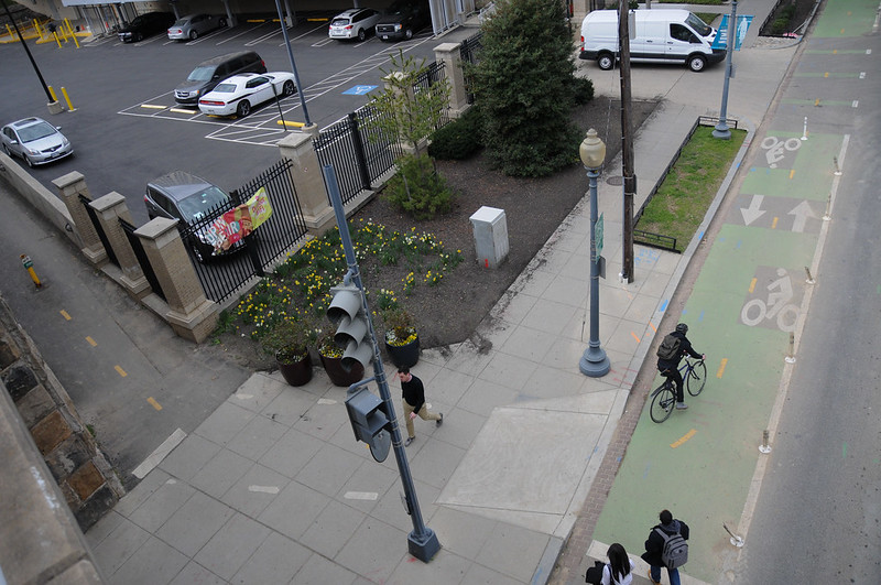
As we walked along the continuation of the bikeway that exists today in that former gap on M Street, DDOT’s Darren Buck said its contruction, “Came together rather quickly.” Why? “The community wanted it,” he said. And the protected bike lane on NE 1st, he added, “Sort of revealed the need for it.”
That’s the power of making bike access upgrades. Once you get them started and installed, people will expect — and then demand — more of them.
— Jonathan Maus: (503) 706-8804, @jonathan_maus on Twitter and jonathan@bikeportland.org
BikePortland is supported by the community (that means you!). Please become a subscriber or make a donation today.


Thanks for reading.
BikePortland has served this community with independent community journalism since 2005. We rely on subscriptions from readers like you to survive. Your financial support is vital in keeping this valuable resource alive and well.
Please subscribe today to strengthen and expand our work.
Thanks for the update. Based on the photographs I have a question. One photo has a fairly official sign that reads “TURNING [bicycle symbol] USE X-WALKS.” Within the District, are bicycles prevented from executing a left turn from the travel lanes if cycletracks are present? Basically, are “Copenhagen lefts” mandated by local ordinance when an appropriate bike facility is present or are all methods of turn permitted and the only limit is that of the user’s comfort and experience level?
When I was biking there last October, the bike messengers were making left-turns like cars, but folks riding bike share bikes were using the pedestrian signals, many of which have 60-second countdowns. Not sure about the actual local laws, though.
Encouraging bicyclists to use crosswalks is not a “Copenhagen left”, it’s a poor substitute that harms the pedestrian experience, particularly in a pedestrian heavy city like DC. A true Copenhagen left provides enough room between the crosswalk and roadway to allow turning bicyclists to wait without getting in the way of other bicyclists or pedestrians. I’m disappointed to see DC formalizing an the “use crosswalk” approach.
It is fairly complicated to design for bicycle circulation out of a two-way bike lane, particularly from a constrained design without much buffer from the roadway. This is one of the reasons you generally won’t find bidirectional facilities on roads in Denmark.
In general, the new generation of protected bike lanes use more robust separation methods such as curbs, or a raised lane. These may not allow easy exit from the bike lane, effectively limiting your options for making a left turn.
Nice to see the DDoT progress in DC especially next to the DC Bikestation.
For those too young to remember cycling in the late 80s/90s/…DC was known more for the poor state of their pavement (lots o’potholes) for cycling and not innovative bikeways.
Love how visible lanes are. Hard to not know they are there. DOTs have a responsibility to not only make bike infrastructure but also market it if they want to change mode share. Making it this visible is a great way to do that. Now we just need a bike that can help clean the lanes and keep them looking fresh.
One thing I notice in those pictures of DC is that the pavement is in a whole lot better shape than it is in PDX, and they use storm drain inlets inset into the curb rather than the double-wide in-street drains that Portland uses. These may be small details but they are critical to the success of a network like this.
Michigan Ave NE needs help. I lived in a home on that car-dominated street.
Oh my goodness…look at that congestion! Widen that street to 4 lanes..stat! Wait, is that freight in congestion! Ok..10 lanes..mow down the buildings…we need more lanes!
The area around Union Station is less busy on traffic. M Street on the other hand…
awesome design, but makes me wonder if some drivers in PDX would still drive in bike buffer. * downtown struggles these days *
Very cool. What’s with the one narrow chokepoint in the penultimate photo? Seems like they created a spot for that van to partially pull over and load, but it’s not enough for it to get out of the vehicle lane, so why bother?
i didn’t ask about it Gary B. I’d assume it was a compromise with the building owner to give them better access to their main entrance.
Neither. It’s to allow semi trucks and other large vehicles to turn out of the loading dock at the building across the street. It just happens to be used by the (unnecessary) shuttle service to/from Union Station to a building that is quite literally half a block from a Metrorail station, one stop from the commuter trains at Union station.
I started to come to DC in 2009 occasionally and then lived there between 2011 and 2013. It was amazing to see in real time how the city built more bike infrastructure during that time pretty quickly and how the bikeshare increased bike ridership. When I moved to Portland I was surprised by the lack of good infrastructure, the bad state of roads and the glacial pace with which things seem to move forward here.
Welcome to Federal funding. National capitals always have better infrastructure than provincial commercial cities like Portland. Ottawa vs Kitchner, Amsterdam vs Rotterdam, London vs Birmingham, Copenhagen vs Odense, etc.
Tell that to MetroRail!
HILARIOUS.
That’s not true for the Netherlands. Amsterdam, while the most well-known and indeed very bike friendly, is arguably not the best cycling city in the country. There are quite a few cities and towns that have better bicycle infrastructure than the capital.
I’m comparing capitals to the next biggest cities, which tend to be industrial like Portland. We too have many towns with far better infrastructure per capita, but they tend to be small college towns of under 200,000 with mostly white and well-educated populations.
You are probably right with all the other examples. I’m speaking only in the context of the Netherlands, where I currently live. Amsterdam on its own would rank as one of the most bike-friendly cities in the world. But there are many smaller cities here that are even better in my experience. Overall, the cycling infrastructure is very developed throughout the entire country, but there are noticeable differences in quality that appear to be based more on regional/provincial policies than city or population size.
My impression is that, aside from a few bicycle blogs that occasionally write about them, most of these cities are not well known to much of the world (Utrecht, Tilburg, Den Bosch, Groningen, Nijmegen, Zwolle, etc.). Which is a shame, because there is often confusion as to whether Denmark is more bike friendly or the Netherlands, when in fact these conclusions are based solely on comparing Copenhagen with Amsterdam. Having also spent considerable time cycling in Copenhagen, I will say that the conditions for cycling are inferior to the Dutch cities. But the marketing of Copenhagen has apparently been so successful that even many of my Dutch colleagues are under the impression that it is the most bike-friendly city in the world.
I’ve never been to Copenhagen, so I’m in no position to compare it with anywhere else. However, I have traveled extensively in the Netherlands (20 towns), Belgium, Britain, and Germany over the years, as well as parts of Ireland, Italy, Switzerland and France. In general, I find that any large “college town” in any of these countries has far better bicycling infrastructure and heavy use than their respective capitals. For example, Brugge or Gent vs Brussels; Amersfoort or Leiden vs Amsterdam & Den Haag; Trier or Dresden vs any of Germany’s 4 official capitals (Bonn, Frankfurt, Karlsrue, & Berlin – well, maybe not Bonn, it’s also a pretty bike-friendly university town); Lucca vs Rome; Cambridge or York vs Greater London (not just congestion-priced inner London, where only 8,000 people reside, but the 8 million person metro), etc. I also agree that many smaller cities are much less well-known to Americans unless they are bike or history buffs – One of the many treaties of Utrecht gave the US its independence from the UK in 1783. Nice city too, I was last there in 2013, along with the very un-Dutchlike city of Maastricht.
“Inner London”, as the term is normally used, has over 3 million people living it. The “City of London” may only have 8,000 people, but that’s a tiny part of Inner London that doesn’t even include London’s most iconic sights (Big Ben, Oxford Street, Tower Bridge, London Eye, etc).
To make this on-topic, bike infrastructure in London is nowhere near as good as it is in Continental Europe, but has come a long way in recent. I had the opportunity to try one of the Cycle Superhighways last September, and it was (for the most part) a joy to use. It was significantly better than anything that has been built in Portland to date.
Unless they’ve enacted a ban on ‘Muricans, perhaps you might investigate moving over there permanently.
I’ve noticed State capitols also seem to have the better roads as well.
I think most residents of the District would dispute any assertion that DC is better taken care of than cities in states with actual representation in Congress.
Q: Which cities of over 500,000 (3 million metro) in the US have better infrastructure than DC?
Portland?
Our “state” DOT (DDOT) gets the same formula funding that every state DOT does, and we supplement ours with the gas tax and occasional capital appropriations. But as an entirely urban jurisdiction, we just choose to spend ours differently.
I like the low concrete or rubber curbs, preferably with gaps, used as dividers. Effective at preventing casual car intrusion (try driving over a 4″ curb at 25 mph, you won’t do it twice), allows emergency vehicles to cross over when necessary (e.g. fire engine that needs to get close the building to deploy ladder), less expensive, permeable for cyclists wanting to cross the road.
Some days I wistfully recall the 5 years I spent there in the 90’s. Then I remember how bad the traffic was even back then and have no regrets about leaving the place.
Recently moved away from DC having lived there for about 2 years. While the infrastructure might LOOK good in the above photos, it is certainly not a fun or safe place to ride by and large. The first photo above shows the southern end of the PBL on 1st st NE (a decent design BTW), at which point you end up at Columbus, an 8 lane wide road that exemplifies DC’s streets. Keep in mind that it is illegal to ride your bike on the sidewalk in central DC.
https://www.google.com/maps/@38.8965816,-77.0077234,3a,75y,148.24h,74.76t/data=!3m6!1e1!3m4!1sYLL1_U1Biop2m_hViVs5tQ!2e0!7i13312!8i6656!5m1!1e3?hl=en&authuser=0
Bikeportland will likely show pictures of the median PBL on Pennsylvania Ave. West of the White House, this avenue remains 8 lanes wide with no median or bike infrastructure. Portland may not have PBLs, but West of 82nd it is one of the most walkable/bikable places I’ve lived. For most people walking and biking DC remains pretty awful.
Current DC resident and bike activist here. What you say is all true. However, the southern end of 1st St does link to door zone bike lanes on E Street, and there are active plans to build a protected bike lane on Louisiana Ave, which would link to the Mall and to the Pennsylvania Ave protected bike lane (which links directly to the 15th St protected bike lane, which links to the L & M protected bike lanes, and so forth). So, it’s getting to become a real network, although living here, it sometimes seems to be moving a a glacial pace.
http://www.waba.org/blog/2015/10/momentum-builds-for-louisiana-ave-protected-bike-lane/
Also, there are active plans for a protected bike lane on the section of Pennsylvania Ave (west of the White House) that you mention. Again, this link directly to thenetwork mentioned above.
https://ddot.dc.gov/page/downtown-west-transportation-planning-study
There are also active plans for a protected bike lane on either 6th or 9th Street between Pennsylvania Ave, north to around S St. Also a direct link to the existing network.
http://dccycletrack.com/
So you’re correct that there are gaps and crappy streets in DC where it sucks to bike, but there’s also a lot of progress in moving things forward.
Some kind of shuttle stop apparently
https://goo.gl/maps/geyVVSmV3XT2
When a lane for bikes is too narrow for the standard bike stencil, it’s too narrow. Also, who thought it was a good idea to put wands on the inside of a narrow curve?
I’m not terribly impressed with the “success” of the projects to date. DC has been stuck at 4% since 2012, a plateau similar to PDX recent experience but at an even lower level. It’s better than the backwards trends I’m seeing in some places in recent years(Eugene, Davis, Sacramento), but hardly something to write home about.
It’s great to see what other cities are doing. I’m looking forward to seeing what comes out of our (long overdue) Central City Multimodal project.
Sorry to nitpick but where’d you get this 16 miles of protected bike lanes figure? Seems like you’re combining what pitiful protected bike lanes we have with our off-street trails (Metropolitan Branch, Capital Crescent, Anacostia Riverwalk, and Rock Creek Park trails) which paints an inaccurate picture of DC’s bike friendliness.
In reality, DC is very bicycle unfriendly, or at least the political leadership is. The current and previous mayoral administrations pay lip service to bicycling and Vision Zero and all that good stuff, and then instruct their transportation departments to water-down, postpone, weaken, and cancel bicycle and traffic-calming projects.
Case in point, current Mayor Bowser, reacting to criticism and backlash over a proposed bike lane in the eastern part of downtown, ordered the District Department of Transportation (DDOT) to “study” the potential options for over a year. They just released a 100-page (!) report on the project and…they still don’t have a design chosen. And the two remaining are not at all considered best-practice infrastructure. And it won’t be built until at least 2018. We’ve seen this movie before and I will not at all be surprised if this ends up being pushed until after election day. http://wamu.org/story/16/12/19/controversial-bike-lane-project-shaw-pushed-back-2018/
https://ggwash.org/view/62411/a-protected-bikeway-may-run-down-6th-or-9th-street-nw.-but-it-also-might-no
DC is a beautiful, wonderful city that I’m proud to call home. They have done some great stuff with bikes over the years and it has truly great potential for the future, but don’t be fooled!
I got that figure from Darren Buck at DDOT. He said DC has 8 centerline miles of protected bikeways…. which I prefer to state as 16 miles of protected bike lanes.
Thanks so much for sharing Dutchie. I think the story of 6th NW exemplifies how DC govt works re safe streets. There are a few more instances of DDOT completing research, and subsequently not following its own recommendations. (Albemarle St was another good example). I lived near 6th NW for a while. I moved away because of how dangerous (as evidenced by DDOT’s numbers in the WAMU story) it was to walk and bike despite the high number of people cycling based on DDOT’s numbers.
Keep in mind DC and VA has some of the best trails outside of the central city. Capital Crescent, Mt. Vernon to name a couple. But Dutchie’s correct. Don’t be fooled by a few well-designed, isolated PBLs.
While I get frustrated by DC inaction sometimes too, when compared to the seemingly random & disjointed protected bike lanes installed in NYC, the situation in DC is far superior and there has been steady progress. Almost every single protected lane in the works connects directly to other protected lanes. Yes, there’s a lot we can do better. The design often is lacking (due to a lack of political leadership), but there has been steady progress over time, across a number of administrations. Also, there are a BUNCH of PBLs either recently opened, under construction, or in the planning/design phase.
15th St extension + ped islands & bioswale just opened & then was extended up the hill:
https://twitter.com/SustainDC/status/777222338114969600
http://www.waba.org/blog/tag/15th-street-protected-bike-lane/
A new bike-ped only path, replacing a washed out road in Rock Creek Park in under construction:
http://www.klinglevalleytrail.com/
DDOT recently installed protected bike lanes (and road diet) on Klingle, leading to the new path
https://twitter.com/J_uptown/status/787350038716506112
The Shared use path in Rock Creek Park is getting upgraded & widened as we speak:
https://www.nps.gov/rocr/learn/management/beach-drive-rehabilitation.htm
A plan for an East-West cycle track connecting Columbia Heights & Brookland
http://dccrosstownstudy.com/studyinformation/
Plans for PBLs on Pennsylvania Ave west of the the White House, on NY Ave, on 6th/9th St, and on FLorida Ave are all underway:
https://ddot.dc.gov/page/downtown-west-transportation-planning-study
https://ggwash.org/view/62617/new-york-ave-ne-might-get-a-bike-trail-or-protected-bikeway
http://dccycletrack.com/
http://www.thewashcycle.com/2017/02/florida-avenue-30-design-includes-a-protected-bike-lane-from-3rd-to-west-virginia.html
There are NPS plans to extend the 15th St cycle track to the 14th St bridge (and much much more!).
http://www.thewashcycle.com/2016/05/national-park-service-updates-1990-plan-identifies-top-priorities.html
I’m leaving stuff out (the various PBLs recently implemented in suburban downtowns, the MET branch connections with new PBLs, everything in Arlington, etc.). So yeah, a lot of biking in DC still sucks, but a LOT of stuff is getting better pretty quickly.
Thanks for the update. Also, to be clear my purpose in commenting was not to poo poo DC. Rather, it was to show a discrepancy between the perception of biking/walking and the reality of DCs streets. Portland is also no stranger to a discrepancy between outside perception of bike friendliness and the hard reality of lack of infrastructure.
I would love to visit DC again and see these lanes in. Thanks for all the links. I would also add the relatively new Anacostia Riverwalk Trail segment in DC (one of my favorites along with the Towpath), which I believe should be open by now.
Oh man, the new Anacostia Riverwalk section is awesome! Highly recommended!!
The numerous sharrows across crosswalks remind me of YouTube videos from Paris, France, where they handle bike crosswalk markings in much the same way. Plans are on the table, I understand, to connect the C&O/GAP Trail from Pittsburgh to the East Coast Greenway on the National Mall somewhere. (The C&O/GAP currently ends in Georgetown in NW DC.) The rubberized separation is something I like, but yellow and black would be easier to see than black and white. The visible green paint and frequent street markings is a great idea.
I am not a fan of conta-flow bike lanes. These examples make work OK- it was hard to tell the context. In Portland this treatment has been proposed for dense areas. With our small street grid, this creates frequent intersections. Having 2-way bike traffic at every intersection is a recipe for disaster, IMO.
Wow, that’s a lot of green paint. Let’s see how it looks 4 years from now.