
(Photos: J. Maus/BikePortland)
A construction project on the west side of the Willamette River just south of the South Waterfront district has closed the Greenway path and the City of Portland has offered no official detour.
Crews from Fore Construction are building the Sanctuary Apartments at 4800 SW Landing Drive. A notice distributed by the company last week said work on the apartments will include the rebuilding and resurfacing of the Willamette Greenway path and the path will be closed through December 14th.
Fore’s statement said, “We will endeavor to keep as much of the trail open as possible during this period.” There was no specific timeline for when the path would be fully closed or open during construction and no detour map was provided with the company statement. We asked Fore and the Portland Parks & Recreation bureau what bicycle riders should do when the path is closed.
We heard back from PP&R’s Community Engagement and Public Involvement Manager Elizabeth Kennedy-Wong. She said, “There is no viable detour for this project – the immediately adjacent property is private, Macadam is not where we would put bikes.” Kennedy-Wong said the bureau “hopes” that people will simply avoid the Greenway path and opt for the Springwater path on the east side of the river while using the Tilikum or Sellwood Bridges to avoid the closure.
Advertisement
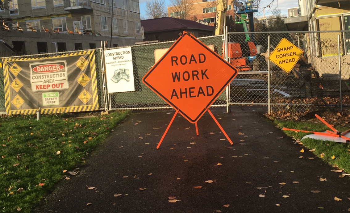
I scoped out the situation yesterday and found that the path was fully closed. There was a sign (see above) but it said only “find an alternate route” and offered no detour or signage to get around. The issue here is the best path around the construction is through private property (residential), so the City of Portland isn’t allowed to tell people to use it. So, what should you do? Here are some suggestions:
If you’re headed southbound from the South Waterfront district, take the path from Bancroft and continue south onto Moody. Then go right (west) on SW Hamilton Court and take the first left onto SW Landing Drive. Then take another left onto SW Landing Square, which will drop you back onto the Greenway path near the boat docks. Do this route in reverse if you are heading northbound. I made a map below:
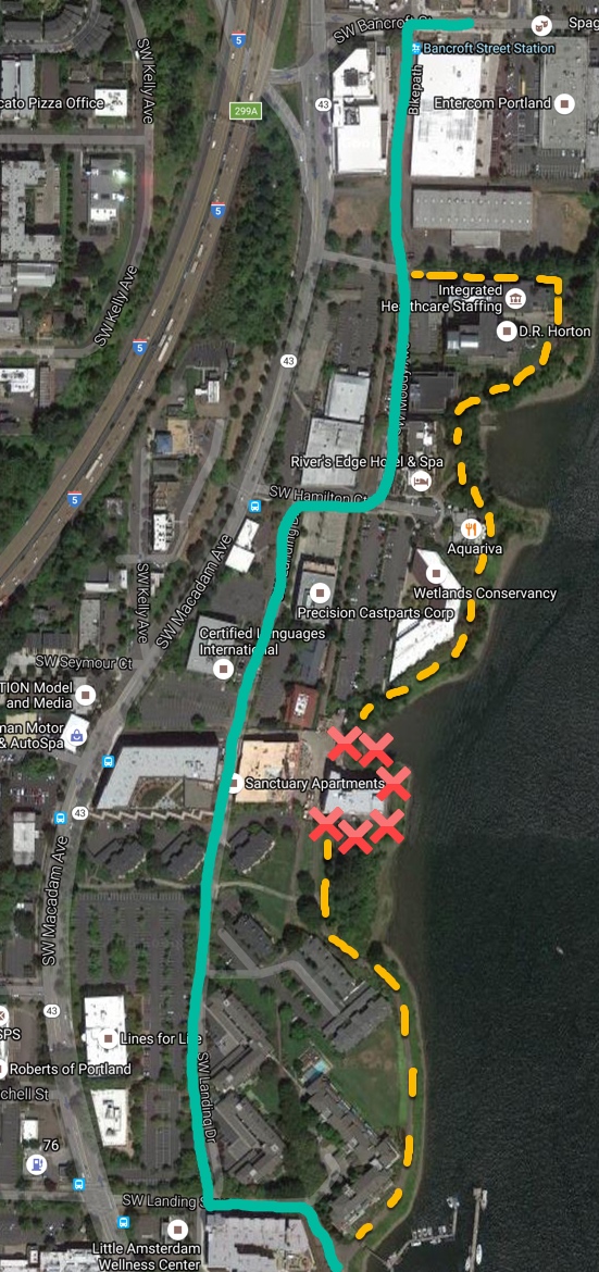
Red: Closure
Yellow: Greenway path
(Graphic: BikePortland)
Hopefully this inconvenience is worth it when the path re-opens with a smoother surface and more direct connection. Stay tuned.
(Please share your experience with this closure in the comments.)
UPDATE, 01/02/16: The path is still closed. The business manager for the company in charge of the project says the path closure will last longer than expected. In an email to a BikePortland reader on 12/30/16, Mackenzie Allaert of Fore Property Company said, “Due to the unexpected weather, the work that needed to be complete was delayed. After speaking with the construction team this morning, they have assured me they are working diligently to complete the work. They are anticipating being able to reopen the trail on January 9th.”
— Jonathan Maus, (503) 706-8804 – jonathan@bikeportland.org
BikePortland is supported by the community (that means you!). Please become a subscriber or make a donation today.


Thanks for reading.
BikePortland has served this community with independent community journalism since 2005. We rely on subscriptions from readers like you to survive. Your financial support is vital in keeping this valuable resource alive and well.
Please subscribe today to strengthen and expand our work.
Thanks for a map
Hope maps become a more common feature in articles discussing places!
Would PBOT close an auto route without identifying a detour?
Nope. Their recent map for the big Terwilliger sewer construction project doesn’t readily show the Terwilliger bike path even though two established bike shops are in nearby downtown Lake Oswego.
They’re closing Terwilliger with no good alternatives (notice the good qualifier), most people will end up on 43 or Boones Ferry because those are the only two nearby routes. It will be interesting to see if the impact on traffic, especially near the Sellwood, is catastrophic.
I think the auto traffic will become lighter on Terwilliger by Riverdale High School.
Probably. Unless most people opt for Boones Ferry, then it will be mostly the same. We’ll know in a week.
No, they wouldn’t, but I assume Parks is the agency the easement was granted to and not PBOT.
Would parks close a basketball court or dog park without first setting up a temporary alternative?
Yes
Parks DID just close the same regional trail (at Willamette Park) for about a month without setting up an alternative, at least a reasonable one. The detour was riding and walking on the grass, which turned into a mudpit after the first 2 or 3 days. And no work was done for much of that time.
Whenever I have to go that way, I always take the suggested detour route anyway. The bike path is too twisty, too narrow in parts, you have to share with pedestrians/dog walkers, and it is extremely ridden with bumps especially north of the construction zone. There’s almost no car traffic on SW Landing/Moody and you can just zip through.
I might try that next time. That greenway trail has many bumps. Past time for a trolley trail.
I crashed hitting one of those bumps last year on my NE-to-Far Southwest commute. Since the new Sellwood opened, I have switched to going down the Springwater and then across the new bridge. It is more than a mile longer in length but shaves five minutes off my commute. Best of all, no bumps!
trolley trail!
there’s a TriMet easement right through the middle of all that property that could be turned into a bike path… although they’re probably saving it for light-rail…
That row gets to just 17 feet wide in at least one place per a Multnomah County document from the early 1990s.
Um, one big problem with the suggested detour – what if your trip does not go the whole length of the Willamette Greenway? Then the “suggestion” is to go a mile out of your way (across the river), then travel out of direction north/south, then travel unnecessarily extra BACK along the Willamette Greenway to make up for your out of direction travel. PBOT needs to wrest some measure of operational control of these important transportation routes from PP&R.
Sorry, I thought you were saying you take the Springwater instead, whoops! Reading comprehension…
Parks treats cycling as recreation so of course they don’t care about creating a detour for commuters.
Yep. I lived for many years a few blocks from that spot. I always took JM’s path (Landing Dr) just to avoid that awful hard left and narrow sidewalk on the north end (i.e., around Integrated Healthcare Staffing on JM’s map).
How does cutting over to Landing Dr. placing cyclists on private property. Is that a private road? If it is public, Landing Dr. seems like a reasonable detour that avoids Macadam and could have easily been signed as the official detour.
I don’t think Landing Drive is private. Could be wrong. Perhaps they didn’t feel comfy putting a detour through it because it has lots of parking lots and is full of people driving. It’s not a very nice cycling environment at all.
Landing Drive is a private street, which is jointly owned by the surrounding property owners. I assume (but don’t know for sure) that there is a public access easement on it.
According to Portlandmaps, it appears Landing Drive is private along with most of the “roads” between Macadam and the river.
As a onetime resident of Landing Drive, I believe that it is a private road (although it probably should not be). It is a decent detour, however, and is actually more direct than the path that is closed.
All that said, it should be illegal for anyone to close a right of way without first identifying reasonable and safe detours for all affected modes.
Also, although Landing Drive is private property, so is most of the bike path through that area. Although access is granted to the public, there are signs clearly indicating that the path is privately owned.
A lady on the Beaverton planning commission has also worked this year for a home builder. Bend the rules here, too?
I work in the office buildings around here so I mostly take the green detour route anyway. Not quite sure why there’s no detour marked for Landing Dr. I will say that the little detour jog on SW Hamilton Ct can be steep for some users, although it is short. Also want to point out that there’s also a little pathway just south of the red X’s marking the closed route that will take you back onto the greenway earlier than the indicated detour.
Hi TH,
Just FYI I didn’t want to encourage people to take that more direct path just south of the closure because it is signed as “private property.”
I used to live out there. I can verify that pretty much all of it is private. However, no one will hassle you for riding Landing — I doubt they’d even think of that.
The Greenway itself is private even though you can access it. One thing the condo board I used to serve on used to worry about is making sure everything was well maintained because they were concerned about people getting injured and then suing.
Just so you know what your range of motion is, you can contact the property managers about areas of the Greenway path that concern you, and report to the city any violations such as illegal tree cutting (which runs rampant).
When you contact them, spare the hysterics, hyperbole, and threats since anyone who deals with that sort of thing knows it’s coming from someone who won’t do anything or who will be totally ineffective.
That development is an eyesore! Why are they allowed to built it so close to the banks of the river?
I’d say the same thing about I-5.
Yes, but those new apartments are extremely close to native Black Cottonwood trees which have roots that crunch asphalt, sewer lines, and sidewalks.
It would be a pity if those buildings damaged auto habitat or scared cars off of I-5.
The same trail just got closed for a few weeks further south in Willamette Park when the trail was repaved, and the detour was just riding across the grass, which turned into a mud quagmire after a couple days. Then the detour became just riding on the gravel trail after the pavement was removed. It wouldn’t have been so bad, except that after the trail was dug up, the work stopped for a couple weeks.
I don’t think the City understands how many people use it, and for non-recreational use.
Yes ! This greenway has become much more busy after the Sellwood bridge became more “completed” earlier this year. It is great to see more people enjoying it.
I agree. I’m not a fan of the freeway feeling that’s been created for the several hundred yards north of the bridge, but having it open, and with a far better bridge design, is great.
Separately, speaking of the Sellwood Bridge project, that project was guilty of the same thing about placing a low priority on completing the path. The project actually opened the path just north of the bridge, then hours later announced that had been a mistake, then closed it for another 2 or 3 weeks. There was never any explanation of how they could have thought it was complete enough to open, then suddenly find it needed that much more work to make it safe to use.
#WorkZoneWTF
Once again, bikeportland shows the good and the bad. This trail is often used by people just wanting to breathe clean air.
It’s not like official detours can’t be done on private roads, you just have to get the owners of the road to agree to it. Up in Seattle this happened in October: a Burke-Gilman Trail detour was installed over what was otherwise a private parking lot, through a fence that’s otherwise closed. Shouldn’t be too hard for a bike path with sections already on private land, around construction on a property accessed exclusively by the same private road network! For such a project securing an appropriate bike and pedestrian detour could be a condition of the construction permit!
Jonathan’s mapped route on SW Landing Way is easy. I rode it both directions this morning. In some ways its more direct and even safer than the riverside route. Yeah, the contractor and the City could have been a whole lot more helpful with the signage but I fervently hope the cycling community is clever enough to adapt. Hey, didn’t we handle the old Sellwood Bridge and the construction project just fine?
Yeah, all 6-7% strong and fearless types and enthused and confident types of us deal OK. What about the other 93%, a good number of whom who don’t bike in part because of the difficulty of finding comfortable, direct, dependable routes?
“Macadam is not where we would put bikes.” as if PP&R has any say on that.
Does anyone know (I may have missed the answer somewhere above)–will the permanent trail be on the same route around the building as the red Xs?
This came up a couple months ago in an article, and people were assuming the final trail would go straight past the west end of the new building, because the new building juts out so close to the river that a trail wrapping around it on the river side would be narrow with tight, nearly-blind turns, so making that the permanent trail would be preposterous.
The South Portland neighborhood association might know about it.