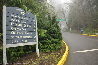
(Photo: J. Maus/BikePortland)
Get ready for yet another construction project that will impact biking routes.
Starting two weeks from now, on September 12th, the Portland Water Bureau will begin their Reservoir Improvements Project in Washington Park. The construction of a new 12.4 million gallon reservoir and other upgrades to two existing reservoirs will last for 12 to 18 months.
There will be significant impacts to nearby roads that will include complete closures — including bicycling traffic.
Advertisement
The most notable closure will be to SW Sherwood and SW Sacajawea roads — both of which are part of the main cycling route through Washington Park.
Here’s the key information:
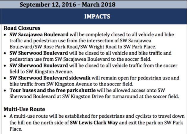
In the map below you’ll see where the roads will be completely closed and where the city plans to construct a temporary path to maintain through access connections for people walking and rolling:
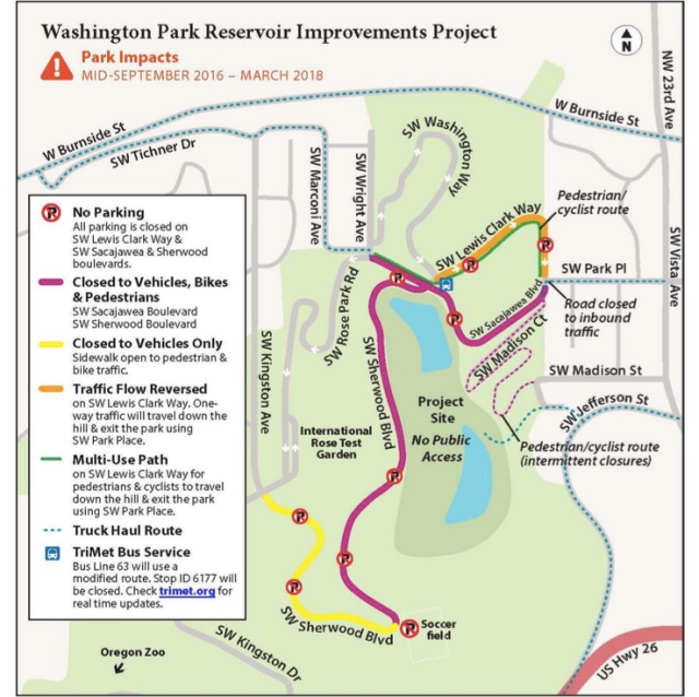
For more details and a larger version of the detour map, visit the official project website.
UPDATE, 12:36pm on 8/30: Just got more info from the city about how the project will impact the Madison Court Trail:
Beginning September 12, 2016 and lasting for 12 to 18 months (March 2018), the Madison Court trail will be closed intermittently for piping work. When the trail is temporarily closed, signage will be placed at the intersection of where SW Madison Street connects with the trail’s entrance and at the intersection of where SW Sacajawea Blvd. connects with the trail.
When the Madison Court trail is open, pedestrians and cyclists can enter the trail:
· From SW Jefferson St., to SW Murray Ln., to SW Madison Street, travel up the switchbacks, exit the trail on SW Sacajawea Blvd., and then travel up the hill into the park using the multi-use shared path on SW Lewis Clark Way, further connecting to SW Rose Park Rd., SW Wright Ave., SW Marconi Ave., etc.· Using the multi-use shared path beginning on SW Sacajawea Blvd, travel down the hill using SW Lewis Clark Way, connect onto SW Sacajawea Blvd., and enter the Madison Court trail
When the Madison Court trail is closed, pedestrians and cyclists can:
· From SW Jefferson St., to SW Murray Ln., to SW Madison Street, to SW Ardmore Ave., to SW Park Pl., and then travel up the hill into the park using the multi-use shared path on SW Lewis Clark Way, further connecting to SW Rose Park Rd., SW Wright Ave., SW Marconi Ave., etc.· Using the multi-use shared path beginning on SW Sacajawea Blvd, travel down the hill using SW Lewis Clark Way, connect to SW Park Pl, turn right onto SW Ardmore Ave., turn right on SW Madison St., to SW Murry Ln, to SW Jefferson St.
— Jonathan Maus, (503) 706-8804 – jonathan@bikeportland.org
BikePortland is supported by the community (that means you!). Please become a subscriber or make a donation today.

")


Thanks for reading.
BikePortland has served this community with independent community journalism since 2005. We rely on subscriptions from readers like you to survive. Your financial support is vital in keeping this valuable resource alive and well.
Please subscribe today to strengthen and expand our work.
Get ready for worse traffic. A Washington County Land Use & Transportation worker talked about the county wanting to work with Portland to wider Burnside and Barnes to 2 car lanes each way. So much for making it more livable. The Little Store on SW 90th plans to open later this year.
Sad face. That sounds like a disaster!
With a world class platinum seperated bike route, natch!
Traffic is not a problem in Washington Park. How is it going to get worse?
Adding another eastbound lane to Burnside would do absolutely nothing to improve traffic. The bottleneck is the first set of lights as you hit Portland near NW 23rd. Adding another lane won’t improve throughput, it will just provide more space to store cars stuck in traffic.
What they should do, however, is remove the second westbound lane and add bike lanes. There are no signals on the uphill section, and no need for a “passing” lane.
Okay, so coming down it’s just turn left onto Lewis & Clark instead of straight ahead onto Sacajawea.
Coming up off Park or Madison Trail is walk the bike on the MUP?
So if I’m coming down Kingston from the zoo where do I go at the Rose Park/Sherwood intersection? Do I make a hard left to stay on Kingston then go through Marconi and Wright to the MUP?
Well, that’s helpful. Not. I sent them a note suggesting they describe complete, contiguous, signed routes through the park, rather than the partial bits of information. This has broken a highly-used route, and they need to plan for that.
The Water Bureau is used to doing exactly what they want, and not what they should do, particularly when it comes to road closures and detours.
Will the Madison Court switchbacks remain open? It’s kind of hard to tell on the map. A couple weeks ago they erected fencing that looked to me like Madison Court would remain accessible. I guess I can handle losing Sherwood and Sacjawea Way for construction as long as other reasonable measures are taken to minimize the impact on commuting and recreation.
the madison path will have intermittent closures
Wow, what a monster project, and I like the detour plan, it’s so intricate!
I left a request to add a sign to 20th and Jefferson so westbound bikes and peds always know if the Madison Court trail is open or not….because it’s quite a detour to get all the way up to the trail then come back and go around to 20th, then Salmon, then park and back through the park.
(Thanks to PWB and PPR for continuing to allow bikes and peds to use this trail.)
So that map pretty much only shows roads that motorists can use, the City has already repaved sections of SW Sterns Rd., which goes from SW Washington to W Burnside and is closed to motor vehicles, as part of a detour for cyclists and pedestrians while this construction project is active, but that doesn’t even show up on their map.
That map is utterly confusing.
It would have made a lot more sense to design a map showing what is OPEN to bikes. I cannot make head or tail of how I am supposed to get anywhere looking at that.
FYI just posted:
UPDATE, 12:36pm on 8/30: Just got more info from the city about how the project will impact the Madison Court Trail:
Should be interesting. Finally something to force me to mix-it-up when it comes to my daily commute!
Can I now ride Wildwood?
I heard back from asking the Water Bureau to describe complete contiguous routes through the park. They are on it now. We’ll see what they come up with.
(Riding UP SW Park just really, really doesn’t call)