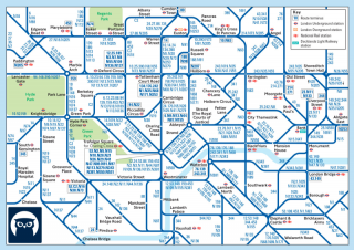
(Image via Cameron Booth)
This week’s Monday Roundup is brought to you by Lancaster Engineering, a Portland-based firm that is hosting a “Parking Pow-Wow” event tomorrow (2/23).
Here are the bike-related links from around the world that caught our eyes this week:
Terrible maps: The world’s worst transit maps are pretty funny.
Bike migration: 7,000 abandoned bicycles near the Mexican border put journalist Kimball Taylor on the trail of a man who made millions smuggling humans northward.
One-way streets: Less human-friendly than two-way streets, right? Not so fast, argues the blog Urban Residue. Part of its evidence: Portland.
Hmmmm…: Ford is spending millions to brainstorm some sort of device or system that can get three people carrying shopping bags eight miles through a dense city in 45 minutes for less than $10.
Missouri madness: The same state representative who wants to require every bicycle to carry a 15-foot-high flag also wants to legalize ATVs on a major rail-trail.
“Bike superhighway”: Texas is building a 64-mile path from Fort Worth to Dallas.
Biking miners: They were a big part of the 1898 Alaska Gold Rush, in part because you “never had to go outside at 40 below to feed a bicycle.” Some even made the trek in toeclips.
Bus alarms: Clark County’s C-Tran is testing camera-activated alarms to warn of possible collisions.
Construction zone fatality: Wherever the fault lay, it seems likely that better standards for construction zone design might have saved Margaret Rugg’s life.
Disruptive activism: The rapid rise of the new Sustainable Trails Coalition has prompted the long-established International Mountain Bicycling Association to take a “more aggressive” tack.
Advertisement
Illegitimate opinion: An NYC neighborhood association official says two people who voted to approve a protected bike lane should have abstained because their support for a pro-biking group constitutes a conflict of interest. (Another biking advocate thinks this is a great idea.)
Tailpipe casualties: 5.5 million people per year die from air pollution.
Perverse process: Santa Barbara residents claim that California’s environmental protection law forbids removing auto parking to add bike lanes.
“Missing middle”: Commissioner Steve Novick is the latest Portlander to call for re-legalizing mid-size housing such as four-plexes and garden apartments.
NASCAR bikers: A squad of race-car drivers biked 60 miles to the Daytona Speedway to raise awareness of road safety.
Risk factors: People are far more likely to be distracted by their phones while driving than while walking across the street.
If you come across a noteworthy story, send it in via email, Tweet @bikeportland, or whatever else and we’ll consider adding it to next Monday’s roundup.
— Michael Andersen, (503) 333-7824 – michael@bikeportland.org
BikePortland can’t survive without paid subscribers. Please sign up today.


Thanks for reading.
BikePortland has served this community with independent community journalism since 2005. We rely on subscriptions from readers like you to survive. Your financial support is vital in keeping this valuable resource alive and well.
Please subscribe today to strengthen and expand our work.
I have good memories of the bus system in Debrecen, Hungary. Easy and frequent, but I wasn’t relying on a map.
Re; this story:
http://www.bikingbis.com/2016/02/16/proposed-laws-affecting-missouri-bicyclists-defy-logic/
Relative to use of natural lands for recreation, there are significant parallels between biking and ATV’ing. First and foremost, is that both are vehicular recreation.
It should be noted that in Missouri, the bill for a law being proposed, “…would allow ATVs (all terrain vehicles) and golf carts to be used by disabled people or those over 55 on the Katy Trail on the first and third Wednesdays of the month. …”. In other words, not for just anyone that wants to ride an ATV on the trail, as this Roundup’s summary line might suggest to some readers.
From the story, it also should be noted that the path in question, is a 238 mile gravel paved trail, rather than dirt, from which it’s been estimated that associated tourism income amounts to 18 million a year.
In simple terms, the bill the Missouri rep proposes, is to provide basic accessibility to the trail by people that are disabled, or that are 55 and over. The bill should specify and limit for basic accessibility, precluding some of the fast, energetic types of riding that are commonly associated with ATV use…although many people that ride ATV’s, don’t ride them at more than slow speeds.
Could what the Missouri bill proposes, be a reasonable fit for that state’s premier rail to trail ride? I haven’t yet read the bill proposal (link is in the story.). Depends on the details. There’s lots to think about.
One thing for example, is that definition of ‘disability’ relative to the ability to do certain activities, sometimes can be vague. Such a law as Missouri may consider, should make efforts to be certain that nobody can use an ATV on that trail unless they truly can not ride a bike. Specific top speed limitation for ATV travel on the trail, should be included also.
Use of ATV’s on this type of trail is naturally a provocative idea, but it’s a good point that legitiamately disabled people ought to have some accessibility that would allow them to enjoy the natural experience such trails offer.
Disability aside, the 55+ segment opens up the trail to a whole lot of potential users, for better or worse. I wonder if the 55+ designation applies only to driver? If so, then I can see whole convoys of senior-driven ATVs & golf carts with all manner of passengers – spouses, adults and grand kids, friends, dogs, nannies… Some so-called ATVs are pretty large. That’s a lot of weight to put on a gravel trail.
Especially with the typical weight of your average person in Missouri. As to “disabilities”, you will find that a significant portion of the population is “disabled” due to obesity. We shouldn’t be surprised that they want to open up one of the few non-motorized pathways to motorized use.
***comment deleted because you made a direct and mean personal insult***
“unthinking buffoon”…. Hardly a horrible reply to a ludicrous statement. Would BP.org edit this phrase if used against Amanda Fritz ? I think not. Slandering an entire state, based on theoretical prejudice is OK, but pushing back is not. Shame on you. I challenge you to a duel, sir ! Haha!
Chris… I hold my turf. Portland metro 26.8% obesity rate to KCMO’s 28.4%. Slide a razor between the two.
America is fat everywhere.
Your sophomoric claim false of superiority based on a contrived sense of class or place is off putting .
Did you read the bill’s text? Link is in the article. It’s being worked on, so conditions and stipulalations could be introduced. One thing it already says, is that max speed for atv’s is 15. I’d suggest lower. Also, perhaps only one additional ride nt necessarily disabled or 55 and over. That’s just a few of the ideas about this subject that occur to me. Let’s hear more from other people about this.
And the ATV can do 50 mph. How well are the speed limits working on regular streets with no enforcement?
Here’s the direct link to the Transit Maps Hall of Shame. He’s local to the Portland area and runs a great transit maps blog, not just showcasing the bad ones. He also has a store where you can buy printed maps for displaying on your wall. I highly recommend!
Here’s the book on the “migration bicycles” thing:
http://www.powells.com/book/the-coyotes-bicycle-9781941040201/18-0
http://www.amazon.com/dp/1941040209
Sounds interesting, but I will probably wait for it to drop in price.
Re: Ford Article. Um… a bike? What a complete waste of resources. The team in the article seemed to spend months confirming what we all already know and creating something that just further complicates people lives when it comes to transportation. A group of people will earn actual US currency for that “work”… what a world.
Hey Ford, I’ve got an idea: Jet packs! Email me for my bank routing number.
Seriously, though, in this case the end result seemed quite underwhelming. The overall approach to generating ideas to solve problems is pretty cool–I’d certainly take that job–and an interesting read, but all that effort to generate a few ideas for apps that already exist was quite the dull ending to that particular story.
Bikes are a big part of the solution (the old problem of everything looking like a nail if all you’ve got is a hammer) but they don’t solve the whole puzzle. If all you do to get around is ride a bike, then I suppose the problem may not be obvious.
Personally, I’m finding myself very much a multimodal commuter since our move, which means that I don’t *just* bike. I use the transit system, bike sharing, occasional point-to-point carsharing and infrequent return-to-origin carsharing.
One of the problems I think Ford is trying to solve here is that these systems don’t even begin to work together.
Payment and access are completely separate, for one thing: I carry separate cards and/or keyfobs for Metro Transit (and TriMet!), Nice Ride bikeshare, car2go and Zipcar, and I get separate billing and debit-card charges for each. Fortunately Hourcar (a local Zipcar-like service) lets me use my Metro Transit card to open their cars, the kind of sharing I’d like to see more of, though payment is still separate. I would love to have a single fob or card that gets me onto buses, trains, share bikes and short-term rental cars, and get a single bill at the end.
Trip planning is completely separate, too. Again, I have separate apps on my phone for Metro Transit (and TriMet!), Nice Ride, Car2go, Zipcar and Hourcar. So if I want to plan a multimodal trip I have to hop between apps to figure it out: maybe check the bus schedule first since that’s fixed, then isn’t there a sharebike station at … oh wait, there isn’t; it’s a mile from there … ok, I’ll take a different bus route to a sharebike station … ride that for a couple miles to my first destination … then after that errand is done I need to go a mile and a half to somewhere that isn’t well served by either bikeshare or transit … OK, fire up the Car2go app … oh, there aren’t any cars near the sharebike station I had in mind, but there’s one about a mile away … back to the bikeshare app … ah, there’s one that’s near the car2go that’ll work … great! now back to the car2go app to reserve the car.
This is how multimodal commuting works today. Technology has enabled things we couldn’t have imagined a few years ago, but it’s still patchwork when you try to use multiple systems.
As we’ve discussed before on this site, figuring out how to bike from A to B often takes advance planning and multiple maps in itself. Combining it with transit or other modes increases the complexity further. Google Maps is mostly decent for bike routing, and pretty good pretty good for trip-specific transit routing, but it can’t do both: I can plan a transit-based trip that also includes up to a mile of walking, but I can’t use it to plan a trip that combines transit with bicycling, let alone bike sharing.
Thanks for the one-way/two-way streets article. Strong Towns likes to occasionally bring up the evil of one-way streets and it never made sense to me. I get around mostly by walking and I find one-way streets feel MUCH easier and safer to cross. If there are no signals or stop signs to stop traffic, finding an opening in two-way traffic on busy roads that allow me to cross is very difficult.
Portland is a great example of why pigeon-holing one-way streets as “bad” is silly; as in all things, it is the context in which your one-way/two-way streets are operating. E.g. don’t like fast one-ways? Coordinate the traffic signals so that you get a ‘green wave’ at a lower speed.
I had a Masters student investigate ways to analyse the pros/cons of one-way vs two-way street projects; see http://hdl.handle.net/10092/10144 for a paper on her findings. It was interesting to see the bias inherent in much of the literature she reviewed. She also interviewed a number of different transport professionals (engineers, planners, etc) and again there were initial differences in how different people perceived the relative merits of each.
Agreed, I’m not convinced one-way streets are always bad. Yes, they’re bad when they’re 3 or 4 lanes blasting through a moderate density neighborhood, but my gut tells me they can be a good thing in a dense urban environment.
I just recently became aware of the “one-way=bad” position during a recent discussion on streets.mn about a Burnside-like street (Hennepin Ave) in Minneapolis, which got converted from one-way to two-way a couple years ago. I questioned why it had been changed, and learned that it was almost an article of faith among a lot of people that one way streets are inherently more dangerous for pedestrians.
My thinking is that they are bad only to the degree that they increase vehicle speeds. Vehicle speeds being equal, I suspect one-ways are actually safer for bicyclists and pedestrians. The trick is to design them in such a way that vehicle speeds don’t increase: both physical traffic-calming measures and signal timing can help with this.
And the thing about “green wave” signal timing to limit vehicle speeds is that it can ONLY be applied effectively on one-ways. On two-way streets it’s not in your toolbox, and you have to resort to other means to keep speeds down.
I think you are on the right track here. In Hillsboro, we’ve been debating eliminating the downtown one-way grid in favor of two way traffic. Of course, the real problem streets (Hwy 8) that run a few blocks south of downtown would remain one-way. That couplet is fast cars and few safe crossings. The rest of downtown’s one-way streets are calm and easy to cross at any time of day. It looks like one-way will win out and I am happy to see it.
https://www.portlandoregon.gov/transportation/article/328907
I do wish they would post the green wave speed — so tiresome to have drivers speed around you and stop at a red. over. and. over.
Re: miners, are we collecting biking stories that change a life? An ex’s dad in Ireland didn’t get married til he was 30, cuz that’s when he was able to get a bike and could ‘go courting’. The ex was one of 5 kids so I’d say the bike courting was pretty successful. ;o)
That Ft. Worth to Dallas trail sounds impressive, a 64 mile system put together in 4 years?
I’m a little blown away by how huge their metro area is. I guess thats what happens when you don’t have many natural barriers to development.
That story is old, decades old. This thing has been on and off the radar since I bought a house in Garland back in the ’90s. Originally it was part of a network of off-road paved bike paths called the Veloweb.
Ft Worth and Dallas were two different cities which happened to be located close to each other. But faster transportation and population growth caused the region to grow into one metropolitan area during the mid to late 20th century. Same story with San Francisco + San Jose, or Tacoma + Seattle.
Sure, different cities, that doesn’t mean much though. Pretty much all cities are agglomerations- Portland’s downtown grid is weird because it’s three “cities”, the east side of the city used to be independent towns.
Here’s a population density map of DFW: http://cberan.cartgis.unomaha.edu/3530/multi/map8.htm
Unfortunately sprawly cities are common in the US- Houston and Atlanta come to mind, and Kansas City is probably the worst. I’ve always assumed Google Fiber started in KC because it’s actually easier to lay infrastructure with that lack of density. Sure, you have to dig farther, but you don’t have different eras of utilities to worry about.
If you check out the story, you’ll see major portions of the 64 mile route are existing trails in the respective cities. The new project is some, but not all, of the connections between those segments to make it into a contiguous route.
Nice piece on the DFW Bikeway from the folks at KERA in Dallas. Hope that comes to pass, because that area has freeways and tollways running throughout that area…too many, perhaps. Texas is taking baby steps in the direction of a statewide bike policy. There’s a trail much like this that already exists in Minneapolis / St. Paul linking the Twin Cities across the mighty Miss that other areas are looking to for inspiration. Perhaps we should as well!
RE: Construction zone fatality…the more I dig into avoiding this type of outcome locally…the more I am finding systemic failures at all levels and with all parties planning and maintaining these work zones…as they relate to ADA ped and bicycle access and safety.
Plus too many TCPs are set up and miss the [silver lining] opportunity to use the ped/ bike deviation pathway (not detour) as a buffer to protect their workers from motorized traffic…an outcome included in the MUTDC guidance.
In a recent example, in discussing multiple transit related work zones, it snowballed into each side thinking the other agent was responsible for the task and it had instead been undone until the complaints started coming in.
This recent collective example is reaching deeper into areas I had not considered such as the original requirements of the contract setting up the work zone etc.
Sorry typo…MUTCD
I like the signs “slow | children texting”. Have to wonder sometimes whether “constitute an immediate hazard” takes into account the fact that the driver is speeding (there’s also the definition of “recklessly” or “reasonable person”.) http://www.oregonlaws.org/ors/814.040 — as in, at what distance is a driver not required to stop in e.g. a 25mph zone with a clearly marked crosswalk and clear sightlines?
If anyone feels inclined to test this, please do so safely with the non-meat parts of: “including but not limited to any part of the pedestrians body, wheelchair, cane, crutch or bicycle”, bowl of petunias, etc.
+1 for the Hitchhiker’s Guide reference.
Love the urban residue article. And I always appreciate any article which argues against the all too often quoted yet unproven “common sense” arguments that plague transportation and planning issues. Be it bicycle helmets, one-way streets, adding lanes for congestion, or that travel speed equates to faster travel time on urban streets (which this article also addresses).
And it coincides quite nicely some thoughts I’ve recently had on expanding the one-way system to some of the commercial districts for adding bike lanes ( a Hawthorne/Belmont loop from 20th to 49th and a loop for NW 21st/23 in particular).
Basically 2 one-way lanes for cars, one lane for dedicated rapid bus, and in the case of Hawthorne 2 auto sized lanes for bicycles(one auto sized lane for the other streets), all of which could be done mostly with just paint. All existing auto parking could be preserved though I’d want more controlled intersections for controlling speed as well – which these streets need more of right now anyway.
Sounds like you’d be forcing a lot of traffic through the residential streets in between, many of which are already effectively single lane because of on-street parking.
Natural traffic calming at it’s finest. It’s hard to speed through a neighborhood directly at oncoming traffic.
Regarding the Santa Barbara bike lane/parking removal lawsuit: The California Environmental Quality Act (CEQA) had previously required that all road projects protect “level of service” for cars. I understood that it is being/was changed this year to remove the level of service requirement after a fight over a transit expansion in San Francisco showed how absurd it is.
I was not aware that it had any provisions protecting on-street parking. I doubt if it does. Where are the environmental grounds for prioritizing on-street parking over active transportation? This would be funny if the stakes weren’t so high.
Missouri insanity:
If you bike across the country, you might want to contact a representative to oppose this bill. There is an action to do just this.
The site would have you insert your zip code to look up your representative, so I used my friends address zip in KC: 64108.
http://mobikefed.org/2016/02/advocacy-alert-bill-allow-atvs-katy-trail-moving-forward-missouri-house-contact-your-represe
I don’t think “Parking Pow-Wow” was an appropriate name for your wonk night. Cultural appropriation is not cool, even when bikes are involved. 🙁
Hi Erinne,
Thanks for telling me this. I had not thought of it that way. Also, just to clarify, that event has nothing to do with Wonk Night.
I just noticed that distinction, thanks for clarifying. Hopefully I shame them enough that they don’t choose that language again. You can’t be picky about your sponsors and what they want to promote.
E, you took the words right out of my mouth (and 30 minutes ahead of me…) Folks, your meeting, brainstorm, idea exchange – is not a pow-wow.
It has been for many decades. At least until social censorship manages to whitewash our language completely.
Wait, is whitewash co-opting someone’s culture?
A pow-wow is a social gathering and in the North West we’ve taken in many words from resident cultures into our vernacular. Unless you expect us to purge all ‘foreign’ words from the mish-mash that is the English language, powwow when used in a nonoffensive context is perfectly fine.
Else we will need to start calling Chinook ‘King Salmon’ and that’s not okay.