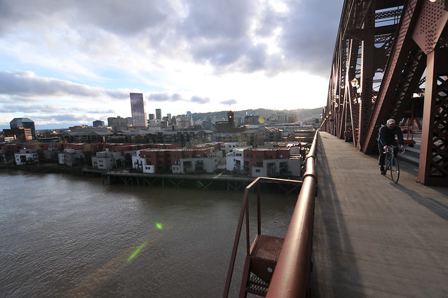
(Photo: J.Maus/BikePortland)
As redevelopment proposals for Northwest Portland’s big post office have moved forward, some insiders have been talking about an exciting concept for the site: a flyover ramp that could directly connect the bridge’s 30-foot-high Y-shaped west landing with a new north-south bikeway through the Park Blocks.
Envisioned as a key link in a proposed Green Loop biking path around the central city, a well-designed route through what’s supposed to become a major mixed-use employment and residential development would certainly be costly if it took the form of a floating path — but would also seem likely to become one of Portland’s most iconic pieces of bike infrastructure, reminiscent of Copenhagen’s new Bicycle Snake.

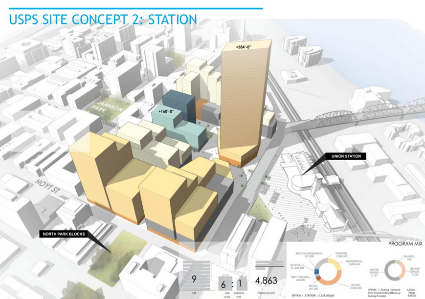
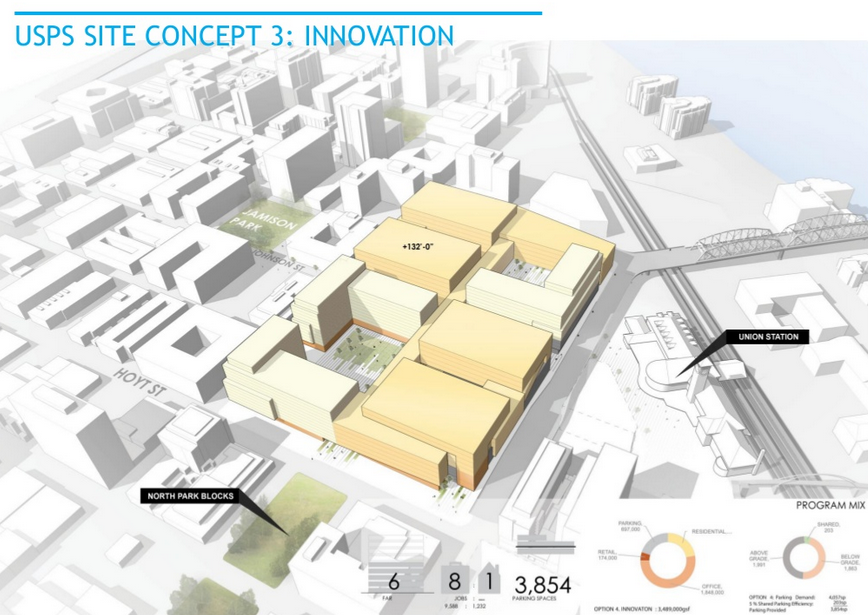
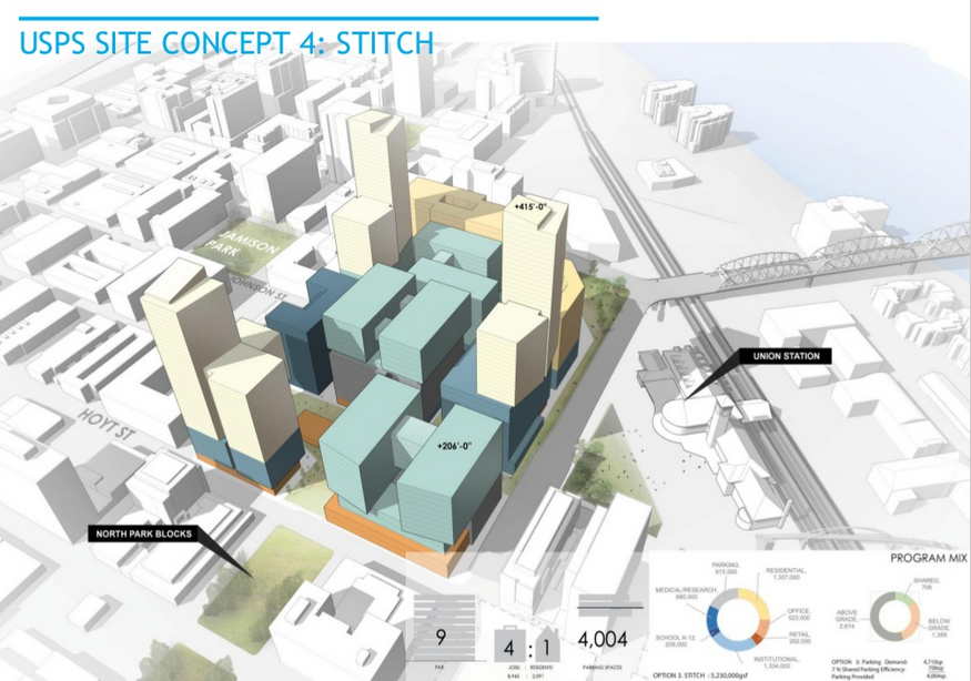
(Image: PDC)
So when the Portland Development Commission last month released five renderings with various possibilities for the Post Office site, it was a minor surprise that none of them explicitly included the possibility.
Here are the five concepts released by the PDC, which is the city government’s in-house economic development agency:
First, the “Cascade” concept, which PDC staff said probably includes the recommendation most similar to a flyover path because it specifies a “central path” for the Green Loop. The design pictured, however, uses a series of weaving staircases to reach ground level north of Hoyt Street.

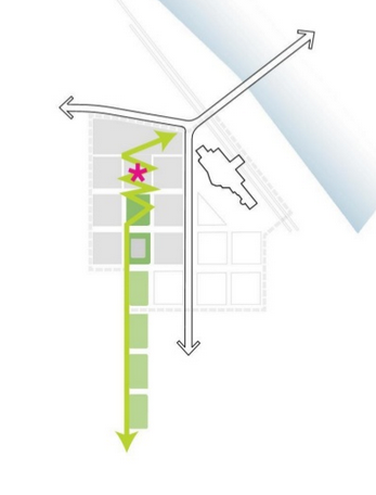
Here’s the PDC’s “Station” concept, which focuses on creating a new public plaza area in front of Union Station and would jog a central bike route west on Johnson before turning south onto an extended Park Avenue.
Here’s their “Innovation” concept, which PDC staffer Sarah Harpole said is focused on creating a site that could be home to “the Amazon, the Googles of the world.” It imagines a more cohesive, lower-rise set of buildings with a bike route running beneath them on Park Avenue.
Here’s the “Stitch” concept, which sets out to create a continuous, retail-activated 6th Avenue around Union Station that would create a sense of continuity between the Pearl and Old Town in front of Union Station. Unlike the other concepts, this doesn’t envision any descent of bikes from the Y of the bridge, but would instead send bikes west to 9th on the existing Lovejoy viaduct before giving them a chance to turn south.
Finally, there’s the “weave” concept, which creates a more meandering route (and, presumably, the gentlest possible slope) through the site:

Advertisement
Though there’s something to be said for all these possibilities, I wanted to know whether that iconic flyover concept was out of the picture.
“We’re kind of at a very early level in our diagrams,” Harpole said. She says these plans shouldn’t be considered as distinct alternatives, but rather collections of concepts that could be mixed, matched and edited. The PDC wants to hear, for example, how worried people are about weaving and how worried they are about the slope, and which sorts of grid connections people would find most useful.
“It was just meant to be provocative, part of a conversation,” she said. “As we start to take these five concepts and boil them down into more refined, into a single concept, we’re able to take that feedback.”
As for the pathway, Harpole referred me to Nolan Lienhart of Zimmer Gunsul Frasca, the Portland-based architecture firm that’s managing the site design and planning process.
“I don’t think it’s out of the picture yet; I wouldn’t even say that anyone has even started trying to push it out of the picture,” said Lienhart, who is enthusiastic about the concept of a “floating, flying pathway.” “There’s a number of different ways it could happen.”
Green Loop bike route, associated
with the “Cascade” concept.
The key constraints, Lienhart said, are the cost and the slope of the path, which would need to be 600 feet long or more in order to achieve the 5 percent slope required by the Americans with Disabilities Act.
“Typically conservative engineers will have you design at 4.75 to be safe,” Lienhart said.
The distance from the center of the Broadway Bridge’s “Y” to Hoyt Street is about 900 feet, so there’s not much space to spare, but Lienhart thinks it’s possible if the full length of the site were to be used.
In any case, Harpole said, the various possibilities for getting people from the Broadway Bridge to the Park Blocks on bikes should be seen as a route that would add to the options for people biking rather than replacing the existing (though definitely imperfect) descent on Broadway toward the heart of downtown.
“I think you always assume Broadway is an active bike corridor,” she said.
Harpole urged people interested in the proposals to submit feedback to the PDC using its online Town Hall.
“We’re at the design idea phase, so what we want to do is just hear from folks,” she said. “The more perspectives we get, the better.”


Thanks for reading.
BikePortland has served this community with independent community journalism since 2005. We rely on subscriptions from readers like you to survive. Your financial support is vital in keeping this valuable resource alive and well.
Please subscribe today to strengthen and expand our work.
PDC wants to hear, for example, how worried people are about weaving and how worried they are about the slope, and which sorts of grid connections people would find most useful.
Beautiful words! And, as the immortal poster of Fox Mulder says, “I Want To Believe.”
I want to believe in the flying bridge!
I would start by eliminating the proposed 3,000 car parking spaces. The area already has great access to MAX and Streetcar. No need to induce more car trips.
I’d like to see the park blocks extended and a safe decent from the Broadway Bridge into the park blocks; separated from car traffic. It would certainly be heavily used considering how busy the Broadway Bridge is with bike traffic.
I do like the plaza and retail in front of Union Station. That area isn’t the nicest, and some more “eyes on the street” and foot traffic could certainly help with that.
I thought the ADA 5% grade was just for pedestrian access, not for a bike path…
or were they still using old-century design and thinking of creating a MUP?
they could easily create stairs and an outdoor elevator for pedestrians and give bikes a steeper slope… there are already plenty of steeper bridge approaches in the area for bikes…
If they’re going for the 8-80 thing (which I see no actual evidence of, but still…) then I’d argue for the less-steep path. For many of us, a steep climb is kind of a dealbreaker.
Yes, and no doubt there will be other modes developed (better segways, better skateboards, innovative transport contraptions for kids that we haven’t thought of yet) which will be sharing the path in future, so yeah, have to be ready for that by not building designed in roadblocks.
Heh. Yeah. I clicked on the link to the “snake” images and didn’t see a one with pedestrians using it. From now on, I don’t think I can hear the term “Bike Infrastructure”, when what we really mean is “MUP”. That’s maybe “Non-motorized infrastructure”, but let’s not call the creation of a MUP a “bike” project: A) it’s not, and B) it makes people think that all the expense is for “those non-tax-paying cyclists”.
I’d only like that if a developer paid for it. There are other pedestrian and bike bridges in Portland that need to be built before that one.
I meant; paths and such.
I appreciate the creative brainstorming, but flying over may not be the best approach to crossing the intersection and connecting to the N. Park Blocks. Why? Because, at a minimum the structure will need to be at least 20-25′ above the Broadway-Lovejoy intersection, which adds to the already challenging hill climb route to the North Park Blocks (see the option illustrated with a switchback sketch). How about going under? This may be more practical and more bicycle-friendly: Less elevation to climb; opportunities for other connections to Union Station, Naito, etc. Just a thought…
Wouldn’t going under require a retrofit to the Broadway Bridge?
so would going over…
Pretty soon bike ridership will be lower in the inner portland areas. Since people who ride bikes will have to live else ware because of rents. There would be no point in building this.
No, all the cool “Creative Class” people who are supposedly going to flock to these high rent areas will have bikes. The bikes may be stored in the code-access garages alongside their practically self-piloting SUV entertainment and communication centers-on-wheels, but they will ride them once in a while.
And, snark aside, many of us ordinary folk who live in lower rent areas of North and Northeast still work and/or recreate in the Pearl, Downtown, and Northwest, and the improved bike access through this project would make a huge difference.
As of now, I almost never go into Northwest because it’s just so crappy getting there from NE.
The Pearl has done more positive things for affordability than any other neighborhood in Portland. Firstly, there are thousands of affordable (subsidized) housing units in the neighborhood, a fact that people rarely seem to know, perhaps because those buildings blend in so successfully. Secondly, the creation of thousands of units of market rate housing units (some rentals, some condos) has reduced upwards pressure in older buildings in nearby areas such as Northwest and Goose Hollow. The redevelopment of the post office site is an opportunity to continue this legacy.
It’s true that poorer people commute by bike a bit more than rich people, but not a lot more. However, this is offset by the fact that rich people take more recreational bike trips (which is, in turn, mostly because rich people take a lot more recreational trips by every mode – a big part of being poor in the USA is that you just don’t go very many places, even in your hometown). So the richification of central Portland might put downward pressure on bike commuting numbers but it’ll probably have little impact on overall bike use.
The main effect of filling the central city with rich people is that the poorer bike commuters either choose not to bike because of the distance or have to bike much longer than they would like to. Both of those things are bad, of course.
Because… people who can afford higher rents are attracted to the inner city because they don’t like bikes?
Ooops… that was a reply to WAR
If 2k for a studio is considered affordable by a person. That person might also be able to afford a better form of transportation. Why get all sweaty when your “self-piloting SUV entertainment and communication centers-on-wheels” is easier to drive. There making payments on it. Might as well drive it.
Unless you buy that whole “corporations are people” nonsense, I don’t think many people will own self-driving cars.
Think of transportation as a service, where you’re riding in a robot-operated Uber. It eliminates the costs of driving: time, insurance, maintenance, financing, etc. It pools resources, not just by sharing rides but by keeping vehicles busy more than an hour most days.
Fewer vehicles on the road, lower (if any) fixed costs, free valet parking EVERYWHERE, not a bad deal.
Yes. We’re huge into class warfare here.
A flyover would be amazing! But I’m not going to hold my breath.
A definite big, fat “no” to any subterranean bike paths. One of two things will happen there: either it’s a big vector for violent crime late at night, or it gets closed at night – neither is desirable or useful.
While some people might be okay with a zig-zaggy path, I would continue to use Lovejoy or Hoytt if that’s what they opted for. The switchbacks cause problems where opposing direction traffic happens and gets worse when intermixed with pedestrians. It’s also rarely friendly to bikes with trailers.
It would also become instant refuge for lots of homeless and double as a pissoir.
More 24-hour public restrooms!
I keep hoping for a protected bike lane across the Fremont bridge. That’d be perfect for my needs, beings as how I work in the shadow of Montgomery Park and I live near Fremont and 33rd! 🙂
I often fantasize about a marsupial bridge under the Fremont. For now, enjoy this marsupial bridge from Milwaukee, Wisconsin.
http://farm1.static.flickr.com/156/425900643_d574c8dd6b.jpg
Just saw one of these in Missoula. I really wish Portland could put these on all our bridges, if feasible.
“As of now, I almost never go into Northwest because it’s just so crappy getting there from NE.”
Likewise
This is why any transportation project that increases human mobility should be top of the list for funding… alas.
Such a deal! Millions of dollars spent to get approximately 2-3 blocks of traffic free riding in The Pearl. Meanwhile, in the old and unfashionable parts of town, bike users will continue to navigate an increasingly busy grid of high speed roads while the city continues to study and vainly search for the resources to pay for the sharrows, striped bike lanes, traffic calming devices, bike boulevards, etc. that we know work for the majority of riders.
But elevated bike paths look soooooooo rad in tourism brochures and P.R. releases!
Do you think riders in the Pearl don’t have to navigate an increasingly busy grid of high speed roads?
Of course they do but, why spend millions on a fancy flyover when a street like NW 13th Ave. could be turned into a ped/bike mall featuring minimal auto crossings with some concrete/steel bollards and bike signals? We should be looking into less costly solutions that improve safety and neighborhood livability. As Anne Hawley states above, the “sexy” high cost / minimal benefit solution appeals to all of the parties involved for obvious reasons. Follow the money and the bureaucratic prestige!
It’s not a zero sum game. If a developer thinks the market would reward badass bike photo ops in their project, we should embrace that.
This whole area will require millions of dollars in public investment to be ready for redevelopment. The PDC is planning to build new streets (at least for pedestrian access) and utilities already, and the private developers will spend 100’s of millions of dollars on new structures. Since the public is making this huge investment anyway, we need to speak up now, so that the new paths work for bikes as well as pedestrians. The money will be spent either way; it might as well provide world-class bike infrastructure.
Whichever option costs the least and generates the most jobs and income fro the city. Please stop spending my money on nonsense
I’d say that underneath all the fancy design and survey language is some attempt to arrive at a definition of nonsense that everyone involved (financially) is willing to live with.
Glad to see Bikeportland.org putting the flyover path in the discussion
I wish more of these designs extended the North Park blocks farther north. Only the STITCH and the CASCADE include limited and disconnected extension of the park blocks. In my opinion, having more intimate, proximal, and human-scale or pedestrian connections to public green space surrounded by a denser urban form is really what makes Portland Portland. The lack of connected openspace in these designs make many of them look more lake Seattle than Portland.
Okay… I guess I missed the WEAVE which is certainly the best in terms of providing human-scale interstitial green civic space. But not connected with the North Park Blocks.
A flyover sounds cool and I’m sure it would look cool, but let’s see the price tag. If a 600 foot long elevated skyway is a multi million dollar project, that’s not good value for money.
I’d rather have a new bridge over I-84 south of Lloyd.
I’ll believe it when it happens, which I expect to be never. This talk now is simply a distraction, to let the plans get far enough along without people in the bicycling community vocally protesting why the flyover isn’t explicitly stated as a design goal. If it was that important, it would have at least been mentioned somewhere in one of the designs.
Oh how exciting! More downtown bike infrastructure!
It seems that the windy ramps will be a deterrent for anyone coming from NE, especially for the huge chunk of people with destinations east of the Park Blocks. I say this not just because switchback ramps are annoying, but they also take more time to traverse. Will people who are currently riding on Broadway actually switch to biking along the Park Blocks? And don’t forget that the Park Blocks are currently full of stop signs and awkward crossings. Making the entire Park Blocks corridor, from the Broadway Bridge all the way to PSU, would require a major, costly overhaul. I see lots of “compromises” being made; where green wave signals are (hypothetically) promised, many of the stop signs could remain due to NIMBY bikelash.
This whole proposal seems to detract from the real issue: Broadway is ideally situated and has so much potential to become an 8-80 bikeway (or close to it) if the City acts boldly.
EDIT: *Making the entire Park Blocks corridor bike-friendly
Maybe I’m missing something. What would be wrong with the “Cascade” concept? I’m assuming there would be a separate signal cycle at the west end of the Broadway bridge that would allow cyclists to access the new ramps. Combine this with improvements along the park blocks, and we would have an excellent north/south bike route through downtown.
I’ve ridden on this path in Gothenburg, Sweden. Seems like a good concept:
If the path connects to the bridge in the Y, does that mean everyone would have to wait to cross the motor lanes at crosswalks?
If so, I’d prefer a design that instead connects directly to the sidewalks, either going under the Lovejoy and Broadway ramps and then up to the bridge sidewalks… or connecting at the base of the existing ramps, as the street grid does now. I want to merge onto the bridge sidewalks smoothly, not complicate the intersection at the west end of the bridge with new crossings.
Rather than a flyover TO the Broadway Bridge, let’s think about a whole new bike/ped BRIDGE across the Willamette just north of the Broadway Bridge. Something iconic, sweeping, beautiful.
It could land on the east side just north of the existing bridge where a bit of open space is joined by way too much asphalt. On the west side it could sweep over the RR tracks north of Albert Mill, then down to 9th avenue or to an extension of the North Park Blocks in the new USPS project area.
How about a new bridge just north of the Steel for MAX and bike/ped? The steel is a major bottleneck for the whole system.
Whatever is eventually done, I am sure BP commenters are going to hate it.
A bike/ped flyover path like this would be incredible! The “Bicycle Snake” was by FAR the coolest piece of infrastructure on which I biked in Copenhagen; nothing else even remotely compared. To have something like this connecting deep into the Pearl District from the Broadway Bridge would be absolutely epic!
We could have had the old Sauvie Island bridge used as a gorgeous NW Flanders I-405 crossing for only $1.8 million, but political fear prevented that from becoming a reality. And hopefully we’ll still have the Centennial Mills to Fields Park flyover (even if Centennial Mills is *tragically* destroyed!).
But a Portland version of Copenhagen’s Bicycle Snake (placed in a way, way more important location than Copenhagen’s version) could be even more amazing than Tilikum Crossing! But that will be true ONLY if this flyover is seamlessly integrated with a dedicated, 100% car-free pathway through the Post Office property, as envisioned with the Green Loop.
Most of our “cycling” infrastructure still varies between pathetic and nonexistent compared to any city in Holland (and many cities in Denmark, Sweden, *Minnesota*, Germany and scores of other places), but a bridge-to-park-blocks-integrated-with-Green-Loop path that forms a totally car-free loop around downtown on both sides of the river would be a dream come true!!
Hopefully THIS dream actually WILL come true. And maybe it would even give us momentum to make progress (for once) on the urgently needed Sullivan’s Gulch corridor. We’ve been let down far too many times, despite the incredible efforts of the wonderful people who write for and follow BikePortland!! One truly showcase project like this might actually (finally) wake up City Council and get them excited about supporting things other than moving cars, parked cars and building multi-billion-dollar monuments to cars!!