(Image: Portland Bureau of Planning and Sustainability)
City planners and stakeholders are looking closely at an unsolved problem of Portland’s central eastside: the route for a continuous north-south bikeway somewhere inland from the Eastbank Esplanade.
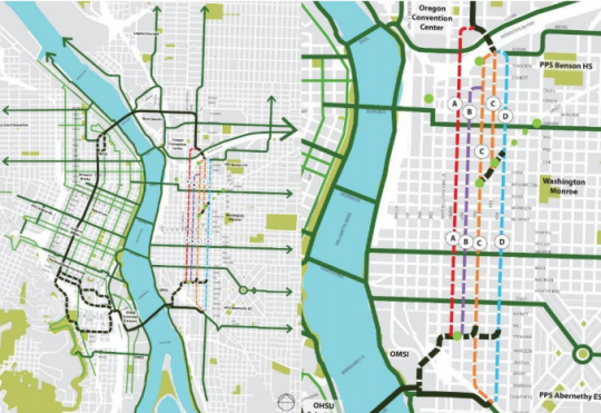
The leading options are, at this point, numerous and intriguing: Grand, 6th, 7th and 9th.
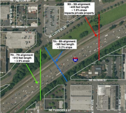
Planners are also looking, in closer detail than ever, at the possible options for a new biking-walking bridge over Interstate 84.
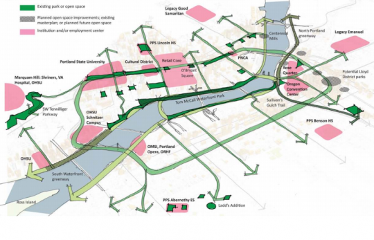
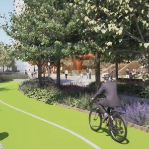
If a route can be built, it’d form the eastern rim of a vision the city started pursing in 2012: a “Green Loop” linking Portland’s downtown and central eastside, from the Broadway Bridge to the new Tilikum Crossing.
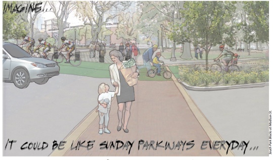
The catch is that all four options being discussed for the Green Loop through the central eastside would require removing more than 100 auto parking spaces.
Options for a new biking-walking bridge across the freeway
Let’s start with the bridge.
As we wrote last week, the potential for a bridge across the freeway is rising thanks to the huge housing projects being proposed in the Lloyd District by American Assets Trust.
Development fees from more than 1,000 new apartments in the development pipeline could go a long way toward paying for this long-discussed bridge that would for the first time connect the street grid across Sullivan’s Gulch.
Until last week, in fact, the city’s transportation bureau had allocated $300,000 in possible revenue from a new transportation income tax to planning the bridge. (That line item disappeared last week and was replaced by planning for protected bike lanes in outer east and southwest Portland.)
Anyone who’s tried to cross I-84 on a bike between 28th Avenue and the Willamette River knows how much difference a car-free connection here would make. And anyone who’s walked on the Eastbank Esplanade would probably appreciate the chance to move north-south bike traffic off that route.
Based on the image above, the lowest-cost option would seem to be a diagonal bridge connecting NE 7th Avenue to SE 8th Avenue.
Four possible routes for an all-ages bikeway south of I-84
This raises the second question: south of I-84, what route would create the best connection to SE Stephens Street and Tilikum Crossing?
And what would the route look like?
Page 32 of the notes from last week’s meeting of the Southeast Quadrant Stakeholder Advisory Committee starts to answer these questions.
Above are two maps of the four options the city has been considering: Grand, 6th, 7th, and 9th. (North of Sandy, part of 8th Avenue might also be used in a couplet with 7th.)
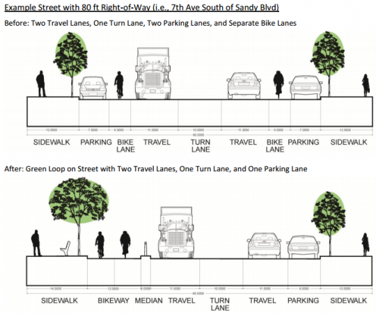
And below are two possible cross-sections for the routes. First, here are before/after shots for a bidirectional 12-foot protected bike lane on the 80-foot-wide 7th Avenue:
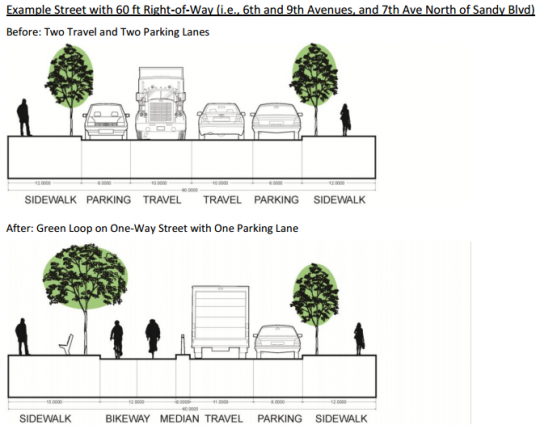
Second, here are before/after shots for the same bidirectional 12-foot protected bike lane on the 60-foot-wide 6th and 9th Avenues, plus 7th Avenue north of Sandy:
City staff didn’t prepare a cross-section for the Grand Avenue, though it was seriously discussed as a possible route at a June design charette. Grand, whose road bed is 56 feet from curb to curb, has by far the most commercial activity and freight traffic, but adding a 12-foot protected bike lane with a buffer would require removing both one lane of parking and one mixed-traffic travel lane.
The city prepared a handy chart for comparing the upsides and downsides of each route:
As you can see, 7th Avenue tops this list thanks to its width, open space opportunities (on vacant lots nearby) and relative directness.
Meanwhile, city staff recommended that Grand be removed from consideration, due mostly to the fact that it’s a major freight route and the city’s working plan is to keep trucks and bikes on different streets whenever possible.
Two options that weren’t discussed in this report:
- 8th Avenue. I assume this is because it’s interrupted by a parking lot between Belmont and Morrison.
- A neighborhood greenway design, with traffic diverters and speed bumps, rather than protected bike lanes.
Advertisement
Interested in more detail? Last week’s staff report has plenty. Here’s their summary of the conclusions they made about each possible route.
Option A: Grand Avenue
The option that best aligned with the concept of using the Green Loop to reinforce the mixed-use corridor was a 2-way cycletrack on Grand Ave. There were several issues with this concept. Both a travel lane and parking lane on one side of Grand would be lost to accommodate the new cycle track. This has significant traffic impacts, particularly at bridgeheads where traffic weaving and new signalization would be required to accommodate left turns. Approximately 100 parking spaces would be lost within the main retail corridor. Additionally, the traffic signal progression on a one-way street means that southbound bicyclists (traveling against the main flow of traffic) would frequently be stopped at signalized intersections.
Staff propose that this option be removed from further consideration. Although this option aims to achieve a more pedestrian and bicycle friendly Grand Avenue where there is the most potential for mixed use, it would have the largest impact on freight movement, the highest costs due to the infrastructure improvements necessary to make it work well, and provides relatively few benefits over other options.
Option B: 6th Avenue
This option is proposed by staff following multiple tours of potential north-south alignments. There are many design options for accommodating the Green Loop on 6th Ave, one of which would be similar to the 60 ft street section provided above. In general, this would require either the loss of one travel and one parking lane, resulting in a one-way street and the loss of approximately 125 on-street parking spaces, or the loss of both parking lanes or approximately 250 spaces.
Staff propose that this option continue to be analyzed over the next year. 6th Ave has many features of a unique place, with historic buildings, comfortable street width and scale, and a growing list of new development and building rehabilitation projects that show market interest. Its location exactly in the middle of the district makes access to all parts of the district easy. Mixed use zoning (EXd) lines the western side of the street. Stormwater improvements likely to be included as a part of the Green Loop would help to overcome known street flooding problems along much of 6th Ave.
Option C: 7th Avenue (With Potential 8th Ave Couplet North of Sandy Blvd)
This option was discussed during the Transportation Working Group meetings. This is the only option that includes a segment with 80 ft right-of-way width. While 7th Ave was identified as a secondary freight route by the TWG, it already has two bicycle lanes. As shown in the street section above, the Green Loop would result in the consolidation of these two lanes to one side of the road. For this portion, the loss of a single lane of parking would result in approximately 125 fewer parking spaces. As with 6th and 9th Avenues, north of Sandy Blvd, this alignment would be carried on 60 ft of right-of-way and would result in additional losses of parking or travel lanes similar to those options.
Staff propose that this option continue to be analyzed over the next year. 7th Ave provides an alternative to 6th Ave. Both are near to the same retail, commercial and residential areas, but where 6th Ave reduces auto access to create a more comfortable pedestrian and bicycle environment away from priority freight routes, 7th Ave consolidates and protects existing bicycle lanes on a large corridor with considerable freight activity.
Option D: 9th Avenue
This option was discussed during the Transportation Working Group meetings. Since 9th Ave has the same roadway width as 6th Ave, the same design options apply here. It is estimated that approximately 125 parking spaces would be lost if 9th Ave were converted to a one-way street, and approximately 250 parking spaces would be lost if both travel lanes remained (but neither parking lane did).
Staff propose that this option continue to be considered as a backup if other options are not supported or are determined to be unfeasible. The Bicycle Plan for 2030 designated both 7th and 9th Avenues as future bike boulevards and there is a proposed signal at 9th Ave and Sandy Blvd that would improve that crossing. This alignment also has the most direct access to neighboring areas to the south. Significant issues to address specific to this route include: (1) How the Green Loop can coexist adjacent to Franz Bakery and other major freight users, (2) How to connect to the proposed 8th Ave bridge over I-84 given the steep climb on NE Glisan St, and (3) Identification of potential amenities it could connect because it travels through the fewest mixed use areas and opportunities for open space.
Want to get involved? You can learn more about the city’s Southeast Quadrant plan here.
Thanks to reader Ian for the tip.




Thanks for reading.
BikePortland has served this community with independent community journalism since 2005. We rely on subscriptions from readers like you to survive. Your financial support is vital in keeping this valuable resource alive and well.
Please subscribe today to strengthen and expand our work.
those aren’t all-ages/all-skills cross-sections… I see motor vehicles within a few feet of cyclists…
if we want-all-ages then we need at least a 6′ physical buffer that’s nearly impossible for a car to cross… we need separate light signal phases for bikes, with no turn on red for cars at all the intersections…
an all-ages route needs to provide a ride where you’re never within 6′ of moving cars at any time… and the speed limit on those roads (and preferably the streets they cross) needs to be a max of 20 mph…
I don’t see us getting a decent all-ages bike route anywhere in the city within the next decade…
“a 6′ physical buffer that’s nearly impossible for a car to cross”
i guess danish cycletracks and dutch cycle paths are now unsafe infrastructure that discriminates against the 8/80 demo.
I’d have to say it depends on the nature of the physical barrier proposed. Options on 6th and 7th avenue have a small space buffer, yes, but if this barrier were a solid fence and not simply plastic bollards, that would go a long way to creating an all-ages lane.
The real problem with 6th ave, however, is the crossings on Morrison/Belmont (5/6 lanes?), and Hawthorne/Madison. Option C takes care of this issue with traffic signals.
A Jersey barrier fits in a 3-4 ft width.
Fascinating.
But I’m left wondering why the right hand (this case: continuous route, mode separated, new bridges, removing auto parking) is apparently unaware of what the left hand keeps doing (23 jigs and jogs on the 20s bikeway, kowtow to onstreet carparking Gestapo, mealy-mouthed excuses for just about everything)?
Couldn’t we expect a more consistent philosophy when it comes to this sort of thing?
I agree with you that the terminology might be lacking, but for what you are describing, Spiffy, the esplanade is really close. I was under the impression this was supposed to be a separated route that also has access to stuff like “shopping” and “destinations”, which means it can’t be completely buffered from the world.
the esplanade is not a bike bike, it’s a multi-use path, with means constant conflict with pedestrians… it’s also not a stable platform…
Can we get the Sullivan’s Gulch trail already, too? The east side needs better connection to this central city infrastructure if it’s to be useful.
What jeg said! The synergy between a new bridge and a Sullivan’s Gulch trail (bike freeway!) is huge. We wouldn’t build one in such a way as to block the other, would we? Would we?
The Key is the 7th/8th Avenue bridge over the Gulch; got to nail that down. Continuing south on the same streets, Option C, looks like the winner. But how does the south end connect to the new Tilikum Bridge? over or under the UPRR mainline?
The depicted alignments seem biased. Perpendicular to I-84 is the shortest, so least expensive crossing, but only one shows such an alignment. Any of them could be depicted that way. So instead of (N-S) 7th-7th, why not 6th-7th? Its about 350 feet vs the next shortest 380 ft.
There are two options. The main idea (for the 7th or 9th street routes) would cross the railroad at the (new) crossing between 8th and 9th: http://goo.gl/maps/nCbVO
The other route, showed as a dashed black line, would follow the streetcar tracks; this would require widening the streetcar bridge over the railroad, and would be more expensive.
They should have studied 8th with the other alternatives. 8th is direct route between I-84 to the UPRR and it is a lot quieter than 7th south of Stark. Sure, the City would need to re-acquire the right-of-way they vacated between Morrison and Belmont (adjacent to Grand Central Bowl), but that shouldn’t be a fatal flaw to considering 8th.
Good to read there is progress happening. I don’t take the Esplanade as it’s too dangerous as a cyclist without separate bike/walk areas and would take 7th to Lloyd then up 9th and over to 12th then it’s just a CF getting around, and coming home up 12th is a nightmare. It’s basically meant I take a Car2Go over to SE 🙁
All I want is a Banfield Bike Bridge. The 11th/12th/13th/16th Dr./Lloyd Blvd./84W exit mega-intersection is insufferable. The stoplights are gruelingly long and always-backed-up car traffic makes biking through here quite perilous.
The City is close to finishing up a new green street and safety improvement project along SE Sandy Blvd between 9th and 8th.
SE 9th and Sandy has a newly constructed diverter and combination bike and pedestrian island refuge.
bidirectional protected bike lanes are deeply flawed infrastructure.
http://www.copenhagenize.com/2014/06/explaining-bi-directional-cycle-track.html
two conventional buffered/enhanced bike lanes would be a better option and would provide space for better infrastructure in the future.
Although the article has no research (that I saw) to back it up, I actually prefer uni-directional paths. The impetus for bi-directional tracks is saving space, and I think there are places where this might fit. However, I would much rather have a narrower path than a bi-directional one adjacent to traffic. That leaves us with a problem: How do we change 7th ave without taking out the other parking lane?
Ha! Easy. Look at the current cross section for 7th. Take out a parking lane (already proposed) and that gives you 7 feet. Both (buffered) bike lanes are now 8.5 feet. Now move those bike lanes to the curb and protect them with things that are not bodies.
Removing parking from one side of 7th and expanding the bike lanes on either side of the street seems best to me. The bi- directional idea is too fraught at intersections
While I agree that uni-directional cycle tracks are better, it’s hard to look past the epic smugness emanating from Mikael Coville-Anderson.
Nobody more than I feels that way about Andersen, but even a stopped clock is accurate twice a day.
He’s not wrong, but nobody likes a gloater. The fact is that the political environment in the US is just not as willing to implement good bike infrastructure as the Netherlands or Denmark, and simply stating “just build Danish-style bike infra” is not enough. We need to address how to actually get the political will to build first.
It seems like his principal objection to bi-directional cycle tracks is that they are often very narrow. The cross sections shown here are 12′ wide with a 2′ physical barrier.
increased risk of injury collisions/crashes — especially at intersections. there is a link to an oecd report in mikael’s post. it contains a good summary of why these facilities are not standard practice in europe.
I agree. If they go with 2-way cycle track ($$$), then they should close the non-collector intersections.
Sad to see the city already removing the Grand Ave option. As the area continues to develop there will be many additional destinations for cyclists along that corridor and right now it’s in sore need of some (any) bike infrastructure, especially considering the streetcar track hazard. It’s important to remember that one of the most popular locations for bike crashes on tracks is MLK/Grand.
It’s worth noting that MLK and Grand are both listed as Major City Bikeways from back when the TSP was last updated. I wish such a designation would compel the city to make a bikeway on MLK/Grand work, rather than coming up with new ways to convince us that a bikeway would be a bad idea. Build it!
This article got me thinking more about tunnels… and how they can be easier for crossing things than bridges, which have to go up, up, up.
http://www.aviewfromthecyclepath.com/search?q=bridge+tunnel
A bridge over I-84 would have pretty shallow grades. A tunnel under I-84 would be extremely expensive and need to be very deep, and therefore have very steep grades.
“ALL-AGES” … hear, hear. I’m pleased to see this phrase getting more use as it relates to facilities that make bicycling more comfortable and feel safer for the elderly, for children riding alone, for adults carrying children aboard their bikes, and for small children riding along with adults.
Your past comments on this subject have been heard. 🙂
I owe somebody a beer :^) …and I look forward to buying a beer for the first PBOT staffer to use that phrase in their published communications.
6th would put the bikeway very close to the retail businesses on Grand, which is desirable.
Agreed. When I read through this report a few days ago, my initial reaction that 7th would be the better choice, as it a) is already an established bike route and b) aligns with the bridge better. However the zoning along it is industrial for much of its length. As well as being closer to Grand/MLK, 6th also has mixed use zoning on one side, with much more development potential. It already has a number of bars and restaurants (Ristretto, Rontom’s, Cooper’s Hall, Voicebox, Trifecta, etc).
With established retail parking demand…..
Somebody should save a hunk of the old Sellwood Bridge for that I-84 bike/ped bridge.
Or we could spend a bit more and build something that won’t collapse in a moderate earthquake.
The Green Loop idea is wonderful, but I just can’t get excited about any of the options (especially since the parking lobby would prevent the obvious solution on 7th from ever happening). Unless there’s actual physical separation throughout the corridor, we’ll never get cycling rates to increase substantially.
How about doing what we should have done long ago: dismantling awful, noisy, outdated I-5 and opening up that corridor to billions of dollars of *people-friendly* development? Just let (hopefully a partially capped) I-405 be the new I-5 through downtown. We removed the west-side riverfront freeway, and it’s long past time to do the same on the east riverfront.
It would offer incredible (and peaceful!) downtown views across the river, and we could finally get a world-class cycle-only corridor that is TRULY safe for everyone, rather than screwing around with trying to retrofit unappealing CEID streets and continuing to think that putting cyclists inches between impaling doors to the right and swerving, fast-moving, increasingly distracted car drivers to the left is ANY way to encourage cycling.
Plus, this way we wouldn’t have to bow to the car-parking gods. We’ve seen over and over and over again that we just can’t make any progress on this front. So, let’s go dramatic (for the first time in 40 years): tear down I-5! It’ll also encourage people to move closer to downtown, thereby cutting down on sprawl (the prime effect of creating interstates through downtown!).
Interstates were designed so that people could drive hundreds of miles *between* large metro areas. They were never meant to be built like crazy *within* cities, where they end up encouraging hundreds of thousands of people per day to clog urban cores with cars. And yet we still haven’t learned the law of induced demand after all these years…
Plus, we STILL don’t realize the high cost of free parking that Donald Shoup has pointed out so very clearly over the years. Sigh. In honor of this week’s 25th anniversary of the Berlin Wall’s fall: “Tear down that freeway!” 🙂
I absolutely agree that I-5 should be torn down though all of Portland, and I-205 be re-signed as I-5. The waterfront would benefit, N/NE neighborhoods would be more connected, and we can finally get rid of that mess of highway overpasses near the Rose Quarter.
Good luck convincing people that an I-5 teardown is a good idea. Such a radical idea won’t go over well – even though the benefits would be astounding.
Tearing down I-5 would massively improve the waterfront, but it wouldn’t actually solve the problem the Green Loop is trying solve: a high quality walking/biking loop away from the river.
That’s a very understandable response, and it’s precisely why I wrote the follow-up immediately below my I-5-removal comment. I strongly believe that removing I-5 on the waterfront would have have a massive cascading effect, resulting in the creation of people-friendly redesigns on numerous parallel east-side routes, including overly wide streets such as 7th (and, again, the embarrassing and by far easiest-to-fix car-dominated mess we have on Broadway/Weidler, in which people just speed by all the retail on their way somewhere *else*).
I know that this central link is not at all about removing I-5, but I just wanted to bring it up and dream big! Just imagine what it would do for the *entire* east side–not just along the river. I absolutely believe that it would lead (in MUCH less time than we’re currently projected to witnessing) to meaningful change on east-side streets as far inland as 82nd and beyond!
PLUS: once everyone sees the downright heavenly people-friendly corridor that results from ripping out I-5, momentum will increase 1000-fold for creating Dutch-style protected cycling corridors on parallel streets like 7th. The parking lobby will be overpowered so quickly that their heads will spin right off, and our initial (admittedly very, very expensive) investment would pay off in the long run many-fold–with a corresponding immeasurably better quality of life (and public health).
Vancouver’s world-famous (former chief city) planner Brent Toderian talks all the time about the “counter-intuitive” nature of designing for cars and particularly for urban interstates. He loves that Seattle’s tearing down the viaduct, but he’s bummed that it’s all being replaced with the insanely expensive and, in his mind, *unnecessary* tunnel.
Brent Toderian would be ALL for removing I-5, as would be literally every other famous transit/planning visionary I know, such as DC’s Jeff Speck, Auckland’s Darren Davis, Chicago’s Yonah Freemark, NY’s Ben Hecht, and Minnesota’s Charles Marohn, among others. Many presentations and articles they’ve authored are easily searchable for those not familiar with their phenomenal work. Here’s just one example from a talk Mr. Toderian gave in Seattle:
https://www.youtube.com/watch?v=uTsuBUQ33U4
As you all know, other cities are now leapfrogging us in a number of ways, cycle-infrastructure-wise. The next transportation area in which we’ll be caught asleep at the wheel, so to speak, is freeway removal. We were the very first city to *intentionally* remove a downtown freeway (again, the early 70s is truly the last time we led the nation in so many ways), but other cities are catching on. Look for it to happen in many cities before long: Buffalo, Rochester, Syracuse, New Haven, Boston, New Orleans, Dallas, Perth, Sydney, Seoul, Seattle, Milwaukee, New York, Cleveland, St Louis, Detroit, Denver, Chattanooga, Providence, Trenton, Madrid, Rio de Janeiro, Oklahoma City, Toronto, Montreal, Tokyo, and many other cities worldwide are either considering removing downtown freeways, in the process of it, or have completed such a removal.
And in EVERY case done so far (e.g. San Francisco, Milwaukee, Seoul, Boston, Oklahoma City with its beautiful new Bricktown neighborhood, and obviously our own PDX), it’s been SOOO very worth it. 🙂
100 parking spaces….well that’s not gonna happen if the 20’s bikeway was any indication
Why not a ‘business greenway’ on 6th between NE Davis and SE Division with turnouts between major streets and signage to let people in cars know that, for example, they cannot go from SE 7th to SE Grand on SE Oak.
The 2-way cycle track design forces behavior and intersection design that people aren’t used to. It will also require changes in signal lights and cycles. Why not use the investment in signals to channel bike traffic on 6th Av. across major streets, with motor vehicles only turning right?
Any of the proposed designs will affect the way that delivery trucks approach businesses in the area. It will be an easier sell if designers work with each business to make sure their needs are met. No doubt they do that anyway.
Nice suggestion, Robert! BikePortland (Jonathan, Michael, Lillian, Elly, Cathy, other past & present writers/contributors, etc, and the “commenting community” LOL) has the BEST set of minds! Is City Council listening? 🙂 Or even taking a little time to read the comments (that are, thankfully, 1000 times more civil than those on the Oregonian?). I love getting wonderful, encouraging feedback from PBOT when I write them, but can we really take things to the next level–one that will greatly benefit *all* road users, including those who drive exclusively? Like many of you have said, actions from PBOT and City Council (and Metro, etc) would be SO much better than just saying the right thing–not that any individual or even large organization is to blame for our stagnation in progress.
Anything else we can do? How can we get the word out to the general population, who, very understandably, doesn’t have time to think about road diets, zoning issues, people-friendly infrastructure, the multitudes of impacts of urban freeways, etc? For most people (that don’t read BikePortland), it’s clear that removing (even a very small amount of) auto access and car parking sounds terrible. I honestly don’t know how to convince enough people of the benefits that it becomes politically safe to do so. If we could somehow convince Clackamas County officials (particularly John Ludlow) to see the benefits of people-friendly design, it would be the biggest possible breakthrough. I rarely write suburban county commissions, though; I’m honestly scared to, for fears that they’ll dig their heels even more into their positions.
Countless studies are proving now, more than ever, that building world-class cycling infrastructure is a win-win by every possible measure. But I think that the main stumbling block (much more than the $$ in most cases) is the staggering lack of the political will, especially in Portland (of all places!!). We were SO brave in the early 70s on a number of fronts. Maybe such boldness is not possible in this political era. But the facts continue to mount heavily on our side. We’re NOT anti-car; we’re all about safe movement of a growing number of people in an ever-growing city. It’s literally impossible to expand the roads enough for cars. In fact, they only get *more* congested if we do that–and the costs (not including unimaginably high costs to health, quality of life, stress, etc) are SO much higher (especially long-term) when you build exclusively for cars & trucks. Why doesn’t our elected leadership see this yet? I guess that’s what gets me down the most and keeps me up late at night emailing everyone I can–maybe one day including some super entrenched car-addicted suburban commissioners if I can figure out the right approach that addresses all of their concerns.
Sorry to continue for so long. I’ll just stay out and read more of your wonderful ideas!! 🙂