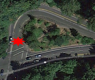
(Red marks the narrow spot that is
currently a safety issue.)
A nerve-wracking and dangerous pinch-point on a heavily traveled section of SW Terwilliger Blvd will be the site of Portland’s newest separated bike path. The location is the northeast corner of the intersection of Terwilliger and Capitol Highway (map) — or what is affectionately known by some local residents as the “teardrop”.
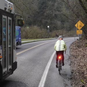
This small parcel of land is managed by the Portland Water Bureau and they’ve sought changes to it for years due to problems large truck and bus operators have negotiating the curve it creates on Terwilliger. The curve is also quite dangerous for people riding bicycles because it narrows the road suddenly and there’s not room for a large motor vehicle and a person on a bicycle to fit side-by-side.
Back in 2012, I highlight$ed this intersection in my ‘Ride Along’ with a family from the area. Barbara Stedman, who bikes through this intersection nearly every day with her young daughter and husband, told me it was a serious safety concern — and she nearly got squeezed by a truck right before my eyes.
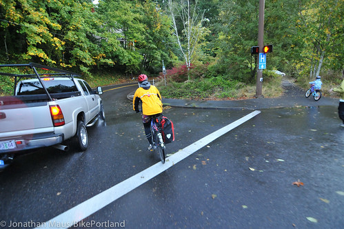
(Photo by J. Maus/BikePortland)
Enter Keith Liden, one of Portland’s most effective and experienced citizen bicycle advocates. Liden is well-known at PBOT and at City Hall for his southwest Portland bike advocacy (often aided by other advocates via the SW Trails group). Last fall, when Liden got wind of a Portland Water Bureau project that would trigger changes to the teardrop, he immediately checked the plans to see if they’d given any thought to bike facilities. Worried that they hadn’t, Liden’s next call was to PBOT to tell them this was a golden opportunity to fix a glaring bike safety issue. “Several of us in southwest made it clear that the design was deficient and bikes needed to safely accommodated,” he shared with us via email.
About a year later, Liden checked back in and realized that the Water Bureau project was still on schedule, but that PBOT hadn’t given the bikeway issue any thought since last year. So Liden, a transportation planning consultant by day, took the issue into his own hands (which he often does). He went out to the site and drew up some simple designs that would create space for a dedicated bike path around the teardrop. He then shared his designs with PBOT and other neighborhood activists.
While everyone seemed to like Liden’s ideas, PBOT told him at the time that there simply wasn’t any money in the budget for the bike path. That didn’t sit well with Liden because he figured that a four-foot path that runs about 200 feet couldn’t cost more than $3,000 to $4,000. He ran those numbers by PBOT, and urged them to find the money. (Note: PBOT says the bike path addition was much more than that, about $25,000 for design and engineering.)
Given the obvious bike safety issues, Liden wondered, couldn’t PBOT find a few thousand dollars “in the couch cushions” to do this project right? Liden even suggested PBOT could use the money they saved when Sunday Parkways in southwest Portland was cancelled earlier this year.
Liden’s advocacy paid off when he got an email from PBOT last week saying that a new bikeway will be constructed as part of the Water Bureau project. It turns out a few PBOT staffers advocated internally for the project.
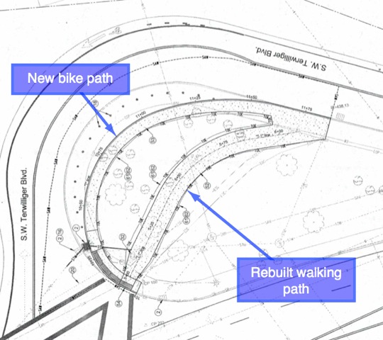
According to the official project design drawings we obtained from PBOT (below), the rebuilt teardrop will come with a new path for bicycles that will be separated from other traffic and will run along the outside edge of the parcel.
In the end, Liden says he’s “very pleased” with the result; but he tempers his appreciation with a note of caution. “With the always grim funding environment, PBOT must take every advantage of installing bicycle facility improvements when they can be included at reduced cost with another project such as this one. We must squeeze the most out of every dollar.” However, Liden adds, “This is no way to run a railroad. This [opportunistic approach and coordination between city bureaus] should be automatic behavior – not something driven by a citizen complaint.”
— PBOT says this project is scheduled for completion in summer of 2014.




Thanks for reading.
BikePortland has served this community with independent community journalism since 2005. We rely on subscriptions from readers like you to survive. Your financial support is vital in keeping this valuable resource alive and well.
Please subscribe today to strengthen and expand our work.
Read article title – hoping it meant Terwilliger was getting a bridge over Capital Highway.
This is good too.
Can’t tell if there is supposed to be a barrier or physical impediment causing this bike path to be “separate”.
Is there a link to the plans as they stand now so we can all be watchful for “cost savings measures”?
“This [opportunistic approach and coordination between city bureaus] should be automatic behavior” – In other industries this is called “Doing your job”
Props to Keith for being persistent.
I recall working briefly with Keith when I was at PBOT integrating public comment for the Bike Plan for 2030. I was really impressed with his ability to navigate bureaucracy and public process as a citizen/professional/advocate, so much so that I meant to (though never did!) follow up with him when I moved to Seattle to ask what advice he would give to someone hoping to pedal that awkward line successfully.
I disagree wholeheartedly with the comment above that opportunism and coordination should be considered just “doing your job,” though. Sure, in fantasy land. But we live in a place called Reality, where things like schedule overload, institutional memory/fatigue, and reassignment/reorganization are legitimate factors to contend with. I think it’s really to PBOT’s credit that more opportunities like these don’t slip away. And really, I feel it’s the responsibility of both City staff AND dedicated citizen/advocates to make sure opportunities don’t fall by the wayside.
This is a great story of one citizen making a difference, and I applaud Keith Liden. But PBOT’s knee-jerk “not enough money” reaction is appalling! It’s been hard going around the City budget for a couple of years–I get that–but how could a big safety opportunity be dismissed without any consideration?
I’ve been on a lot of committees around the Portland Building, and in more meetings than I care to remember, and in my experience, it would have taken one short meeting of the right people to discuss Liden’s proposal and generate the very funding idea he identified. The fact that PBOT didn’t bother is really discouraging.
This, really? Over all of SW that is what they pick? YOu can even shortcut through a path if you feel unsafe there.
Barbur/Naito cars turn left heading Southbound into Northbound to get to Ross Island. Very dangerous for all sorts of pedestrians, cars, and bikers, never seen enforced. This should just be concreted off.
SW Virginia Street cars regularly go 35+ mph. Can’t say I blame them, there’s only a few speed limit signs, and they are partially obscured by trees. The speed limit is 20 mph in parts here due to a school.
Naito in general is just a mess. You have bike lanes on the right but no way to really merge to the left lanes to turn safely. I see a lot of Washington plates here that scream pretty close to bikes, I guess they aren’t used to our bike presence, and they are coming directly off I-5 and the Morrison bridge.
That’s all I got for now.
For $4k this is great. I’ve witnessed two car/bike collisions at this intersection. Both times were right hooks into bikes crossing onto or off of the “shortcut path” you describe. Two weeks ago I was nearly squeezed to the curb — with my son in a trailer, no less — while negotiating this corner. (I refuse to use the “shortcut” after seeing those right hooks.)
How can you right hook a bike short-cutting this path? It’s in-between bushes and up on a curb.
In fact, all they had to do was make the walking path that already went through here more bike accessible by expanding it/hardening it.
There were concerns about collisions between fast moving bicyclists and slower pedestrians who use this trail. And the right hooks probably happen when you move off the path into the street. I for my part refuse to use the path because it is just that – a narrow gravel path and I don’t like to go in it at the speed I have when I come down Capitol Hwy.
But there is a bike lane right there. And I thought one of the main reasons for mowing down all that vegetation was to improve visibility.
Paul, are you talking about bikes taking the “shortcut” south and popping out the intersection? That seems like a really bad idea all around. If not, then I don’t see how a car can right hook you when it’s going straight down Terwilliger
I get right hook close calls SB (cars turning onto Capitol) but the path has nothing to do with it, good or bad.
The biggest problem with this gooseneck — which I’ve ridden through every day for a decade — is that bikes have unpredictable lines b/c there’s no lane THROUGH the intersection. This is a great fix.
This is just a goofy intersection all around.
Actually one was a right hook and I’m not sure if the other was left or right hook.
The right hook was a cyclist who was riding EB on Capitol, “boxed” the intersection to turn left (NB) onto Terwilliger (instead of getting into the left turn lane on Capitol and waiting for the next light). The driver at the head of the line didn’t see him do this and didn’t know he was there. They both started when the light changed.
The other instance was ambiguous. I saw this after the event, both bike and car were in the crosswalk near the NE corner of the intersection. Other folks there said the rider was coming onto the path and the driver saw him but turned into him. That rider was badly hurt. He was on a pricey carbon bike and built & kitted like a racer, my read always was that he was coming NB into the intersection really hot on a green light, aiming for the path (to cut the inside of the curve), and the driver misjudged his intention.
This is already a bad corner for left hooks and not having an obvious line where drivers expect you makes it worse.
I also refuse to use the path for the reasons Barbara describes. There are joggers, I’m moving faster than car speed already, etc.
They didn’t “pick” this. It was an opportunity because BES is working there anyway to replace an ageing pipe. So it’s not a new separate project. Remember when Sam Adams takked about using water money to do improvements for bicyclists? I think he had stuff like this in mind, where one Bureau is ripping up the street anyway and the other can tack on. PBOT did a similar thing on SW Maplewood where BES was working on the ditch and PBOt ended up paving and striping a MUP on this street that had no sidewalks so now pedestrians and bicyclists (including school kids from Maplewood school) can navigate this street more safely.
Inaccurate. PBOT thought up applying the BES ditch to swale concept on Maplewood from the beginning of the greenway project and worked with them to get it accomplished. The article is a bit off as well, since PBOT’s concept plans for the issue date back to 2009 as part of a Tri-Met safety review (the buses have been driving onto the inside curb to complete the northbound move, hence the temporary wands).
That may be true, but like many well intentioned efforts, it was not bearing fruit, just like the tear drop fix, it was on a draft plan but there was no will to get it done.
We citizens, SWTrails and Joe and Pam Vanderveer of the disability Commission toured some sights with Mark Lear to assess the usefulness of extended shoulders. where BES had left a gravel. We all agreed the gravel surface was not of a quality to be used for wheelchairs and strollers, people were using the street instead. It was after that we got a firm commitment that paved extended shoulders would be installed. Mark had to negotiate this with BES!
BY THE WAY SWTrails has been working on the extended shoulder concept for about 7 years!
Great job, Keith! This is indeed a harrowing intersection. The curve is too narrow for both a car and a bike side by side, however, that’s exactly the point where a car and a bike meet when both start at the same time at the red light on Terwilliger northbound. And cars don’t believe that they don’t fit. I have resorted to going in the middle the lane, but many drivers either honk or pass me later with roaring motor. Or they are overly “cautious” and pass me in the oncoming traffic lane which is very dangerous as it is just in front of the next blind curve. The irony is that bikes are usually faster through this narrow curve than cars!
I hope that PBOT widens the bikelane on the other side of that curve as well. It is substandard and too narrow for a bike trailer for example. And in rush hours traffic bike come at high speed down hill and have to pass standing cars that don’t manage to stay out of this narrow bikelane in the curve.
“The irony is that bikes are usually faster through this narrow curve than cars!”
My habit NB is to get behind the first car idling at the stoplight. That way everyone behind me can see which vehicle has trouble negotiating the curve.
While I agree this spot is uncomfortable, when I read “obvious bike safety issues” it makes me wonder just how many actual accidents have occurred here?
Please PBOT. Make the path (using the curb cutouts) parallel with the line of travel for both getting off the road and back onto the road. There are several instances around town (E. bound Weidler at Williams, S Bound Greeley at Going come to mind) where the bike lane is awkwardly re-arranged so that is perpendicular to the crossing. This is not ideal.
I hope the bike & pedestrian facilities are clearly labeled so that we can keep everyone separated.
Great work, Keith. And thanks to those PBOT staffers who advocated internally.
Is there a PBOT webpage for this project?
Anything from the government to acknowledge to the public that this exists outside of the reporting on Bikeportland.org?
I doubt it. PBOT does not seem to understand that communication outside their own bubble is a good thing.
What seems most piscine about this whole scenario is that PBOT is allowing the Water Department to make modifications to the transportation realm without any oversight until the a random citizen asked them what for.
I think bikes are usually faster than cars coming into this spot if they’re turning left from downhill Capitol “Highway”, but are usually slower than cars if they’re coming from uphill, northbound Terwilliger on the other side. My usual approach is the former, and I often just hammer it and take the lane, keeping up pretty well with the cars. When I’ve come in the latter way (from the south) I’ve felt a lot less comfortable doing so. This fix wouldn’t be even in my top-10 list of things to improve in SW, but I’m still glad to hear it’s happening.
By the way, IF there is no one walking on the pedestrian path (and there often is), I will often take that shortcut, ride the sidewalk a bit and side-hop down onto the bike lane where it begins. But again, never if there’s already a pedestrian there.
Barbara, you’re welcome. A comment Jonathan didn’t mention is I told him we “need more Stedmans” after he reminded me of the article he posted of your family commute. The city’s Bicycle Plan for 2030 makes the point that the city must have a bicycle system, which appeals to the “interested but concerned.” If the bike plan is to suceed, we must appeal to more families, such as yours. It’s pinch points like these that keep the “interested” group concerned and in a car – not on a bike.
I agree with some of the comments that this project may not be the highest priority. But it is a significant gap on a bike route that is generally pretty good. The question is if the city is going to rip up the street, should it be put back in the same deficient configuration or should we take the opportunity to fix it at reduced cost?
Finally, I understand the new bike facility going around the curve will be grade separated with a curb. When the bike route and pedestrian routes meet north of the intersection, I believe the city intends to mark it for pedestrians and cyclists in a similar manner to the westbound approach to the Hawthorne Bridge, with about 3.5′ for northbound bikes and 5.5′ for pedestrians walking in both directions (existing path is about 9′). The northbound bike route will connect in some fashion with the existing bike lane up the hill without the gap we have currently. Fingers crossed.
SWTrails built the pedestrian path through the tear drop so we could have a safer place for pedestrian traffic and not have to fight bicycles going at a good clip around the curve. We do not want theb bicycles on the cut through route, that is why we have worked with Keith to make sure we have a safe alternative. Good job Keith.
PBOT was informed of what we wanted the final configuratin to look like over a year ago. They choose to ignor our desires just like they have ignored safety improvements that could be part of an upcoming changes on Terwilliger between Chestnut and SW 7th. We could have added an inexpensive strip of asphalt along the west side of Terwilliger outside the existing curb to create a place for bikes where there are none at present.
That apparently has gone no where. From a cinical point of view, the question comes to my mind, does PBOT drag out simple projects hoping the citizen input we suggest will be forgotten about snd the can move forward with their plans? I hope that is not a strategy, but we have several half finished projects in Hillsdale that need to be completed. I wonder if PBOT even realizes that is the case?
As Barbara stated, last year PBOT, due totally to the efforts of Mark Lear, finally got BES and PBOT to agree to work together to convert ditches to walkable and bikeable extended shoulders on Maplewood Road. Federal studies have shown that extended shoulders provide 80% of the safety benefit to pedestrians as do full sidewalks. Guess which one is 10 to 20 times more expensive? That was 7 years after SWTrails began to try to work with BES to get reasonable walkable surfaces when they did ditch conversions. They are still doing them, but I do not see PBOT requiring extended shoulders as a policy. We are missing an important opportunity when we let these city silos continue to do their own thing!
Another November 2013 small victory for pedestrians and bicyclists was was Safeways construction of an extended shoulder on 100 feet of land fronting on an unbuilt right of way between Safeway’s beautiful 12 foot wide sidewalks and the sidewalk fronting the Portland Christian School on Capitol Hill Road & Falcon. Safeway was required to put in a new sewer as part of the new multimillion dollar store, but the PBOT engineer reviewing the original plans simply specified replacing an ugly guardrail that make it very dangerous to walk rather than doing something safer and more logical like no guard rail but with a wide extended shoulder. The safe route to school folks were no help at all. It took getting Commissioner Novick involved to get this simple thing done and finally cost the city nothing other than the (significant) staff time of a key supervising engineer. We now have a walkable and bikable extended shoulder that is safer and looks a lot better. It was interesting that on the day the final asphalt was laid, it was still steaming when 4 cars parked there to go to the grand opening of Safeway. We should not have to raise so much hell to get simple things like these examples done.
Which brings up my final point: extended shoulders need to be posted no parking so we actually have a place to walk andnit an improved parking lot!
“not have to fight bicycles going at a good clip around the curve.”
There is a curb-separated sidewalk all the way around the curve.
Right, the bicycles were using the sidewalk, very legal but not funif you are a pedestrian with a jumpy dog on a leash. That is why we built the cut through.
Between the lack of information on the city’s website about this specific subsection of the overall sewer line overhaul project and the similar paucity of facts on other human scale transportation projects it makes me think we need a live wiki to track all these disparate projects.
It would help in holding them accountable to promises they’ve retcon’d from the official website and might even point to cost saving measures that could be found from simultaneous, consecutive or overlapping project safety issues that would be solved cheaper together.
Hi Jonathan, is there a word or two missing from this sentence?
“(Note: PBOT says the bike path addition was much more than, about $25,000 for design and engineering.)”
I’m wondering what the final cost was for the bike/ped improvements. I’m guessing the $25,000 was just for design/engineering, and capital costs figured in separately.
Thanks to Keith and the advocates within PBOT who helped get the money together. Terwilliger is one of the most beautiful streets in the city to ride, a true Olmsted gem – but that intersection has been terrible.
Haven’t ridden it lately, but does anyone know if any improvements have been made to the section of Capitol Hwy that leads down to Barbur – you know, the part where the bike lane disappears and you feel like you’re going down a freeway on-ramp?
Good news. I saw the crews out there the other day but had no idea this was going to be improved. I’m ready to check it out as this is 1 of my 2 best cycling options from SW to downtown.
BES is driving a 30 or 36 inch sewer under Capital Hwy, total of about 70 to 75 feet, 1 more day to complete. This is coupled with work on replacing a crushed pipe that goes under Terwilliger and down the gully. A combined sewer.
This project will be followed by a major water bureau replacing or changing a 24 inch high pressure line that comes from the Carolina Pump station up under I5 and then goes to the Westwood tank and on up the hill to the tanks near the High antenna.
The work to improve Terwilliger at Chestnut and at 7th will be bid soon, but it does not include adding a bike facility where there is no bike path south of Chestnut, something Keith and others asked for.
Jonathan – your later addition of the 25K for design and engineering doesn’t seem to be an apples to apples comparison to my 3-4K estimate. Disclaimer: I’m a land use planner – not an engineer. My estimate was based on personal experience and some anecdotal information. So it could certainly be significantly off. I was only talking about how much a contractor would charge to install an asphalt path around the curve. I didn’t think any design would be necessary. 25K couldn’t possibly be just for design of the sidewalk. At $150/hr. that would be over one month’s worth of work for one engineer. A sidewalk design to match the designed location of the curb shouldn’t take more than a few hours. I would be interesting to find out what the 25K was for.
This is a classic case of making a mountain out of a mole hill. There used to be a sweet little shortcut across the teardrop. (the little girl in the photo is about to use it). But for some reason it got taken out. Now the city comes up with this wonky solution to a problem that din’t actually exist in the first place?
The Terwilliger MUP has high ped volumes – walkers, joggers, strollers, dogs on leash, etc. Not the place to direct bike commute traffic at this intersection.
I support the design and appreciate Keith’s advocacy efforts.
“Nerve wracking”? Uh, ok. If this corner is nerve racking, you shouldn’t be riding your bike.
Looks like the wor on this has finally started this week!