rebuilt with bike lanes and a new sidewalk thanks
to a $3.8 million ODOT project.
The Oregon Department of Transportation (ODOT) is set to stripe new bike lanes on a one-mile section of NE Sandy Blvd from NE 122nd Avenue to NE 141st in east Portland. Construction on the $3.865 million project begins this week.
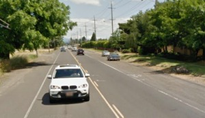
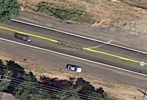
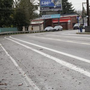
Currently, Sandy has one standard vehicle lane in each direction, with unimproved shoulders on both sides. Cars park in the shoulders, which lack sidewalks or bike lanes and are full of gravel and potholes. The project will rebuild Sandy, making significant changes that include:
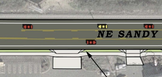
– A center left-turn lane to provide safer vehicle turning movements
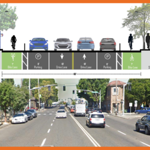
– Two 12-foot travel lanes
– Two 6-foot bike lanes
– One 6-foot sidewalk on the south side only (there are railroad tracks on the north side)
– One 4-foot stormwater facility on the south side only
– Upgraded traffic signals at the intersections of Sandy Boulevard and NE 122nd Avenue and NE 138th Avenue
– Improvements for pedestrians crossing Sandy Boulevard at NE 131st Place, including installation of a flashing beacon
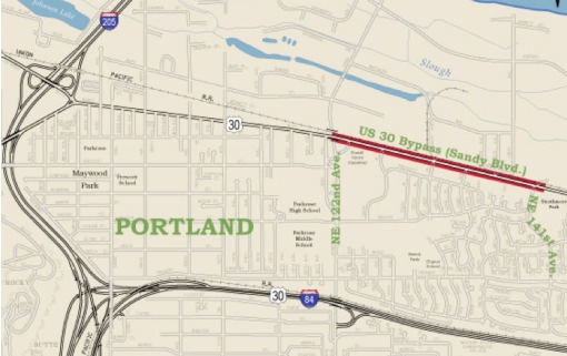
ODOT refers to this as a safey project. Here’s more about the need for the rebuild via their website:
This stretch of Sandy Boulevard (US 30 Bypass) between NE 122nd Avenue and NE 141st Avenue has a high incidence of crashes. There currently is one lane in each direction, with vehicles headed west stopping traffic to make left turns to businesses on the south side of the highway. Congestion caused by vehicles trying to make left turns also leads to rear-end collisions. Sidewalks are missing in most of the project area.
By adding a median turn lane through the project area, vehicles will be able to more safely make left turns. Sidewalks will make it safer for pedestrians to get to their destination. The shoulder/bike lane will give cyclists a safer buffer from motorized traffic.
Here’s how Sandy looks today in this location (aerial view):
And here’s how ODOT plans to make it look when this project is completed:
And here’s the new cross-section:

The $3.865 million project is being paid for through a combination of federal transportation safety dollars and funds from the State of Oregon’s bike/ped program. Completion is expected by summer/fall 2013. See the official project website for more info.
—
And now, a bit of opinion…
While it’s certainly nice to be getting a new roadway and six-foot bike lanes; it’s somewhat disappointing that we continue to build bikeways the same way we have since the 1990s (and before). People will likely drive their cars and large trucks well over 40 mph on this road (35 is the limit). They’ll be doing so mere inches away from people in a bike lane that’s separated by nothing more than a tiny strip of paint. We are spending $3.8 million on one mile of road; we should strive for bikeway access that is equal in quality and safety to driving or walking for people of all ages (which it clearly isn’t in this case).




Thanks for reading.
BikePortland has served this community with independent community journalism since 2005. We rely on subscriptions from readers like you to survive. Your financial support is vital in keeping this valuable resource alive and well.
Please subscribe today to strengthen and expand our work.
I agree that these are far from ideal conditions, though certainly some bike lane is better than none. Now can we get them extended all the way from 122nd to NE Couch and 14th? I almost got doored on NE Sandy and 19th today, very close call. I was thankful no one was passing and I was able to swerve out of the way, but the driver (a white haired woman) and I both screamed in horror/terror as the whole thing was going down.
Agreed. Sandy should be a priority for bike lanes all the way in. It doesn’t make any sense to divert bike traffic so far to the North or South. 84, the gulch, Ladd’s non-grid, and several large industrial blocks make Sandy, which is basically flat till 50th and angled toward Burnside the fastest (by far) route extending all the way out to the 100s. Sandy is no longer lined with Car Dealerships. Those who know and who are moderately experienced ride Sandy. Take the blvd. for ride on light-traffic Sunday. Hell, race someone at a predetermined pace riding Ankeny or Tillamook. You’ll smile.
***Meant Laurelhurst. Not Ladd’s
Whenever I have a dr. appointment in Hollywood and then have to head downtown to work, I always take Sandy. There is no faster, more efficient route. I take the lane when the lane is narrow (Sandy has a nasty habit of going wide-lane and then narrow lane several times).
“Congestion caused by vehicles trying to make left turns also leads to rear-end collisions.”
I thought failing to stop for the thing stopped in front of you because you are (a) following too close and/or (b) driving too fast and/or (c) not paying attention was what caused rear-end collisions.
But what do I know, I’m no traffic engineer.
The congestion caused by the left-turning vehicles creates other hazards for cyclists. I ride this stretch every day, from NE 18th to NE 141st. Cars will typically swerve around left-turning cars and onto the shoulder, which essentially acts as the bike lane now. I will be more comfortable with a turn lane at 141st. I dare not take the lane and stop to make a left turn, for fear of getting nailed from behind by some redneck in a pickup doing 60mph. I usually have to wait on the shoulder until both sides are clear.
This project will be an improvement, but it saddens me that they are not building a sidewalk on the south side AND a MUP on the north side. The speeds along Sandy are closer to that of a freeway than a city street. There are long, straight stretches without signals. To the east, the speed limit is 45, so cars will commonly cruise along at 50-60mph. They continue this practice all the way into Parkrose. This is not a comfortable bike route due to the speeds and proximity to cars, and this project is going to do very little to improve that.
However, I have witnessed, on multiple occasions, mothers pushing their babies in strollers in the gravel on the south side, with cars whizzing by 2ft away. This is appalling to me, and I am grateful that the city is finally doing something to fix it.
It is much easier for traffic engineers to engineer roads that are safe despite the bad behavior of the travelers (regardless of mode of travel) than to change 100% of the bad behaviors.
Does ODOT (or the City) have a policy on increasing the number of marked and enhanced pedestrian crossings in the design phase IF a one side of the arterial sidewalk network is developed? The question arises as pedestrians would need to cross at more locations due to the lack of a sidewalk on one side – in order to get to transit, homes, parking and businesses.
I wish it were easier/cheaper to put in a cycle track – we could turn that 3.5′ storm planter space on the sidewalk side of one direction of the bike lane into 1.5′ of curb/divider/storm planter space on the motor-vehicle side of both directions of the bike lane. That plus some traffic calming might make this street actually a nice place to ride a bike! The facility they’re putting in appeals only to the “strong and fearless” IMO.
If ODOT and PBOT were to install bike lanes on all the main arteries and inner-city state highways (Lombard, Sandy, Powell, MLK), I would see it as a bold first step with little cost other than a new paint configuration in many cases. Having grown up around the area described in the article, I appreciate that ODOT is giving Parkrose and outer Sandy Blvd attention. It desperately needs it; however, since this project is more than a simple repaint job, I do agree that more could have been done with the new installations as Maus has urged.
I did an in depth study of the residential “Central Eastside”….as in the area between MLK/ the river and 82nd, Lombard/Killingsworth and the Springwater. I was attempting to replicate the “East Portland in Motion” plan approved by city council for the closer in four mile wide section of the city with a focus more on bikes. If you emphasize Greenway construction with mostly north-south routes and a few east-west routes in SE you can finish a “grid network” of upgraded bikeways with 44 miles of Greenways and two miles of bike lanes near “the gultch” and the Holgate viaduct.
Retrofitting this whole 30+ square miles of the east-side district would cost about $20 million; that includes a $5 million bridge across I84 at about 7th/8th’ ish. In this grid you would be no further than 5-8 blocks from an upgraded bikeway heading in any direction (85% coverage). I documented every route and used the 2010 master plans for my cost estimates, rounding up for inflation. It could be done really quickly as PBOT’s recent greenway expansion has shown.
Compared to that, this $3.9 million on one mile of road seems to be a significant waste. I am not saying it shouldn’t be done, but maybe retrofitting the current street network first would be more cost effective and benefit more people. Then start expanding roadways and do them in a more separated manner…..a two way cycletrack next to the sidewalk, then the planted buffer and then the roadway…and do it for the entire stretch of road instead of just a small section that leads to a dead end for bikes. This project is not forward thinking even if it does a little to “expand” the bike lane network on the outer eastside.
This road is a major hazard. There are dozens of large apartment complexes on this stretch, housing a very large number of low-income citizens. They all live and walk along Sandy with no sidewalks. I see them walking alongside and crossing high speed traffic without signals. I’m amazed that no one has died here recently.
This stretch of Sandy is part of my commute, if I choose. It is the fastest but after riding from 33rd to 190th all last winter, at night (third shift worker). I look forward to even a bit of improvement in this area. It is flat out dangerous most of the time. I ride this typically about 9pm going to work with a 630am return. When it rains or snows this stretch is the one I dread. I now have three different ways to get home, none of them ideal.
Past about 60th and Sandy, if your on a bike, you are a target for some people. This is my first year in Portland and the two extremes of cycling are very evident to me. Close in, entitled acting, cyclists and those who get away from Cycle Mecca and head out to No Mans Land (far north) towards Airport and Gresham area. Lovely to cycle close in and Downtown and straight up harassment, bottles, cigarettes, food wrappers, whatever thrown at me heading out Gresham way along Sandy/Glisan/Burnside.
Two different worlds…
Long story, Long; I’m glad they are doing this improvement. Hopefully this will defuse a difficult area for riders/commuters/pedestrians.
I totally agree, Jonathan and Terry and others: this is an incredibly wasted opportunity. I’m extremely disappointed that this stretch of Sandy will use outdated painted-bike-lane-inches-from-super-fast-moving-cars technology. At a very *minimum*, the planters need to be the buffer between cars and bikes. This will also force the car and truck drivers to proceed a little more slowly.
Let’s do like they do in Vancouver (BC) all over the place: have the bike and pedestrian lanes border each other! There will be VERY few pedestrians on this stretch of Sandy, so it would make perfect sense to have a bike lane (it wouldn’t even have to be a two-way cycle track) right next to the pedestrian lane.
They have GOT to redesign this stretch of Sandy. The “interested but concerned” group (the vast majority of the population) would never, ever bike on this stretch of road knowing that a single inch of paint separates them from cars traveling at near-highway speeds. Putting 3-4 feet of nicely planted barricades between bikes and cars would make all the difference in the world to this group that we keep failing over and over again to attract. There’s no way we can get our bicycle mode split above 8%, much less 30%, in Portland if we keep thinking this way…
I agree. I have traveled this road by bike many times for commuting prior to a move into Portland and look forward to seeing what is done. There are few choices for an easy east-west ride – the 84 bike path, Marine drive, Sandy, and airport way. Of these I always found Sandy the most direct, actually the least stressful, and the most convenient. It would be good to designate it as a bike route, and plan more ambitious, more progressive changes. I hope they gave thought to traffic calming devices, e.g., sidewalk extensions at cross walks and bus stops. I am afraid that the new black top and new lines will actually increase the speeds as it becomes more efficient to go fast and not worry about pesky left-turners, peds, and cyclists! The bike lanes and side walks also need to extend further east to take in more apartment complexes, small businesses, and homes.
I like to go for Stark/Burnside. Aside from the difficult connection at 181st it’s not bad.
Perhaps the fault lies in this being an ODOT road and not a PBOT one. PBOT changes are focused on making roads safer for everyone, ODOT seems focused on getting cars and trucks through towns at fast, efficient speeds with minimal congestion. Their ‘mission’ is at odds with ped and cyclist safety, which becomes particularly evident when the ODOT roads travel through mixed residential-commercial neighborhoods.
I don’t find the proposed 14′ middle lane very reassuring since it amounts to giving over more of the width of the right of way to cars, and the message it sends to drivers about the width of their highway – sort of the opposite effect of putting a deck with chairs into a parking space on Division. I would think this addition would tend to encourage driving faster than before.
Unfortunately I don’t have any citations here, but I think that a double yellow and no obstacles are all it takes to get people up to highway speeds. Rural two lanes are usually 55. If anything I think that the turn lane will get people to think, “this is a boulevard, not a highway.” That said I would still rather they use the added width for a two lane bikeway.
I thought any new bike and ped facilities were going to be a lot better at this point as well. Dangit. Same ol’ same ol’. The dream of the ’90’s is, in fact, still alive in Portland.
It seems that ODOT prefers the shoulder/bike lane over the safer options because it saves money. If they were to add a second curb or move the south-side bike lane behind the bioswales, they would have to add several feet to the vehicle area to create a small shoulder. Butting the vehicle lanes right up against these curbs wouldn’t be “safe” for all of the distracted drivers that can’t maintain their lane.
ODOT prefers to have bike lanes and cyclists as buffers for inattentive drivers, so they don’t crash their cars into any road features, potentially causing damage.
exactly, plus there is room for pull-offs. Also, it has been shown that if there is a bike lane on each side of the road the pavement lasts longer as the weight from buses and trucks is not near the edge as much, so there is less degradation of the pavement over time. Hence, bike lanes save money long term where a MUP on the south side of Sandy would not only be more expensive, plus needing a northern shoulder, it also would require more street maintenance long-term.
Also, ODOT needs to save $$$$$$ for the CRC.
What theyre actually building is a 4 lane road.
The lanes are 12+12+14.
Bike lanes are 6+6
Reduce the bike lanes to 5 feet….
And now you have enough room for 4 10 foot lanes. What Im sure the plan actually is.
Since there is no sidewalk on the north side of the street, does that make the bike lane a MUP?
Totally agree with Jonathan. It’s like, why bother putting in a bike lane, these changes are for the benefit of drivers.
I drive and bike this section of road and feel this will be an improvement for all road users. As it is now, it’s crappy for bikes, pedestrians and cars. To have some breathing room for all users will work. Yes, it’s not ideal, but wide shoulders work for me – count me as an experienced cyclist. The center lane should keep cars from veering into the shoulder, and create room for the Costco congestion!