
(Image: PBOT/Alta Planning)
At a stakeholder advisory committee meeting of the North Williams Traffic Operations Safety Project today, the Portland Bureau of Transportation (PBOT) unveiled four new options to address traffic safety on the street.
The top-ranking option — the one that project manager Ellen Vanderslice said does the most to address the top outcomes adopted by the SAC at their meeting last week — is a left-side cycle track and one motor vehicle lane on Williams between Broadway and Killingsworth.
Today is the first time this 26-member advisory committee has even considered design options for the street since the entire process was put on pause and re-organized back in June of last year.
PBOT’s “Option 1” (see cross-section drawing below) would separate bike traffic on Williams from auto traffic by using an auto parking lane as a buffer. The cross-section being proposed would include one, 14-foot standard vehicle lane, two 8-feet auto parking lanes, and 10 feet for bicycles. Some of the drawings unveiled today show two separate lanes for bikes in order to allow bicycle riders to pass each other.
Here’s a cross-section of Option 1 when a parking lane is present:

And when no parking lane is present:

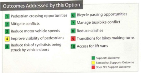
Option 1 would do away with one of the major problems on Williams — the bus-bike conflict that occurs when buses service stops in the bike lane. Below is how PBOT and project consultants from Alta Planning have determined that it stacks up against the SAC’s adopted outcomes:
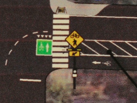
If you’re concerned about how you would turn right while bicycling on the left side of the street, see the drawing below for how PBOT would treat intersections…
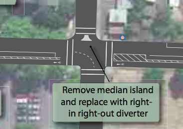
Also under Option 1, PBOT would remove the notorious (and annoying) median at N. Graham that pinches traffic…
(For further reading about the left-side option, see our post about it from April 2011.)
The left-side cycle track option (note: PBOT says they have a “very general” definition of cycle track and that it means basically any type of facility that affords bike traffic significant separation from auto traffic) was just one of four options unveiled today.
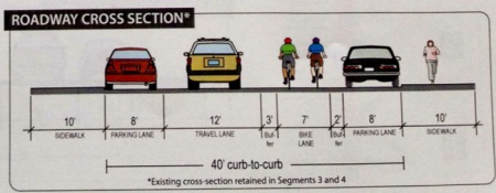
Option 2A would be a right-side buffered bike lane with one standard travel lane between Broadway and Killingsworth. Option 2B is very similar to 2A but it would return to two standard lanes and a standard width bike lane between Graham and Skidmore (the most highly developed/highest traffic segments of the street).
Here’s the cross-section of the right-side buffered bike lane with one standard lane…
Option 3 would leave the street with the same configuration it has today.
All four options also include “spot improvements” like curb extensions (to improve visibility for people trying to cross), rapid flash beacons (crosswalk lights that flash when someone is present), new curb ramps, and so on. Vanderslice also shared today that PBOT is already working with developers to find funding for a new traffic signal at Williams and Cook. That signal is seen as crucial in achieving the desired safety outcomes in this project, but at $250,000 or more it is too expensive to pay for through this specific project (which has only about $370,000 total).
It’s also important to note that, according to Vanderslice, none of the new options would require significant reductions in parking capacity.
Today was just an unveiling of the options and a starting point for the committee to discuss concerns and next steps. Another meeting is set for March 6th.
There is certain to be a vigorous discussion of the options before the SAC makes its final recommendation to PBOT. Already at today’s meeting, you could sense the anxiety among the various stakeholders.
Even before the options were unveiled, Susan Peithman with the Bicycle Transportation Alliance (BTA) shared a recent personal experience. For the first time ever, she shared, she saw a young woman on a bicycle get hit by someone driving a car. It happened right in front of her eyes and Peithman was the first person on the scene. She wanted her fellow SAC members to keep that incident in mind.
Immediately after Peithman spoke, the assistant pastor at Life Change Christian Center (located on Williams), Jarrell Waddell, shared his concerns. Waddell said the spate of new development on Williams only exacerbates his concerns about auto parking capacity.
Toward the end of the discussion, Matt Hennessee, the senior pastor at Vancouver Ave. 1st Baptist Church said, “I’m glad we’re not making a decision today. We need time to reflect on everything.”
PDF downloads
— The four of the options unveiled today
— Overview of how each option would look on the various segments of Williams.


Thanks for reading.
BikePortland has served this community with independent community journalism since 2005. We rely on subscriptions from readers like you to survive. Your financial support is vital in keeping this valuable resource alive and well.
Please subscribe today to strengthen and expand our work.
It would be great to have a forum of just bike advocates who were involved in the committee and came to the many public meetings after the final decision is made to hear what they learned from this unique process.
scott lieuallan and i have been to pretty much all of these from the beginning, and there are several bike advocates on the SAC itself. it might be interesting to do a post-mortem, but right now it is still going on.
the left-side bike lane and single lane of travel are the best ideas yet! let’s hope they stick…
I sort of like option 1, but the issue I see is when parking is present, LEAVING the bike lane to make a turn could be a challenge when it’s full of cars.
Yes, this is going to be a sticky issue. The adoption of cycle track style bikeway designs is going to change the way people bicycle in Portland. Turning off of these facilities can only be done at designed turning areas, and merging into the general lane to turn will be limited.
Meh, yeah. Two steps forward, one step back.
I get that this is a “transportation corridor” that is being designed, and not a sightseeing route, but sometimes I wonder about these design decisions.
Personally I have no problem moving in and out of traffic and signalling my intent, but I’m not everyone. Hopefully this will convince “more” people to take to the route, in addition to the ~3,000 that already ride it daily. After riding through the PSU cycletrack a few times I don’t really care for it.
Also, I dislike “having” to have parking on both sides of the street. The reality of urban living is that you can’t always park right in front of your destination, sorry. I live a few blocks away from a large concert venue, and on concert nights I sometimes have to park a few blocks away from my own house, as it doesn’t have a driveway. Oh well, not a big deal.
I <3 option 1. Left side buffered bike lane. Kudos to the SAC!
Left side bicycle lane, buffered from motor vehicle lane, with single motor vehicle travel lane.
Make it stick!
I don’t get it, did Vanderslice says at today’s meeting that none of the NEW options would “significantly” reduce on-street parking?
If yes, then why is Waddell saying he is worried about parking capacity?
It sounds like the new options will have *some* reductions, though not “significant” reductions. How many parking spots are we talking about and where?
It would be nice to have a clear sense of how many parking spots the fight (or concern) is over?
Is it something like…
8 parking spots vs. safer bicycle/peds facilities
I find it odd, perhaps unsettling (if the reporting is accurate), that immediately following someone stating concern over the safety of bicyclists, someone counters with their concern for parking capacity.
A parking capacity that is only really impacted on certain days of the week, whereas bicycles and peds are riding there around the clock, 365.
I am hoping that parking is removed at each intersection, those spots right at the corners that you can’t see around? That’s my hope! Improved visibility for those turning and those trying to cross.
there are six curb extensions in each of the plans, but i have not heard that there is any intention to push parking back from the corners.
It is strange that a church (Which doesn’t pay taxes) would ask for additional on street parking (Which is subsidised by tax payers) instead of paying for a parking lot themselves. Also, if church goers had a safe way to get to church (Making Williams safer for walking/ biking), it would free up their little parking lot for the folks who need to use it.
Indeed, build your own lot with all the money you save not paying taxes…
The people who drive to church pay taxes. Moreover, many of the people who attend church in this neighborhood used to live here and walk to church, but the rising cost of housing here pushed them out of the neighborhood.
This is the kind of rhetoric that is not helping move things forward. I live in this neighborhood and really want improved bicycle facilities–criticizing pastors is not the way to get that.
Well, many of those same churchgoers can no longer afford to live in the neighborhood where they still worship, so biking or walking for them isn’t an option. The affects of gentrification on predominantly African-American houses of worship has been quite severe.
Option 1 looks fantastic to me. Hopefully the community comes together to recognize the obvious benefits.
It is very possible to make right-side cycle tracks that do not have interference with bus stops.
It would look like this:
http://www.flickr.com/photos/jamesbondsv/6245994983/
something like that was under consideration months ago, and there may be ways to put it back on the table. PBoT and ALTA are taking feedback from the SAC over the next couple of weeks. e-mail susan peithman at BTA or steve bozzone or ben foote or alan rudwick or someone else on the SAC who might pass it along.
This is a one-way corridor, so there is absolutely no reason to do this type of design when you can simply make a left-side cycle track. For one, this design is way more expensive to construct (extra concrete). Two, it still has conflict between bikes and bus passengers, and three it solves a problem that doesn’t exist with left-side cycle tracks. The same should be said for any right-hand bike lanes on one-way streets. There is no reason to force bikes into conflict with buses. NYC constructs left-side bike lanes as the standard, especially on bus routes, unless there is a good reason not to. It frustrates me to keep reading about right-side bike lanes being proposed on one-way streets with buses. The only reason for it that I can see is tradition, and that is not a good enough reason for me.
Well said. A solution in search of a problem. Although the eastbound Hawthorne bridge stop desperately needs that sort of treatment. Finding a way to macguyver that sort of design onto the sw 1st & Madison bus stop right before the bridge would be swell, too.
that kind of depends on whether most cyclists leaving williams are heading left or right. not sure anyone has done counts on this. also there is the problem that a lot of traffic entering williams on the way is coming in from the left, which means a left side cycletrack is vulnerable to those intrusions.
i guess what i am saying is “one-way corridor” is not a complete description of all relevant considerations here.
Good point about cars turning onto Williams. I hadn’t thought of that, and I can see your concern about them inching out across the cycle track to check for other cars before making the turn. I see cars that very thing all the time in Montreal. IMO, it’s mainly annoying, unless you’re going really fast on your bike or if a car jumps out across the cycle track. Higher cycle track use, signalized intersections, and Right-turn-on-red bans should help mitigate this problem, though.
Not at the $370,000 budgeted for this project, but I like the idea.
What does “buffered” look like? I don’t want to be trapped in there.
I’d prefer to have the option to be in the car lane if need be.
the buffer is just a couple feet of striped paint, no barrier.
note re the turn boxes on the left side cycletrack option. these would not be at every intersection, by a long shot. the “option 1” drawings they distributed today showed turn boxes at tillamook, russell, morris, shaver, skidmore, going, alberta, and killingsworth. everywhere else you would be on your own, and you would be coming across a line of parked cars to get over to the right. so as a practical matter you would probably opt for a reverse copenhagen or just take it to the next intersection that had the box.
Clever idea, using parked cars as a buffer for the door zone, I mean cycle track. Yeah, I’m a little concerned.
Minneapolis used to have a two-way bike lane on Hennepin, down the center of the road. It was all kinds of crazy, especially since it wasn’t exactly a two way street, but it was impossible to get doored or a right hook.
They changed this by moving traffic one block west, with parked cars to shelter the right-side bike lanes. Cool, now you’re in the PASSENGER door zone, where nobody looks when they open a car door, and you surprise anyone turning right.
The Williams idea is better, but I don’t have to like it.
Rather than a bike ‘passing’ lane I’d prefer to just see one wide lane and reduce cluttering the facility with a dashed line and bike symbols for each lane. I’m not sure how that design would be used in practice but it seems a single 10ft cycle track/bike lane would accomplish the same thing and be slightly cheaper as it wouldn’t need as many markings in the facility.
I would like to recommend doing a “Community Accord”, a tool we used in Vancouver (WA) during our first road diet with bike lane (the ex-SR501 truck route – West Fourth Plain) – it was very controversial among the stakeholders (Port and even inside our Transportation Services Dept). It helped give a design layout time to show that it was effective and safe without as great of harm as some thought.
Basically a Community Accord brings all stakeholders into the room to agree (sign a document) to implement important traffic safety designs that may reduce vehicle capacity (freight too), speeds, parking supply and increase congestion…to allow a project to move forward while setting up an open process to revisit any stakeholder’s problems collectively in public after a minimum implementation period.
And this process it used on Williams should have some set benchmarks (bike or pedestrian crashes/ injuries and or number of bike or walking trips) that would trigger reopening the design discussion for the core corridor section, if it is not implemented as a single motorized vehicle lane, as earlier proposed.
Great suggestion, Todd! There is something similar to this going on already within the SAC. We have agreed on 10 of our highest-priority outcomes that generally address safety and reducing conflicts. The challenge may lie in finding agreement on the best solutions for addressing those problems while considering side-effects (e.g. cost, more cars on sidestreets, parking capacity).
The cycletrack options lack sufficient provision for cyclists passing one another.
Nevertheless, these options should prompt the right conversations to arrive at a good solution.
This is about the most dangerous idea to surface yet.
Cars making left hand turns will be blind to bikes riding out in front of them. If you are on a recumpant or a small child then just kiss your lucky stars goodby.
Option 1 still has the potential for dooring, as has been pointed out already, but the buffer should be helpful. Option 2 turns the bike lane into a wonderful place for bus drivers to stop, just like bus 68 does every morning in the PSU cycle track.
Cars have 8 feet of parking, and then a three-foot area just for doors to open, before a 7-foot bike lane. This is a lot different than the current situation, where there’s no buffer at all.
How does option 1 create potential for dooring? I thought there was to be a 3 ft buffer between the bicycle lane and parked motor vehicles?
Option 1 seems to be well-thought out, and 10 feet of clear space is sufficient for passing slower bikes, just don’t hang out in the buffer zone for long (doors open there).
All the other options still put the bike lane on the right side where it conflicts with bus movements. Can anyone explain to me the logic behind this? I know that the downside is that it creates additional bus-bike conflict, but I can’t see what the upside is. Does anyone know something that I don’t?
Just for discussion purposes…a reply to your question…
One “upside” to a right curbside bike lane would be that it is the more typical bike lane placement scenario, and thus where novice commuting cyclists expect to be and where drivers look for cyclists first. And secondarily it also makes using a left side bike helmet mirror much easier than a left side bike lane.
In the interest of debate, I would reply that in my experience, novice cyclist haven’t developed any preferences, and merely expect to bike in whatever bike lane is present, convenient, and feels safest. I also don’t think novices appreciate having to negotiate the same space as buses.
As for bike helmet mirrors, I think that’s hardly a basis for locating a bike lane.
Another commenter has suggested that on streets with a much larger number of driveways, unsignalized intersections, and/or heavy turning movements on one side of the street than the other, that could certainly be a reason for locating the bike lane on the opposite side of the street, away from those conflicts. From what I’ve seen, this mainly occurs adjacent to highways, waterways, and major destinations.
To me, it’s all about reducing conflicts between users. I don’t know the area well, so I can’t make much of a recommendation, but this should be the logic behind how this decision is made, not simply tradition.
Also, thanks for the discussion! This is how we end up with better bike facilities.
I suspect the second and third options are there just to show what makes option one so different. Let folks come to their own conclusions, rather than saying, “There’s only one way to do this well.”
and yet the second and third options got a fair amount of support from some people at the table yesterday, because they do the least to disrupt the existing streetscape.
Another comment regarding the Option 1 designs: Why don’t the plans include ped refuge islands, as is standard practice in NYC along cycle tracks, instead of mere curb extensions. The curb extensions adjacent to the cycle tracks will cut ped crossing distance by maybe 6 feet, since pedestrians will still need to cross essentially a bike lane, a parking lane, and a travel lane. By using ped islands, the ped crossing distance could be cut by 18 feet. Basically, peds cross to the island when there is a gap in bike traffic, then they only cross one lane of traffic, essentially cutting the crossing distance by 18 feet. They are huge improvements for peds, and I believe they may cost less to construct, as they don’t need to match up with existing curbs and may involve less utility relocation. Has there been any push for this, or any reason not to try this?
2nd Ave cycle track & ped island (NYC):
http://g.co/maps/p2scb
And less cost for reconstructing the storm water catch basins.
14ft travel lane seems excessive, a bus wouldn’t need more than 11ft or 12ft, I say give the extra 2 or 3ft to the cycle track where every added foot makes a meaningful difference.
!!I’m really really excited about option 1!! Looking at the PDF, my one concern is that if someone is parked at the spot just before the turn box, someone coming up the road and wanting to take a left turn may not see a bicyclist and try to take a sharp left turn. I don’t think the fact that there are turn boxes only at a few streets is an issue. It’s easy enough to bike back down a few blocks.
Why do Mr. Waddell and Hennessee from the churches still oppose these safety improvements?
We all agree the history of change has been full of racism and lack of process. I think we would all be glad to address the concerns of the churches if those concerns were made clear.
As noted, all the options cause no significant change to the parking needs of churches.
Option #1 is the only one where I’d take my kid. The other options are not a change, and still too unsafe.
If the churches need a few more parking spots that can be achieved by converting some side streets to one way only with angled in, 45 degree nose first, parking.
The side streets that connect Williams and Vancouver could be one way only. This would improve safety and add parking. Eastbound and Westbound every other block.
Bikes in the left side cycle track would have a reduction of being left hooked reduced by 50%, only on the Westbound one way streets that connect to Vancouver.
Not a bad compromise!
But you should have twice as many people turning left on each of those streets, roughly. There will be just as many opportunities to get left hooked, but fewer intersections where it can happen. Seems like a good idea to me.
Its actually state law that you can’t park within 50 feet of an intersection. I could have the # of feet wrong, but they enforced it in NW Portland a year or so ago.
paint a few yellow curbs and people will get the idea
its 20 feet and its not enforced w/in city limits
I have been looking at the full pdf of the proposal and I’m really liking option 1, but with one change: narrow the “travel lane” to 12′ and widen the bike lane to 9′. If a single 12′ “travel lane” is good enough for option 2, then it should be good enough for option 1. What we really need is more room for bikes to pass bikes, especially if we’re going to be “protected” (ie, blocked) by a line of parked cars. As drawn currently, option 1 is inviting riders to encroach into the “buffer”, which is a setup for dooring.
Apologies if someone else has already raised this point.
getting doored is not the fear.
Getting left hooked by cars that are blind to you from the parked cars is the dangerous thing with this proposal