A missing section of the Fanno Creek Trail, nearly a decade in the making, is nearing completion.
The new section of trail will connect from where the Fanno Creek Trail now ends at Denny Road to where it picks back up near SW Allen Boulevard and Scholls Ferry Road.
Tualatin Hills Park & Recreation District (THPRD) initially reported that the trail could be completed as early as December 1st. When I rode my bike to check it out just before Christmas, however, I found there was still a sign on SW 105th saying the trail was closed ahead.
I figured I’d check out what I could see from the edge of the closed section but when I rode on I found the trail kept on going without any fences or barriers blocking it off.

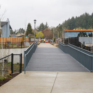
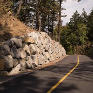
The new section is well paved and provides a fairly direct route between the current end points of the Fanno Creek Trail. It features a bridge over Fanno Creek as well as a series of smaller bridges over low areas which, hopefully, will prevent the trail from flooding as often as it does in other areas.
All of the bridges are constructed of plastic and wood composite boards which look like they’ll hold up well to bicycle traffic and Oregon’s wet climate.

Further on down the trail I met a construction crew putting finishing touches on the trail. They explained that, despite there being no barriers or fences, the trail was in fact closed to the public. According to the crew on site during my visit, construction will be finished and the trail will open on December 30th.
After I visited, one of our readers contacted me to say that as of December 24th the new section trail had been fenced off and is inaccessible.
I’ll be checking out the new section of the Fanno Creek Trail in the new year and will share more once the it is officially open.
If you do try to check out the trail yourself, use caution and be sure to obey all posted signs and the direction of construction crews on site.
Were you able to check out the trail before it was fenced off? Be sure to share your impressions in the comments below.
— Read more Washington County bike news here. Contact Will Vanlue, will [at] bikeportland.org with tips and feedback.


Thanks for reading.
BikePortland has served this community with independent community journalism since 2005. We rely on subscriptions from readers like you to survive. Your financial support is vital in keeping this valuable resource alive and well.
Please subscribe today to strengthen and expand our work.
Forums had you beat again…
http://bikeportland.org/forum/showthread.php?t=4035
That should have had a 😉 with it…
Note: forums are down for maintenance for a bit.
Pester JM;)
They’re back up now…
The linked-to THPRD page says, in part, “The trail project began more than 12 years ago but stalled when a hired consultant ‘was not doing the job that they were asked to do,’’ Hauschild said. The project restarted in 2006 but took years to complete because the district had to acquire needed land from six property owners.”
This shows only one of the problems with MUPs such as this: they don’t rate very highly on anyone’s agenda. If they did rate highly, then why did this languish for 6 years, between the original 12-year ago start and the restart 6 years ago? And why did it take 6 years to acquire the property? Would an important road link languish for 6 years before someone noticed that nothing was happening with it? And would it take 6 years to condemn property for the right of way?
How long before Portland’s Bureau of Environmental Services, or some other government agency, decides that this link would be a useful corridor for some pet project, and they start tearing it up?
Since this topic comes up repeatedly here, maybe we should make, or borrow, an FAQ on The Problems with MUPS? Here’s a start:
1. MUPS are viewed as a recreational opportunity, so agencies such as Portland’s Bureau of Environmental Services (BES) feels free to use the trails as corridors for their projects.
2. People are welcome to walk on MUPS, and walk their dogs on MUPS. That means that often the dog is on one side of the MUP, and the dog’s owner is on the other side, with a leash stretched between. That’s not conducive to riding a bicycle at a reasonable speed.
3. Also not conducive to riding a bicycle at speed is that the MUP was not built with adequate site distances. So there are blind corners.
4. Also not conducive to riding a bicycle at speed is that Inevitably a MUP has to cross a street. These crossings occur mid-block, usually. On-street traffic is not looking for cross traffic in the middle of a block, and probably is not required to stop for bicycle traffic following the MUP. So the street crossing often becomes a 2 way stop for bicycles. See, e.g., Fanno Creek Trail at SW 90th.
5. Gates and bollards to protect the MUP also slow down bicyclists. Again see Fanno Creek Trail at SW 90th. Here’s a google streetview link http://maps.google.com/maps?q=Fanno+Creek+Trail,+Metzger,+OR&hl=en&ll=45.470886,-122.769653&spn=0.012204,0.020278&sll=37.0625,-95.677068&sspn=55.718442,83.056641&vpsrc=6&hnear=Fanno+Creek+Trail,+Portland,+Washington,+Oregon+97223&t=m&z=16&layer=c&cbll=45.470886,-122.769653&panoid=Et6QQrfhwgvZjmT34uEzRQ&cbp=12,90,,0,22.5
I generally agree. It should be pointed out this is a *Beaverton* project. As a commuting corridor the new powerline trail going in to the west seems far better, it’s in an ugly place, clear of trees, and probably wont draw many pedestrians. As far as midblock crossings if you look at some of the ones here in Portland they can be done relativity cheaply. I use the Going crossing of mlk everyday and I’m always impressed with how polite people are. I think with more bikes in Beaverton there will be the same change in behavior. Mayor Doyle seems reasonably competent so I’m quite hopeful for the future. Rod Drake didn’t care about bikes and had far too much power over his 16 years of mayorship. Just the nature of how the city government is organized.
“It should be pointed out this is a *Beaverton* project. As a commuting corridor the new powerline trail going in to the west seems far better”
It is a THPRD project, not a Beaverton project, and it’s part of the Intertwine (http://theintertwine.org). As a commuting corridor, the powerline trail only works if it’s on your route. For me, it’s miles out of my way and doesn’t go anywhere near my regular destinations.
That said, it’s all about options. Don’t like it? Don’t use it. If you want to ride on the road, that’s your option. I for one enjoy having the occasional break from playing dodge car. Sure animials, rollerbladers, skateboarders, and pedestrians *can* be an occasional obstacle, but then so can bicyclists. Relax, slow down, smile. Got to get there fast? Plan for leaving earlier.
As for pet projects, don’t bet on it. This trail is on the border of wetlands, due to limitations on use of such areas, it’s highly unlikely that any project would be allowed to develop it into something else.
Both Fanno Creek Trail and the Westside Trail are MUP’s, but my impression from having ridden them, is that they’re relaxed recreational trails, and not meant to be trails providing for swift travel by bike.
Casual, easy going travel by bike and foot? Yes. Move quickly because I’m on my way to work? No. For swift and fast travel by bike, pressure needs to be maintained on having streets and roads improved for that type service.
can you put a map up? i’m not too familiar with the trail. thanks!
I screen captured this image from the “Fanno Creek Greenway Trail action plan”
from the Metro parks planning page for the area in question.
It does have a published date of January 15, 2003 but I’m having trouble digging up more with the forums down 🙁
K’Tesh: can you speak to the accuracy of the screen cap I made?
Looks about right to me
Here’s a screen capture of the area…
http://www.flickr.com/photos/ufobike/6149004643/
That’s a helpful map! Much better than the cluttered 2003 map too.
Mind if I include this image in the article?
Go for it!
Oh, about the “unfinished section” by SW Allen/SW Scholls Ferry Rd. in front of the City of Beaverton’s Operations Center… Due to scheduled work on SW Scholls Ferry Rd, it has been left unfinished deliberately, and will be completed with that project (rather than being installed, torn up, and installed again).
There is a lot of talk here on BikePortland about designated bike routes and as a (60 year) advocate of cycling, I am in favor of anything that works. But wouldn’t it be better if cars were the minority and bicycles owned the road? All of the money and attention spent on parallel routes is wasted in the long run.
I tire of all the “improvements” from signage and painted lines. And especially the routes that define bicycles as “other”.
True advocacy in the expiring age of the internal combustion engine should be a take no prisoners position on the right of bicycles to rule the road. The roads we already have, not new ones.
Something I’d like to share… Due to various reasons, several spaces are opening up on the Trails Advisory Committee for THPRD in the near future. Want to help get trails? Here’s your opportunity.
Contact: Nicole Paulsen
npaulsen[at]thprd.org
503 629 6305×2710
application:
http://www.thprd.org/pdfs/document387.pdf
I live just south of Denney and 105th and this is totally useless to north bound riders. You travel up and over 217 then have to negotiate a left turn at one of the busiest intersections around. The lights at the 217 ramps ensure you are trying to cross to the left turn lane with traffic to head up 105th. This also make it difficult to get a clear shot to turn left. And there’s no traffic control at 105th.
A better alternative would have been to create usable bike lanes all the way down to Scholls Ferry, where you have a traffic light to control the left turn, and SF already has bike lanes.
Yes I do go to the planning meetings, but this was decided before I moved to Beaverton.
This isn’t forcing anyone to use it. There’s no “Thou Shall Not Ride Your Preferred Route” sign posted anywhere around this project. It is an option. Remember, it’s not just for bicyclists. It’s for everyone to enjoy, or not.
I’d also like to point out that bike lanes are not built from the same pot of cash as this trail was.
Not forced to use it but expected to use it. Once infrastructure goes in the expectation is that you have to use it.
Just look at the article preceding this on, with the unofficial sign saying go use the bike route.
So to create a difficult to navigate option that has an expectation of use doesn’t make sense.
How many article have been on this site about the Hall Blvd crossing of this same trail?
For those going north it’s not great.
It seems to be the intention to route bicycle and pedestrian traffic onto the north sidewalk of Denny for the time being.
There’s a sign on the existing Fanno Creek Trail, south of Denny, indicating a crossing.
That route keeps you on the correct side to access 105th when you’re coming from SW of 217.
You’re completely correct though – 105th and Denny isn’t an easy intersection to navigate.
Crossing Denney on the west side is no better.
Overall the suggested bike route requires crossing a very busy road, Denney, without traffic control. It also requires you to ride on sidewalks opposite the direction of traffic and cross an off and on ramp to 217.
You are better off just turning right and taking Denney to Scholls Ferry and using the lights there.
This is just poorly designed.
Anyone out there help me with a route from from Beaverton TC to Tualatin. I know you can link to it but its takes getting use to, zig zag thru some side streets. Thanks 🙂
Here’s the route I normally take if I’m riding to Tualatin from the Beaverton TC:
http://g.co/maps/dysj9
It’s not the most direct route, but adding a couple extra minutes gets you quieter, car-free paths for a good deal of the way.
Thank you Will 🙂
My route is similar to Will’s, but I opt to keep going on SW Hall a little further. The map’s function didn’t recognize an MUP that’s located parallel to the rail line (sandwiched between Burnham Rd. and the rail). So it got really weird in that area. Basically, you get on it, then turn L on SW Main St., R on SW Tigard St., and keep on it until you meet up with the Fanno Creek Trail (west of SW Tiedeman Ave).
http://g.co/maps/53jw4
The rest of it is as the link shows…
It’s nice to see so much interest in the new section of the Fanno Creek Trail. I work for the Tualatin Hills Park & Recreation District who owns and manages it. We anticipate the trail will open in the first few days of January 2012. Those of you who make it to the eastern part of the new trial will notice that it ends in a (temporary) gravel section. This will be replaced with a permanent paved section when other work in the area gets completed.
In 2012 we will also be installing a system of directional trail signs and maps throughout our service area to help pedestrians and bicyclists find routes between sections of trail and community destinations. As a park district, we are responsible for off-street trails and do our best to connect them to existing or planned on-street bike lanes or routes. With funds from our 2008 bond measure, we’ll be connecting many other isolated section of trails and will add a number of mid-block crossings. Check out our trails: http://www.thprd.org/nature/trails/home.cfm
and
bond: http://www.thprd.org/bondprojects/schedule.cfm
webpages for more details.
-Bruce Barbarasch
Thanks for joining the discussion Bruce!
I’ll clarify something here The FCT is Tigard’s south of SW Scholls Ferry Rd., Washington County owns the section *under* SW Scholls Ferry Rd., and THPRD own the section north of SW Scholls Ferry Rd.