

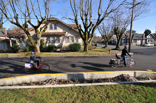
(Photo © J. Maus)
On September 29th, Portland City Council unanimously passed the 50s Bikeway plan, a series of safety improvements intended to make it easier to travel by bike between the neighborhoods of Rose City Park in the north and Woodstock in the south. I had been paying special attention to the process leading up to this vote because the bikeway’s proposed route goes right down my street, SE 52nd Avenue in the Mount Tabor Neighborhood.
“I don’t think it’s worth sacrificing the value of those urban places for the benefits urban freeways might provide, and I say that as someone who enjoys the convenience and speedy thrill of a freeway.”
There’s a lot to like about this neighborhood. It’s one of Portland’s classic streetcar suburbs, with an abundance of craftsman-style bungalows on quiet, tree-lined streets. Few enough cars pass by at slow enough speeds that older kids can play basketball in the intersection, and cats can saunter across the street at a leisurely pace. Within easy walking and biking distance of all this cozy livability — on the main commercial drags where the streetcars once ran — are some of the most inviting cafes, restaurants, and stores in town, along with food carts, banks, pharmacies, theaters, bike shops, a library, and other urban amenities.
The neighborhood benefits from being so easily traversed by muscle power. Residents can save a lot money by not having to drive so much, they’re healthier for doing so, and nearby businesses thrive on the foot and pedal-powered traffic. And of course walkability only adds to a neighborhood’s property values.
Ultimately I was sold on the 50s Bikeway and the benefits it would bring to this place; and it’s most certainly, quite strikingly better than another plan the city once had, which was to put a massive freeway right through the middle of it…
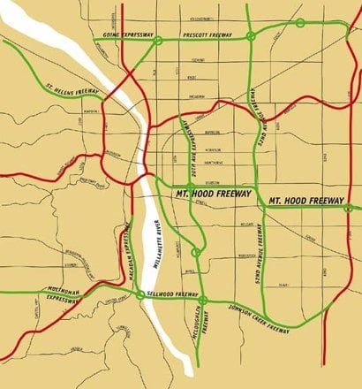
That was in 1966, when the Portland City Planning Commission proposed that a freeway be built along roughly the same route the 50s Bikeway will follow. This freeway was to have been part of a network of freeways that would have criss-crossed Portland.
Development Plan” map
from Portland Planning
Commission showing several
1 freeways that were never built.
I first encountered this nearly forgotten vision of our city’s future in The Portland that might have been, a post by Elly Blue on BikePortland in February 2009. (The map in that story was based on one that Matt Picio found, photographed, and made available here.)
A line on that map describes a freeway that would have snaked a course up along the lower 50s, and then along SE 49th, just a few blocks from my house. The line is labeled labeled: “52nd Avenue Freeway.”
I’m pretty sure this neighborhood wouldn’t be the inviting and thriving place it is today if there was a freeway running through it. The 52nd Avenue Freeway would have cut the quiet residential side of the neighborhood off from the bustling commercial strips on Hawthorne and Belmont. Pollution and noise would have been a constant presence. Many blocks of classic houses would have been bulldozed to make way for this freeway, and the value of the area — whether defined as property value, or the less quantifiable qualities that make a place livable — would have suffered.
The planners of the 1960’s, in trying to make Portland a better place in which to drive, would have made this and many other neighborhoods far worse places in which to live.
And they would have kept some great bikeways from ever having come into existence.
You can see on that old map that on and around NE Going Street — one of Portland’s best bike boulevards, where the stop signs were turned so that bikes can keep going and going at such a steady pace that it almost feels like a bicycle freeway — those Robert Moses-esque Portland planners of 1966 had proposed building the usual kind of freeway: a multi-lane ribbon of pavement they named the Prescott Freeway.
In the southeast part of the map, you can see how much of the land now devoted to the Springwater Corridor multi-use trail would have instead been consumed by something called the Johnson Creek Freeway.
And where SE Clinton, SE Division, and Ladds Addition are today some of the most pleasant neighborhoods in Portland, and are within easy biking distance of some of the most thriving local commercial centers in town (not to mention the SE Clinton bike boulevard), the Portland planners had back in the day decreed that a deep trench replace the blocks between Division and Clinton, and into this trench be poured the six lanes of the infamous Mt. Hood Freeway.
In the 1970’s neighborhood activists and local leaders managed to stop the Mt. Hood Freeway. They stopped it so near the start of its construction that there is an off-ramp to nowhere still hanging from an overpass over the east bank of the Willamette River, an off-ramp that was to have connected to the future freeway.
It was probably only because the Mt. Hood Freeway was stopped that none of those other freeways on the map got built. I feel an endless debt of gratitude to those neighborhood activists for having preserved what have come to be some of my favorite places in the world.
To get some idea what those activists helped save, you just have to look at what was lost. Like in this image,
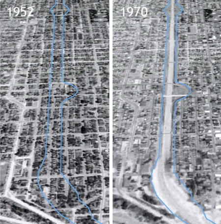
(Image found via Google Earth)
It shows a before-and-after view of the part of North Portland that was consumed by the construction of I-5 in 1956. Everything within the blue line on the left was erased to make way for the freeway. This article in the Skanner community newspaper describes how the freeway paved, “right through hundreds of homes and storefronts, destroying more than 1,100 housing units in South Albina.”
It’s easy to lose sight of the value that gets lost in the course of plowing a freeway through a neighborhood, of ripping a path through the weave of urban fabric made up of many little routes between homes and businesses, and of how doing so disrupts the potential of that place to ever be anything but a conduit for loud and fast-moving traffic.
I don’t think it’s worth sacrificing the value of those urban places for the benefits urban freeways might provide, and I say that as someone who enjoys the convenience and speedy thrill of a freeway. Surface roads are more appropriate to a city, they don’t destroy neighborhoods, they’re cheaper, and within functioning urban places they can do the job of moving traffic well enough that freeways don’t need to be built.
This idea was recently taken up by The Economist:
“Highway construction generated some positive effects and some negative effects. We tend to focus on the positive effects and remark on how constrained the economy might have been without a highway boom. But absent a highway boom something would have been built and markets would have optimised to that something.”
It’s no great stretch to say Portland is better off with the somethings it built in the absence of the future freeways it had once planned.
— This article was written by Spencer Boomhower, whom you might recall as the man behind animated videos that explain the Idaho Stop Law and the Columbia River Crossing project.


Thanks for reading.
BikePortland has served this community with independent community journalism since 2005. We rely on subscriptions from readers like you to survive. Your financial support is vital in keeping this valuable resource alive and well.
Please subscribe today to strengthen and expand our work.
“I feel an endless debt of gratitude to those neighborhood activists for having preserved what have come to be some of my favorite places in the world.” Ditto from me.
You can pay back that debt by volunteering with me to stop the CRC freeway in North Portland.
OPB radio just ran biased news. Please call them or me to help. Joe (503-282-769x where x=2+1
he story
http://tinyurl.com/opbcrc382
contact OPB
http://www.opb.org/insideopb/contactus/
Here’s why the media is full of bias
http://tinyurl.com/arowlist292
This is why I say that maybe the best thing Portland has done for cycling is not doing anything. We really honestly haven’t done all that much to encourage cycling when it comes to infrastructure, but the best thing we haven’t done is rip up the entire city and turn it into a network of freeways. We do have I-5, I-405 and I-84 which all cut through the central city and create major barriers for anyone not in a car, and that’s definitely unfortunate – but we avoided much worse, for sure. Hopefully we’ll remember that when it comes to things like the CRC project and plans to widen I-5 through Portland (dear God, don’t do it).
Dave, you touch upon a tangent I started down in the writing of this article, but had to trim for brevity. Thanks for giving me an excuse to include it here. 🙂
The next freeway boom is coming in the form not of new freeways, but the widening of existing freeways. You’ve got the CRC in the north and the Rose Quarter in the south; both represent expansions of freeway capacity.
But take a look at Google’s representation the typical 8am traffic jam between the Columbia and the Rose Quarter:
http://bit.ly/vy1pHm
The big red line is a parking-lot level slowdown. Note its location: south of the CRC project area and north of the Rose Quarter, throughout most of NoPo and centered around the kink in I-5 where it crosses N Columbia Boulevard.
From what the Google stats show, this stretch already gets worse traffic this time of day than either the Rose Quarter or the CRC project area. So if the capacity of the CRC and Rose Quarter are expanded as planned, what’s going to happen to this stretch that’s already more congested than those other areas?
It’s probably going to be the next place in which massive lane expansion is demanded. And then Portland’s next big freeway-building boom will be under way. Brace yourselves, North Portland residents.
(Note to anyone who happens to come upon this comment months from now, the Google traffic stats I link to might have changed because they are constantly updated averages of daily stats. But as of this moment what I’m seeing is, southbound on I-5 at 8am, a yellow line north of the Portland International Raceway, a yellow line south of around Killingsworth, and a solid red line in between.)
Thanks for that article, Spencer & Jonathan.
Freeways = Racism
really? i mean, really? not everything is class/race based.
The argument is this: For obvious budgetary and political reasons, Freeways tend to go through neighborhoods with low property values and low political capital. The I-5 North of Rose Quarter aerial photo really exemplifies this. The damn thing cut right through the middle of Portland’s most vibrant African American neighborhood. (http://www.ohs.org/education/oregonhistory/learning_center/dspResource.cfm?resource_ID=F4260E3B-A02D-B2F9-8B7EFE4E89DF5400) This isn’t an accident. It was repeated in city after city after city. Sure, the intent may have been efficiency, but it’s a racist system that allowed it to happen. Googling African American (or black) neighborhoods and highway or freeway turns up dozens of these stories!
Great article, Spencer. Thanks! We’re still living with many of the bad decisions made during the 50s and 60s, but Portland made a sharp turn and now is a model for other cities on how to build liveable communities.
One thing that always makes me cringe a little when this subject comes up: The opposition to the Mt. Hood Freeway didn’t make all that traffics go away. In fact, Metro’s (and others’) decisions since then to put large portions of the region’s growth in places like Damascus and Happy Valley have exacerbated the problem.
While there isn’t a “freeway” between those places and downtown, there certainly is a busy and growing stream of auto traffic: Foster Road to 50th Ave, then Powell Boulevard to the Ross Island Bridge. It may not divide the Mount Tabor neighborhood, but it does for the neighborhoods to the south.
This is why many of us have been pressing so hard for a fully funded and robust Foster Streetscape project, which has been stalled for more than 10 years.
Traffic safety is the single biggest obstacle preventing tomorrow’s “Felony Flats” from being as liveable as today’s Mount Tabor is.
Nice work Spencer! I lived in the neighborhood for a time, it’s just as great as you make it out, and would have been a huge loss if the freeway had made it through.
Here’s to hoping we Portlanders decide to designate I-5 on the Eastbank (and the CRC) a “future former freeway” (and former future freeway crossing) someday. =)
Awesome article Spencer! If you want an interesting book to read, check out Big Roads by Earl Swift (covered on NPR). It gives the history of the “great” highway men and their thoughts on how we should build roads. It actually has some good quotes. (http://ridinginreno.blogspot.com/2011/10/understanding-roadway-design.html)
Andy
Thanks Spencer for another fine piece of work.
You must be asking “So how can Metro and others justify the massive expansion of I-5 called the Columbia River Crossing?”
Metro and the City of Portland’s agenda for this century should rather be how do we plan for a Portland without the freeways that should not have been built in the first place. The Eastbank Freeway and Marquam Bridge, two eyesores that have devalued the heart of Portland for 50 years, would be a good place to start.
I live south of foster/powell on 72nd and can say that 52nd has been my life blood of access to northern parts of the city, even without the proposed 50’s bikeway project. I always found it odd that a bike lane ends at 52nd and Woodstock only to reappear for literally 2 yards just south of 52nd and Foster. TBH, the biggest improvement 52nd needs is a left turn only lane at the intersection with Steele, but a bike lane would definitely take a lot of hassle out of the morning commute and hopefully encourage some of my car addicted neighbors to seek alternatives, at least when the “weather permits.”
I too appreciate that my neighborhood is not currently boxed in by highways, as it would’ve been under the old proposed plan. In fact with a bike, I can easily access the Springwater or I-205 trails, or get on the green line MAX to take me all the way to Hillsboro if needed.
And Mr Mulvey, I consider Mt. Scott/Arleta and Foster/Powell to be very livable neighborhoods. Most any shopping can be done with a bike, from Fred Meyers to Home Depot (unless you need a full sheet of plywood) along with a community center and plenty of parks. AFAIK, Portland doesn’t really have any “bad” parts of town, and this corner is no more the “felony flats” than north Portland is the ghetto.
Welcome to Portland, resopmok! “Felony Flats” is the name that several generations of Portlanders have used to describe this section of town, fyi.
As for your view of liveability and Foster Road, tell it to the families of the 3 pedestrians that have been killed by motor traffic there in the past two years. I would love to meet you at any time so we can stand next to Foster Road together, with cars streaming by at the speed limit plus 20, and you can tell me how pedestrian and bike friendly it is.
-John
The Felony Flats label promotes a xenophobic version that I find offensive. There are more poor people living there than in other sectors, and especially in recent times, poverty IS a crime. But I won’t add to that. Who more needs access to safe and affordable transportation choices than the poorer folks. ( BTW, Brentwood-Darlington neighborhood has many working class folks there who value their neighborhood) Safe and accessible transportation connections that allow folks to do their daily activities, regardless of income, social or racial class is one of the goals of the Bike Master Plan for 2030. Equity goals seek to insure everyone has access.Resolving the problems of an autocentric part of Portland is something that needs to happen. Adding us vs them labels will not add to a positive conversation.
What “us vs them” are you talking about?
***I’ve deleted the rest of this comment and a few replies because it’s getting too personal and mean for my taste. Please focus on the content of the story and be sensitive with your critiques of fellow commenters. Thanks — JM***
so as we look at the situation on north williams, it might be worth asking, how is it that the one project was successfully scuttled, while the I-5 project went through? keeping in mind that i myself personally did not own slaves.
simple. it’s about who was behind the projects and how open they were to input. With the bike project on Williams PBOT was very open to letting the community steer the ship — perhaps too open IMO. With big frwy projects, agencies are much more focused on the end product, and they are a lot less caring what n’hoods think.
Excellent story. Thanks. If the Mt Hood freeway and the others had been built, I wonder if I ever would have moved to that Portland. Probably not.
I’m all for less driving, but it is a pain in the butt to get to Mt. Hood for climbing and mountain biking. I think there should be some sort of direct route for cars.
Huh? There are two very direct routes: Burnside or Powell to Mt Hood Hwy: http://g.co/maps/fhc89 or http://g.co/maps/ghe8p. There is also a freeway that take to troutdale, which adds only 2 miles to the 60 mile trip, compared to a direct freeway: http://g.co/maps/qdxfe
The Mount Hood Freeway wasn’t about getting people to the mountain, it was a way to move cars thru SE Portland from points east and west, within the city. It would have saved you 5 minutes between Gresham and Portland, that’s about it.
The funding is now here for the CRC. Everyone said the CRC would die without funding or activism.
We need activists. Join our email list, link below
http://tinyurl.com/arowlist9292
link above is also news about CRC jobs funding
or Just call me or Specer
(503) 282-769x where x=2+1
Please join us to fight the CRC freeway in North Portland
Felony Flats is a moniker that has been used for generations. It is part of that neighborhoods local identity. Most people that live there call it that. It tends to be only people looking from the outside in that find it offensive.
That’s funny, because I live out here and never heard of that until I started reading BP. My neighborhood is nice, relatively cheap, and I feel safer here than in many closer in areas. Lots of young families. I never heard anyone from here call it FF. Only beugie, classist bicyclists from somewhere else, in fact. I actually have a yard with enough space to grow stuff, a huge shop, the Springwater & i-205, the new 80’s greenway coming in, and someday a restoration of sreetcar service. I agree with Joe. And I like it here.
Thanks everyone for the comments! Much appreciated.