The Portland Tribune and The Oregonian are both reporting that the Clackamas County Board of Commissioners voted unanimously today to approve a $5 vehicle registration fee that will go toward $22 million in funding to pay for reconstruction of the ailing Sellwood Bridge.
The Board heard loud opposition to the new fee at a hearing held last month when over 150 people showed up to protest. However, according to the Portland Tribune, a hearing held last night netted more support than opposition:
The commission had heard from a vocal contingent of opposition to the fee increase during a three-part public hearing, but counted a larger number in support of the fee, including correspondence and phone calls.
Gerik Kransky, advocacy director of the Bicycle Transportation Alliance, urged his members to email the Board of Commissioners. He also wrote an op-ed supporting the fee on BlueOregon.com. Today, Kransky had this to say:
“The Bicycle Transportation Alliance is happy to see that Clackamas County is committed to paying their fair share of the new Sellwood Bridge. As one of only two local connections across the Willlamette River for Clackamas County, the bridge is an important connection for all local residents – not just bicyclists – and we believe $5 per year is a small price for a safer, better bridge.”
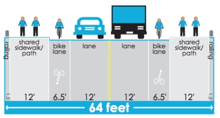
The total project is estimated at just over $300 million. The project itself has just moved into design phase. See the current cross-section below and stay tuned for more coverage of how bikes figure into the plans…
— Read our past coverage of The Sellwood Bridge Project.



Thanks for reading.
BikePortland has served this community with independent community journalism since 2005. We rely on subscriptions from readers like you to survive. Your financial support is vital in keeping this valuable resource alive and well.
Please subscribe today to strengthen and expand our work.
Yikes, no barrier between car and bike traffic? I will be riding the sidewalk, yielding to pedestrians.
The sketch is part of the preliminary design. The on-road bike lane was conceived as a way for faster, more confident cyclists to avoid conflicts with slower bikes, runners and walkers. In the final design process, concepts like a raised bike lane (like Reed Market Road in Bend), colored bike lane paving, etc will be reviewed. Also, the “sidewalks” are multi-use paths that can be used by people on bikes who aren’t comfortable using the on-road bike lane.
Are the local residents aware of that? With a bike lane next to a “sidewalk”, many pedestrians are going to assume that means bikes are supposed to be in the bike lane.
I think so…I’ve been on the Citizens Advisory Committee and it’s predecessor Community Task Force, and it’s been pretty clearly stated that the “sidewalks” as multi-use paths. Maybe something better than currently on Hawthorne Bridge, but along those lines.
What sidewalk?
I’m curious how wide the Sellwood Bridge is currently. Seeing more width devoted to non motorized traffic in the above sketch is encouraging.
from the PDF that Greg linked below it’s 30.9 feet… 1’5″ railing, 12′ lane, 12′ lane, 4’3″, 1’1″ rail…
I would guess the bridge is currently less than 35′ wide — 12′ traffic lanes, 4′ sidewalks, 2′ railings.
Also, remember there’s only 1 sidewalk. And that as far as functionality goes, it is regularly interrupted with bases of light poles. At those points, it’s barely wide enough for one person to walk by.
The current plan basically makes no changes to the vehicle lanes, but vastly increases the space available to non-motorized transportation.
Are there any bridge designs where non-motorized traffic is below the motorized traffic, as in on a different level/suspended beneath the road surface? It seems like that would be much cheaper/less clunky. I lived in a town in Germany where the equivalent of our streetcar lines were suspended from a single rail above the streets and the river that ran through the city. Very space efficient, and has been running since the late 19th Century. Wuppertal Schwebebahn if you want to google it.
9watts: The below-grade option for non-motorized traffic was proposed and rejected by the community. I think a lot of people feel less safe when they’re not visible, and there’s the question of folks living under the bridge, etc.
Also, there is a minimum clearance requirement (I don’t know what it is) since the Willamette is a navigable waterway.
This pdf includes the other half of the above picture – http://www.sellwoodbridge.org/img/PreferredAlt2009.pdf
If you zoom in, you can see the current bridge, as well as the 1st half of construction.
good news. Was there any mention at the meeting about how many people supported the bridge. It sounds like the tea party was just some warm passing air trying to create a stink over nothing.
Also, I think cars and bikes would like to be on diferent levels. Put the bike lane at the raised level with the sidewalk. A big curb is a pretty good barrier.
The consulation is that Clackamas County is paying something, not their share by a long shot. Portland & Multnomah County + auto fees is roughly $250 mllion, their paying $22million. Remember that Clackamas County accounts for 70% of the Sellwoods Bridge traffic. They should pay more if you ask me. The bridge is just one mile from the Clackamas County Line.
Clackamas County got off easy. I was at the meeting last night.
There’s no requirement for Clackamas County to pay – it’s not their bridge. The fact that they are voluntarily paying is a great thing, and we should be thankful for it. Also, Clackamas County does not account for 70% of the traffic. 70% of the trips start or end there. There is a difference – lots of people from Washington and Multnomah Counties work or shop in Clackamas, and a significant number of those trips are made by those people. (for example, someone who lives in Taylor’s Ferry and shops at Sellwood New Seasons – 2 trips which start or end in Clackamas, yet both made by a Multnomah resident)
I have no problem asking Clackamas to contribute, and I fully believe that half the trips are made by Clackamas residents, but lets read the numbers for what they are.
I also would like to have seen a bigger share come from ClackCo, but that’s water under the bridge. It’s good to see that sanity prevailed.
Raised or divided bike lanes make a lot of sense to me, too. My first thought upon seeing the design drawing above was that I’d be riding with the pedestrians.
I live in Clackamas County and was em bare assed for the opposition of a paltry $5 a year. I am very glad it passed unanimously.
They are getting off CHEAP. I just got my registration for my Subaru Outback…which by the way blasted through all of PDX’s flooded streets with ease!
how much money do they expect to make from a $5 fee? It seems like it would just be a drop in the bucket. Administering it alone is going to cost a chunk of money, that sort of wipes out the profit margine
it’s a vehicle registration fee increase. It’ll be administered by DMV and the fiscal overhead will be non-existent since the infrastructure and procedures are already in place. DMV already collects a fee for Multnomah County registrations:
http://www.oregon.gov/ODOT/DMV/fees/vehicle.shtml#Regular_Vehicle_Registration__not_including_plate_fee_
Also, it’s a $5 *increase* – the total fee will be $10. Clackamas County has roughly 325,000 registered vehicles (more than the number of registered drivers), which means an additional $1.5 million per year in revenues. At that rate, the $22 million they’re talking about will take 14 years to raise. I presume that means the bridge costs are being amortized over 15 years.
Thanks Matt-
14 yrs dosen’t sound too bad
I’m assuming the fee will just be tacked onto the auto registration fees for all Mult Co. residences. It should be pretty easy to institute and administer. Everything needed to do so is already in place.
just out of curiousity, why the uproar over having bike lanes the same level, and unprotected from autolanes? There are hundreds of miles throughout the city with this same type of set up. Is it due to lack of an escape route for the bike lane? I can think of many other places in PDX where this type of set up, with an even narrower bike lane (6.5 feet is HUGE) is used next to traffic.
Then again, I’m comfortable with riding the car lane over the Sellwood now. But I am curious what the problem is?
Exactly. The bike lane going south along Willamette blvd. doesn’t leave you any room in case of emergency, as just one example.
Ride in the street if that’s your style, or go slow and use the sidewalk if you feel in danger. It looks like the new bridge will have room for that.
The bridge team worked with a “bicycle and pedestrian working group” including representatives of BTA, Willamette Ped. Coalition, Alta Planning, PBOT, etc. One theme of their work was that the new bridge is a blank slate, and they were seeking solutions that could provide the best opportunities for walking and biking, now and in the future. The raised bike lane makes it more difficult for motor vehicles to sway into them, makes bikes more visible by raising them 4-6″ higher than they’d otherwise be, and give some added protection compared to an at-grade, on-road lane.
The prospect of providing comparable structural support for bikes and pedestrians on this bridge that would be suited to supporting 18-wheelers is–or strikes me as–crazy. I understand that putting non-motorized vehicles on a separate level was already discarded, but will still register my distress at this. It would be so easy/cheap/fun to, for instance, run some 10′ diameter clear tubes above (or below, or off to the side of) the roadway, one for each human powered mode in each direction. This would surely cost a fraction of the engineering and materials to build the bridge as shown in that cross section we saw earlier. Where is creativity? innovation? cost savings? Who’s projecting the material costs for building different alternatives 5 or however many years out the bridge is likely to actually be built?
I’m less concerned that there won’t be adequate space for human powered modes on the new bridge, than that we’re likely to sink so much energy and material not to mention money we don’t have into a structure that will end up being so overbuilt/that doesn’t take into account the changing realities of transport over the life of this (or any new) bridge. Do planners really think we’re going to be relying on 18-wheelers 20 or 50 years out? What are these vehicles going to run on?
The bike lanes as drawn seem perfectly fine to me. Another option would be to leave the existing bridge in place and convert it to a bike/peds bridge, except for maintenance cost that would be a fun alternative.
The existing bridge wouldn’t be a good alternative. The bridge is pulling apart at the westside expansion joint, and there is already a significant gap. (go check it out if you want to experience nervousness about standing on the bridge) in a few more years, that gap will provide a significant hazard to bikes.
Side note: for other scary gaps, check out the pedestrian stairwells at the west end of the Steel bridge, the east end of the Morrison bridge, etc. The MLK viaduct was really scary before the rebuild. These structures are still physically sound, but when you stand on it and see both sides apparently only held together by a couple pieces of rusty rebar, it doesn’t inspire confidence, regardless of the actual physical condition.
that bridge will most likely be the first one to fall when we have the big one