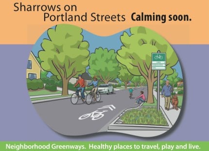
The City of Portland Bureau of Transportation is embarking on year two of a four-year strategy that will blanket the city with 60 miles of new bicycle boulevard streets. From Spokane Street in the deep southeast Portland, to neighborhoods in north and outer east Portland, bike boulevards are popping up everywhere. Recently re-named “neighborhood greenways” to reflect their non-bike and stormwater retention attributes, the streets are easily identified thanks to over 2,000 sharrows that are in the process of being placed on them.
“Portland is creating a citywide network of safe, traffic calmed streets where people on foot, on bike and at play are given priority…”
— From a postcard being mailed to Portland residents
PBOT has held numerous public meetings for each individual project, but they’ve yet to do a coordinated branding effort for their overall strategy. Explaining new signage (like the sharrows) and creating awareness of new bikeways is just as important as the infrastructure itself. On that note, PBOT is about to launch a marketing campaign for sharrows and the ‘neighborhood greenways’ concept.
In addition to explaining what the streets are all about, PBOT has to undo some horrible PR damage (does “sewer money for bike lanes” ring a bell?) that still exists after the communications debacle around Mayor Adams’ $20 million PBOT/Bureau of Environmental Services ‘Green Streets’ funding plan.
In the coming weeks, PBOT will hold a series of ribbon-cutting events on recently completed bike boulevard projects. With community leaders — and hopefully TV cameras — by their side, the goal will be to explain the benefits of how these green, rainwater-catching streets improve the safety of our neighborhoods and save the City money on stormwater management.
I recently got a look at a postcard that PBOT will mail out to thousands of Portlanders in an attempt to educate them about sharrow markings and introduce the neighborhood greenway concept. The front of the postcard is above, and the back goes into more detail about the sharrow markings. Here’s the back side:
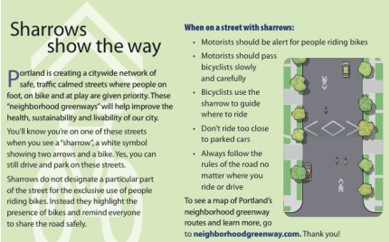
The text reads:
“Portland is creating a citywide network of safe, traffic calmed streets where people on foot, on bike and at play are given priority. These “neighborhood greenways” will help improve the health, sustainability and livability of our city.
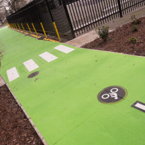
You’ll know you’re on one of these streets when you see a “sharrow”, a white symbol showing two arrows and a bike. Yes, you can still drive and park on these streets.
Sharrows do not designate a particular part of the street for the exclusive use of people riding bikes. Instead they highlight the presence of bikes and remind everyone to share the road safely.”
You’ll also notice that they’re working on a new website, NeighborhoodGreenway.com, that will organize all the information from each project into one place.
Stay tuned for more details, dates, and information on ribbon-cutting events as well as updates on the BES/PBOT partnership and the many bike boulevard projects going on around town.


Thanks for reading.
BikePortland has served this community with independent community journalism since 2005. We rely on subscriptions from readers like you to survive. Your financial support is vital in keeping this valuable resource alive and well.
Please subscribe today to strengthen and expand our work.
I’m pleased that these sharrows are being applied on a respectable network of roads. What would be even better is if they were also added to appropriate arterials to send a clear message there as well. The 11th/12th couplet comes to mind as does sections of MLK.
I biked the N. Concord one last night. It was soooooo nice! What a difference compared to riding on Interstate where the bike lanes magically disappear and then reappear.
Zaphod,
we’ll get there. All in due course. The end of cheap oil will do wonders for bike access to all infrastructure 🙂
I think this campaign is a promising direction and hope we can roll out something like what David Engwicht proposes as the next step:
Reclaiming Our Cities & Towns:
Better Living with Less Traffic
by David Engwicht
“… Cities and towns are eco-systems created by people for their mutual benefit. As Engwicht points out in this well-argued and nicely illustrated book, urban eco-systems facilitate exchange of culture, goods, friendship and knowledge. They provide opportunities for interaction and exchange within a limited space, minimizing the need for travel. Although some travel is needed within cities and towns to facilitate mutual exchange, the cancerous expansion of roads and automobile traffic is ruining our cities and destroying our neighborhoods.
Engwicht became a social activist when he learned of plans to widen an arterial road near his home in suburban Brisbane, Australia. After attending a public meeting to discuss the issue, he became an organizer for Citizens Against Route 20. That group focused on traffic calming, minimizing auto traffic in urban communities to enhance the quality of life, the main subject of this book.
The industrial revolution transformed cities into adjuncts of factory production; viewing cities as machines for production, however, dehumanizes their inhabitants. Writing in the tradition of Jane Jacobs and Lewis Mumford, Engwicht maintains that a different vision of the city is needed — one that embraces diversity, even chaos, and sees the city as an eco-system with its own internal life, creative energy and interdependence. Western cities, he says, have become monocultural with their income-graded suburbs and segregation of seniors in retirement communities. In the U.S., urban neighborhoods and suburbs are also often segregated by race. By reducing contact and interaction with those different from ourselves, such segregation impoverishes us all.”
the full review can be read here:
http://library.nothingness.org/articles/SA/en/display/286
I know I always bring this up, but where in heck did the massive overhaul of Clinton street scheduled for last year disappear to?
plus one to zaphod comment 1 and hart comment 4. in connection with the clinton project, they developed a large scale street marking they were calling a “bike swarm” which would have been a much more appropriate wayfinding treatment for bike boulevards than the sharrow, which is intended to be used on more heavily trafficked streets as a lateral lane positioning market.
http://taking-the-lane.blogspot.com/2010/06/sharrows-as-wayfinders.html
or marker
Hopefully this effort will educate motorists as to what it means when they are on a street marked up with sharrows. I was panting my way up the hill on Spokane yesterday after coming off the Springwater when a church van passed me within a foot. I looked over in alarm at the driver and she yelled, “get off the road!” And sped up. The funny thing; as she was yelling at me, she was driving over one of the new sharrows.
In addition to these postcards, I think the city needs to improve signage – especially on busy streets without bike lanes (and therefore, no bike signs). There could be signs every few blocks with arrows pointing the riders in the direction of the nearest bike boulevard or whatever they want to call them.
I live on Tacoma Street and am constantly amazed by the number of bikers riding past (with drivers either behind them and pissed off, or passing them dangerously close). I wonder if they are riding on Tacoma because they simply aren’t aware of the fact that a bike boulevard is ONE street away and runs parallel to the crazy street that they are currently risking their lives on, or if they’re doing it to make the point that bikes belong (which is a point I wholeheartedly endorse and advocate, but not where it’s going to get me killed; have you seen the way some people drive? They get behind the wheel and transform into some cross between Ricky Bobby and a viking in the midst of plundering a village!)
I really dislike the placement of these sharrows, even though I do like them overall for route-finding and awareness. They are placed further out from the curb than I would expect — sometimes, the ones going in opposite directions nearly overlap. Instead of being in the right wheel track (where sharrows are normally placed, and where it’s generally safe to ride), they are well outside it.
I also don’t like the message on the card that it’s sharrows that mean that people driving should be alert for people riding and should pass carefully. That’s always true, wherever you are!
thank you, alexis.
footnote: at one of the public forums on the klickitat bike boulevard rollout, a citizen asked, will this mean that bikes will be forbidden on fremont (seeking the answer “yes”).
as PBoT creates more and more separated infrastructure without addressing the mandatory sidepath problem, we can expect to be relegated more and more to sidepaths.
re comment 7, while obviously i cannot speak to why someone might choose tacoma over spokane, we need to resist allowing motorists to force the choice. i will often choose alberta over going or hawthorne over salmon or lincoln, or even occasionally division over clinton, and i need motorists to respect that choice. those streets, not the nearby bike boulevards, are where sharrows are needed.
We are loving riding Going with all the stop signs turned. I like the sharrow placement as it clearly tells vehicles to expect riders in the center of the lane. A friend of ours visiting from out of town ended up driving on Ankeny and said he turned off quickly as he wasn’t sure if he should be driving there with all the markings. Perfect reaction!
sharrows on the Sellwood Bridge Deck, please!!!
and, yeah, whatever happened to the art-based Clinton project?
Going St is a leg of my commute from Vancouver/Williams to NE 40th and it is a pleasure to ride with the flipped stop signs and the new MLK crossing.
I’m wondering however if the cycle-track jog at 33rd will also include new pavement on Going between 33rd and 34th…that segment is garbage!! Granted, Going isn’t the smoothest ride to begin with, but that one block is littered with potholes and gravel…no streetlights at night can make that one sketchy stretch.
Sharrows make the rider feel more comfortable perhaps, but they are the wrong remedy for the failure of driver education.
I ride on Tacoma frequently taking the lane where appropriate. My intentions are well signaled and I have not had any close calls in all these years of doing so. I am actually providing driver education by doing this.
A sign in either direction about bicyclists on the Sellwood bridge roadway is routinely ignored by drivers and frightened cyclists. The narrow sidewalk with it’s pedestrians and steep dropoff into a stream of cars is a riskier proposition. Try riding the roadway! It’s not as bad as one may think. Cars will slow and give room when passing. I have been doing this for many years.
Noticed new sharrows put in just yesterday while I was riding home on Center! Glad to see them extending further SE after watching them pop up on Salmon and Lincoln a few weeks ago.
Excited to see what traffic calming goes in as a result of the project. The
Proposed Improvements on the Neighborhood Greenway site just notes “Speed Bumps?” between 62nd and 80th. The diagram hasn’t been updated for the two years or so it’s been online.
Center could really use some improved connections across Powell to connect to Woodward via 65th, 69th or 72nd. With Powell under construction, it seems some of the loop detector markings have been acting up (not triggering on random days) and access to the ped-actuated buttons is difficult while curb ramps are being rebuilt.
Section 9C.07 of the MUTCD (which can be downloaded at http://mutcd.fhwa.dot.gov/kno_2009.htm) lists the proper usages of the now recognized “sharrow.” While the markings as employed on the bike boulevards fall within all guidelines, their seemingly odd placement towards the center of the street likely is a result of Guidance 04 (to be painted 11 feet from the face of the curb where there is parallel parking). Neither this section nor the one for a related sign (9B.06) describe the volume or related lane structure of the street specifically. Multiple references to travel lanes and their standard widths (wide enough to accommodate both a bicycle and vehicle) however, suggest to me multiple marked lanes on whatever road is under consideration would be assumed(i.e., not a bike boulevard or neighborhood street). That’s my interpretation, but read it for yourself.
I think the point @are, myself and others are trying to make (again) is that sharrows are not wayfinding marks for bicyclists who don’t want to look at a map – we have and can use other markings and signs for those purposes, though no, the paint won’t be bought by the federal government. Like signs that read “Bikes on Roadway,” “Bicycles May Use Full Lane,” sharrows are there to reinforce what is already written into the law – in locations where drivers need to be reminded of it, not on side streets where bicyclists are already expected.
Re comment #7 (and others) Instead of reacting to their presence in amazement and trying to kick the cyclists who use arterial streets off of them, perhaps it’s time to realize that these are public streets too, a certain segment of the cycling population wants to use them, and they also need to be made safer for cyclists.
In other words, it’s not all just about bike boulevards, folks.
#8 sharrows should not be placed in the right well track. The right well track is too close to the door zone and often the pavement in the wheel track is damaged from busses, other heavy vehicles and studded tires.
The appropriate placement is in the center of the lane.
Sorry, the right link is without the “)” is: http://mutcd.fhwa.dot.gov/kno_2009.htm
I think option 01 of 9B.06 is telling for the purposes of these markings – places where widening or general restriping of roads would prove to be impossible, but there is still a desire/need for bike infrastructure. Again, just my interpretation.
When I read through this brochure, I’m left with the impression that Portland is beginning to use the Sharrow as a “bike route designation” rather than as a traffic marker.
I would think this may lead to confusion amongst motorists w/r to the purpose of the sharrow, possibly leading to a mis-educated belief that cyclists are only permitted on those streets ‘designated’ with a sharrow symbol.
So is the Clinton Street project just dead now? There were going to be multiple functional artwork installations, additional signage, curb extensions at 26th, multiple bike corrals, I have a hard time believing all the time and work spent designing all this is simply being thrown away…
Other streets that need sharrows a lot more than the bike boulevards do:
E 28th, SE Stark to NE Broadway.
SE Hawthorne, SE 12th to SE 39th.
SE Stark, entire length.
SE Milwaukie, SE Powell south to city limits.
I’m sure this list could be expanded on by someone more familiar with NE PDX than I am.
Sharrows on 4th are also badly needed. Its ridiculous that we have a bike lane/cycle track going only ONE DIRECTION downtown.
sorry to sound a bit snarky, but i am still rather confused about painting some arrows in the middle of the street qualifies as infrastructure. it’s not infrastructure, it’s paint. paint will not in anyway prevent you from getting hit by a car. buffered bike lanes, separated cycle tracks, and perhaps (heaven forbid) actually closing off streets to automobiles completely would make riding a bike safer and more accessible. frankly i think sharrows are a complete waste of money, which would better be spent doing something that actually matters.
In the downtown core I’m actually opposed to either sharrows, bike lanes or cycle tracks on the major north-south streets. These are mostly three lane streets and the safest place to ride to avoid doorings and hooks is actually in the center lane. Signals are already timed for 15 mph, that’s all the traffic calming necessary.
what about sharrows on SE 11th and 12th to powell?
This is the easiest and fastest way to get from north to south in inner south east, and yet on several occasions i’ve been called a “F__KING IDIOT” and been buzzed when riding in the right lane, because apparently changing lanes to pass is difficult.
Why is our mayor not riding his bike?
agree w/ burr comment 24, though usually i ride in the left lane and my perception is that the lights are times to 12 mph. sharrows would only confuse the situation.
my concern is that by identifying the sharrow with side streets and “calming,” PBoT is (intentionally?) diluting their effectiveness for their intended purpose.
an alternative reading (hey, red five, are you paying attention?) is that PBoT is laying the groundwork for putting sharrows where they actually belong, by which time they will have acquired the secondary meaning this p.r. campaign describes, and motorists will get the message that cyclists are the preferred user of every street.
Anybody?
http://www.portlandonline.com/transportation/index.cfm?c=egdhb
Hart, I went to that open house on the Clinton Street project back in May 2008, and at that time they were saying it would be completed in Fall 2008. So it’s now almost 2 years behind schedule. I’ve made some inquiries about it status, with no definitive answer, but no one has said the project has been canceled altogether.
an alternative reading (hey, red five, are you paying attention?) is that PBoT is laying the groundwork for putting sharrows where they actually belong, by which time they will have acquired the secondary meaning this p.r. campaign describes, and motorists will get the message that cyclists are the preferred user of every street.
it would be great if this was true
Burr & are, agreed. Bikes belong on any and all streets, not to be relegated as a “secondary” user.
“Sharrows do not designate a particular part of the street for the exclusive use of people riding bikes. Instead they highlight the presence of bikes and remind everyone to share the road safely.”
-safely and *equally* would be the appropriate language.
BTW, sharrows can be looked at as being interim consciousness raisers, being just paint and not concrete infrastructure. Someday they will simply not be needed. But for now, they help drivers get it, their roadway sovereignity is not valid.
I don’t know if this is the Clinton project in question, but they’re doing a lot of construction on Clinton right now. I’ve changed my route to Lincoln for the short term while they repave and add those water-catching curb extension thingamabobs.
-Scott E
Hart (#5) – No, that’s a really good question. I was on the advisory committee for that project, and I’d also like to know what happened to it, and when we can expect it to be implemented. Also, has the city gotten counts of current traffic for comparison later after Clinton is completed, and later still during and after the Division St. work that is scheduled?
Ben (#7) – Some of them are riding to destinations on Tacoma. If you are going to New Seasons, and riding over the Sellwood Bridge for example, it’s easier to stay on Tacoma than to get off for a few blocks and come back. EB on Tacoma is downhill most of the way and fairly easy for bikes to travel at the posted limit in many spots.
Alexis (#8) – Federal guidelines for the draft MUTCD stipulate that on streets that allow on-street parking, the center of the sharrow must be at least 11′ from the curb:
http://members.cox.net/ncutcdbtc/sls/slm-draftpart9.pdf
If no on-street parking is allowed, then the sharrows can be in the right wheel track. So the city is basically following the proposed federal standard.
Agreed 100% about the message on the card.
BURR (#21) – What’s the speed limit on those roads? I agree, but any roads/stretches of roads with speed limits in excess of 35mph cannot have sharrows.
bob k (#23) – It’s still infrastructure, it’s paved. What it’s not is “enforced exclusive” or “physically separated” – but still infrastructure.
Red Five (#26) – That’s a good question. He needs to get places quickly during the day, but he could have the car at the office for that and commute via bike (or Tri-Met) to and from the office. I’d argue that’s the hallmark of a good mayor. It’s hard to represent the people if you don’t understand what challenges they deal with.
Scott E (#32) – That might be, but it’s been a long time since I’ve heard anything from the city about it, and if they are working on it, it would have been nice if they’d emailed the advisory committee that provided input during the process that the project was actually being built.
Follow-up is an action item that the city, state, and especially the COUNTY needs to work on. Some guidelines as to what follow-up is REQUIRED and what is nice but optional would be a good start.
Burr, I agree that taking the lane is the correct way to negotiate downtown. Nevertheless, may drivers do not understand this and a high percentage of cyclists are intimidated by high volumes of traffic. IMO, sharrows in the center of lanes (a la Market in SF) would be a great improvement. Also, sharrows do not prevent vehicular cyclists from taking other lanes.
And frankly, I am not a fan of the cycle track. It makes turning left dangerous, IMO.
re comment 33, none of the streets burr mentions have posted limits over 35.
Some etymology on “sharrow”– it’s a newly coined word, a condensing of “shared roadway” and “arrow”–this courtesy of wikipedia. Invented by a bicycle transportation planner with the city of San Francisco.
I like the new markings – their size makes it easier for all road users to see and be aware of cyclists. However, for someone new to route finding, there is no indication of turns, other then not seeing a sharrow in the next block. The old small white circle markings did have route turns marked, but they were hard to see. Some routes are supported by direction signs, but not all.
Scott E (32) – the current project on Clinton is a resurfacing along with some improvements to storm drainage installed. Rumor is there may be some speed humps between 39th and 50th. Apparently, it’s part of a stimulus grant the City got for street maintenance.
Based on comments from the construction contractor, the art-based project that Matt Picio, I and others have mentioned does not appear to be included as part of the current construction.
I’m inclined to share some of the concerns expressed by # 23.
Last weekend I led a group bike ride through SE Portland, over mostly residential streets. Some were marked with Sharrows, most were not. I did not notice any change in the behavior of car drivers on marked or unmarked streets.
Perhaps education and time will change this but I remain dubious. I’m one of the freaks who is waiting for Peak Oil, because I doubt anything else will really compel folks to change their driving habits significantly.
Further, in response to those wondering about putting Sharrows on Hawthorne and MLK — seriously? Why would you insist on putting these “share-the-road” markings on busy and/or narrow streets with high motorized traffic and virtually nowhere for bicyclists to go but in the middle of the lane? Such an action would render these markings truly impotent.
The City definitely needs to pursue more aggressive outreach for these projects. Outside of a small group, “sharrow” is a nonsense word and people don’t know what the symbol that they’ve never seen before is supposed to be telling them as a pavement marking.
Sharrows went in on 80th a few days ago. My father-in-law thought they were to warn motorcyclists about speed bumps, since there are a lot of people in the neighborhood who like to ride crotch-rockets back and forth on 80th between Powell and Holgate at 40 mph, speed bumps be damned. He didn’t know that the stencil was showing a bike. Without the context and background knowledge that the audience on this site takes for granted, his conclusion is perfectly logical and understandable.
PBOT should get this on the news, and tell their side of the story first, before some lazy KATU reporter brings a lawnchair out to a new neighborhood greenway and starts interviewing confused residents without bothering to contact the city. These postcards should have went out last month.
re comment 39, it is precisely because proper lane positioning on hawthorne or MLK is in the center of the lane that sharrows are needed, both to urge cyclists to move left and to alert motorists to expect cyclists in the center of the lane.
Interesting that their demonstration pamphlet includes bicycle-unfriendly infrastructure such as speed bumps and tables, rather than chokes and cushions. It’s as if nobody at PBOT has a brain.
I’d rather see the sharrow money going toward cutting back the blackberry vines on uphill Capitol between Barbur and Wilson High School. (Link to google street view from when the vines were smaller here. Or by 18th and Beaverton-Hillsdale (google street view link here.
Re 41: that is just idiotic. Cars and bikes have to coexist for the foreseeable future, and given the weight ratio (among other things) it is foolish to encourage any cyclists on major throughways like MLK, 39th, Tacoma, etc when there are very nearby, calmer, and safe alternatives.
This is not second class citizenship, this is smart transportation management. We also discourage pedestrians from crossing willy hilly, don’t let cars drive on rail beds, don’t let people canoe in major shipping lanes.
#44: Really? So that’s why pedestrians roam freely in traffic lanes on Vera Katz Esplenade, Willamette Greenway, Springwater Corridor and the Westside Regional Cycleway, huh? And nonmotorized watercraft do have equal access to the channel on the region’s rivers; in fact, sailboards and sailboats have the right of way over craft that aren’t wind-dependent.
Yea, horizonal traffic calming is preferable to speed bumps and the like. I also find markings without design changes to be ineffective – drivers respond to clear zones, lane/road widths and building setbacks way more than signs and markings.