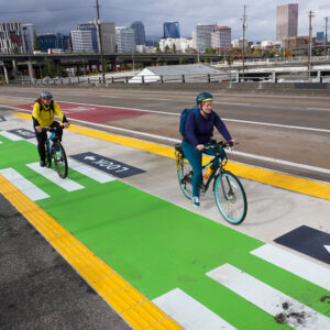
After more than 12 years of planning and advocacy a new non-motorized pathway opened on the Morrison Bridge today. The 15-foot wide, $1.9 million facility on the south side of the bridge is expected to become a popular route for bike traffic and take pressure off the overcrowded and nearby Hawthorne Bridge.
At the dedication ceremony today, soon-to-be Chair of Multnomah County (they own and manage the bridge), Jeff Cogen, said the 7,000 bike trips per day on the Hawthorne Bridge “Shows how much Portlanders love bicycles,” and that it also shows, “we need to increase that access, because frankly, it’s too crowded over there.”
Cogen also announced that the new biking and walking path is officially dedicated to Gary Tipton and Lynda Pilger. Tipton was riding his bike across the bridge on the evening of July 31st 1997 when he was hit and killed by a drunk driver (who was later sentenced to five years in prison). Pilger was walking with her dog in May of 2004 when she was hit and killed by a man who lost control of his car on the bridge’s steel deck (the driver paid only fines and was cited for careless driving and improper lane change).
The new, safer path Cogen said, is a fitting memorial and is meant to, “Correct what was not right in the past.” Family and friends of both Tipton and Pilger were at the event yesterday and a plaque has been installed on the bridge.
When the five-foot sidewalks on the Morrison Bridge were built back in the 1950s, Cogen pointed out, “cars where king in this country.” Now the pathway is 15-feet wide, but it also must handle two-way biking and walking traffic in a city that has seen bike usage go up 180% since 2000.
Is it up to the task? Judging from what I heard and saw today, the design leaves much to be desired.
On my first ride up from Naito Blvd. to try out the new bikeway I came across a man on his bike headed toward downtown. How do you like the new path? I asked. “I want to keep going straight! Why can’t I go straight!?” he said. The man was annoyed that westbound bike traffic is directed back down the cloverleaf ramp to Naito instead of continuing into downtown. Despite two new “No Bikes” signs, the man said, “Well, I’m going straight anyways,” and rode down SW Alder — against oncoming traffic — into downtown.
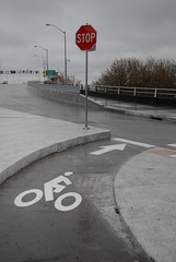
Another issue with the west side of the bridge is how eastbound bike traffic approaches the bridge from SW Alder. Bike traffic is directed from a bike lane on Alder onto the bridge deck via a median. There’s a stop sign for bikes at the intersection where the cloverleaf onramp from Naito comes up. I was surprised that motorized traffic coming up the ramp does not have a stop sign.
In a similar situation on Hawthorne Bridge, motorized traffic coming onto the bridge from Naito has a stop sign and bike traffic does not.
If people on bikes do not heed this stop sign (and none did while I watched for several minutes yesterday), they will ride right into fast-moving motor vehicle traffic. Making matters worse, visibility between the bike lane on Alder and the motorized vehicle lane from Naito is severely impaired due to a metal guardrail (seen at left of photo above).
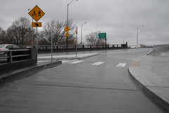
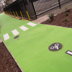
As I continued on the bridge headed east, I enjoyed the smooth and wide path. I was alone, but couldn’t help but think how it’d feel on a warm sunny day with tourists, joggers, walkers, and bike traffic zooming by me. Except for a short segment in the middle of the bridge span where a curb separates a sidewalk from the bikeway, there are no pavement markings (like on the Hawthorne) to clearly delineate the biking space from the walking space. (The County says they plan to add markings in the future.)
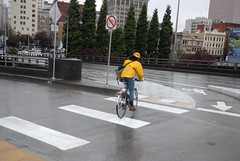
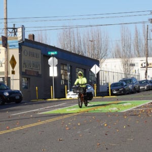
Coming downhill on the new path to the east side, the path dumps riders out onto SE Water Ave. and it’s not clear how to transition onto the street. As I stood taking photographs, I ran into two other people on bikes who were just as confused as I was.
One of them, former transportation planner Daniel Lerch, was so concerned that the fired off an email to the County, Mayor Adams’ office, and Metro detailing several design issues he says, “pose serious safety hazards to novice and less-than-fully-alert cyclists.”
In his email, Lerch writes,
“There are numerous wayfinding signage and marking problems that, while not necessarily safety issues, are not what one would expect on an officially-opened transportation facility…
I urge you both to look into these safety hazards and rectify them as soon as possible. It is no small irony that a bike/ped path dedicated to two people sadly killed in crossing the pre-path bridge has actually *created* some new hazards that may be potentially life-threatening.”

Bridge bike access is on the left, but
it’s not clear how to get onto it.
For westbound bike traffic coming from SE Water Ave onto the bridge, it’s not at all clear how to get onto the new bikeway. Sitting at the intersection of Yamhill and Water, just across the street from where the new onramp is, it’s hard to tell how exactly to get onto the bridge. A bike left-turn symbol is supposed to be in the center of the lane but it’s been covered over by a pothole repair. But even if it was there, people on bikes would have to merge across traffic into it with no other signage showing them the way or warning car traffic about their presence (which means 95% of Portlanders won’t do it).
The Bicycle Transportation Alliance has also shared some mixed feelings about the new path. They’re concerned about “relatively steep grades” that may lead to “conflicts at intersections.” They also feel that “bike/ped zones need better marking” and that “wayfinding at either end of the bridge is seriously lacking.”
As one veteran bike advocate told me at the event (but requested to remain anonymous so as not to rain on the parade), the mid-span of the bridge is great, but there is a lot of room for improvement at both ends. “Is it ideal? No. But it’s an improvement, and I’ll take improvement over nothing any day.”
— See the photo gallery for more images of the bridge and the dedication event. More coverage from KGW-TV.



Thanks for reading.
BikePortland has served this community with independent community journalism since 2005. We rely on subscriptions from readers like you to survive. Your financial support is vital in keeping this valuable resource alive and well.
Please subscribe today to strengthen and expand our work.
A lot of times it seems like these things are lack coordination and communication.
The bridge portion itself is well done but the non-bridge portions that interface with the surface streets were left essentially unplanned as if they were some one else’s problem. Bridge designers design a mighty fine bridge but once you’re on land you’re on your own.
Should PBOT or some other agency been involved/consulted on how this bike traffic diverted from Hawthorne will dump out in to auto traffic?
the city was made aware of problems with the design at the east and west ends of the facility many times during the development process and chose to ignore the critics, to their own detriment today. Now that it’s ‘cast in concrete’, further changes to the design beneficial to cyclists will be difficult if not impossible to make.
The failure to connect the westbound path to the downtown street grid at SW 2nd and the failure to connect the eastbound path to the eastside street grid at SE Grand are both major deficiencies that should have been addressed in the initial design.
q’Tzal – PBOT had a major role in the design of this facility, so don’t solely blame the county for the deficiencies.
Anybody else notice they got the word order wrong? When you ride over it, it says “PEDS TO YIELD.” Oops!
Also, whatever happened to “turning stop signs” so they face motorists? They can get up to speed better.
Clearly more guidance signs directing the way into downtown are needed, and instead of a NO BICYCLES sign, something a bit more accurate, like “DO NOT ENTER” and “WRONG WAY” to reinforce the message they’re trying to say.
It should be easy enough to get that additional stop sign installed for the ramp.
Those no bike signs were definitely not what I was expecting after seeing these plans over a year back:
http://www2.co.multnomah.or.us/Departments/Community_Services/LUT/bridges/morrison_bridge/BikePed%20pdfs/Alder%20Street%20Options.pdf
I think the biggest deficiency in this path is the lack of easy to use, logical, and direct connections to the existing bicycle network. There’s a reason the Hawthorne and the Broadway bridges are the most popular: they have such connections that the Morrison has always and still to this day lacks.
When a cyclist can go both ways from Grand to SW Second and back without having to stop or yield, then I’ll be satisfied and might actually try using it over the Hawthorne for once.
I rode this bridge last Friday for the first time since the Christmas Day ride when we hopped the barrier and checked it out. It feels equally incomplete now as it did then. This bridge will be a failure until an intelligent redesign is done to it.
An I really don’t understand why the ramp on the West side gives priority to cars. It’s not consistent with the Hawthorne, and consistency is the one thing that helps compliance. I wonder how many drivers will forget to stop on the Hawthorne after crossing the Morrison a few times, just as I’m sure many cyclists will ignore the Morrison stop sign because they’re used to how the Hawthorne does it.
I hope there’s room for a few more plaques.
As I was looking at this bridge on Google Maps, I am convinced that the overall design of this path took a wrong turn at every opportunity. Consider the reason for dumping bikes off at Water St. Is this not the same situation as the 99E offramp at Hawthorne? Why couldn’t bikes go straight, and force cars to yield here also? And put a light in at the I-5 offramp? These two, and the case in my previous post, are three cases where the designers could not bring themselves to prioritize bike traffic over auto traffic. Where was the political will?
It’s just amazing that a fully separated bike facility –which should be geared towards cautious and inexperienced riders — is perhaps only appropriate for the most experienced cyclists, because of poor design.
And I won’t hold back my criticisms just because I’m glad they gave us something. We’re beyond that. If they screwed this up, we have to tell them.
plus one to comment two. inadequacies in the design at each end of the bridge has been a subject on these boards many times. i dimly recall only slight opportunity for input at what seemed a late stage — three diagrams from some office, with staff recommendations rejecting two of them. i visited the west landing before the bridge opened and was discouraged by what i saw. have yet to roll the actual bridge, so will try to suspend judgment, but instinct is telling me this will not become a favored route with burnside and steel just a little ways up.
I’m ecstatic to have the facility open, but I agree with many of the justified and articulate criticisms above. The County indicated they were open to refining and tweaking the design. Lets correct these items as soon as possible!
#3 BURR
I can’t blame PBOT because I don’t know their level of involvement. I don’t know who to blame and don’t care for blame other than in its application to preventing the same problem from occuring again.
From the project website we can see that Multnomah county seemed to be in charge.
Somewhere on the page I thought I saw the Metro seal.
Surely this bridge upgrade costed a lot of money: was any of it state or federal?
For someone not involved in the day to day workings of the government I don’t know where the ball was dropped but it did ocurr.
I’m a year round commuter to Downtown from the SE, and so far I strongly prefer this new facility. Just thought I’d pipe up after seeing 100% unhappy comments.
I come down from the Springwater by OMSI and I used to go by the submarine, through some real rough patches under I-5, and then take the cloverleaf up to the Hawthorne Bridge. This last part is an extremely dangerous area for me, as people bomb down the hill (disregarding the pained “slow” symbol), passing me on the right (!!!) or tailing me just after I blindly merge across the pedestrian lane. This is always my least favorite part of the day, followed closely by the never fun merge with buses at the west side of the Hawthorne Bridge.
Now I take Water all the way from Caruthers to the Morrison Bridge via a (very bumpy) bike lane. After a rousing ride up the incline, I heed the signage and take the new cloverleaf down to Naito. A quick right turn and I’m heading into downtown on Morrison St. No more merging with buses, just a few MAX tracks to cross.
On the way home, I take the full bike lane on Stark down to Naito’s bike lane, ride under the Morrison Bridge, and take the new cloverleaf up and over. No more cars sticking their hoods into the bike lane to see around the Mickey Mouse guy.
Oh, and there’s a great view at the top of the bridge – way better than the Hawthorne’s.
In short, it’s perfect for me. Thanks!
I appreciate the improvements, but someone needs to deliver the bitter pill to the decision makers in the process that landed this path: For the price tag, this is unacceptable. Is it really so hard to look at Copenhagen or cities in the Netherlands and get if you want high ridership numbers then make it safer, easier and faster to use a bicycle (or walk for that matter) over driving into the city center? It is absolutely ridiculous that for 1.9 million dollars and in a post-platinum Portland, the facility does not provide intuitive, uninterrupted, and DIRECT access for bicycles and pedestrians into the city center. This would have been an A facility circa 1990, but now, a C- at best.
I generally use the Hawthorne for my morning commute (to downtown) and the Morrison in the evening. I don’t think the Morrison will ever be too crowded because it’s a bit steeper and a bit more inconvenient than the Hawthorne.
I agree that there should be a stop sign for traffic on the ramp at the west end of the bridge, though the idea that we’re too stupid to stop at a stop sign rather than just biking directly into traffic is a bit depressing.
For those of you arguing that the bike lane should have been continued all the way across Morrison, I’ll make the same argument I’ve made every other time it’s been brought up. The I-84/I-5 exit ramp makes this bridge fundamentally different than the Hawthorne, not only are there people trying to get off of the bridge to 99e, there are also people trying to get ON the bridge from I-84/I-5. The amount of room that these two lanes of traffic have to make that maneuver is a bit more than 1 city block… somewhere over 200 feet. Even worse, the traffic coming off of the interstate exit ramp has limited visibility until they’re right at the merge point.
The only way to safely put bike traffic on this bridge would be to close down the highway exit ramp to Morrison. Until that happens, I can’t see the city sending bike traffic all the way across the bridge.
I am happy to have this bridge usable at all, as it is the shortest path between my house and downtown. I used to add a half mile to my trip by taking the Hawthorne or Burnside bridge. The old Morrison bridge sidewalk was the scariest biking experience in Portland.
The new designs central flaw is the same as the Hawthorne and Broadway bridges: it doesn’t segregate bikes and pedestrians. Pedestrians walk two and three abreast, often with dogs, and are completely unpredictable. We need lane markings that make it utterly clear where bikes belong and where peds belong, and I mean with a stripe, not the silly symbols that Hawthorne has.
I just walked over to check this out. I agree with the impressions of the issues on the ends of the bridge state above. I also think once the weather turns nicer there is going to be a lot of bicycle traffic westbound that will continue to 2nd on the pedestrian sidewalk and not take the ridiculous cloverleaf to Naito and then backtrack. This traffic will come into conflict with Eastbound cars on Alder that choose to take the weird alley to 1st instead of going over the bridge. That alley should be blocked off even if cyclists are trained to take the cloverleaf.
This westbound “cloverleaf-only” problem is going to be an issue. I was biking north on 2nd this morning, and saw a fellow cyclist come down the sidewalk at quite a clip, cut across that one-way alley, and turn onto 2nd. That problem is going to repeat itself even more as more folks start using this ramp.
I used the Morrison Bridge path headed East yesterday, and ended up on the pedestrian sidewalk on Alder instead of the bike lane. Traffic moves so fast once that light at 2nd turns green, the bike lane didn’t seem safe…but it also isn’t intuitive or well marked, either.
I attempted to take this route last week to see if it was any faster than the Burnside Bridge. It wasn’t. For one, I got lost, and although that can be remedied for future trips, the biggest problem was that I got stopped by a train. The other two bridges take you over the tracks. If you are in a time crunch, you can never count on not being stopped by a train. (Obviously, the bridge could go up too in response to a boat, but that’s not very frequent.) I am glad that it is there, but I hope that they will extend the path to the eastern most point of the bridge.
Video of Dedication for those of you who were not there and would like to see some of the dedication ceremony…
comment 16: “The only way to safely put bike traffic on this bridge would be to close down the highway exit ramp to Morrison.”
or slow it way down before it hits the bridge (which might require building a longer exit lane on the highway at a cost of $x) or keep the exiting highway traffic in a separate lane, preventing a merge altogether.
but yes, this was one of the major challenges in designing what we now see. here and there, some choices might have been made that were less favorable to motor traffic and more favorable to bike/ped traffic. some still could be.
A friend and I had to access the new path from the Esplanade (via the circular path that goes up to the Morrison Bridge) because we couldn’t figure out how to get to it from Water. We were on foot (I had my bike with me, but was walking along with my bikeless friend). They definitely need to improve the markings, at least on the east side — it’s not at all clear where you need to go, if you don’t already know the area very well.
On the plus side, it was a beautiful day for a walk on the Esplanade, and we (and a whole bunch of others) saw two bald eagles perched atop a tree surveying the scenery.
Perhaps this ‘event’ (the design flaws – split responsibilities and cost) is an opportunity to pick up on a past Sam Adams idea…for the City take over from the County the operation of any arterial Willamette River Bridge.
It seems an odd hold over from old practices – perhaps dating to when separate cities were on each side of the river (Albina and Portland)?
This transformative change would make for a faster and more cost effective transition of these bridges from an auto mobility focus to serving multimodes and as a development tool (and perhaps congestion management tool).
I walked across the bridge at lunch today and thought it looks and functions just fine. On the west side, as is always the case, it requires caution to get onto the bridge and go east. On the east side, the spiral heads down to the esplanade–again, caution and checking speed is probably a good idea.
I also stood where Jonathan took the photo of the guy riding against traffic this morning. Had this rider simply taken the sidewalk down the “clover”-like turn to the waterfront, it might add a few minutes to his commute. No big deal. Everyone would love to ride from door to door in the most direct way possible. Well, it doesn’t always work that way. We ride because we prefer it over driving, which is usually faster. I live in far NE and work in SW. I just might take the Morrison over to hit the esplanade and head north from there–if that means a few more minutes, fine with me. Design flaws notwithstanding, it’s great to see the investment in another safe(r) route over the river.
peejay #8 is exactly right: the inconsistency between this cloverleaf and the Hawthorne one is dangerous. A bicycle is going to get clobbered there before a month has gone by. This is a tragedy waiting to happen.
There needs to be a flashing stop sign for the eastbound cars coming up from Naito. And preferably no stop sign for bikes eastbound on Alder trying to keep momentum up the hill, but at the very least the auto traffic needs a stop sign.
There will need to be pavement markings telling bicyclists which way to ride, and pedestrians which way to walk.
peejay (#9) – Where was the citizen input? Respectfully, the time to put your 2 cents in on the design was Aug-Nov of 2008 when the final design work was being done. The county bike/ped committee heard from both PBOT and MultCo Transportation Dept. as to the design challenges on this bridge, and despite word being put out about the meetings, there were almost no members of the general public at these meetings for comment. It’s easy to cry about political will, design decisions, etc – apparently easier to complain after the fact than to keep abreast of developments and go to the occasional meeting.
I appreciate that you want to tell the county they screwed up, but we really needed the help with concerns back when the final design was presented. Especially at the county level, where any funding is practically a miracle and changes after the fact are non-existant due to lack of a funding source.
peejay – you are right-on regarding the inconsistency with Hawthorne, and I hope the county rectifies that. That’s exactly the kind of thing that’ll get someone killed.
I think the design is fabulous. Keeps speeding cyclists from crashing into me while I enjoy a leisurely stroll through my fair city. Go hog the other bridges you bunch of hipster bicyclists. This bridge is for the slow pokes. Gawd why can’t us walkers have a little peace and quiet atop one of the Portland bridges without god-awful cars and bicyclists mowing us down? I’m gonna have breakfast on top and I’m not gonna share — breakfast on MY bridge, bitches! Thank you Multnomah County for keeping our bridges livable from unruly two and four wheel nazis. Ungrateful bastards.
I was really looking forward to the new bike path on the Morrison bridge and I applaud the city and county for finally opening it up.
But as a commuter by bicycle, I am really disappointed in the approaches at both ends and I think it is a accident waiting to happen. The Alder street approach is bad enough where if you are not a really paying attention, a rider will be going against traffic on a one way street. Not good. Even when you follow the ramp down to Natio Pkwy, you are faced with a dilemma on which way to go. No clear markings unless you are just going south on Naito Parkway.
The Water Ave end is even worse. It terminates at a 4 way stop with one of the auto approaches a ramp off the freeway. The markings give no clue as where to go. This needs better markings and is not a real good design.
After using the new path this week to commute to/from work, I may end up going back to using the Hawthorne bridge path as it is just safer to use, even though much more crowded. Too bad.
in fairness, matt 27, the process of selecting the south alignment and rejecting the idea of dropping a westbound lane, etc. was all done back in 2003
http://www.scribd.com/doc/29252175/Open-House-Handout
http://tinyurl.com/yfhslg5
so okay, yeah, there was an opportunity for public input, but any input offered in the fall of 2008 would have been spitting into the wind.
I suspect that part of the challenge in coming up with a decent re-design is that this bridge connects with high-speed freeway traffic, and there’s no way you can simply “eliminate” a lane here or there in that case. Sorry, kids, but the car is still king on the Morrison Bridge. Based on what I’ve seen I’m glad I don’t have to depend on this bridge for downtown bike-ped access.
I walked across the Morrison bridge path last week and rode across it this morning.
The crash site at Alder Street and the freeway ramp is really quite bad. A big part of the problem on is that, unlike the on-ramp to the Hawthorne bridge, the cloverleaf auto traffic merges directly into its own lane. As a driver, you won’t intuitively slow down there, particularly since drivers are unable to see the oncoming bike/ped traffic at all. Without a stop sign for cars on the ramp or at least a flashing warning light for bikes and cars, there will be injuries. I also wonder what happened to the original Alder Street plan posted by John #6. It was better than the current arrangement.
That said, it is a wonderful path for walking to the Esplanade or to Waterfront Park. My hope is that it diverts some of the pedestrian traffic off of the Hawthorne as well as all of those slow, monstrous, bike paddleboat things.
None of the bridges are perfect crossings for bikes and I guess that a retrofitted freeway bridge was never going to be the best option. It is still an improvement over the old narrow sidewalk.
Didn’t I hear the county recently got rid of its bicycle/pedestrian advisory group again? This is a county facility, regardless of PBOT’s involvement it is only advisory, the county is the decision maker and responsible for making this work.
I think the problem really is that Hawthorne is a local bridge and Morrison is still largely a freeway on-ramp. Bikes and pedestrians are being better tolerated, but not encouraged.
I am excited to give it a try. This article dampened my excitement a bit. Thanks for pointing out the areas of concern this is great info and I’ll be a bit more cautious then I would have been.
This is a county facility, regardless of PBOT’s involvement it is only advisory, the county is the decision maker and responsible for making this work.
That depends. The City put up all the $s to widen the sidewalks on the Hawthorne, and if the City put up big bucks for the Morrison Bridge facility too, they should have had plenty of design oversight.
In the most recent previous article about the bridge, I was critical of how the routes connecting to the bridge were mainly lacking in facilities. I rode it again today, once each way, and decided even those weren’t quite so bad as I first made out. Honestly (and I’m no engineer), I feel like while it was perhaps not the most ideal design, it was a difficult facility to work with at the outset, modified to leave as little major structural changes as possible. I feel like ya’ll are giving it an unwarranted bloody nose and someone should at least play devil’s advocate.
Having to yield to traffic coming up the ramp from Alder is not ideal, but it is necessary to slow down there anyway because of the sharp left up the ramp to hit the bridge eastbound. I really don’t think we’ll see more accidents as a result of this “inconsistency” with the Hawthorne than we would with anywhere else people are willing to blatantly ignore traffic control devices. The “no bikes” sign really should be swapped for “do not enter,” but they are quite visible and anyone who ignores them is doing so willingly, and deserves whatever chastising they should receive as a result.
Water Ave needs to be repaved and repainted in conjunction with this project in order to make it more ridable. The pot holes, exposed manholes and train tracks, ruts and rough pavement are bad in a car, much less on a bike. However, turning left from a bike lane either onto the eastern approach or onto Taylor coming from the bridge is no less or more tricky than crossing a lane of traffic to make a left from a bike lane is anywhere else in the city. It’s really never an easy maneuver. From there you can connect to 7th and find your normal routes from Ankeny to Division into SE without any real issues. Downtown is more or less a mess no matter how you dice it, and taking SW Morrison after descending the cloverleaf to Naito is probably about as good as any other route. At least the crosswalks can give you some modicum of protection to ease your way back into traffic.
It’s a bridge, and almost ALL the bridges combine bike and pedestrian traffic in one form or another, except Burnside. If you want to race, go across there and you can dodge cars. Otherwise, slow the eff down until it’s _safe_ to go fast again. Limited space mean making compromises with it, unless you want to triathlon-ize your commute and swim across the Willy.
I’ll repeat what I said before, though, that the new facility is a welcome way to ease congestion on the Hawthorne, though I generally believe it will take more experienced/less timid cyclists to really make sense of and combine it as an integral part of regular routes into and downtown. Maybe those of us who are in that position should do so, and help leave “easier to use” facilities for the newbies.
People say that you can’t take the bike lane all the way to MLK/Grand because you can’t interfere with the I5 exit. I call shenanigans on that! The cars have already exited I5, and are headed on what will become Belmont St, fer chrissakes! They’re going to have to slow down — even stop at a light — eventually; why not before they enter the bridge?
Like I said earlier. People made their priorities, and we have to live with them.
BTW, Matt, I would have loved to go to meetings and say my piece. I often do about other issues (CRC, for example). I guess I screwed up by assuming that professionals were in charge of this project and it would be done competently. My bad.
People say that you can’t take the bike lane all the way to MLK/Grand because you can’t interfere with the I5 exit. I call shenanigans on that!
Exactly! If you’re driving on the freeway and exit onto the Morrison viaduct, you are no longer on the limited access freeway, you are on a local street, where it is completely legal to bicycle.
If this ass-backwards logic had been applied to the Hawthorne, they would have made eastbound cyclists exit onto Water Ave. there to, instead of building a facility that allowed cyclists to use the viaduct and cross the exit ramp for SE MLK/McLoughlin Blvd.
peejay #38 and BURR #39:
I never said you can’t interfere with the interstate exit, I said you couldn’t build a bike lane there safely without removing the exit.
As previously mentioned, the Hawthorne and the Morrison aren’t comparable. On the Hawthorne auto traffic has great visibility of cyclists as they cross the 99e exit ramp, and cyclists only have to keep an eye on one lane of traffic exiting onto 99e.
On the Morrison the interstate exit ramp has really poor visibility of the traffic in the adjacent lane until it’s basically at the merge point. Cyclists in the right lane prior to the merge would have to contend with traffic trying to merge from the right lane to the the middle lane (to stay on the bridge) and the middle lane to the right lane (to exit onto 99e). All of this happens in 200-300 feet.
Sure, a bicyclist can legally ride through this space, but it’s *incredibly* dangerous and short of closing that exit ramp I don’t see how the city/county can mitigate that danger. Considering the fact that a lot of people here are complaining about the danger of the stop sign crossing on the west end of the bridge, I suspect most cyclists would agree.
What would you guys propose to do to make this section of the bridge safe for a bike lane? How would you mitigate the above-stated dangers?
A good start would be large clear signage prior to the merge zones indicating the presence of cyclists and the requirement to slow down and yield to cyclists, and a well marked colored bike lane in the merge zones, just like the city has done on the Hawthorne viaduct in other similar merge situations. Visibility from the I-5 exit ramp entering the eastbound Morrison viaduct, or for traffic exiting the viaduct to MLK is not bad at all, I know because I drive that route frequently for work. Above all, motorist speeds would need to be regulated on the ramps and the viaduct, it’s not a freeway and people drive way too fast there.
I tried it out yesterday. I had no problems, and have no complaint about the eastbound crossing from the Alder ramp across the car traffic from Naito. I heeded the stop sign, and I could see the ramp just fine.
The eastside connection with Water Avenue stinks. A good first step would be to repave Water, and then put clear markings of the pavement for cyclists.
If the bike traffic ever approaches a decent volume, there will be head-on collisions between bikes as riders have to cross the oncoming bike traffic at BOTH ends!
Road the thing yesterday, east to west. Main problem seems to be the grades, because the approaches are not long enough. Nonetheless got my fixie in 69 inch gear over it without much trouble.
Nice try, Multco, but this never will be as popular as the the other bridges because of said grades.
If we do not want to the same problems on the new Sellwood lots of us need to check in with Mike Pullen, Multco’s honcho for both projects.
I walked it this afternoon. Saw a few other peds, no cyclists. Three county/contractor vehicles were parked up on top, blocking most of the path, they were adding additional signs and pavement markings and taking care of what looked like ‘punchlist’ items. Maybe the county should have waited a week or two to officially open it, and saved themselves some grief. Nonetheless, many of the criticisms of the overall design of the endpoints remain valid.
Something for everyone to consider- that I 5 on ramp is the only access to the freeway NB on this side of the river south of the rose quarter. You want cars to take the freeway whenever possible (it gets them off the surface streets). That onramp can be backed up for quite a way already (I know as my son lives in St Johns and I am working in St Helens- I spend a fair amount of time there). Just as we cars have to make room for cyclists, cyclists need to realize that allowing cars to get ON the freeway means that they are not driving on surface streets as much. I havent tried the bike pathway, and while I am sure it is far from ideal, I figure that I am savvy enough to figure it out.
The issue Jonathan mentioned about how cyclists northbound on Water Ave. are hard-pressed to figure out how to get onto the sidewalk has not been resolved. Furthermore, I think cars coming down off the bridge pose a hazard to cyclists — they’re just looking north for oncoming cars, and not expecting to turn right into a cyclist. I just sent this email to the Multnomah Co bike / ped committee and to Roger Geller this morning:
———————
While biking to work downtown this morning, I decided to try out the
Morrison Bridge sidewalk headed west. I was northbound on Water Ave.
The only entrance for this crossing is via curb cuts on the west side of
Water Avenue. I decided to enter the vehicle lane (it was clear) and
signal a left turn. However, car drivers who coming down the eastbound
ramp from the Morrison Bridge are only looking north for oncoming cars,
not for bicyclists turning in front of where they are stopped. I was
nearly hit by a turning car. A safe way for northbound cyclists to enter
this sidewalk is not clear; I think this is an unsafe spot as a result.
Until I hear that this issue has been addressed, I will have to continue
to take the (much busier) Hawthorne Bridge when headed into downtown. I
don’t want to have to put myself in that dangerous situation every
morning just to get to work.
Thanks for passing this info along,
MeghanH
I was merging, in my car, onto the Morrison Bridge from Naito. I stopped, looked…and proceeded. All of a sudden a bicyclist, who had come from BEHIND me, cut right in front of me on his way to the bikeway on the bridge. I damned near hit him. He gave me a dirty look, then went on. I began to proceed. Again! Another bicyclist zoomed up from behind and right in front of me. I slammed on my brakes again. A very dirty look this time. My God! This is dangerous! Drivers aren’t expecting bikes to come up From Behind and swerve right in front of them. If I were to hurt or kill a bicyclist it would ruin not only his life, but mine as well because I’d never get over it. I don’t want to hurt Anyone! Bicyclists assume everyone is watching out for them no matter where they zoom in from. Number one, just like drivers, bicyclists need to practice “defensive driving”, which means that you Assume that the driver does not see you when you come up from behind like that. Kind of like mama taught us: Look both ways (and ahead, and to the side, etc.). Is it really worth your life to just charge ahead because you belive you have the right of way? Is it??? I admire bicyclists because they don’t expend pollution, and it is a wonderful form of exercise. I wish we all biked or walked, including me. It is just not possible for all of us to do so. Secondly, this area needs to have some kind of STOP for BOTH bikers and cars. Even a signal light for both. If I hurt anyone with my car I would never forgive myself. Until somebody gets smart and implements some Good safety procedures to keep bicyclists safe, PLEASE…. watch out for yourselves. Nobody owns the road. We share it. And please….if you’re going to be out there with the cars, be defensive in your movements. Assume you are not seen. Having a “well this is my road too” and charging ahead and getting yourself maimed or killed is Not Worth It. Blessings to all of you on two wheels. Please be careful until this incredibly hazardous situation is fixed. And those in charge of that, Do Something Now or we’re going to have some tragedies. Thank you.