[This is the second (and final) part of our In-Depth report by Libby Tucker on how bikes fit into Portland’s streetcar plans. Read the first installment here.]
Yesterday, we left off with a discussion about bikeway and streetcar track design in the Pearl District. Mia Birk, a former bike coordinator for the City of Portland and now a consultant on Portland’s streetcar plans, continues our story…

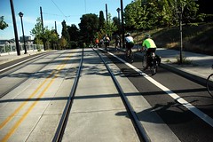
routed up onto the sidewalk
to get around the streetcar
platform. (Photos © J. Maus)
The Lovejoy design (see photo at right) creates a “very uncomfortable situation for most bicyclists,” added Birk. “It feels really weird to go up on the sidewalk and blast through a pedestrian zone, and when you’re on the street you have to cross tracks at a bad angle.”
This time, Alta (the planning firm where Birk is a principal) has completely redesigned the Pearl District’s bike facilities in the area surrounding the streetcar tracks, starting with the removal of the bike lane on Lovejoy. Instead, the streetcar plan would convert Lovejoy and Northrup into a one-way couplet for cars and reroute bike traffic onto a bike boulevard along Northwest Marshall. The cobblestone street would be smoothed out to accommodate bikes and would include new bike signals and bike boxes along the route.
“That was the first time the city agreed to give up a bike lane it already has. That’s a very significant statement of trust to believe it would be better for bikes than to keep the lane. That’s a mark of maturing as a real part of our system.”
— Rick Gustafson, executive director of Portland Streetcar Inc.
“That was the first time the city agreed to give up a bike lane it already has,” said Gustafson, who’s still looking for a way to pay for the proposed bike improvements in the Pearl. “That’s a very significant statement of trust to believe it would be better for bikes than to keep the lane. That’s a mark of maturing as a real part of our system.”
“Absent a strong city and regional policy saying cycle tracks and bicycling is really important to the future, it’ll take a while. These are major changes to our street system and they get a lot of resistance.”
— Rex Burkholder, Metro Councilor
The second area of focus was the Lloyd District where preliminary designs for the streetcar along Northeast 7th Avenue sandwiched a bike lane between the tracks and a row of parked cars. A redesign led to plans for a raised cycle track along 7th between Weidler and Northeast Irving Street that would physically separate the bike lane from the roadway.
The problem is, the plan still doesn’t include a connection from the Lloyd District to the central eastside, said Birk. In essence, the cycle track doesn’t go anywhere.
The streetcar planning committee considered options beyond the Lloyd District, where the streetcar route extends along MLK and Grand, but decided against including bike facilities despite a last-minute plea from Metro Councilor Rex Burkholder. In a Nov. 19 letter to then-Commissioner Sam Adams (download it here, 28k PDF), Burkholder outlined a vision of installing a cycle track on MLK and Grand. But the plan would have cut a lane of car traffic on a designated freight route and infuriated the business community, said Gustafson.
“Absent a strong city and regional policy saying cycle tracks and bicycling is really important to the future, it’ll take a while,” said Burkholder. “These are major changes to our street system and they get a lot of resistance.”
down into the South Waterfront
neighborhood.
In the meantime, Metro is almost finished with a new transportation planning model that will consider bike trips as well as car trips in multimodal street design. Current models account for changes in car traffic as a result of the streetcar tracks but can’t predict the reduction in traffic that could result from improved bicycling facilities that could entice more people out of their cars, said Burkholder. Metro will begin testing the new models next month and plans to roll them out for all its projects this summer – that’s still too late for the eastside streetcar, however.
“When we step back, every single one of those rail lines should be designed with the idea that cyclists will be in that corridor, that’s really what we should have done,” said Birk. “The elephant in the room is King and Grand; I’m very sad a bike lane or cycle track hasn’t been part of the project.”
— Read Part One of this story here. For more of our special, In-Depth news reports, visit our In-Depth News archives.


Thanks for reading.
BikePortland has served this community with independent community journalism since 2005. We rely on subscriptions from readers like you to survive. Your financial support is vital in keeping this valuable resource alive and well.
Please subscribe today to strengthen and expand our work.
Are bike lanes really effective when they stop and start and don’t help you get from NE to SE? That’s my biggest frustration. Random bike lanes that help sometimes but disappear. What’s the point?
A rep from Portland Streetcar came to our neighborhood association to discuss the possible expansion of the system (back) into Portland’s neighborhoods. One of the things that really struck me was the notion that they want these lines to create livability by making shopping and services reachable within a “20 minute trip” . . . and I remember thinking to myself how anyone with a bike in my neighborhood already has this reality, without spending MILLIONS of dollars. Add to this the fact that streetcars in my neighborhood would likely displace bikes, and do not offer the same exercise benefits . . . and the equation gets a bit crazy. I came away with the impression that the real reason behind the plan is to prompt the development of higher density residential and commercial projects along these corridors . . . which of course would remake many of Portland’s neighborhoods into Linear versions of the Pearl district, surrounded by single family homes. I like seeing the infill townhouses and reasonable scale commercial projects that are transforming my neighborhood into a more livable place. Streetcars, as much as I love them in theory, may have some unintended blowback, especially if they are run off of our major thoroughfares and into quieter areas.
For those who think Lovejoy is a good idea… pay attention. I’ve had more close calls there than any other street in Portland. On a bike you are sandwiched between the streetcar tracks on the left and car doors to the right. It’s a terrible place to be on a bike and should be avoided.
Marshall is bumpy, but at a much better alternative.
Funny about the Elephant in the room…
I went to a future conditions meeting for Beaverton (with a focus of 2009 to 2035), and they were pointing out all the needed connections for ped/bikeways, and completely overlooked the obvious corridor that isn’t being served…
Hwy 217 and the WES. If we could get a I205 like MUP, I suspect that bike commuters would flock to it, and bring down the number of cars, and bike/car collisions along major streets in Beaverton.
I put it into focus for them, but there needs to be demand.
The actions (or lack thereof) that we do now will ring until nearly the middle of the century. So, are you going to sit there? or are youg going to make demands?
Maybe I’m being obtuse, but a cycletrack on 7th from Weidler to Irving would drop you off on Lloyd Blvd, which takes you to the Esplanade, which takes you more or less parallel to MLK/Grand. I’d much rather ride the Esplanade than on MLK/Grand, with or without a cycletrack.
cyclist #5
I’d rather ride the Esplanade too, unless I’m going someplace on MLK/Grand (River City, for instance,) or I’m in a hurry and the weather is nice, (in which case the Esplanade is full.) Maybe they should build a 12 lane Esplanade, (I bet it would be less work to get an earmark for that than for a 12 lane CRC.)
If they cut a lane out of Lovejoy there’d be more than enough room….. 🙂
It’s good to see more streetcars coming to town but I don’t understand the need for bike lanes/routes/cycle tracks to be in such close proximity.
I use the NW streetcar often, when it’s available. And I bike around there often too, always on a different route. What I’m getting at is, if there’s a streetcar that goes down MLK/Grand, why does there need to be a bike lane on the same road?
K’Tesh:
Regarding a 217 MUP, I’d use it. I think if they just reworked some of the existing Fanno Creek facilities to be more bike friendly (like the Hall Rd. crossing for instance)and less underwater it could make for a much better experience along much of the corridor (maybe even a bike specific path along Fanno Creek that was signed for bikes and straighter than the current MUP). They would really just have to add a MUP along 217 north of Allen and south of N Dakota.
I also wonder why people are so focused on putting bike routes on the same streets as rail-traffic. I’d rather be a block or two off the tracks myself.
What I would love to see is a bike boulvevard for the entire length of NE and SE 9th Avenue. Currently you can ride it all the way from SE Holgate to NE Lombard by using the bike/ped bridge over Powell, taking a short jog up to the 12th ave bridge to cross I84 then back to 9th, though Irving Park, and then navigating the 45degree streets just south of NE Dekum. I use the 9th ave route quite a bit as it is but it could be a whole lot better with a few changes:
A bike/ped bridge over I84.
Removing the currently FREE streetside parking where possible.
Adding bollards and other traffic diverters.
Turning all neighborhood stop signs to facilitate N/S traffic.
Adding bicycle/cyclist triggerable signals at Division/Hawthorne/Morrison/Belmont/Stark/Burnside/etc…….
All of this would give us an excellent inner eastside bike route for much less money than designing a cycle-track around currently existing plans for the MLK/Grand revamp. (why would I want to be sucking up all that exhaust anyways while I cycle by an idling parking lot?). It would provide excellent connection options to the Springwater track, esplanade, and the currently existing E/W bike boulevards.
The key would be adding signage to currently high traffic streets such as MLK/Grand/7th 11th/12th etc. Let drivers/cyclists/(future) rail riders know about the route, no secrets!
The esplanade is a wonderful asset to Portland for cyclists, walkers, tourists, etc. It’s a flagship of what we’re about. But what it isn’t is a reliably fast efficient way to get where you are going in all cases. If the weather is nice, you’re forced to slow to a walking pace over and over or you’re taking chances with your safety and those around you which is decidedly not cool. Many times, I’ve experienced the tourist’s “random step backwards” because they’re taking a photo or otherwise oblivious of the MU in MUP.
I’m happy to see the rapid yet incremental progress that is being made. The lack of cohesiveness *is* problematic and highlights the complexity of the task. But I hope that this will create demand and generate enough cyclist flow through problematic intersections to increase safety by pure numbers. Then, as we prove out ridership and routes, we’ll be in an even better position to demand that the broken pieces get resolved.
I’d love to see a NE to SE route somewhere between MLK and 60th that is safe enough to where I’d want my kids on it. There are passable routes but nothing of the caliber that will allow me to do this.
So is this snake-like bike lane in Portland an effort to get over this problem?
I hope they keep the cobbles on Marshall street – except in the bike path. They look nice, are more durable than asphalt and slow the cars a bit.
On another note, the streetcars should be in the middle of the street when possible, not in the right lane. It’s done well on Harrison Street. A full-length cycle track would be good on lovejoy between 14th and broadway.
why not a bike blvd on nw johnson street to replace the lovejoy lanes? i prefer to ride on this street anyway over lovejoy.
i wish they could find a way to improve the bike situation in the lovejoy area without ruining the cobblestones on marshall.
why dont we bring jan gehl to portland to plan bike and pedestrian infrastructure? 🙂
Well, if they’re turning Lovejoy and Northrup into one-way streets, I’ll have no problem simply cycling in the lane adjacent to the tracks.
As for Marshall, I hope they keep as much of the cobbled surface as they can, with something like a few foot wide line of smooth concrete or asphalt for cyclists.
Hum, I don’t know if I like the idea of Marshall as a bike boulevard. I work at Good Sam and two of the parking garages enter/exit onto Marshall between 21st and 22nd…and Marshall doesn’t exist between 22nd and 23rd – it’s all Good Sam. Johnson or Overton would probably be better choices for a bike boulevard
With all respect to Mia Burk, who has been a champion for Portland cycling and accomplished so much, even in difficult political and funding climates, I totally disagree – I think MLK & Grand are no place for bike facilities. I think that a bike boulevard 1-2 blocks over would serve cyclists much better until such time as the vehicle traffic on MLK / Grand begins to drop. Designated freight routes are unpleasant for cycling, and in opposition to everything that defines that mode of travel – enhanced sightline and hearing, the ability to converse with another cyclist, freedom from polluted air – all of these things are enhanced by leaving a buffer of 1-2 blocks between a heavy freight route and a heavy cycling route.
My new mantra is – bikes should share the same infrastructure with cars wherever practical, and where it is not practical, parallel infrastructure MUST be provided for human-powered transport. It’s a civil rights and social justice issue, protecting transportation minorites.
The flipside of that is knowing on which roads the modes should NOT be combined. I believe that the MLK / Grand couplet (and MLK further north) is one of those routes.
Matt
I agree with your new mantra. But it sure goes to show that motor vehicles don’t play well with humans!
Regarding the NW Marshall bike boulevard and alternatives, NW Johnson and Overton are ALREADY bike boulevards. Marshall is being added as an alternative to make sure there is a boulevard in close proximity to Lovejoy to provide access to the destinations on Lovejoy.
I’m still not sold on the idea of streetcars in the first place. Why are they better than buses? They are much more expensive to build and maintain. Their routes are fixed. They are much more hazardous for bikes.
Chris: I still don’t like the idea of Marshall as a bike boulevard due to the proximity of Good Sam and all the clinics on it’s campus. I think it would be potentially a serious safety issue, especially given the age of the patient population. Moving the entrance/exits to the parking garages on Marshall isn’t really feasible – it would move onto Lovejoy, at least for parking #2.
If Johnson and Overton are already bike boulevards, then Kearny would suffice as an additional one for proximity to Lovejoy and it’s destinations without the safety issues that having Marshall as a bike boulevard would cause.
NW Johnson is a pretty good bike route, but it has far too many stop signs and motor vehicle traffic to be considered a ‘bike boulevard’ at this time.
I’m curious about why Portland has become such a bike culture city when it’s such a dangerous and uncomfortable city to ride in? The cops are unfriendly too!
Maybe Broadway/Weidler is a couplet where we can get things right, at least as far east as NE 24th Avenue. Bike lanes on the right, Streetcar on the left. With three lanes most of the way, there is plenty of pavement for sharing, and more signals and Streetcar should help reduce excessive speeds.
Development potential could simply be in addition to several projects…6 stories with retail…already built along the couplet. Streetcar will only go where property owners along the route not only want it, but are willing to pay for a good portion of it.
I think it’s ironic that the “business community” would howl over losing a lane on MLK. I hate MLK in NE Portland. It’s almost as bad as having an interstate bisect my neighborhood. I have had multiple incidents on MLK with cars both as a pedestrian and cyclist. Crossing MLK is an unpleasant ordeal, the volume and speed of the traffic make it unfriendly to bikes, peds and people who simply want to go to the shops and restaurants that are struggling there. I would like to see MLK become a smaller, friendlier street. I think the freight traffic should stay on I-5 where it belongs. As it is now, MLK and its high-volume auto traffic dominates the neighborhood, rather than the people and businesses that live and work there.
fredlf (#24) – I can sympathize with the difficulty crossing MLK, and better engineering might help some of those crossings. As for taking the trucks off MLK and “putting them on on I-5 where they belong” – that’s just not practical. The reason MLK is a truck route is because of all the businesses on and along it – it has to be a truck route in order to deliver to the major businesses on that road, and in the blocks around it near the intersection with Broadway. Further down, it serves to allow freight access to the entire Eastside warehouse district.
The key is to minimize the number of freight routes, and to separate out human-powered transport onto parallel corridors. In some cases, there are too many busy streets too close together – Alberta and Killingsworth are a good example of this. MLK / Williams / I-5 / Interstate is another example. Unfortunately we’re stuck with the road locations where we have them (and ditto for businesses), but there’s some work that could be done to discourage motorized traffic.
How would it be if they made MLK a 2 lane road with bikepaths? Interstate ave used to be 4 lanes and now 2. If they ever get I-5 widened out to a decent size people won’t be trying to scoot up MLK and Interstate to avoid the crawl. I feel sorry for pedestrians trying to cross MLK, it’s not a safe street. I think portions of it should be looked at and re-examine its purpose….