Multnomah County has released the Draft Environmental Impact Statement (DEIS) for the Sellwood Bridge Project. Included in the DEIS are details of the five bridge design configurations that are being considered.
Now, the County needs your feedback to help them decide what type of bridge to build.
The Sellwood Bridge is a major barrier to biking and better bike facilities on it would open up a host of possibilities for all types of riders — whether you’d enjoy a weekend riverfront spin, a safer, more efficient ride to work, or both.
One of the five alternatives includes a separate bike/ped bridge. It’s a pretty exciting prospect. Here’s the description from the county:
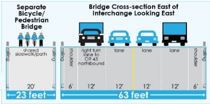
The bicycle/pedestrian bridge will be 23 feet wide, with 20 feet for bicycle/pedestrian use and 1.5-foot railings. Its alignment will extend from the Springwater Trail on the east side, above the parking lot of Sellwood Riverfront Park, over the river to north of Staff Jennings, and across Highway 43 to connect to a Riverview Cemetery access road as recommended by the Bicycle/Pedestrian Working Group. Ramps from the bicycle/pedestrian bridge will also connect to the Greenway Trail on the west side.
And a cross-section drawing:

It’s exciting to see a separate bike/ped bridge included in the DEIS and it would be great if the County heard a lot of support from the community about it. One thing to keep in mind as you submit your comments is that the preferred alternative that’s eventually selected will very likely be a hybrid of various components (like interchange design, bike/ped facility, where the bridge touches down, etc…), and will not be a carbon copy of any one of the five alternatives.
Comments can be submitted in person at public hearings or online and will be collected through December 22nd. All comments will be given to the project’s Community Task Force and the Policy Advisory Group to help them select a “Locally Preferred Alternative.”
More information on other designs being considered available at the excellent project website, SellwoodBridge.org.


Thanks for reading.
BikePortland has served this community with independent community journalism since 2005. We rely on subscriptions from readers like you to survive. Your financial support is vital in keeping this valuable resource alive and well.
Please subscribe today to strengthen and expand our work.
Also, keep in mind that it isn’t strictly a “vote.” You can’t just say “I like Option #X” (well you can, but it is unlikely to change their minds,) but a better comment is “Option #X with the separated bicycle and pedestrian facilities will encourage more bicycles and pedestrians trips and less automobile trips because they feel safer when they aren’t aren’t close to motor vehicles, and this is a good thing from a global warming perspective.”
A great comment is one that says “You didn’t include the impact of a carbon tax in you analysis. In the next 20 years it is likely that one will be passed, and this will result in decreasing motor vehicle traffic, and increasing bicycle and pedestrian traffic.” (Assuming of course, that they didn’t include that impact, which, not having read the EIS, I can’t say for sure that they did or didn’t… But you get the idea: Pointing out things that they should have thought of, but didn’t, is where you really make an impact on EISs…)
1.5 ft railings? As in 18 inches? Personally, I wouldn’t be too worried since it’s just water beneath the bridge, but some folks might get a bit freaked out.
Nevermind. I see that it’s the width of the railing and not the height. Sounds like a good idea.
no railings would be a sweet look.
I think that is the width of the railing, not the height.
You could easily die falling of a bridge in Portland. You just have to hit the water slightly wrong, and you’ll be knocked unconscious and drown, (and if you hit it very wrong, you’ll break your neck.) I think there is a suicide prevention information sign on the Broadway bridge.
http://blog.oregonlive.com/breakingnews/2008/07/sellwood_bridge_closed_in_both.html
I see nothing wrong with the proposal.
The 18 inches is the width of the railing. I am guessing they will be 3 to 4 feet high.
If the bridge needs to have at least 3′ shoulders, why not double their functionality and make them functional bike lanes, at least 6′ or 6.5′ wide?
If shoulders weren’t needed, I would, as a cyclists prefer a Hawthorne-bridge-style sidewalk with enough room for cyclists and pedestrians. With the expected number of pedestrians, it might even be acceptable to make the sidewalks somewhere in the range of 12′ to 18′ wide, but only to reduce the overall size and cost of the bridge, not to add vehicle lanes.
As it appears that shoulders are in fact required, why not make them double as large-enough bike lanes?
The vehicle congestion problem would not be solved in any way by adding more lanes, as the bottle neck would simply be moved to either side of the bridge. The real solution to that specific problem would be to look at a bridge in the vicinity of Lake Oswego.
In the aforementioned aspects, along with the second lowest average cost, along with the absence of a closure, D is clearly the best option.
John (#7) and others: ODOT and the County wanted to look at the option of removing bike and pedestrian activity from the west end, specifically for the roundabout and trumpet interchange alternatives. Ideally, this would improve safety for bikes and pedestrians in the area, as well as optimizing free-flow for motorized traffic.
That’s why the alternative with the new separate bike/ped bridge and the alternative with bike/ped below the roadway, do not have sidewalks or bikelane shoulders on the roadway.
With these alternatives, it is possible that use of the exclusive bike/ped facility would be mandatory, and bikes using the roadway could be banned.
I think the separate bike/ped bridge would be nice… but there are a couple of things that lead me to prefer a combined facility:
– at night you might be lonely out there, which could cause hesitation among some people with safety concerns. On a combined facility, even if you are the only cyclist or walker in sight, there are cars passing and drivers watching. (This is also the main reason I don’t like the option of a bike/ped path under the main bridge.)
– I may be harder to keep fast cyclists and casual walkers separate on a bike/ped bridge, even with distinct marked lanes. The advantage of the combined facility that has both bike lanes on the road and a wide shared path is that the fast riders can blitz through alongside vehicles without worrying about someone stepping in front of them and kids or casual riders can meander along the shared path.
– and finally I worry about a political backlash against a separate facility. Even if it costs the same as a wider combined bridge, it could become a visible target for those who oppose bike/ped investment. With a combined bridge it can be easier to see how the new facility helps everyone together.
Bottom Line though is… things are going to be sooooo much better.
One message we need to proclaim loud and clear is to learn the lesson of the Hawthorne: don’t skimp on width because the bike/ped use will blossom as soon as the bridge opens.
I agree with Andrew H’s points for a combined facility. I suspect it is in the long-term interest of bicyclists to advocate for sharing the public right of way and encouraging a multi-modal streetscape. To this end, Alternative D would maximize space for bikes and peds while Alternative E adds in transit. So far a mix of Alternative D and E would get by vote over Alternative A’s separate bike and pedestrian bridge.
Jim Labbe
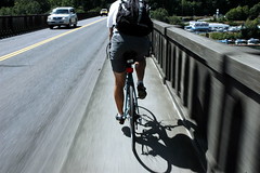
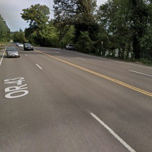
the great news about this is that all of the schemes have avoided a 4-lane bridge layout (the photo is slightly deceiving since that shows right turn lanes on the west side.
Thanks to Mia Burke, all of the schemes provide for adequate bicycle lanes which are as good or better than the Hawthorne.
Thanks Mia!
Matthew (5): I realize that falling off a bridge into a river can have fatal results. Unfortunately, I don’t have the energy to word things in the correct way to convey sarcasm on the internet.
Another important thing to consider when discussing the bridge options is the length of closure. Some of the options would have no closure while others could be up to 48 months. Four years without any bridge would be horrible for anyone living in the surrounding neighborhoods. A no closure option would be highly preferable for that reason.
My major objection to the separate bike/ped bridge is that it will over shadow Sellwood park from the south side, changing what is now a beautiful open and sunny place to enjoy summer concerts to a much darker place. I also wonder how this will hookup with the cemetery route on the wast side.