Local academics hit the curbs of the Lloyd District Friday to gather data that’ll examine Portlanders’ attitudes toward the neighborhood’s newest protected bike lane.
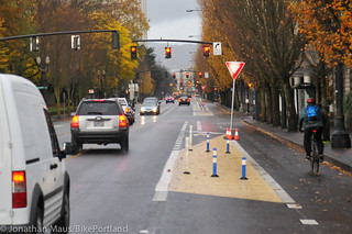
Separated from autos by a wide strip of beeswax yellow paint, a few parking spots, some plastic bollards and a set of concrete planters, Multnomah Street’s protected bikeway was the signature bike project from former Sam Adams staffer Tom Miller’s brief stint running the Portland Bureau of Transportation. It’s now part of a six-city study of how protected bike lanes are working.
The study’s leaders are Chris Monsere, Jennifer Dill, Kelly Clifton and Nathan McNeil, all of Portland State University. At the Oregon Transportation Summit last month, Monsere and Dill presented results from San Francisco, Austin and Washington DC suggesting that the protected bike lanes studied tend to be better-liked than unprotected ones among people using both cars and bikes. But they also found that the lanes didn’t lead to immediate spikes in the number of people biking on the street.
The study is happening even as the Federal Highway Administration prepares to gather information assessing whether the new designs are safe enough for a full-throated federal endorsement. With this data emerging at almost the same time, these results are likely to be closely watched by whichever professionals end up preparing the federal study.
The research is funded by PeopleForBikes’ Green Lane Project (full disclosure: my other gig; but we cover them only at Jonathan’s request) and by the Oregon Transportation Research and Education Consortium.
Separation like Multnomah’s is modeled after similar designs in use around the world and increasingly common in U.S. cities. (Canadian ones, too — the first North American city to use them widely was Montreal.)
Before installing it last year, the City of Portland described Northeast Multnomah’s design as a low-budget draft of what the street would eventually look like. With one of the city’s biggest apartment projects ever going up on this street (and offering fewer residential auto parking spaces than it’ll offer apartments) we’ll be interested to see what further changes might be in store.


Thanks for reading.
BikePortland has served this community with independent community journalism since 2005. We rely on subscriptions from readers like you to survive. Your financial support is vital in keeping this valuable resource alive and well.
Please subscribe today to strengthen and expand our work.
Let’s see how well it works after they build that 650 unit apartment building. There will be other developments going up also. The mall has new owners and hopefully will make it more attractive for shoppers. The high price of parking down town is going to push shoppers out of town to the malls.
The high price of a trimet ticket $2.50 x 2 = $5 for a round trip to downtown for 2 hours; $7.50 if you stay downtown longer, so parking is as cheap or cheaper.
An all day ticket on TriMet is $5.
Didn’t realize it had changed. Didn’t it used to be $10
Nope. A daypass rose from $4.75 to $5 in 2011, but it’s never been higher than the current $5. https://docs.google.com/a/portlandafoot.org/spreadsheet/ccc?key=0AnxdlXL8sAh3dGZlWUdXdEJCVjVWempqLWEyTGdPOUE&hl=en#gid=0
Who wants to ride a bus?
Portland has a big problem now because it has not kept up with its supply routes in its infrastructure. This might turn out to be a big mistake.
As a driver and a biker, this looks good to me. Hope it works.
I love it!
The key point…is that most operators of motor vehicles do not like to drive so close to operators of bicycles and would rather have a buffer of some sort. The same as most cyclists…would rather not be run over.
For too long the only option was to not have bike traffic or make it so nasty that there were too few cyclists to be a “problem”…you know those edgy urban cyclists who could dark at you at any moment (even if it was for some good reason like glass of a pothole that most drivers do not see). It is good to have this new buffered option.
And it is refreshing to see PBoT start “fixing” those urban arterial “mini highways” that try to do too much (move too many cars too fast with many lanes and parking and buses etc.) and thus by doing too much they do not do anything great at all…other than generate collisions and stress.
Hawthorne / Division etc, are like that – roads that I do not like to drive along, bike along, or walk along.
I love it–use it every day–but the thing is, I’m hardly ever sharing with anyone. Ever. Not sure why it’s so little used.
*Conflict at mall parking lot access points/mixing zones.
*Left turns are tedious and have increased risk versus taking the lane.
*Right hook risk is increased due to poor sight lines at intersections.
*Design is confusing and non-uniform.
*Leaves, debris and standing water in bike lane.
*Passing slower traffic is impeded by unnecessary obstacles.
Though, to be fair, how hard is it to wait until a legal lane change opportunity that doesn’t involve driving on a median in the first place? We’re talking a few hundred feet, tops. BFD.
Long term, more narrow but taller permanent planters/dividers could be built instead of just using paint and plastic. That would give enough room for bike passing mid block…. but of course we need funding to do things with actual cement And plants…..
A protected cycle track that spare_wheel would like? Something tells me that such a thing doesn’t exist.
I know I come across as grump here but I’ve ridden absolutely fantastic separated facilities in europe. For example, I’m a huge fanboy of fietsroutes:
http://www.fietsfilevrij.nl/routes/
Unfortunately in the USA planners tend to mix cycling and peds on physically-separated paths.
Busted! 😉
cus it doesn’t go places people go! I just have little need for it and live in the area
Exactly.
My experience is similar to spare_wheel’s. I had high expectations for this route. But even after riding it a dozen times, it is stressful to navigate the markings that change every block while simultaneously watching out for cars zooming in and out of parking lots. Turning left is difficult, and major portions of the route have continuous deep gouges left over from re-striping, something I find distracting and nerve-racking wherever it occurs.
I am all for protected bikeways, but Multnomah doesn’t feel like the real deal. I care less about the aesthetics and more about consistency and protection at intersections and driveways. If this is the “draft”, I look forward to the final version.
Nothing connects to it.
It would be a great route if it didn’t have stoplights on seemingly every. Danged. Block. I tried switching but it is infuriatingly slow. Time the lights at 22.5 mph, and you got something. But I found that every day I had to stop at almost every light.
Heck timed at even 15 would be nice…
Yep, this is why I stopped riding it. The light timing is terrible. I take Broadway instead and shave about 5 minutes off of that 20-block stretch.
That’s the problem with signal timing on two-way streets. You can’t get green waves in both directions…
I love utilizing the separation and comfortably riding/talking side-by-side with my friends when we are going to a destination along the route – hopefully there’ll be more of those destinations (aka businesses where I spend my $$$, wink wink business owners) in the future with thoughtful development!
However, until we see a project like this in Portland that requires political guts to implement on a major commuting route (or at the very least close to a major commuting route AND where the design continues for more than 20-ish blocks to entice riders to go out of their way to take full advantage of it), I doubt we’ll see many people immediately switching over in large numbers within the first year.
Also, it doesn’t help that Multnomah is a two-way street, if the main goal of the project is to create a more attractive alternate route, since the signal timing is so much tougher for two-ways than one-ways. It’s certainly attractive in some ways – just not in the way of saving time when one is in a hurry to get to/from work when they have so many one-ways nearby to choose from.
So…let’s not write-off these physically separated designs until we do it along a stretch of road that is just asking for it. Until then, I’ll enjoy Multnomah the few times I have a reason to go that far out of my way to enjoy those handful of blocks.
I think the route we should push for is to bring thhis design south via 21st/20th all the way to the new MUP underpass at SE 19th and Powell and the new 17th street overpass. This would require political will to fund and remove the 2+ miles of parking. Then pull it east on Holgate to connect to the Holgate bike lanes that end at the 205 bike path four miles east.
TD, When you gonna run for office? The street is about 36 ft wide, so, not much of a buffer – maybe 2 feet. You’d have to remove parking on both sides of a collector street that is a logical fire route, so slowing traffic is going to be difficult. Not many businesses would want to remain in such a corridor and homes without street parking, that’s a winner. Good luck getting re-elected. It would be easier to repurpose a lane on 11th/12th or Chavez.
Of course parking would have to be removed completely. No, I am not going to run for office (but I was a close adviser to a Dane County Supervisor in then middle 1990’s in Madison)….but the point was one of political will and lift. If we are going to get real commuter corridors that are family friendly some FREE on street parking is GOING to have to be sacrificed. Holgate in SE is the obvious choice because of the way everything lines up. We were talking about the need for long routes….do you have a better option for SE that is affordable?
In NE it would preferably be Killingswoth to Connect Willamette Bluff up with the bike lanes at NE 42nd. Again, we would need to remove parking completely. Eventually this city will a Have to do this on some corridors due to the narrowness of our streets in the “Central City” between I 205 and the river. They are waiting to suggest routes though until Metro’s Regional Active Transportation Plan is approved in 2014. Then, PBOT will have some direction.
Look at the debate about “The 20’s” Route. How much political pressure from PBOT will there be to remove parking completely on just that 0.6 mile stretch between Oregon and Stark. At least here it is a very short connection, but since there is 26th and the area is a heavily congested retail zone unless local residents PUSH for parking removal for buffered lanes it will not happen. Narrow 4 foot lanes in the door zone is unacceptable anymore. Going to the Burnside High Crash Corridor meeting and hearing what local residents had to say, I seriously doubt the neighborhood is going to want to remove ANY parking unless we inundate the outreach meetings. If this is the case, then PBOT should say….OK, but it HAS to be metered.
In the cases of 11th and 12th in SE, PBOT with their $6.6 million should say to the neighborhood and business associations: Do you want to remove a lane of parking OR a travel lane? Not frame it as “should we add bike facilitates”
“I seriously doubt the neighborhood is going to want to remove ANY parking unless we inundate the outreach meetings.”
Cycling mode share in that neighbourhood is among the highest in PDX and 20th is probably the most popular N-S route. Given the congestion on 20th I believe many residents would appreciate separate lanes for bikes and cars.
Many would, and there were many cyclists at the burnside meeting. Around 28th they were more interested in removing a lane of traffic on Burnside for pedestrian improvemnts, Parking because of 28th was “Important” And “already congested and getting worse with new apartment buildings.” On 20th, which is less commercial, it may be easier to get support for removal if those who realize the need get involved and go to the neighborhood meetings. There would need to be a region wide parking congestion study first which our working group thought was a wonderul idea.
The 20s bike route on 20th would be nice. PBOT is evaluating the 28th bike route, which may be our bread and butter as far as N/S bike routes.
the Low 20’s Greenway north of Ankeny could get you all the way to Lombard.
So will 26th/high 20’s. There will be some minor upgrades to the 21st avenue overpass (probably bale lane striping on those missing two blocks from Irving to Multnomah..again, requiring parking removal), but the 20’s route will be based on the 28th street overpass according to PBOT. The trouble will be south of Oregon to Stark…the bottle neck. How much is parking worth to the community? 26th works great if the intersections are upgraded and a path similar to the one built at Klickitat and 24th is built next to Davinci Middle school….but do they want this? Really, there are no direct choices and PBOT needs to frame it as “Which facility do you want….each REQUIRES this sacrifice for autos.” Automobiles have had free parking everywhere WAY too long in this city.
Here are our options for “The 20’s”:
http://a.tiles.mapbox.com/v3/coping-with-bikes.map-zsnzij82/page.html#13/45.5048/-122.6215
Is there a secret to viewing those maps, because they don’t open for me, just a grid appears.
What system are you using? They look fine on android and windows7 as far as we can tell and my data shows .there were 40 views in a short length of time. Sometimes mapbox does do system upgrades that blanks things out, but it is not often.
My less-confident partner prefers Broadway or Tilamook because she finds the Multnomah PBL stressful. For example, when heading North we typically take the upper Multnomah non-protected bike lane and then veer onto Broadway. She is, IMO, precisely the type of cyclist this facility is targeting.
Overall I like it, but I hate:
1) The beige paint. Besides looking icky, its meaning is not obvious. At first I thought the beige area was the bike lane until I pedaled further and found planters in it. What happened to the use of 45-degree hashed stripes (as often used in parking lots) to indicate no-go zones?
2) Not well set up for left turns. In several locations there are planters in EXACTLY the spot where I would normally want to be moving left across the beige median in preparation for a left turn.
Did they forget to put in left turn boxes?
The round planters are ridiculous. There, I said it. They should use a curb or other linear divider that actually follows the contour of the road. Gigantic round planters just make no sense as road dividers!
It’s not super amazing, but it’s nice enough that when I’m going eastbound off the Broadway bridge I now head south on Wheeler to Multnomah, rather than stay on Weidler.
i’ve ridden it several times. when you’re inside the barriers, it’s nice. it’s iffy at the intersections, in part because of the odd paint color. until these things are physically separated — elevated above the roadway, for example — they’ll be confusing & problematic.
and what concerns me most is that the bike lane in the N Williams Project is meant to be done with nothing more than the plastic posts as well. i hope this study convinces PDOT to install physical barriers that work, more in line with copenhagen, etc, practices.
A copenhagen-style cycle track is hardly physically separated. In fact, a genuine cycle track allows clean sight lines and and easy egress/ingress making it, IMO, a safer and more equal facility.
I wouldn’t mind purpose-built barriers in lieu of the ridiculous round planters. Plastic curbs could work, as they’re cheap. There are even purpose-engineered curbs for sale:
http://trafficlogix.com/productsservices/cyclelane
I really enjoy it. For those that don’t, are you comparing it to what was there previously, or to other bikeways in town? There isn’t much they can do about the driveway conflicts. We just need better drivers.
I walk along it regularly on my way to Blazer and Winterhawk games – and while I think the concept is a good one, at this point anyway it seems terribly underused. I can walk the length of Multnomah from the theater parking lot to the Moda Center without seeing a single bike.
I like it, but the data won’t mean much until you expand the network and make it connect to other routes. I can use it, but only from 12th to 7th; not all that much benefit. AND, I keep seeing the planters pushed into the bike lane (don’t know if this is from bored people or cars, either way, not a good thing).
I think Multnomah is great following this updated design. As others have said though, it just doesn’t connect to many destinations and it doesn’t provide full and convenient access to and from Point a to b.
I have only been on it a few times and over all I do like it. As others have stated, left hand turns are difficult unless you do a copenhagen left. And, unlike the buffered bike lanes on SW Stark and Oak, this is not near as confusing to out of the are motorist. And, much better site lines than the cycle track on SW Broadway where you are obscured by parked cars.
As far as no destinations? There is a very large movie complex there. And, it provides an easier access to the Lloyd Center from someone coming off the Eastbank Esplanade or crossing the Steel Bridge. Also a lot of very large office buildings where a lot of people work who may be more apt to try commuting now that this was built.
PBoT is learning by doing…the next ones should be even better and better.
Personally, I think it ruined the street for too many travelers. As a bike commuter I like the separation from the vehicles, however, I still think the Max line street, Holladay, would have been a, cheaper, smarter and less disruptive choice.
As a sometime bus rider I sympathize with bus commuters because bus stops were removed on Multnomah requiring riders to walk a lot farther to catch a bus. I feel that was too much to ask for a group that already has an inferior transportation option thanks to TriMet’s focus on everything but service.
And wiping out one lane for cars (which normally I’m thrilled about) probably just makes more people hate us.
In sum, though I ride home through Lloyd every workday, I rarely take Multnomah because it’s just not a street I like riding down.
On the bus stop issue: though not every bus rider is as mobile as I am, I think further-apart stops are in general great for transit riders like me. Shortening bus travel times is a big benefit, often worth the tradeoff against walking/rolling distances.
http://www.humantransit.org/2010/03/stop-spacing-the-endless-thankless-and-essential-struggle.html
http://www.humantransit.org/2010/11/san-francisco-a-rational-stop-spacing-plan.html
I agree Michael, that transit stops (bus and in some cases train) are too close together, slowing down the overall speed of the route substantially just so people can avoid walking an extra block or two to get to a stop. The tradeoff is too often made in the wrong direction.
As a heavy user of this entire route, I’ve come to dislike the new configuration less, but I still have several concerns.
There are several hotspots, namely traveling east at the movie theater parking lot. I think the buffered lane makes it more difficult for the driver to see, and drivers pull into and out of that lot very quickly. I would have bet money on a serious collision there by now. I suppose I would have lost that bet, but I still think that’s an incident waiting to happen. I’d tell my friends to always, always assume that all of those drivers do not see you on a bike.
The auto right turn lanes, coming out of the single lane, are another point of danger. Some drivers seem confused about why they are suddenly sharing a lane, some seem like they just don’t see the cyclist, and some knowingly see that they’re about to be prevented from making the right on red (if the cyclist gets in front) and hit the gas. I’ve seen a few close calls traveling west at both NE 9th and NE Grand.
Regarding why there’s light traffic? Because there is a much easier way to get everywhere you’re going, almost. Weidler/B’way are only a few block away, with a bike lane, and synchronized lights. Multnomah is painfully slow. The north/south green light on NE 7th takes an absurdly long time considering there are rarely that many cars. The red light at the movie theater takes forever with enough time for granny to walk across five lanes to see a movie (and it turns red, seemingly, without being triggered by anyone). It’s painfully slow. The benefit is that it can be very quiet, especially at night.
I agree driveways and right turns can still bring cars and bikes together, but that seems impossible to avoid. What is the alternative? The driveways and cross streets can’t be removed or individually signalized.
The bikeway works because there are unobstructed sight lines, plenty of roadway markings, and the bikeway is wide enough to maneuver. As bike traffic increases with 660 new apartments, drivers will become more aware of bikes, just as they are on other streets with a steady stream of bikes.
But, and this seems petty, I also don’t like the beige paint, because it already looks worn out. Since there is no traffic on it, it seems the paint should be more durable.
My only gripe so far is the lack of parking enforcement when drivers neglect to pay attention to signs and markings on the pavementThere have been several times since this lane revision that I’ve ridden through a gauntlet of inescapable door zone because one dummy parked in the buffer and a bunch of other dummies blindly followed. A physical barrier within the buffer, as shown in the photo, or the planters that line other sections of it, are a great solution to this, but right along Lloyd Center, the buffer is just paint on the asphalt.
This is my route from North Portland (home) to Hollywood District (fun), and other parts of SE, east of 20th. It feels super protected, one of the easiest places to ride in the city, only wish there was more bicycle infrastructure like it.
I have super mixed feelings about this design. I certainly ride Multnomah now when I didn’t before, but the inconsistencies, particularly around right-turn handling, are really problematic — no one knows what to do, so they do all sorts of things. The too-small parking spots are also an issue resulting in encroachment into the buffer. Many of the small posts have been knocked down multiple times and the paint is very worn at corners, indicating problems with cars entering the buffer or bike lane area. I emailed Ross Swanson (the project manager) about these issues last year (although at that time the paint wasn’t worn yet), along with a comment about some bus stops not having zones for the buses to return to the lane. The bus drivers are probably more facile with it, having had a year to learn, but I think it is still quite a difficult area to drive a bus.
I’ve also been in contact with Peter Koonce about it and asked him about the timing. He said there is no easy solution to improve it at this stage since it’s two-way and you can’t get a green-wave going both ways. I had good luck on this morning for some reason, but usually I find it frustrating and would rather take Broadway in spite of the hazards there. Timing is not just a convenience issue, but also safety, because I have seen lots of people run red lights due to no cross traffic and frustration, and myself have probably gone through more stale yellows than I ought to.
Because of the light morning traffic I’ve never had trouble merging at the Rose Quarter to turn left on the path, but in heavy traffic that merge would be difficult and there is no provision for it.
In short, nice idea but the actual logistics of the design need serious rethinking.