On Friday, October 14th you can get a sneak peek at TriMet’s Portland Regional Trip Planner, which they bill as the “first open-source, multi-modal trip planner produced by a U.S. transit agency.”
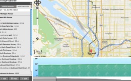
Over three years in the making, TriMet’s new tool will function similarly to how you get trip directions on Google Maps; but unlike Google Maps, TriMet’s trip planner will let you plan trips that combine transit, walking and biking into a single itinerary. Making it even more attractive is the fact that it uses all open source technology through a partnership with OpenPlans.
When Michael Andersen checked in on this project
for us back in July 2010, he called it the “holy grail” and wrote, “Suffice it to say, Portland’s transportation geeks are very excited.”
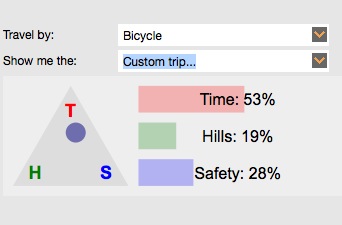
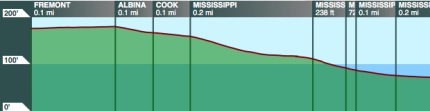
Beyond being multi-modal and open-source, the tool has other nifty features. One of them is a way to filter bike trip results based on how you prioritize of time, hills, or safety (see graphic above). The new trip planner will also provide you with an elevation chart.
You can play around with the beta version of the tool on TriMet’s website. The Portland Regional Trip Planner was funded through a Metro Regional Travel Options grant.
The public sneak peek at the new Regional Trip Planner is Friday, October 14th from 10:30 to 11:30 am in Metro Council Chambers (600 NE Grand). The official public launch will follow on Saturday.


Thanks for reading.
BikePortland has served this community with independent community journalism since 2005. We rely on subscriptions from readers like you to survive. Your financial support is vital in keeping this valuable resource alive and well.
Please subscribe today to strengthen and expand our work.
wow, took a quick look at the site. Really cool stuff. Definitely something I’d like to see my own city implement.
TriMet’s interns and I have been working for about a year now on getting bicycle and pedestrian data into the Portland area portion of OpenStreetMap, which is what TriMet’s using for the base map data and non-transit routing. I’m not sure where we’re at right now on getting transit routes imported.
Great looking website, very nice. It would be nice to show the travel distance in the trip details section. I can see it at the top in small print, but I’d include it by the travel time also.
I definitely like the concept behind bicycle preferences. The lack of this is why I never find Google Map’s bicycle directions useful. They assume I want the safest path when I’m really looking for the fastest and least hilly.
The TriMet interns actually had a hard time trying to reconcile Bike There! with this because OSM doesn’t presently have a method to rate safety of a route by bicycle as it tends to be too subjective, recommending routers take another approach to handling the issue based on attributes of the way (prefer/avoid bike lanes/tracks, major streets, side streets, dirt roads, etc).
This is a very neat site and appears to be another powerful tool, in addition to google maps and mapmyride, etc.
One interesting issue is that the elevation over of the B-side bridge shows the river’s elevation, and not the bridges.
Woah. I am so psyched about this! There are so many times that I’ve wished for a good resource for how to combine different forms of transit in one trip. Awesome!
This looks really great and I would really like to use it. However, I couldn’t seem to get it to route me onto the Springwater Corridor. Does it not incorporate MUPs and such? Maybe it’s just my ineptitude….
I am having some problems with getting a route to cross streets instead of an actual address. I’m assuming it’s because this is still in Beta, but it is very possible that I am also inept, especially since I’m only half way through my first cup of coffee at the moment. 😉
Could you both give me an example of routes that this is affecting? I can use that feedback to narrow it down to data or router, and if it’s router, pitch some suggestions.
From: 9233 SE Henry St.
To: SW Murray Blvd. and SW Jenkins Rd.
bike/transit
biking distance: 15 miles
left the time/hills/safety at the default setting.
I get the little arrow showing my starting point and my destination but then I get an error…
Error message: “Trip is not possible. Please check that your plan is within the bound of the map.”
I just tried it, and it looks like it’s working. Could it have been the trip time or bicycle distance tripping you up?
Possibly, I tried it yesterday with a different trip time/riding distance with the same error. I don’t know if using Google Chrome would make a difference. I’ll try it in FFox later.
just tried it with 30 mile bike distance with the same result, then I tried it with 1/2 mile bike distance and it worked… though it had me go to the 205 corridor path and then walk… lol
on that note, it looks to me as though it’s treating the bike distance as an absolute, not as I’m willing to bike this far, but I’ll ride bus/max if it’s faster…
For what it’s worth, “holy grail” was a phrase used by someone I talked to, but I didn’t attribute it at the time and I’ll stand by the phrase.
Anyway, I’m excited to see this groundbreaking tool in action.
This is AWESOME!! I love maps and this is an insanely cool planning tool. I was having a hard time with the custom trip function, however. When I planned a trip from my house (near SE 45th and Hawthorne) to my daughter’s school (Ainsworth on SW Vista) I could get the “safest route” which got me to a bus as closely as possible, and I could get the “fastest route” which had me biking the entire distance downtown on Hawthorne (yikes…) but i could only get a custom trip when I centered the dot in the exact center of the triangle (33%, 33%, 34%). At that point it gave me the route I actually take (a combination of Main, Salmon, Madison). All other custom trips gave me the error message noted above. Overall, this is the coolest map program I have used.
Projects like this make me love Trimet. Probably the most innovative and well thought out public transit in the country.
Yeah, my cities transit system (Santa Cruz Metro) has a thing or two (or 50) to learn from them…
A bus on a major route being 20 minutes late is UNACCEPTABLE!
A bit off the topic of this post, but I don’t think they can learn from Trimet that this is unacceptable. It just happened to me with the 14 yesterday.
I have also had that happen to me… on the 14 as well (foster and 92nd stop). But this happens almost daily here, While in PDX it was an infrequent occurrence. Not so here in SC County.
We have a few clarifications to the post about TriMet’s new trip planner. The link to the OpenTripPlanner (http://maps5.trimet.org/opentripplanner-webapp/) in your post was established last year for demonstration purposes only and is not current, nor does it have all the new mapping features and up-to-date data. The actual beta version will be live as of 9 a.m. Saturday, October 15. Your readers should be clear that the link in your post is not the accurate version of the new tool.
The new Portland Regional Trip Planner, which uses all open source technologies, including OpenTripPlanner, will not be released until next Saturday. We are very excited about this beta release and look forward to getting comments from the public on the official launch and working with the public and the bike community on future enhancements and improvements.
This project was funded by a Metro Regional Travel Options Grant, and development on the application began in July 2009. Releasing an official beta version in 27 months demonstrates the advantages of open source software.
TriMet worked with members of the OSM community on improving the data for this project for the past year. If you have questions or comments about this project or the OSM data, please direct your comments to rtpfeedback@TriMet.org.
This is so cool!
Folks at TriMet – Are you planning to integrate the planned/potential bike share system into this routing tool?
Thanks! Integrating the planned bike share program into the routing is defintely being discussed. Feel free to email rtpfeedback@TriMet.org for more info.
PJ
Trimet