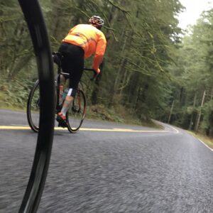
It’s really scary when you’re bombing down Larch Mountain Road and your fingers and core are nearly frozen because you didn’t respect the elevation and you come around a corner at 30+ mph and narrowly miss a crack or a pothole.
Ask me how I know!
That’s why I’m so excited to share that this road — one of my favorites — is now sweeter and smoother than ever thanks to a just-completed project by Multnomah County. The county spent about $5.1 million of (mostly) federal funds to repave and repair East Larch Mountain Road between mileposts 7 and 14. They smoothed it out, cut back vegetation, repainted the fog lines and centerline — and it’s now open and ready to ride after a three-month closure.
And related to aforementioned elevation (3,700 feet, highest road in the county), it will close again (at milepost 10) when winter sets in, so you better get up there and hit this new pavement while you can.
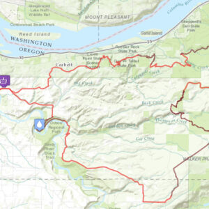
If you haven’t yet explored Larch on your bike, check out one of my favorite rides on Ride With GPS for a good route suggestion, elevation profile, and so on. Have fun up there! Just remember to pack gloves and extra layers for the ride down.
— Learn more about the paving project on Multnomah County’s website.


Thanks for reading.
BikePortland has served this community with independent community journalism since 2005. We rely on subscriptions from readers like you to survive. Your financial support is vital in keeping this valuable resource alive and well.
Please subscribe today to strengthen and expand our work.
From the photos it looks like they widened the car lanes and removed any sort of shoulder lane, so I’d say it’s quite the opposite of an improvement – less protection for cyclists and faster speeds for cars.
there’s never been a shoulder lane up there David. It’s a rural country road.
That’s correct, I’ve ridden up and down Larch Mountain Road and there never was a shoulder. And there’s no room to add one without heavily impacting trees along the road. It’s very constrained. But it doesn’t matter, because it’s a dead-end road that doesn’t get much traffic, and when cars come up behind you it’s very easy for them to pass and give you plenty of room. It’s really not an issue. Anyway, I’m happy to hear about this project! The smoother pavement will be a welcome improvement, especially going downhill at high speed.
exactly. Anyone who has biked up there knows that it’s relative safe and low-stress because so few people drive on it… and the ones that do are just pleasure-seekers who are taking in the view. Obviously some drivers present safety issues… but for a rural road without a shoulder it’s one of the safest I’ve ever ridden anywhere.
Larch doesn’t need a more of nature paved over — if you can handle the climb or descent, you don’t need a lane. Since when are bike lanes a thing on mountain roads anyway?
Going up is a grind but it’s low traffic. Going down, there’s no way you’d want to ride in a shoulder — cars won’t keep up anyway.
Just to illustrate the points made, here’s a Google Street View image from before the work was done. As a bonus, it has a large SUV/truck in the frame showing how wide the lanes are:
https://maps.app.goo.gl/Pe6WqunPetSTPFZ66
It’s a shame that they couldn’t have put in even a shoulder for biking on.
Especially after Adam Joy was killed with minimal consequences for the driver it makes me worried to bike on country roads: Witness version of fatal Polk County crash differs from police
Also 5.1 million for 7 miles of road seems extremely high
Nope, that’s a total bargain compared to any urban road repaving project. $5.1M in the transportation world is nothing.
This is one road that doesn’t need shoulders to be amenable to cyclists; up and down, car traffic isn’t an issue.
I’ve found that a great way to ease stress on country roads is by using a radar device like Garmin’s Varia. Being reliably alerted to approaching vehicles allows you to focus on what’s ahead and stay as right as possible in case you are about to be overtaken by someone not giving you the legal 3 feet. There are several million miles of rural rounds in the US and it’s not practical, nor in many cases environmentally desirable, to build shoulders. You can still enjoy them nevertheless.
SO AWESOME AND FINALLY!!!!
Thanks for the update. Nice fresh smooth pavement is a double edge sword: improves cyclist safety through smother ride but it will also likely allow for higher motor vehicle speeds.
Does anyone know what the traffic volume (ADT) is for this segment of Larch Mountain? Less than 6k? Crash frequency? I was thinking that its too bad that Multnomah County did not study if this roadway should have an alternative striping layout vs the one that they have been using for 70+ years…say like a Advisory Shoulder. Plus it looks like they did not install any reflector RPMs etc.
https://ruraldesignguide.com/mixed-traffic/advisory-shoulder
https://www.advisorybikelanes.com/uploads/1/0/5/7/105743465/advisory_bike_lanes_and_shoulders_article_in_december_2019_ite_journal.pdf
Maybe due to frequent snow plowing?
Multnomah County no longer posts traffic volume data on their website, it seems – but I’d guess the ADT is something like 3K on summer weekends, somewhat less during the week, since the destination is a viewpoint & hiking trailheads.
This is a great ride; it’s particularly enjoyable in the spring before the gate opens (2 miles or so from the top) but the snow is mostly gone, so there’s virtually no traffic at all.