
The Portland Bureau of Transportation has released their recommendations for which neighborhood greenways and bike infrastructure improvements should be prioritized in north Portland. The recommendations were released Friday afternoon and are the culmination of two years of planning and public outreach for the North Portland in Motion plan. We first covered this plan in April 2021 and since then, PBOT project staff have led bike tours of the area, identified a number of projects, collected feedback, convened an advisory group, and more.
Now we’ve got seven solid new neighborhood greenway projects, 10 “corridor improvement” projects, and six public space projects to rally around and push toward completion. Like all of their “In Motion” plans (of which they’ve already completed in the central city, as well as east, southwest, and northwest Portland) there is not funding attached from the outset. The value of these plans is that they give PBOT and publicly vetted, “shovel-ready” list of projects that have a much better chance of actually being built when/if funding becomes available. They also give advocates clear organizing goals and leverage to create awareness and support for specific projects.
Here are the seven Tier 1 neighborhood greenway projects PBOT recommends (click project name for PBOT doc with more info):
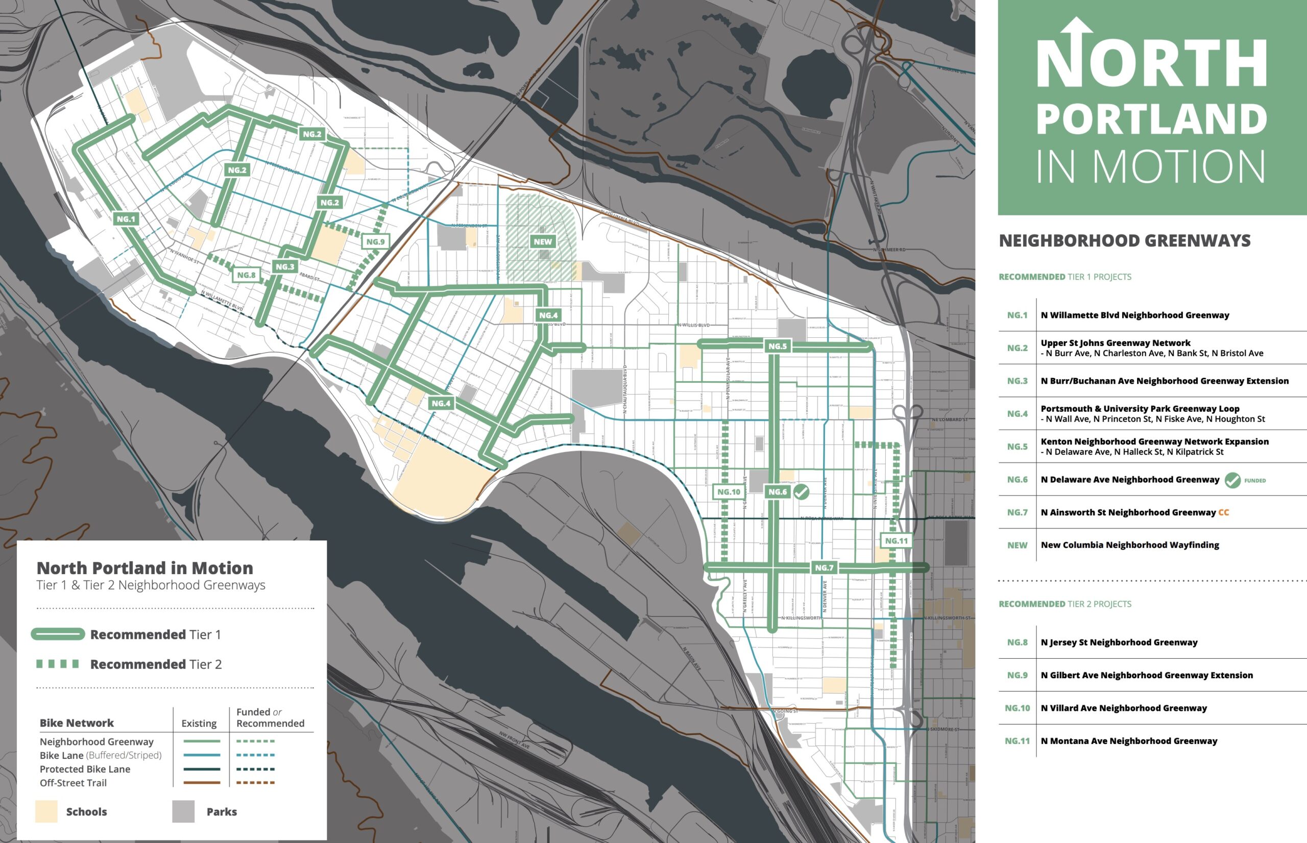
- NG.1 – N Willamette Blvd Neighborhood Greenway: New neighborhood greenway on N Willamette Blvd and N Reno Ave provides a connection to Cathedral Park and Sitton Elementary.
- NG.2 – Upper St Johns Neighborhood Greenway: A bundle of new Neighborhood Greenways in the northern section of St Johns intended to fill major gaps in the network, including investments on N Charleston Ave. Provides a direct connection to George Middle School, James John School, St Johns Library, St Johns Farmers Market, and Downtown St Johns.
- NG.3 – N Burr Ave / N Buchanan Ave Neighborhood Greenway: A new neighborhood greenway providing a north/south walking and biking connection between N Willamette Blvd and N Columbia Blvd. This route connects a number of important neighborhood destinations including George Middle School, George Park, Roosevelt High School, and businesses on N Lombard St and N Willamette Blvd.
- NG.4 – Portsmouth & University Park Neighborhood Greenway Loop: A collection of new and upgraded Neighborhood Greenways building out a complete and comprehensive network in the Portsmouth and University Park neighborhoods. This collection of projects improves access to schools (Astor Elementary, Cesar Chavez Elementary) and parks (Columbia Park, Portsmouth Park, McKenna Park). It also provide access to New Columbia, the largest affordable housing development in the State of Oregon.
- NG.5 – Kenton Neighborhood Greenway Network Expansion: A bundle of new Neighborhood Greenways on N Delaware Ave, N Halleck St, and N Kilpatrick St intended to expand and improve the network in the Kenton Neighborhood.
- NG.6 – N Delaware Ave Neighborhood Greenway: A new neighborhood greenway on N Delaware Ave providing a calm and comfortable route for people walking and biking between Kenton and Overlook neighborhoods. This neighborhood greenway provides a direct connection to Chief Joseph Elementary and Arbor Lodge Park and fills a major north-south gap in bike network.
- NG. 7 – N Ainsworth St Neighborhood Greenway: A new neighborhood greenway on Ainsworth St connecting the greenway and bike lanes on Willamette Blvd with Interstate Avenue. This project would fill a key gap in the biking network between N Rosa Parks Way and Willamette Blvd, and provide direct access to Ockley Green Middle School.
These greenways would double the density of the bike-friendly street network in the northern peninsula of our city and provide key links to important destinations like parks, schools and commercial areas.
Along busier streets, PBOT categorizes the projects as “corridor improvements” where they plan to do things like speed limit reductions, lane reconfigurations, transit access improvements, and so on. Here are the 10 Tier 1 corridor improvement projects they recommend:

- CI.1 – N Smith St: This project would improve and enhance existing pedestrian crossings at new Neighborhood Greenways, update existing all-way stops and median island crossings with improved crosswalks, and make minor changes to improve the existing buffered bike lanes. This project recommends continued investment in traffic calming to reduce speeds, monitoring, and evaluation.
- CI.2 – Cathedral Park Access Improvements: This collection of projects would invest in basic safety investments to improve access for people walking and biking between the waterfront area of Cathedral Park and Downtown St Johns.
- CI.3 – N Willamette Blvd: This project would implement lower-cost elements of the federally funded Willamette Blvd Active Transportation Corridor scheduled for construction in 2025-2026. These near-term improvements would include new marked crosswalks, improved bus stops, and new buffered bike lanes from N Alma Ave to N Richmond Ave.
- CI.4 – N Macrum Ave (St Johns): This project would add on-street parking, street trees, and high-quality buffered bike lanes connecting to bike routes on N Fessenden St and N Columbia Way. Additionally, this project would add a new crossings at N Columbia Way and N Fessenden St and include safety improvements at the existing signalized intersection of N Columbia Blvd.
- CI.5 – N Fessenden St: This project would add additional crossings, make safety improvements to the wide intersection at N Wall Ave, and reconfigure the roadway to provide a protected bike lane connecting St Johns and Portsmouth.
- CI.6 – N Portsmouth Ave: This project would add traffic calming and speed reader boards to reduce speeds on the corridor. It would also improve existing crossings and add new median island pedestrian crossings to help people get across the street, and upgrade the existing narrow striped bike lane to a buffered and/or protected bike lane.
- CI.7 – N Willis Blvd: This project would fill in the remaining sidewalks gaps, improve ADA access, improve existing crossings, add new speed bumps, and add additional safe pedestrian crossings. This corridor serves both TriMet Line 4 and Line 35 buses and PBOT will work with TriMet on bus stop improvements at higher ridership locations.
- CI.8 – N Woolsey Ave: This project would add traffic calming and new crossings to improve safety for people walking and biking and encourage slow, safe vehicles speeds. Though not intended to meet neighborhood greenway standards, these improvements would improve safety and comfort of people biking on this street.
- CI.9 – N Interstate Ave: This project would leverage an upcoming paving project to improve and extend the bike lane to reduce or close a major gap in the bikeway network. In collaboration with our partners at TriMet and ODOT, this project would also explore ways to improve the safety of people crossing at major intersections, many of which have high volumes of pedestrian activity for people accessing businesses and the MAX stations.
- CI.10 – N Alberta St: This project redesigns the layout of N Alberta St to provide a separated, comfortable bike lane connection between N Interstate Ave and the N Michigan Ave Neighborhood Greenway. Furthermore, this project would add bike boxes and no-turn-on-red at the signalized intersection at N Interstate Ave to reduce conflicts and improve pedestrian and bike safety.
There is so much to be excited about with many of these projects! Some of them (Ainsworth greenway! N Interstate!) are a long time coming and it’s great to see recognition from PBOT that they need help. In addition to the projects above, PBOT has recommended public space/public plaza projects at the St. Johns Plaza in downtown St. Johns, a mural on N Charleston Ave (in partnership with James Johns Elementary), a mural in Kenton, a plaza in Arbor Lodge Park and a mobility hub at University of Portland.
From here, the official recommendations will be shared in an online open house, then there will be a final public comment period this summer along with some community walks and rides to finalize the list. Then I assume there will be a date for official adoption at Portland City Council this fall.
Thanks to all the advocates and city staff who worked on getting things to this point. Can’t wait to report on many of these coming to fruition in the months and years to come. Let’s go north Portland!
Learn more about all the projects here.


Thanks for reading.
BikePortland has served this community with independent community journalism since 2005. We rely on subscriptions from readers like you to survive. Your financial support is vital in keeping this valuable resource alive and well.
Please subscribe today to strengthen and expand our work.
These improvements will be quite helpful, especially since the city appears to have ceded the Peninsula Crossing trail to the “houseless”.
Disappointing to not see the NP Greenway on the list.
Also, it strikes me that these IN-Motion plans have an inherent flaw for cycling- bikes often want to go to other parts of town. As an illustration of this, if you want to bike from North Portland to Central, Southeast , southwest or Northwest Portland, the bike routes funnel you you to Greeley or Interstate Ave which merge at the southern end of this In-Motion study area. But the connection beyond that is terrible- really narrow lanes on a bus/freight route and dangerous pinch pints where the lanes reduce to 18″ in one spot. That section of Interstate is in NE, but the NE in motion plan would not be inclined to elevate this segment of Interstate because it is not important to NE residents- they can use Williams or 7th. So the North Portland connection never gets addressed- PBOT keeps focusing on isolated segments but the interconnected network is neglected. Another example is Skidmore. Connecting the buffered biking lanes on Skidmore from where they end at Michigan to 7th (or 9th) would be a huge improvement to making connections from North Portland to NE and SE Portland as it provides a level crossing over I-5 with no interchanges, and signal-controlled crossings at Vancouver, Williams and MLK. However, the part that residents in North Portland need improved is in NE. I fear our new district-based form of government will exacerbate this. I would like to PBOT abandon this type of study, and focus on a City-wide biking and walking network so they concentrate on improving missing links and providing a higher level of service. This type of study seems relevant for pedestrians or parks, but not very good for cycling.
When we did the E-PIMP in 2010-12, we regularly discussed bike and transit routes to get EP workers along the Columbia Corridor to North Portland, as well as connections to Clark County, Clackamas County, and Gresham. PBOT wasn’t very helpful, but we did eventually start lobbying directly with Multomah County, TriMet & ODOT who then in turn lobbied on our behalf with the other counties and the Port Authority. Essentially the PIMPs are starting points – you have a basic city plan, now you need to work as a group to expand that plan to include other jurisdictions, school districts, agencies, etc. Just don’t rely on PBOT and BPS to do it – otherwise you’ll invariably be disappointed by the results.
The NP greenway seems like it would be very high risk of becoming another cross-peninsula trail. If the city isn’t willing to keep these MUPs safe and passable, I don’t think we should waste money on any new ones.
ChrisI- I get your point but I hate to give up, especially with an aspirational planning document. The Esplanade has had years of issues with campers, which is frustrating, but it has never become impassable like the Peninsula Crossing Trail. I agree that PBOT should not build any isolate trail segment, but if they made simple strong connection to the Esplanade (live a viaduct under the Steel bridge) and a path at the top of the bank from the Steel to Tillamook Street, I think that would get enough use to prevent a houseless takeover. I believe will continue to get better, and we should plan for the future we want and believe we can achieve. We cannot let the problems of today become permanent obstacles toa better tomorrow.
It sounds like what you’re describing is an update of the Bicycle Master Plan, which is 13 years old now and due for an update. The “In Motion” plans are more about connectivity within a certain quadrant.
Yes, that is what I am describing. I believe that the Bicycle Master Plan should be the the primary resource consulted, but in practice, it is overwritten (in effect) by the In-Motion plans. PBOT continues to build disconnected pieces of bike infrastructure and continues to neglect improvements to the overall network. I believe this is the largest contributor to the stagnation in bike ridership. I also PBOT’s focus on isolated segments versus network function is a symptom of trying to meet a metric established by the in-motion plans. I can see the value of gathering local knowledge to identify transportation needs, but I believe the In-Motion plans are in inherently flawed system for bicycle planning.
I’m very excited for these projects. Let’s get them built!
I don’t really understand the point of ‘greenway’ expansion as a project. Greenways are just normal streets with extra signs. Why can’t they “create” all the greenways at once, and send a crew out to put up the signs?
That Buchanan one is a joke. That’s a major through route for motorists and gets super fast in the morning at and at night as Clark County commuters speed through NoPo. We all know that PBOT wont install actual traffic calming infra on ‘greenways’ that would impede through motorists. It already has bike bumps, so, isn’t it already done?
Traffic diverters would be great. As much as I hate just paint, at least they could put down some road markings to let motorists know that they are on a bike greenway, and that cars are guests on that road like they do in Berkeley
I personally think that sharrows/beg barrels/yard signs are all not worth the cost of the materials they are made with. We know that asking or begging motorists to change their behavior doesn’t work. 90% of motorists using a ‘greenway’ to cut through traffic don’t know what a greenway is and 100% of them wouldn’t care either way.
I think these performative ‘greenways’ do more damage to cycling than anything else. It signals to new cyclists that certain routes are low-traffic when they aren’t. These performative ‘greenways’ also allow PBOT to pretend they care about road safety and cycling by expanding the bike network. If you look at PBOTs official cycling map, you’d think Portland is a cycling paradise, whereas the reality is 95% of the bike network is sharrows and gutter lanes.
If PBOT’s bike map only had segments that were protected by diverters, grade-separated paths, or even the little concrete jokes, it would show how little PBOT has invested in safe streets.
I agree. There are some quality greenways I’ve come across but so many of them are out of the way of destinations, don’t go in straight lines, still have cars on them, etc…
Perhaps PBOT needs to copy what Vancouver, BC does with it’s bike map and label an all-ages-and-abilities connected network as seen here: https://vancouver.ca/files/cov/map-cycling-vancouver.pdf. While it is not extensive, it does show off the higher quality connected infrastructure.
It’s now cool for cycling aficianados (and esp. numtots) to hate neighborhood greenways despite the fact that they are backbone of both Portland and Vancouver’s network (look at that map again, Daniel).
When those who claim to support cycling are often hostile to the infrastructure I use on a daily basis, it seems pointless to care about cycling infrastructure.
I don’t hate greenways, but I do think they are fundamentally limited in providing a truly connected functional bike network. I believe Vancouver recognizes this and why they don’t include most of them in the all-ages-and-disabilities network.
I use greenways too on a semi daily basis, I can be critical of them and wish for something better. A big issue issue I have with greenways is that for the most part they don’t include infrastructure. They are just local streets PBOT found that have low traffic, yet provide little to no convenience/comfort/safety when crossing bigger roads.
I’d be happy to discuss greenways but you’re response doesn’t touch on any of the criticisms I made.
So perhaps instead of criticizing the concept of greenways* we could demand diversion and signs that indicate priority (ironically that was one of the goals of bikeloudpdx).
* pakikala’s “full greenway standard” and the traffic calming policy guidelines outlined in the city’s neighborhood greenway report are a start
Can you give literally any examples of cycling aficionados who hate greenways?
I think you might be confusing a critique of PBOT’s intentionally poor implementation of the greenway concept with hating greenways themselves.
Are you kidding? Every day on BikePortland there are commenters complaining about being “hidden” on the neighborhood greenways and saying PBOT should only build bike lanes on busy streets. It’s pretty constant to hate on greenways on this website. Personally, I think they are the primary backbone of our system and I would always prefer to ride on a good greenway than even the best protected bikeway on a high-traffic street, because it’s always unpleasant to ride near heavy traffic. I also think you are severely mischaracterizing greenways in Portland. We have diverters on most of our greenways, and the ones that don’t have them generally don’t need them. Sure, there could always be ways to improve them. But compare to other cities who don’t even do diversion and you’ll see Portland’s greenway network is pretty great.
Huh? I’ve been reading bikeportland for like ten years and I have no idea what you’re talking about.
I think you are as confused as the other poster. I’m assuming you are referencing the discussion about Hawthorne. People don’t hate the greenways around Hawthorne, they just correctly point out that greenways are not an appropriate substitute for safe infra on the arterial road.
That’s fine, I don’t think there is anyone in the bike community who wants you to not be able to ride on a greenway.
That’s not true in any respect. Most greenways do not have traffic divereters and the ones that do have maybe one to cover 20 blocks when traffic diverters only protect 3-4 blocks.
PBOTs own traffic counts show greenways have far too many motorists on them. You are simply stating how you feel rather than basing anything in facts.
That’s a pretty sad was to measure success. Portland’s greenways are largely just regular streets, full of cars like all of our other streets.
? In Berkeley they have 20″ diameter concrete bollards that let people in cars know that they are guests right up to there, no more.
PBOT has been putting in diverters like crazy on greenways all over the city. About 10 diverters in NW Portland alone, and new diverters on Clinton, Lincoln, Salmon, Fremont/Alameda, etc. Why wouldn’t they put on Buchanan?
PBOT created new greenways in Overlook that don’t even have stop signs on the cross streets. They also added a much needed stop sign on the Alameda greenway, but guess what? It stops the greenway, not the cross street! Greenway can and should be great, but PBOT’s implementation is very poor. I had 3 (!) close calls yesterday evening just on Going between 29th/7th because PBOT allows large trucks/vans to park right up to the curb so cross traffic cannot see bikes coming. IMO, people are not complaining about greenways as much they are complaining about PBOT’s lame attempt to create them with diverters or parking restrictions.
E-PIMP had $8 million for sidewalks before the planning process even started – it’s partly why the plan was done in the first place – and 10 years later the city, county, ODOT, TriMet, and various other agencies have spent $400+ million on various projects listed, though some are still not completed yet, and there’s still a few not funded yet.
As long as NoPo is seen as “poor” and racially diverse, No-PIMP should have no problem getting projects funded. The bigger difficulty is getting PBOT to actually implement funded projects within 2 years rather than waiting 10-15 years for inflation to wipe off the value of its funding.
The No-PIMP list doesn’t appear very ambitious – no conversion of Lombard into a city facility for example and adding light rail along it, or adding an Amtrak station – just a bunch of more or less affordable projects. Kind of disappointing, really.
Are your trying to make some kind of joke by calling them “E-PIMP” and “NO-PIMP”? If so, it’s not funny.
Also, Lombard is not wide enough for light rail, this plan is not about jurisdictional transfer, and why in hell would there be an Amtrak Station in St Johns?! Very weird comment.
When these projects are built, there will be no reason for anyone to use a car in North Portland.
hilarious!
LOL. Who is going to pay for this? What about the $60 million dollar backlog of needed expenditures? Remember the new tax Mapps was just proposing? With the way Portland and Multnomah County spends (wastes) it’s generous tax dollars I’m guessing any new tax will be DOA even in tax loving Portland.
City of Portland shares idea for transportation utility fee that could raise $54 million – BikePortland
When did BikePortland get invaded by the anti-tax crusaders?
Atreus,
I don’t understand your question. There is no wall around BikePortland, so there can be no invaders.
This is great and all, but what will it take to actually get a barrier for the bike lane on Willamette?
That project is funded, and currently in the design phase.
https://www.portland.gov/transportation/planning/construction/willamette-boulevard-active-transportation-corridor
This is my neighborhood and I had no idea about the neighborhood association meetings! Thank you for sharing!
The majority of Portlanders have no idea that “their” Neighborhood Associations exist or have de facto veto power over important decisions that affect the entire community. This exclusioniary obscurity is a strong arguments for removing their pseudo-official status and public funding. Their long and sordid history of bias and racism is another.
As if. You sound as if you think the citizenry have a meaningful voice in what agencies such as PBOT do. They should, but they absolutely do not.
Why did PBOT ignore the Neighborhood Association’s veto of removing the traffic circle on NE 7th?
NA-Anon is not real.
Really cannot wait for Willamette Corridor to be updated. Glad it is near the top of the list. It’s so terrible to just get dropped off into car traffic, where parked cars are prioritized over you life past N Ida. Had too many closes passes for what is such a popular place to ride.