
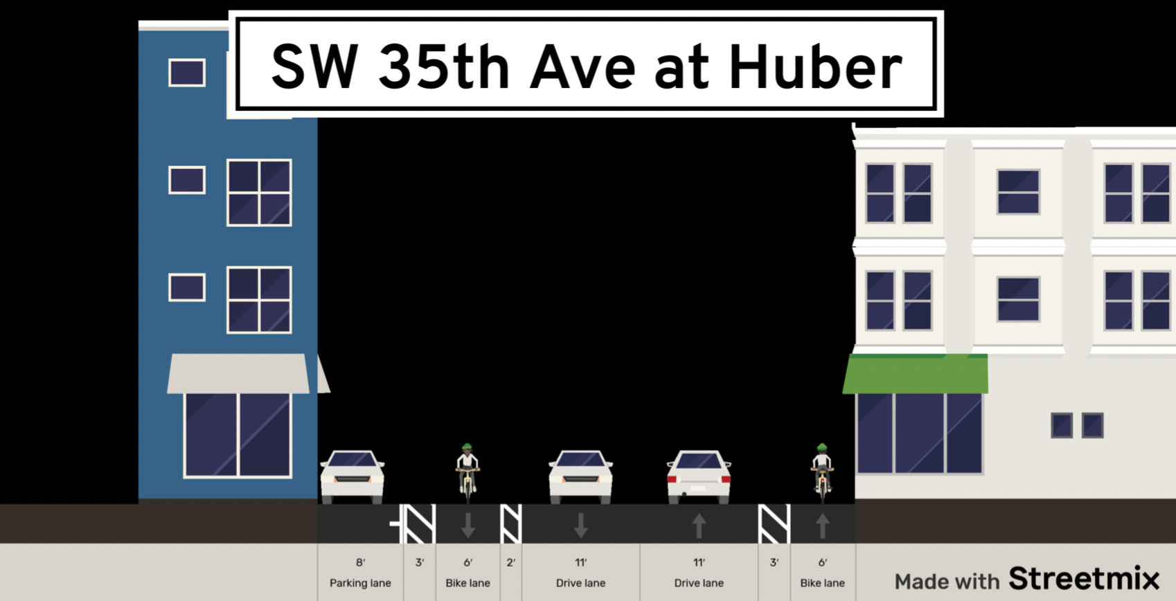
Southwest Portland is getting some new bike infrastructure. The Portland Bureau of Transportation will be completing the SW 35th Ave Bike Lane project this month, re-striping SW 35th Ave to install bike lanes from SW Ridge Drive to SW Arnold Street, as well as adding some pedestrian facilities and crosswalk upgrades.

These bike lanes, first identified in the 2030 Portland Bike Plan and then prioritized in the Southwest in Motion active transportation plan, is part of a larger strategy to make SW Portland more bike and pedestrian friendly.
As part of this SW bike plan, PBOT also plans to create a neighborhood greenway on SW Ridge Drive, which intersects with SW 35th Ave. We’ll see a new marked crosswalk with signs at the intersection of SW Ridge Drive and SW 35th Ave through this bike lane project.
Advertisement
Also included in the project is a 7-foot “safer shoulder” walkway – PBOT’s term for an interim pedestrian facility where sidewalk implementation isn’t financially feasible – starting just north of SW Ridge Drive.

This stretch of SW 35th Ave provides a crucial connection south of Barbur Blvd within SW Portland. Right now, people riding bikes on SW 35th have to share the roadway with cars, so the bike lanes will be a safer alternative. Jackson Middle School is located on this road, and these bike lanes will connect the school to surrounding neighborhoods. The TriMet stop at SW Huber St and 35th Ave will remain.
Fixing Our Streets provided funding for this project along with the SW 45th bike lane, which was completed in 2019, for $185,300 total.
PBOT says installing these bike lanes shouldn’t take long – they plan to get it done in just a weekend. In the meantime, you can find out more about this project here.


Thanks for reading.
BikePortland has served this community with independent community journalism since 2005. We rely on subscriptions from readers like you to survive. Your financial support is vital in keeping this valuable resource alive and well.
Please subscribe today to strengthen and expand our work.
I’m a bit ambivalent about it. I bike on SW 35th all the time and the parts getting bike lanes are very wide and have 25mph, so I don’t really have any issues. It’s low hanging fruit as the sketchier part just further south where it has a big up and down section, the lanes narrow, there is no shoulder… and there isn’t any upgrade. Kids still walk on that sketchy section to and from school every day. So the part that’s already pretty darn safe is getting upgraded and the unsafe part remains unsafe.
Hear, hear, fishy! You hit the nail on the head.
I bike on SW 35th all the time. The part being “upgraded” with bike lanes is already so wide that there’s never a problem sharing the lane with cars. All PBOT is doing here is adding paint markings – no other work is needed. This wide roadway is already just fine for bikes.
Seems like another performative project that allows PBOT to say they are improving conditions for cycling when in fact nothing has really changed. What we really need is for PBOT to tackle the hard project of creating room for cycling in places where there is currently no room, as they are doing right now – at great expense – on SW Capitol Hwy.
Yeah, the Capitol Hwy project looks like it’ll be great – I’m really looking forward to having an alternative to the SW 26th/SW Taylor’s Ferry junction to get across SW Barbur.
As for this project, putting in these bike lanes is pretty cheap, so maybe it’s worth it if it’ll encourage a few more neighborhood kids to bike from the Ridge neighborhood. I’m just not that excited about it since there is so much need at so many other intersections and connector streets out here in SW PDX. For example, it’d be amazing if SW Taylor’s Ferry had bike lanes that connected with SW Terwilliger, but that would be more on the scale of a Capitol Hwy project. Alas!
Good point. Also, what IS that space between the white line and the hashed buffer area? I couldn’t tell from the linked project info. It doesn’t match any of the cross-section drawings, or the striping plan.
So…paint and plastic.
Now that they’ve done it, I’m a fan. They didn’t finish over the weekend so there were lots of angry Jackson MS parents on Monday and Tuesday since it was left in a pretty confusing state, but this well definitely decrease the average speed of cars, so big win for that alone. There are big gaps in linking the SW neighborhoods, but this was a relatively cheap project and a step in the right direction.