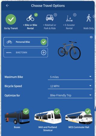
TriMet recently launched a new trip planner that is designed for use on smartphones and has some upgraded tools for people to who need help finding efficient ways to get around the Portland Metro area without their own car.
You can tell it to integrate use of e-scooters, your personal bike or Biketown without having to map everything out separately.
This is a welcome upgrade, especially as other trip planning apps like Google Maps have started including rideshare services in transit routes, adding some confusion for people who want to get around on transit without hopping into a Lyft or Uber.
I’m a devoted Google Maps user for the simple reason that I’ve been using it since I first started traveling around town on my own almost 10 years ago. Although at first I mostly used it to route me places while driving my car, I’ve also found it helpful for planning out transit routes, especially in cities I’m not super familiar with.
But when I saw a Twitter thread from Portlander (and bikey TikTok star) Jenna Phillips that she posted after Google Maps directed her to the PDX airport from North Portland with a “transit” route that included taking a Lyft for six minutes, I realized I’d been seeing this a lot lately too.
If you include hailing a rideshare as part of your transit journey, you could get from North Portland to the airport in 33 minutes, give or take traffic. But for people who want a carfree trip, Google Maps pulls a bait and switch: it would take more than an hour and multiple transfers to take the MAX or the bus.
This doesn’t just happen when going to the airport, either. As an example, I pulled up how to get from my house in the Richmond neighborhood of Portland to the Sellwood Riverfront Park. It would take 52 minutes to take the 75 and 70 buses with a 10 minute walk.
But wait! I could save a whole four minutes and the walk if I chose to take the 75 bus to Milwaukie and then call a Lyft for the rest of the trip. And it would only require me to shell out $12-14 extra on top of the $2.50 bus fare (sarcasm intended).
Google Maps didn’t suggest this, but with a little extra research I found out I could also take the 75 bus for about 30 minutes with my bike on the bus rack and then ride the 12 minutes to the park: the fastest option of all.
Advertisement
This is all to say there are various ways to mix transit to get around in ways that don’t include getting in a car, but you might need to be savvy with Google Maps to bypass their suggestions.
The TriMet trip planner, on the other hand, allows you to do a lot of helpful fine-tuning. You can input your walking speed, how far you’re willing to walk and whether to prioritize speed or fewer transfers on your journey.
Another cool feature in the new TriMet planner is how you can tell it to integrate use of e-scooters, your personal bike or Biketown without having to map everything out separately and do the addition in your head. Or you can select bike only, and see the bike route mapped out for you, changing time estimates based on your selected biking speed. TriMet even allows you to set a maximum distance you are willing to bike for the entire trip.
You can select rideshare on the TriMet planner as well, but it doesn’t do it automatically, so it’s clear what you’re signing up for when you input your location.
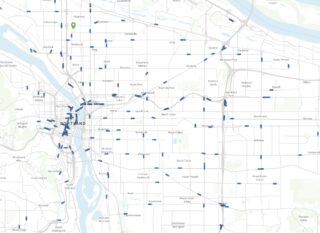
The TriMet planner is a web browser-based service, but you can add it to your phone’s home page so it effectively serves as an app. The thing I like most is seeing all the buses and trains in real time, moving around like little ants across the map. Not only does that help you figure out when your bus is coming, but it also leaves users with a sense of, “Dang, there are a lot of buses out there!” which is a subtle way to communicate high service levels, which in turn boosts confidence and ultimately encourages ridership.
I’d love to know how you usually map out your routes. Do you think there any situations where rideshare should be lumped in with transit? Let us if you’ve run into problems with Google Maps or other similar services and how you feel about TriMet’s new planner.


Thanks for reading.
BikePortland has served this community with independent community journalism since 2005. We rely on subscriptions from readers like you to survive. Your financial support is vital in keeping this valuable resource alive and well.
Please subscribe today to strengthen and expand our work.
This is very cool. I suspect I’ll be using this a lot!
This basically automates what I’ve done by hand/intuition for most of my time navigating Portland – find a bus that serves as the backbone for a longer trip, and then wing the before/after parts on my bike. As soon as there’s a transfer involved, the bus trip becomes a lot less convenient.
A huge issue with Google’s bike directions is that their bike route data doesn’t match reality. In many places, it shows bike lanes where there are none or shows nothing where bike lanes exist. This can get you sent down some odd routes.
Is the trip planner new, or did they just revamp their homepage to highlight their existing planner?
https://news.trimet.org/2019/03/trimet-tests-a-new-trip-planner-that-brings-together-transit-ridesourcing-carsharing-and-bikesharing-options/
I don’t know if the back-end of the transit planner has changed, but the interface and design is vastly different from what was there until this month.
Not bad – it doesn’t allow > 12mph for cycling speed which throws the best option out.
The fastest way from where I’m sitting to home with 10miles of cycling allowed doesn’t show because I average 16mph+
(that’s cycling 7mi to Milwaukie, hop the Orange line to OMSI, cycle to 2nd & Morrison and hop the Red Line. On a good day in good shape on one of my fast bikes I can beat it by riding right over the Sellwood bridge, up through the cemetery and up to Bvtn Hillsdale).
The route it recommends is my “lazy” route – 4mi to CTC, Green Line to connect to Red/Blue and on to Bvtn TC.
I am annoyed by google’s update too. I’m sure they are getting tons of money from lyft/uber to do this, so I’m not surprised. Thanks for sharing this website! Trimet’s old one was a little clunkier, so I appreaciate the update.
TriMet has been working on this for over a decade (around 12 years if I remember correctly). It’s certainly a technological achievement, but I wonder if it’s really the best way to spend public money and employee time.
In addition, I’d guess that the multi-modal features won’t be used by the vast majority of transit users since most people don’t and won’t commute by bike and sticking your bike on the front of the bus can be a pain. MAX is a little better but…
What if there’s no available space for your bike? Depending on your route, you might not be able to just take the next bus/train or bike the whole way. When you need to get to work on time (or a date, appointment, etc), predictability is probably more important than how long it takes.
Perhaps TriMet will publish some figures showing how much they’ve spent on this (both dollars and time) and, after a while, how many people are using the new features.
A much better use of public money would be to build a complete, connected, and safe bike network. The marginal improvements we’ve seen in the past 25ish years are rather disappointing.
And/or make the transit system a lot more bike-friendly??..!!
When ZooBomb tried to democratize the MAX for cyclists in 2002-03, TriMet’s first response was to try and ban them from riding the train (that didn’t work out the way TriMet wanted).
I’m not leaving my bike at a station if I can take it with me, and TriMet’s limits on bikes per train are pretty low, esp. if / where the service is desirable.
PS – the ZB record is 80 (mini)bikes and riders on a single-car MAX train.
I am a big fan of TriMet’s planner (for transit, bike and multimodal trips) and I think it’s a GREAT use of money. “Most people don’t/won’t commute by bike…” – for lots of reasons, but one of them is “it’s just too far” and another is “I don’t know how to get there.” This planner can resolve both issues. Combining bike and bus is a great distance-shrinker and last-mile-problem solver. Even better – you can ask for a trip plan that incorporates Biketown, solving the “no room on the bus bike rack” issue.
Yes, I agree that a complete and connected bike network would be optimal. Also, not in TriMet’s portfolio. (We got the Tilikum Crossing and Bob Stacey Bridge thanks in part to transit dollars, but don’t expect cycletracks and separated lanes.) And sure, I’m a PBOT stan but having biked in Portland for over 25 years the bikeway improvements in that time are more than “marginal.”
A truly world class bicycle bridge!
I’ve been using the new trip planner (and will be using it again today) and it’s pretty good. TriMet’s challenges do not lie on the technology front, but on the customer service front – so many bus drivers refuse to greet you as you board. It’s such a bizarre world. If I go to a grocery market, the check-out clerk will inquire how my day is going and will wish me a wonderful forever. When I board the bus, the driver is likely to look away toward the other side of the street. Sigh.
That’s interesting — it hasn’t been my experience. I always say “hello” as I board a bus, and I’d say about 80% say hello back, and maybe 20% say something more. And of course since I remind them I’m getting my bike before I get off, I’m usually engaging them as I leave too, beyond the standard “thanks.” They don’t engage me as much as a cashier at a grocery store, but the interaction is also much shorter and they’re also seeing (exponentially) more people per shift.
Max drivers are obviously a little more shut away, but sometimes they have a window open or can otherwise hear you if you say thank you as you leave.
I don’t disagree that sometimes drivers are less friendly, but having worked in service jobs before I try not to take it too personally. They have a pretty stressful work environment, all things considered.
Do you have any idea how much crap these drivers are putting up with? It is not like the old days when everyone was friendly and sane. It’s actually a wonder anyone is willing to do this thankless and stressful job.
Good overall, but I’ve found that the bike directions are sometimes routing me onto the freeway. It’s hard to make good comparisons of what mode is best to take if one of the modes is wrong.
I like the app except for you don’t seem to be able to select how far you are willing to walk. Lots of people can’t walk long distances. I just used the app and the choices it gave me had me walking 0.7 to the bus, instead of taking the Max (i am standing at a Max platform) then the bus.