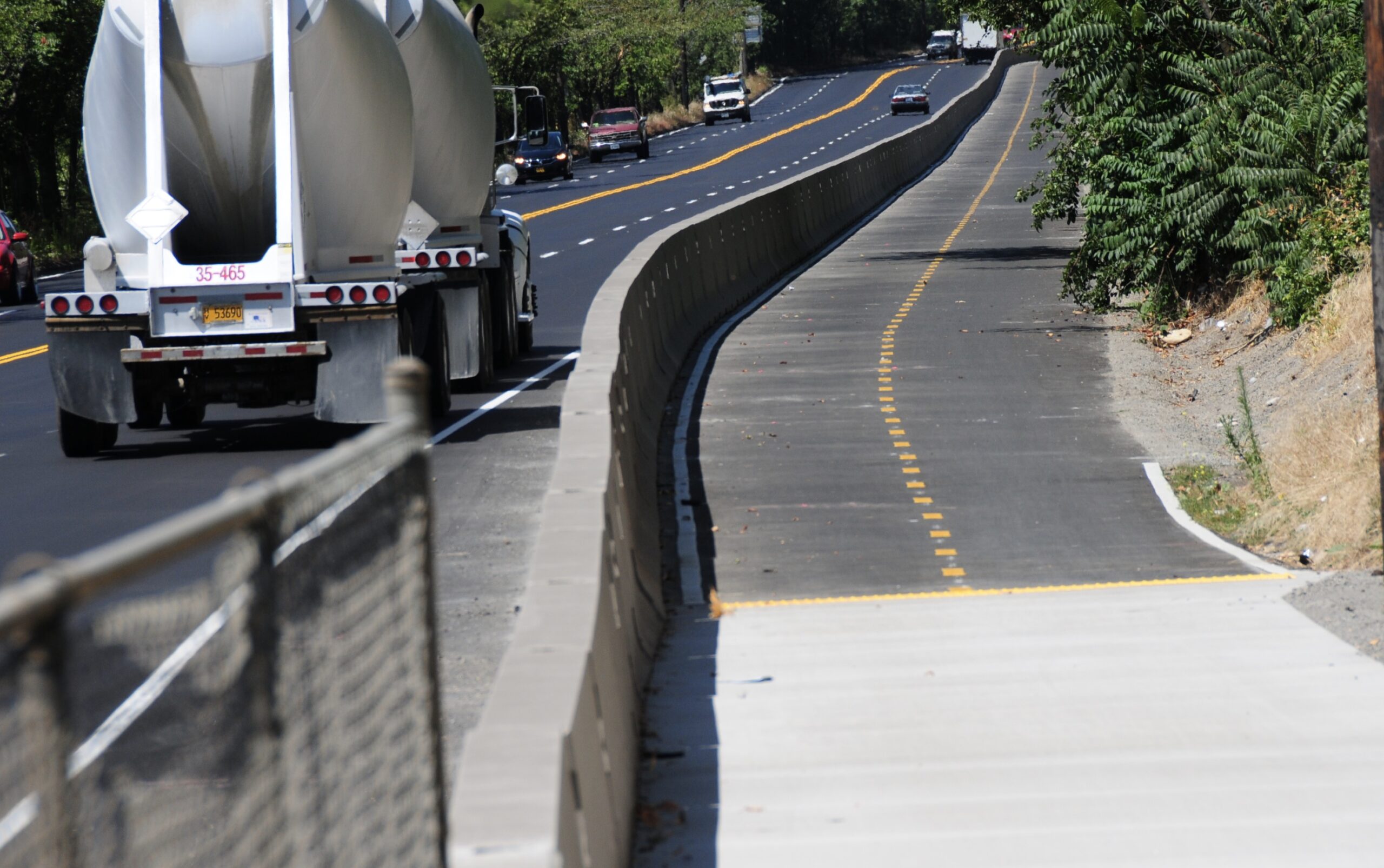
It has been a long time coming but I am happy to say that the North Greeley Avenue bike path is open. I shared a sneak peek a few weeks ago so I won’t bore you with details again, but since that post the Portland Bureau of Transportation (PBOT) has finished the striping and, more importantly, the bike signal at the north end.
But first, a few more photos of the path in all its glory (last time I was there the striping wasn’t done):


Now, about that signal. Because PBOT chose to create a two-way bike path on just one side of the road (and remove an existing bike lane from the other side) they had to figure out a way to direct southbound bicycling traffic onto the new path. This means bicycle riders have to; know how to use a bicycle-only signal, wait for it to turn green, and cross over a very wide intersection while putting their full trust in PBOT signal engineers and other road users (see third photo below).

Advertisement


To get the bike signal to work, you’ve got to wait in the right place on the sensor pad. There’s a “Stop Here” sign that points to the ground where it is. Unfortunately it’s not 100% clear where exactly to position your bike. I know what a sensor pad looks like, but not everyone does. I watched one rider wait through 3 signal cycles before he got his bike in the right place and got the green. That worries me because when people get impatient and/or don’t think signals “see” them, they will run the red. And doing that in this location could have terrible consequences.

The other thing that concerns me is the behavior of other road users. One of the times I went through on a green, a truck driver turned left onto Greeley (southbound, from westbound Going) while I was in the intersection. I’m pretty sure he wasn’t supposed to do that.
Overall the signal works like it’s supposed to, and it’s much better than the old bike lane that forced us to cross a freeway on-ramp. I’m a bit nervous however about bicycle riders crossing diagonally through a wide intersection where people drive at high speeds, there are a lot of big trucks, and where there’s a relatively low volume of bike riders (and therefore other road users aren’t expecting them). I think many people will just skip the signal and continue south without moving over to the path. As I pointed out last month, this puts them in a shared-lane environment with car users going 50+ mph.
Have you used the new signal yet? What about that path? How would rate this project on a scale of 1-10?
— Jonathan Maus: (503) 706-8804, @jonathan_maus on Twitter and jonathan@bikeportland.org
— Get our headlines delivered to your inbox.
— Support this independent community media outlet with a one-time contribution or monthly subscription.


Thanks for reading.
BikePortland has served this community with independent community journalism since 2005. We rely on subscriptions from readers like you to survive. Your financial support is vital in keeping this valuable resource alive and well.
Please subscribe today to strengthen and expand our work.
Can’t wait!
That looks really nice! That road has a lot of car-butts on that road. This is exactly the sort of protected bike lanes I want to see! 😀
Seems like some green paint with in the diagonal section would be helpful in increasing visibility, no?
I’ve rode it twice so far. The width feels good on the portion with the gravel shoulder. The part with the curb feels a bit cramped in comparison. The overgrown plants on the old concrete path to/from Interstate Ave are so far out into the path that it’s ridiculous. I saw a rider disregard the signal and continue onward with the “regular” green light. I’ll stick to the bike signal. I almost thought they did it all wrong when I stopped on the sensor and couldn’t see the signal anymore before realizing there was another on the other side of the intersection. The combination of tall, heavy barriers and fresh asphalt really help to keep the noise down from all the cars and trucks. Still not a fan of going uphill through the big intersections with lots of turning drivers.
I’m still confused why you continue to call this a bike path. PBOT itself considers it a MUP, even though it isn’t a standard MUP width. The peninsula seriously needs a way to access the rest of Portland and PBOT had a great chance here and decided to build a really big sidewalk instead. We are still missing basic connectivity to the rest of the city and this doesn’t change that.
Don’t carry water for PBOT and the freight lobbyist who told them what to build
What do you mean by “basic connectivity?”
IMO, “basic connectivity” is safe, direct and convenient. Greeley falls short of that by routing bikes out of direction, making them wait at the Greeley signal twice (at least for southbound, and underbuilt, convoluted for the southern 1/3 of the route.
A bike lane.
If you live on the peninsula, there are zero safe routes to downtown/rest of city.
So just a single safe route is what I would call “basic connectivity”
For an example, could you offer up what you think of as a “safe route” that currently exists in the city.
Licoln/Harrison Greenway, Bike lanes on Willamette, SE Ankeny from Grand to 28th, SE Clinton, NE Going east of 7th to 31st, Esplanade, Springwater…
Portland doesn’t really have any routes of significant length that I would call acceptable, but there are routes that I consider more or less safe. For example, I don’t think N Williams/ N Vancouver is well designed, but I consider it pretty safe because bikes have reached a critical mass on those streets. The concrete barriers on N. Rosa Parks are pretty good. The areas around the traffic diverters in N Portland are pretty okay. They are just islands of safety though because there are so few of them.
FWIW, PBOT itself knows what good bike infrastructure looks like. You can look at all their dusty plans, from the N Willamette Active Transportation Corridor to the North Willamette Greenway. PBOT just chooses not to build projects that are safe because it almost always has to come at a reduction in driving capacity which PBOT wont stand for.
When you said “If you live on the peninsula, there are zero safe routes to downtown/rest of city” it sounded like the rest of the city had things that N Portland does not…but now it sounds like that is not the case. Thanks for clarifying.
It is a shame PBOT has failed to meet your expectations of “acceptable.” If you keep posting comments on this blog about what a bad job they are doing… I am sure they will come around.
Ted, I know your list of accomplishments is impressive, but I think you’ve misjudged this situation!
If you reread my post a little closer and do some critical thinking, you’d realize that if you live within a reasonable catchment area of N Williams/ Vancouver, you do have safe route to the central city.
I don’t bike in SE enough to say.
In the future, read, think, then post.
5/10, the connection at the top is wonky and there are often cars parked on the lane going by Hazelnut Grove. Given that people are bringing building supplies to Hazelnut Grove, this is to be expected, but it’s kind of dumb to route a bike lane where you know people will be parking cars. Safer than the old infrastructure, but much less efficient.
Here’s a wild idea: we could enforce our city’s trespassing, camping, littering and parking laws. Maybe recover a few stolen bikes while we’re at it?
0/10 terrible take. Cops are dorks, even the unpaid ones posting on internet forums.
Hazelnut Grove will soon be no more. It’s all being moved to the center of the St Johns community. The camp will be next to homes, several schools, and the library. St Johns will have, by far, the highest percentage of low income housing in the Metro region. The people of Overlook have spoke!
Missed opportunity to show a picture of the signal pad on each side and where one should place their bike for maximum effect.
Jonathan,
Your last photo shows a green bike signal at the same time there is a southbound green left turn signal. Two vehicle paths that do not overlap are generally accepted as movements that can occur at the same time.
There are not sensor pads. Induction loops are wires in the road that detect a disturbance in the magnetic field of the earth when metal passes over. Request the loops be marked with the bike symbol on the pavement. It is perhaps an item not yet completed.
I’m trying to understand how this excessively pedantic commentary is supposed to be helpful. Most people will call it a “sensor” or “sensor pad” or something to that effect (and it is a sensor). How it’s implemented, however technically interesting, is really irrelevant, or at least it should be. The only thing that matters is that it’s located in the right place, it’s marked, and that it works.
It could be paved in gold and have Benson bubblers every 100 yards, and people would still complain.
Benson Bidets?
I like your style.
I would definitely complain.
Gold would be slick (especially in the wet) and the Benson bubblers would be a hazard as well as a nuisance since they’d encourage people to stop and block the path.
Gold would be impractical as a pavement for incalculable reasons, not the least of which is that it would be slippery dry or wet; bubblers every hundred yards would be an enormous waste of resources, and depending how far off the path they are, could be potentially dangerous, so, yes, there would definitely be complaints if gold and bubblers were part of the infrastructure.
And no matter what people do or don’t say, you will generally have a negative comment about it.
Rode it the other day and it is great. Now if we could only do something about Interstate!
My kids have commented when we’ve been driving down Greeley, “Wow! look what they did here. That looks so much safer!”
I haven’t ridden it yet, but I’ll just say that any cycling “improvement” that requires cyclists to stop and wait in a fixed (hard to see) location on the pavement for a signal that stops all motorized traffic and then proceed on faith that said traffic will remain stopped is, well, kind of a loser from the outset.
Designers of MV infrastructure are obsessed with “flow” – moving cars and trucks steadily and efficiently, with a minimum number of stops (exactly what the new, unimpeded Greeley Speedway accomplishes for cars and freight). But the designers of cycling infrastructure in Portland are obsessed with STOPPING bikes and cars and trucks so that cyclists can proceed when cars and trucks are stopped, and vice versa. AND complete stops on a bike kill all momentum and efficiency of our mode of travel, not to mention the joy of riding a bike.
I actually liked the former configuration, except for the Going-to-Greeley onramp and the I-5 offramp, but those dangers could have been managed individually by installing crossing-warning lights, similar to what we see around Portland on busy streets. But PBOT caved to the freight interests by banning bikes to their own little alley. It’s a win for cars and trucks and freight haulers, not for cyclists. We’re left with a turd to polish.
This is the logical outcome of insisting on full separation in an environment where people must cross each others’ paths frequently.
You don’t have to ride in it. It’s not a “mandatory side-path” bike lane. You can legally take the big lane.
There used to be a nice wide shoulder on the southbound side of Greeley that allowed bicyclists to avoid having to take the lane in the face of semi trucks towing triple trailers at freeway speeds. The shoulder has been completely eliminated, making riding outside of the new mup tantamount to suicide.
I have concerns about how ORS 814.420 would apply in that situation, and I’m quite sure I would not want to test such case as a bicyclist, especially in front of Judge Zusman.
I often don’t take lanes and have been doing it my whole life.
This is not worth worrying about. At worst, you’ll get yelled at once in a long while.
I agree with your framing, Kyle, but still disagree with Johnny’s. Consider a bicyclist (or their estate) trying to collect after a collision on the southbound side.
I would give this a 2 out of 10. For 2/3’s of the route, the bike lanes appear to be a great piece of protected infrastructure, but if you look closer you see what a failure the project is. The connections at either end are severely lacking. The final 1/3 of the route is along a sidewalk that is less than 10 feet wide, is currently permitted and sanctioned by the City to be used as a driveway for personal vehicles and used regularly by service vehicles to provide water, service portable toilets and remove trash. The temporary fence for Hazelnut Grove is installed ON the path, reducing its width and adding dangerous obstacles.The route southbound is not longer and far less convenient since you have to wait at a signal to cross Greeley at Going, then again at the intersection with Interstate.There is no space for pedestrians, even though this is called a MUP. The facility is too narrow for speed differential of the directional bike lanes- IF this was not so poorly connected it would get a lot of use and this would be a problem, but since the connections are so poor, it unlikely to get enough use for the undersized design to become a problem. The connection to Interstate involves riding on the only sidewalk along Interstate, making a quick series of quick hard right turns in alternating directions including on to and down a single ramp used by 2-way bike traffic.At the bottom of this ramp, bikes heading south have to make an immediate 90-degree right turn and merge into a 5′ wide bike lane adjacent to motor vehicle lane at the bottom of a hill (so high speeds for oncoming bikes, cars and trucks)without a single sign or any paint. Despite fundamentally changing how this sidewalk is being used, PBOT did not make a single improvement- no signage, no striping, no brush clearing or limbing trees, nothing to prevent the continued use as a driveway- this remains a very dangerous series of conflicts. Maybe 2 out of 10 is generous?
Your photos omit all the parts of this ‘mup’ that are problem areas. No pictures of the unregistered and likely stolen cars and trucks that are parked on or around the path, which is technically closed to motor vehicles. No pictures of overgrown vegetation that impedes the path. No pictures of human waste that has frequently been spilled from containers in the camp and which has flowed into the path. No pictures of utility poles that would continue to constrict the path, even if the vegetation was to be trimmed.
The areas that you highlighted look great, with the exception of the crossover.
I did consider adding a photo of the overgrown vegetation on the part of the path near Hazelnut Grove, but I decided against it. With everything going on in the world, calling out PBOT for not trimming some bushes just didn’t feel right. The issue does concern me though and you can rest assured it’s on my radar.
Here’s that photo of the overgrowth…

Thanks, Jonathan. I do understand that you are trying to highlight the installation of what is really some of the best and safest bike infrastructure in the city, in terms of its design.
The completion date for a brand new piece of “platinum” bike infrastructure seems like a really good time to send a crew out for 15 minutes to trim vegetation on the required connecting trail.
Or you could DIY, as others have around town. Maybe create a “Friends of the Going Street MUP” organization?
My Interstate hill descent times on Strava are now unbeatable forever, mwahahahaha!
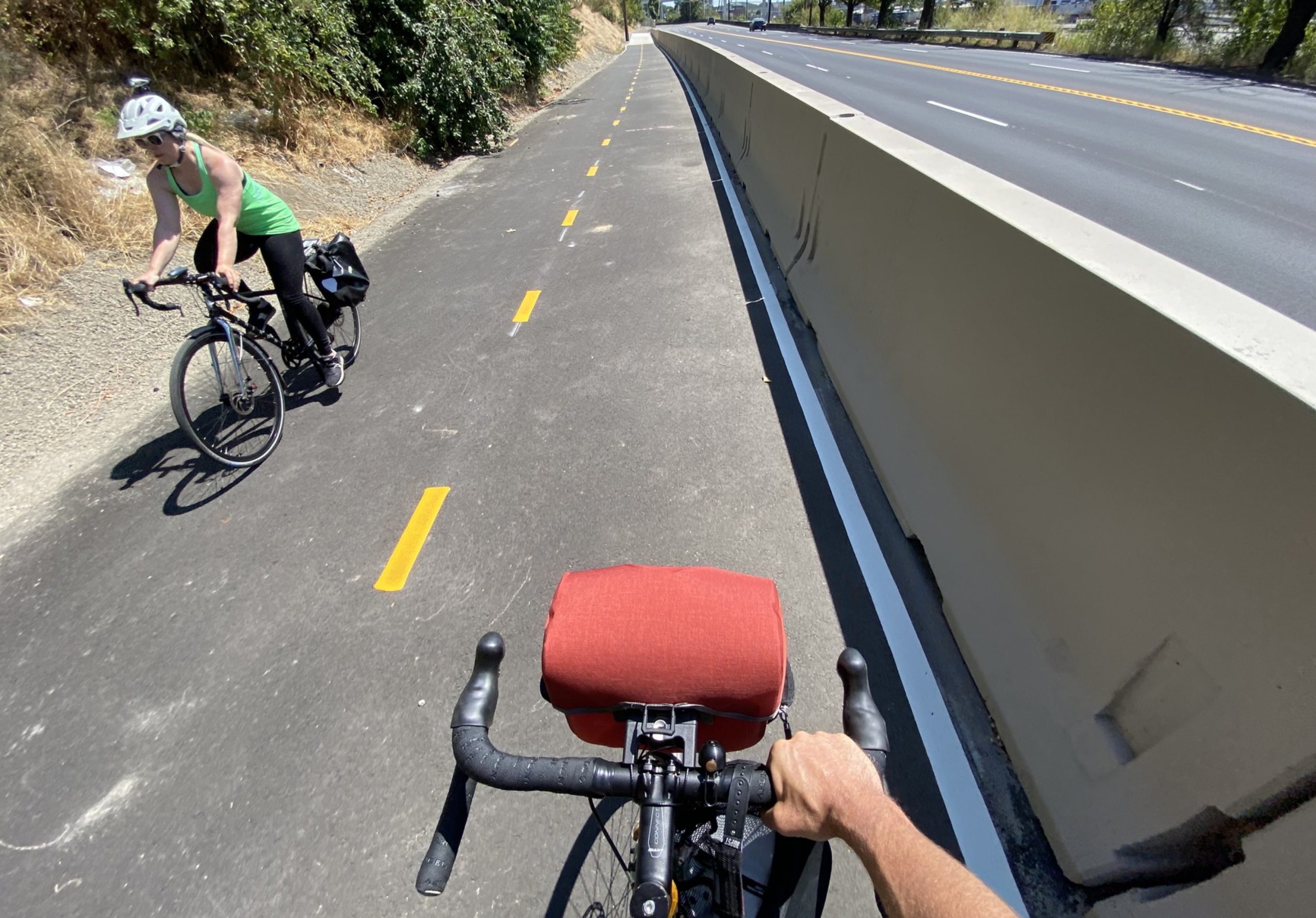
What kind of bag is that mounted to the handlebars in the picture labeled “The guantlet?”
Ortlieb handlebar bag. Just started using it. Fits my DSLR camera perfectly!
I would give this 0/10 from a driving perspective. The median driving speeds before the project were over 55 mph in each direction. A woman and her daughter were killed in their van due to dangerous driving at high speeds. This occurred while there was plenty of time to revisit this design to consider lower speeds, few lanes, a traffic signal at the on-ramp, making the driving lanes more narrow, or basically any consideration of safety during the design. I asked tehm to consider this road from a Vision Zero perspective and was told they would not. In fact, the project removed bikes AND WIDENED lanes which will likely increase driving speeds. PBOT took a fast and deadly street, and redesigned it to be faster for the express purpose of satisfying freight, and in the face of community members asking for lower speeds. The bike infrastructure is really bad, but the driving infrastructure is totally crazy.
Another clear effort that civic engineers do not commute by bike. These signals are such a headache for most people. You would be better off adopting a water like riding style and learn to weave thru traffic. Alas, keep trying better signal alignment and foresee lane building that does not require what seems like 6 lanes to make it across to the next lane.
npGreenway (aka Friends of the North Portland Willamette Greenway Trail) continues to promote its vision of a water level and even River side paved multi-use trail from Kelley Point Park to the Esplanade. Learn more at npGreenway.org
The Greeley cycle track/sidewalk, while useful as a safer bike/ped facility, is not the Willamette Greenway Trail! We continue to believe that the day will come when a second access road to Swan Island is secured in public ownership, and what is now called the Ash Grove Cement Road will be refitted with a 14′ wide true multi-use trail. Meanwhile, its a lovely ride…but watch out for the track crossings and wave to the UPRR crews!
We are now awaiting PBOT’s estimate for the Swan Island segment from the exiting Trail at N. Lagoon Avenue and Ballast to the Waud Bluff Trail. Univ. of Portland is building a section of Trail on its River campus with a new RR crossing at Van Houten. Metro is committed to a full clean up of its Willamette Cove property with provision for the Trail and full public access to the River. And last, but not least, Metro is leading the Columbia Blvd. Bridge/St Johns Prairie project between Chimney Park and a viewpoint in the old landfill. So stuff is happening!
How can we make faster progress? Join npGreenway! get on our email list and show up when trail funding decisions are on the agenda. Write to your electeds at City Council, Metro and Multnomah county; remind Rep. Blumenauer of our need for climate friendly capital investment. Just insist at every opportunity that this Trail get built!! Help create a wave…politicians will all jump on for the ride.
Thanks for your advocacy Lenny. I’ve been waiting for (and riding on) the npGreenway most of my life.
I’m excited to see a new protected bike facility. Unfortunately, in-ground bicycle sensors will NEVER detect a person on a skateboard. I don’t understand why PBOT insists on using sensor tech that doesn’t work well with bikes, let alone other road users.
I rode up it and liked the separation and the new pavement markings between Going and Willamette. I haven’t gone down and tried the new crossing, but overall the implementation seems practical and effective when it comes to separating cyclists from motor vehicles along the most vulnerable section of Greeley. One concern is that some will continue to blast downhill even though they are now in a corral with uphill users, but that’s a safety and etiquette issue that applies to any MUP.
Asher, your “one concern” IS THE FATAL FLAW OF THE DESIGN. PBOT absolutely should have designed a path to accommodate people riding down the hill, since it is on a hill! IMO, people are evaluating this path by its cross-section and ignoring its context. It is too narrow for the speed differential, it does not provide space for pedestrians, and the southern connection has such tight geometry that it will not work well for many vehicles (tandems, bikes with trailers, etc).
I’ve ridden it a dozen or so times now. The signal is weird, yes. My steel bike with carbon wheels doesn’t even set those things off. But basically the bike signal corresponds to the left turn signal for southbound traffic on greeley, so when that arrow comes on I go.
What I find more troubling, and which doesn’t seem to be part of the plan if this project is indeed finished, is way-finding to the entrance at the south end of the corridor. It’s far too easy to make one wrong turn and end up in the traffic lanes, crawling up the hill with no shoulder and no way out other than climbing the wall. I’ve seen it happen a couple of times already and almost did it myself once. This could be fixed with paint but hasn’t been.
Many advocates hate “beg buttons” but having one here would be a good redundancy for those with carbon bikes or those who dont know about the sensor loops.
I’m curious about the status of the diagonal crosswalk from a legal perspective. It’s interesting that it’s not painted as an actual crosswalk, or a “green” crosswalk. While I’m not a lawyer, my understanding is that the white borders on green bike crosswalks have legal ramifications.
If this is indeed a MUP, it seems to me that this should be a legal crosswalk, but its hard to tell what its status is by its current configuration.