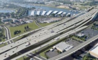
While all the attention at today’s Oregon Transportation Commission (OTC) meeting will be on the I-5 Rose Quarter Project, there’s another highway expansion mega-project that will take an important step forward.
The OTC is expected to give the Oregon Department of Transportation permission to enter into an intergovernmental agreement (IGA) with the Washington Department of Transportation that will lay the groundwork for cooperation on a project to replace the I-5 bridges over the Columbia River. This is a resurrection of the ill-fated Columbia River Crossing (CRC) project that came crashing down in 2013 after the Washington legislature backed out of their funding commitments.
But since massive highway expansion projects are the air that keep state transportation agencies alive, after spending eight years and over $200 million the first time around, Oregon and Washington are eager to try again.
The IGA on today’s OTC’s agenda (PDF) outlines the roles and responsibilities of both state DOTs — from handling contractors to how to respond to public records requests. Most importantly, the agreement commits Oregon to 50% of the project planning and developments costs. Oregon has already spent $9 million on this project to help fill a funding pot with $35 million from Washington. Both states are working together to create a new project office and to hire a program administrator that will work for both DOTs.
Advertisement
The bridge replacement and highway expansion has already made its way into the local politics. At a mayoral candidate debate on March 8th, Portland Mayor Ted Wheeler responded to a question about the I-5 Rose Quarter project by saying, “Then we have to talk about I-5 going over the Columbia River. We can’t just let it fall into the river. At some point we’re going to have to invest in that infrastructure as well.”
And interest groups are wasting no time rallying troops.
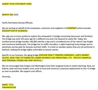
On March 11th, the Columbia Corridor Association, a nonprofit business association that represents an industrial district on the Oregon side of the river, sent an “urgent request” to its members. Urged on by Vancouver Mayor Anne McEnerny-Ogle, CCA leader Corky Collier wanted to drum up as many support letters from business owners as he could and send them to Oregon House Representative Peter DeFazio before he entered into infrastructure funding talks on Capitol Hill. “We have a short window to make a difference,” Collier wrote in the email. “We have a golden opportunity to have a powerful impact on the most important House member for transportation.”
The CCA included a form letter that read (in part), “We urge you to move quickly to replace the antiquated I-5 bridge… Today, the accident-prone bridge handles 140,000 vehicles a day and is considered one of the nation’s top freight and commerce bottlenecks.”
Last time around, the fight against this project was long and bruising. Given the intensity of the climate change movement (which was nowhere near as potent 10 years ago), the controversy surrounding the nearby I-5 Rose Quarter project, and continued lack of trust in ODOT, there’s no reason to assume things will be any smoother this time.
— Jonathan Maus: (503) 706-8804, @jonathan_maus on Twitter and jonathan@bikeportland.org
— Get our headlines delivered to your inbox.
— Support this independent community media outlet with a one-time contribution or monthly subscription.


Thanks for reading.
BikePortland has served this community with independent community journalism since 2005. We rely on subscriptions from readers like you to survive. Your financial support is vital in keeping this valuable resource alive and well.
Please subscribe today to strengthen and expand our work.
CRC 2.0, now “I-5 Bridge Replacement,” would be a huge disaster for Vancouver. In order to accomodate large ships the required USCG clearance is 135 ft. The Marquam bridge has 130 ft. so that is probably similar to what would be needed. They could go with a one level bridge, but since this is serving the main interstate route I would think they would plan on eventually 5 lanes in each direction—a very wide, and vulnerable structure. Try to imagine getting up to that height from the Oregon side; and there would be numerous ramps on the Washington side that would have to be connected.
This would also increase the input of surface traffic into Portland as the region grows and as both Washington and California continue to ship products through here. Even widening of the Rose Quarter would eventually not be enough to handle the increased traffic. US 26 to Beaverton and Hillsboro would also turn into a hopelessly crowded route, far worse than it presently is.
Is that what the transportation models show based on a proposed design or is that an opinion?
The models don’t factor in surface street diversions.
It doesn’t take a genius to understand what will happen when you remove the bottleneck at the river. The bottleneck will move south, into the 6-lane section in North Portland. This will drive significant amounts of traffic onto surface streets like Interstate, MLK, Vancouver/Williams, etc.
At what point does it become better/cheaper/more feasible to build the crc as a tunnel, under the river?
It works fine for the greater Vancouver, B.C. region.
https://en.m.wikipedia.org/wiki/George_Massey_Tunnel
You could fit 3-4 lanes, each way, a MAX line, and bike/ped path (would need to be fully enclosed with a dedicated air handler)
So we could have a tailwind through this tunnel?
Well, obviously yes
I mean, you act like models aren’t just automated collections of opinions expressed as math.
Step one: groom your data.
I propose a “Tom McCall Memorial Columbia River Crossing:” one lane northbound.
I wonder if they’re going to push the same overpriced, overbuilt mega-project as last time, or if they’ll consider any of the smaller, smarter, more affordable alternatives presented by CRC opponents during the previous debacle.
Given the way ODOT works, they’ll probably just resurrect the mega-project and keep pretending better alternatives don’t exist.
I’m a huge ODOT skeptic and critic… But I actually think in the end they want a project and they know if they don’t scale it down considerably and do a lot less freeway expansion they won’t have a project. So yes, I think the designs this time around will be much different and much better for bike/walk/transit. Look at I-5 Rose Quarter as an example. They’ve wanted that for decades and it started as a massive disgusting freeway widening and was whittled down over time to the current design… which I still don’t support but is absolutely much better than what had been previously proposed.
But keep in mind, this is how DOTs work. They always assume as a default that a widening/expansion is necessary… Instead of questioning whether or not we need it at all.
The funding formulas for most (all?) state DOTs and the USDOT is based on either maintenance of existing capacity or adding more capacity – you get more money by expanding lane capacity; if you don’t expand, you get less money. And if you remove capacity, you get no money. Which is why you only see highways grow in the US, never shrink. The Tom McCall park only worked because they expanded capacity of I-5 on the other side of the river.
This reads as absolute insanity in The Before-Times. But now it seems utterly surreal fantasy. That bridge may have carried 140,000 vehicles a day once, but it will not carry anywhere near that number after Great Depression 2.0.
But there will be eventual growth again and money is cheap right now. Big infra projects are good to do during a depression.
Interest rates are low, but construction costs are still outrageous. If we build anything now, it shouldn’t be something that doubles-down on fossil fuel transportation. This will be in place for the next 50-100 years.
“Today, the accident-prone bridge handles 140,000 vehicles a day and is considered one of the nation’s top freight and commerce bottlenecks.”
I doubt that is an accurate description of *today* more likely some other day. Tolling will reveal how much of traffic is discretionary. Then we can skip the expansion altogether.
#donothingalternative
The thing about the ‘do nothing’ approach is that the bridge is still old and not seismically sound. Doing nothing means it falls into the river in an earthquake. If you don’t want an added capacity, then advocate for a seismically sound copy of the old bridge. Personally, I’d like to see a bridge that has increased bike and ped capacity, as well as light rail. I would also like to see a wide outside shoulder that could be used for transit (bus on shoulder) and for breakdowns.
I agree with you, and hinted at this in my comment. I suggested skipping the *expansion*.
An earthquake resilient bridge made for people not cheap fossil fuels could be a salutary thing.
I remember attending numerous CRC meetings. The I-5 bridge not being earthquake resistant was a false narrative – it will likely hold up fine, in fact it’s overbuilt, and has already survived several earthquakes in its 100+ years of being around. Apparently the cost of upgrading it to survive a 9.5 earthquake is under $100 million, far less than even a modest CRC. The main complaint about it is that it is old and (for people who don’t like it) ugly. And that traffic has to come to a complete stop every time a ship passes through (heaven forbid!)
The main point of the CRC is to spend gobs of federal dollars we don’t have on a project we don’t need of a bland design that no one wants.
David: Historically speaking, you are inaccurate. Harbor Drive was a state highway, not a federal freeway. Could just take it out, which we did.
And about earthquakes. Every bridge on the Columbia and the Willamette is coming down in the Big One, the Cascadia Subduction Zone Quake and Tsunami, or will be impaired on the ramps and become un-usable (Sellwood and Tillikum and Glenn Jackson).
I think Boulanger is just wrong — that if ODOT and WADOT try to just go forward with the old plan to bring the federal money in, the project will fail to be built with all its ramps and interchanges at the 115 or 95 foot heights that were considered. I expect that to happen.
I also predict that the City Council with its new members and Mayor will stop the Rose Quarter Project with its classic bait and switch ODOT is pulling on the Albina Vision folk.
Make ’em find money to run a Portland-Vancouver Amtrak commuter mini-route. I have contacted my WA legislators about this.
VAN-PDX Amtrak Commuter Train Service: this is a great idea, but one that has two main short falls,
1) BSNF owns the 1910 river crossings and they do not want to make any design upgrades to these structures (so a new heavy rail crossing needs to be built) and
2) there is very little “spare” capacity (both track access and now Amtrak Cascade carriages post derailment / FRA safety changes / new train manufacturing bottlenecks starting to occur)
One aspect of the CRC1 bridge design that came out to the “public” very late in the last process was the ultimate bridge height…go out and look at the existing bridge and imagine the base of the a future bridge being as tall as the tippy top of the existing bridge.
This project in some form is going to happen – especially now with Congress & Trump ready to do infrastructure – the BEST thing that Portlanders can do for this project overall is to make sure that MAX crosses the river (not swapped out by CTRAN BRT that can easily disappear) AND that this is a true limited access highway (NO ramps to Hayden Island and no GP ramps to Downtown Vancouver south of Mill Plain [SR14 is ok]). These fewer ramps will allow for a much more gradual slope and help with bike access and more flexible route alignment. Note: Hayden Island will repurpose a portion of the existing I-5 infrastructure to gain motor vehicle access to “mainland” Portland.
Trump has talked about infrastructure for the past 4 years. The Rs had all branches of government controlled for two of the 4. If they wanted to do infrastructure, they would have done it already.
todd.boulanger – You have that backward. The CRC height, when released to the public, was 95 feet and they were pushing the design to get it to 115 feet. (The core of engineers dredge needed 116 feet of clearance) The existing lift is 174 feet.
That was part of the push against the CRC is that the existing industry needs the 174′ clearance.
https://www.opb.org/news/article/height-proposed-crc-bridge-could-be-problematic/
If WSDoT & ODoT can find the political will and internal resources (& on-call) then they will likely consider the CRC1 plans “on the shelf” and “shovel ready” and thus able to get into the Federal $$$ early.
The question is: “design wise” is there enough “good” in the CRC1 to move forward with minor tweeks (dropping ramps etc. and other modern updates) so that the FEIS does not have to restart the public process?!
This CV19 “emergency period” may cause the feds to lower the amount of local match required (to 10% or even 0% vs. increasing it to 60%, as I once thought would happen during “Trump1”) for a short period just to get things done since local legislatures cannot meet for new budget deals and everyone wants to have a election eve “win”. My worry is I hope the FTA still has funds to do the MAX portion (it was the lack of the highway match that killed the CRC1).
Note the politically expedient timing of announcements for megaprojects like these while unemployment is surging and borrowing is cheap. It doesn’t matter that the jobs will come too late and our fiscal situation is… unprintable on BikePortland. Our leaders are doing something!
The highway lobby isn’t letting a good crisis go to waste, but Chloe Eudaly is.
Perhaps our officials should consider another (that you list above)official’s recent comment of “now is not the time for hastily executed street changes.”
These clowns have the same ability to predict and act on future events that the folks who decided to not stockpile N95 masks and ship production out of the country did. They think traffic volumes will continue to grow even after Covid-90 has pricked the bubble created by a 40 year debt and credit-creation super cycle. As bad as the effects of the virus are, it is just the black swan that is kicking off what was going to happen anyway. We entered a new era in 2020 and it will not involve growing volumes of car and truck traffic.
I was thinking about the impediments in the 1.0 version and was wondering what has changed in a decade. Has Vancouver changed its mind about the MAX? Is Pearson Field’s approach path still a problem for some bridge designs? Do the projections about the amount of traffic over the bridge still hold weight? Will the new project be more limited in scope to avoid redesigning access to Hayden Island and Marine Drive?
The CoV (as owner) and the “less than 100” powerful users of this public [air] park are not likely to budge on closing Peirson for any new bridge…as the City would not do it to support 2x/ 3x taller buildings along the new Waterfront community.
City of Vancouver was generally in favor of MAX. The county was opposed. The county has changed its governing structure, but the general position may still hold (dunno). Keep in mind that it was the county’s opposition, based on MAX and the budget, that turned Washington against the CRC, so the political calculus involving MAX is mixed.
Start a $5 one way toll southbound today (this is about the same as I remember paying in 1962…$.20 each way or $.40 x inflation). Stripe a Free HOV/transit lane each way (OK for freight in off hours). Put the money into a seismic retrofit account. The bridges are anchored on good old Doug Fir pilings, which being totally submerged are as good as new! Move on to addressing the real 21st century infrastructure issue: decommissioning urban freeways.
Maybe we can just outlaw OR employers hiring people from WA.
https://en.wikipedia.org/wiki/Straw_man
Middle-of-the-Road-Guy: I think this is a great idea (but for companies in both states)…I think someone previously had suggested a similar but “fairer” [more middle of the road type plan] (and constitutionally secure) option of making it a program where there was a ~6 month transition plan for new employees to transfer to their new “home work state”. There would likely be tax breaks vs. fines…perhaps funded through gas taxes (saved for not enlargening roadway capacity)…and perhaps allowance for those who take transit or bike etc.
I think the issue is that the pilings aren’t anchored to bedrock. The concern is that a major earthquake or a large one centered near Portland could cause liquefaction and destabilize the structure.
Another issue is that the bridge opening is narrow. Could the pilings be retrofitted without narrowing the channel further?
Even new pilings won’t reach bedrock, but they would extend below the liquefaction zone. They would improve the seismic capability to current standards.
The bridge opening problem has to do with the misalignment of the higher, wider center span of the I-5 bridge with the swing span opening of the BNSF train bridge close downstream. It’s a dicey move for barges to try to make that S-turn, so they’re safer using the I-5 draw span which stops traffic.
The Common Sense Alternative from 2011 addresses all that and more: https://youtu.be/sPB1jtmHVkk (Cheaper! Faster! Better!)
The Cascadian Subduction zone is located on the continental shelf—about 120 miles west of here (or more). If you live in Brookings or Port Orford it is more like 30 miles, and geologists seem to think that area is more active, anyway. The FHWA does have numerous guidelines and publications for retrofitting the ubiquitous truss style bridges. I worked in some seismic upgrade and I think the I-5 bridges are worth retrofitting. The main concern would be liquefaction during a prolonged quake. California has been dealing with these very same issues and now has extensive knowledge. PEER lab at UC Berkeley has emerged as a leading expert in seismic protection.
Question for you: Do you have any notion of how well-built tunnels (as in the George Massy under the Frasure river in Delta BC that Ken S refers to above) and floating bridges (I-90 & SR520 in Seattle across Lake Washington) hold up in major earthquakes versus bridges?
David Hampsten, 1. What we found in seismic upgrading is that, on occasion, the engineering doesn’t actually perform in real world conditions. Also, having worked in the trade that specializes in reinforced concrete, I would take steel over it any day. The new Network Tied Arch bridge type (Waldport has one) is very low mass so the basic steel components should hold up very well, especially compared to a high mass concrete structure. Remember the FIGG Engineering concrete bridge collapse in Florida last summer? Enough said. Hopefully this female owned ‘minority contractor’ is out of the running for any Columbia River bridge.
2. I’m not sure how you would repair a concrete tunnel that is underground and also under 40 ft. of water. I guess the answer is “very carefully.”
3. Seattle Tunnel Partners still shows up at discussions of a Columbia River crossing, even though the Interstate 5 Committee has ruled out tunnels. What they don’t say—and they only said to me because I asked—is that their estimates are about $5 billion. Or were 3 years ago. In the east there have now been a number of Network Tied Arch bridges (google that) and all have been under $150 million. Our needs are much greater and we need to span Port areas, too, so I’m thinking more like $500 million. Everyone else will disagree, but look at the actual record.
Ron Buel, There is not a lot of common sense in expanding capacity in the I-5 corridor, and then imposing tolling because it doesn’t really work and we are stuck with the cost, anyway. What has been happening since 1990 is that this area has developed a major new commuting route—Clark Co. to Washington Co. The freight capacity on I-5 is fine; it’s the commuters that are causing the overload. We need to solve this commuting problem since ODOT is slated to deal with the issue of the SW Quadrant of the inner freeway loop at some point coming up in the future, whenever they finish analyzing the SE Quadrant. My motto: A shortcut benefits all modes.
Lastly, everyone, please stop saying that bridges will “fall down.” The CSZ is 120+ miles from here, and yes bridges could be harmed, but most likely is that they would just sink, if anything. We might need to drive deeper, stronger pilings alongside; but that can be done.
Time to look at this again?
https://www.youtube.com/watch?v=sPB1jtmHVkk
GMTA! 😀
Looking again at the Common Sense Alternative, I noticed that at some middle stage the Hayden Island ramps on the Washington side are dropped. Why not do that first? I’ve suggested buying out the big box stores but it would be ok if the old Invisible Hand flicks them off the map. If I-5 is there primarily to move freight and border-to-border traffic why are we fostering a retail tax haven and a clutch of lottery casinos?
The resulting improvement in traffic flow would clear up a lot of fuzzy thinking.
MOAR BRIDGEZ!!!
Seriously though, that would be awesome;
more options for crossings, dedicated surface street connectors, transit, better freight access, less freeway expansion, AND it creates jobs for longer, due to multiple project stages!
What’s not to love?*
*The ‘powers that be’ didn’t think of it, so it’s evil and the idea must be stamped out
Here’s a wacky idea: what if we did just take the risk that it falls down in an earthquake? It’s pretty unlikely to hapen, and if it did, then….so? I get it, it’d be a disruption and it’d take years to replace. But 205 is a few miles away, and the entire region would be rebuilding for those same years, it’s not like life would otherwise be normal. Is the small possibility of going without really worth billions?
I Gov Inslee on board with this? Any chance he could throw a wrench into the works?
Jim Howell, with help from George Crandall, has re-designed the Common Sense Alternative as an eight-lane bridge alongside the current bridges (to the East) and not replacing the current bridges but using them for transit, bikes and local vehicles. This eight-lane bridge has a bascule opening that allows ship passage in line with the existing opening in the existing bridges. This would be a low bridge, and with fixes to the railroad bridge, would eliminate 90% of the current openings. Cost would be under $1 billion, and you wouldn’t need the massively expensive interchanges previously designed for the CRC. This is a bridge environmentalists could support and it would not induce demand. You could finance it without tolls because the tolls should be on the whole freeway system. No huge increase in traffic, so no huge increase in greenhouse gas emissions.