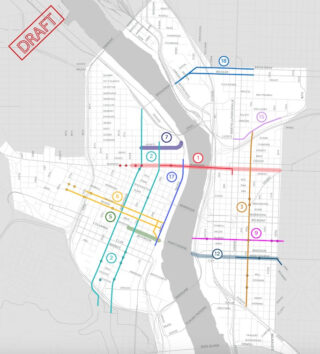
One week after an open house where the public was asked to rank a list of potential projects to be funded through the Central City in Motion plan, the Portland Bureau of Transportation has trimmed the list from 18 to 11. PBOT also seems to have axed key parts of two remaining projects.
At least that’s how it appears in an email just sent to members of a local, pro-business advocacy group.
Business for a Better Portland (BBPDX) sent an email to members today encouraging them to submit comments on the projects. “Although the online open house survey is now closed,” reads the email, “BBPDX members have the opportunity to provide direct feedback on which projects should be slated for development in the next five years.”
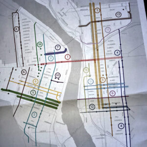
The map and list of projects provided by BBPDX is different than the map shown at the open house last week. The most recent map made public by PBOT showed 18 “project bundles” (a mix of protected bike lanes, crossing updates, and enhanced transit lanes). The map revealed in the email from BBPDX today shows just 11 projects — two of which have had key elements removed since last week.
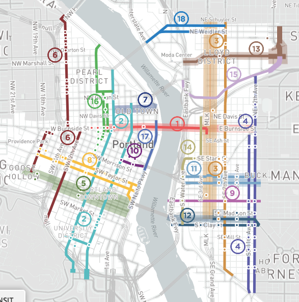
PBOT has $9 million already dedicated to the projects and expects a total budget of $30 million. The agency is making its final efforts to garner feedback and come up with a list of “transformative” projects that can be built right away (which likely means spring/summer 2019 when construction season begins again and the requisite engineering and design work can be completed).
Here are the six projects BBPDX says have been removed from consideration (and their estimated cost, based on a mid-level build quality):
4) NE/SE 11th / 12th: $7,800,000
“11th and 12th Avenues are an important north-south route for freight, transit, autos and people biking. Today the roadways feature two narrow travel lanes that don’t accommodate trucks or buses well. They are also difficult to cross. The project would redesign the roadways to include one wider travel lane to better accommodate buses and trucks, a buffered bike lane, parking, and a series of pedestrian crossing and bus stop improvements.”
6) NW/SW 12th / 14th / 17th: $3,030,000
“These streets work together to provide access to and from the Pearl District and through Goose Hollow. NW 14th would create a protected bicycle lane from Burnside to Hoyt, and a wide bicycle lane from Hoyt to Savier. Improvements to SW 17th Avenue would create a protected two-way, cycle track from Salmon to Alder, and a neighborhood greenway from Madison to I-405. A protected bicycle facility on SW 12th from College to Stark would provide access to the west side of the PSU campus.”
Advertisement
10) SW Alder / Washington: $1,400,000
“The Morrison bridge has a wonderful existing walking and biking path, but access to it poor. This project would improve pedestrian access and safety by eliminating dual turn lanes approaching the bridge. A short segment of two-way protected cycle track would connect 4th Avenue to the bridge, leveraging existing infrastructure to provide a critical connection between downtown Portland and the Central Eastside.”
11) SE Belmont / Morrison: $3,020,000
“Belmont and Morrison are key east/west connections in the Central Eastside, providing important retail, freight, and transit access. This project improves transit access and speed with new transit islands, improves pedestrian crossings, and provides protected bicycle lanes.”
13) NE Multnomah / NE 16th: $4,000,000
“NE Multnomah is a key east/west connection through the Lloyd District that provides access to retail and other destinations. This project would improve the existing parking protected bike lane on NE Multnomah and address bus/bike conflicts. A neighborhood greenway on NE 16th would provide a connection between this route and NE Portland neighborhoods.”
16) NW Park / 9th: $4,700,000
“This project provides a north/south connection from the Pearl District to downtown. Protected bike lanes on NW 9th transition to a protected bike lane on Park. New signalized crossings of Park at Glisan, Everett, Burnside, and Oak will remove barriers to walking and biking in this area.”
Notable about the 11th/12th project is a line from the BBPDX email that reads, “Due to considerable neighborhood opposition to the SE 11th/12th project, it appears to be off the table at this point.”
In addition, the new map no longer shows SE Clay and Madison streets being part of project #12, which would now only include changes to SE Hawthorne. Project #3 has also been changed to only include changes to SE 7th. It no longer shows crossing updates to SE 6th or the bus/freight/transit-only lanes proposed for the Martin Luther King Jr. Blvd/Grand Avenue couplet.
It’s also worth noting that PBOT seems to have axed several of the projects that received the lowest number of votes by attendees of last week’s open house:
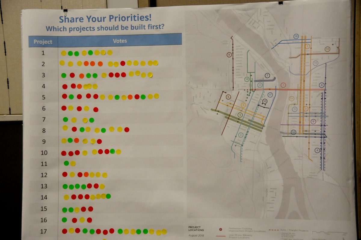
My ballpark estimate shows that PBOT has sliced about half of the $72.3 million price tag from their list of 18 projects, bringing them much closer in line to the expected funds they have to spend.
The email from BBPDX is supportive of the projects overall and demonstrates a collaborative relationship with PBOT. This stands in contrast to the recent statement from the Central Eastside Industrial Council which urged its members to voice concerns over how the Central City in Motion project would reduce parking in their district.
We have not seen any publication of this new map or an explanation of the prioritization decisions from PBOT. We’ve reached out to them for comment and will update this post when we hear back.
— Jonathan Maus: (503) 706-8804, @jonathan_maus on Twitter and jonathan@bikeportland.org
Never miss a story. Sign-up for the daily BP Headlines email.
BikePortland needs your support.


Thanks for reading.
BikePortland has served this community with independent community journalism since 2005. We rely on subscriptions from readers like you to survive. Your financial support is vital in keeping this valuable resource alive and well.
Please subscribe today to strengthen and expand our work.
Curious that the Martin Luther King/ Grand work was removed. It seemed like a terrific opportunity to move buses and street cars throughout that corridor more efficiently, while making MLK and Grand safer roads to cross. It appeared to have considerable support.
At the City Council hearing on the Enhanced Transit Corridors a member of PBOT’s Freight Committee (I think) to turn up to say that freight interests would support transit lanes if they would allow use by freight vehicle as well. The idea for the MLK / Grand corridor seemed like a great way to leverage support from an interest group that’s sometimes hostile to transit / active transportation improvements. I wonder what happened?
If I’m moving a refrigerator with my pickup truck, do I get to use a “freight” lane? What about a Uhaul moving truck? E-bike delivery service?
Most likely no to all, though it’s all TBD given that we haven’t done this before. The simplest line to draw would be that vehicles subject to the weight-mile tax can use a transit / freight lane.
It’s pretty incredible to see a map that includes no projects serving the Pearl, which, despite being Portland’s densest neighborhood, has almost no bicycle infrastructure.
How do you feel the needs of the Pearl stack up against the rest of the central city at large? Comparatively speaking the Pearl is dense, streets are narrow and speeds are slow.
I used to live in the neighborhood, and still visit it often, including today at lunch today, to go to the dentist. My experience is that cycling in the Pearl sucks. It’s true that speeds are relatively low on most streets, but traffic does get fast on NW 14th and the Everett/Glisan couplet. The bigger problem is that traffic can be heavy. You have the choice of taking the lane and getting stuck behind cars at the intersection, or squeezing in between cars, which I hate doing. When taking the lane you’ll often have a car trailing behind you, which doesn’t stop me from doing it, but would be very intimidating to many other riders.
Generally my experience as well.
I’ll add that getting stuck behind autos is frustrating (I’ve experienced this a lot in the central city), but getting stuck behind cyclists in a bike lane is equally as frustrating. It’s part of the bargain of density and living together.
I don’t think I’ve ever been stopped behind so many bikes in a bike lane that we couldn’t all get through the intersection while the traffic light was green. That happened to me today when I was stuck behind cars.
Exactly that happened to me yesterday crossing through the broken intersections at 8th, 11th, and 12th adjacent to the orange line.
To clarify, too many bikes to get through the signal. There were at least 10 of us.
Today it was Maseratis, they were everywhere, they’re loud and the persons in charge always want their own lane. Damn. But I actually don’t recall that many moments of aggravation being stuck behind bikes in a bike lane. Bike riders move more or less at the same speed and in Portland they’re always chasing the next green anyway. Very few Dutch people in Portland. If I just can’t be behind a particular bike anymore I pop out into the other travel lanes that are there, likes sandwiches in the desert.
All modes of travel through the Pearl (especially the inner area around Powell’s bookstore) are problematic. It’s still somewhat porous for bike riders who are not intimidated by the mess but the whole area is hard to approach and traverse for users of personal cars, trucks, and sometimes even for trolleys. It wouldn’t be any worse for car operation if some streets, for example NW 13th, were made car-free. Before car-free: really annoying to drive there. After car-free: really annoying to drive there, but with more interesting places to visit and a better quality experience for >people< while they are there. Why do we put any energy into providing a quality experience for cars? Cars don't give an (emoji) and they don't pay taxes.
Also: NW 9th. Could be car-free. Lots of places to visit (restaurants, galleries). One hotel has car valet service but that could be accommodated with a half-width one way block. Once property owners realize that their property value goes up when the street is an attractive place they’ll support it. But wait, before that can happen the city would have to do something, something–what is it they would have to do?
I avoid driving in the Pearl just as vehemently as I avoid uptown or downtown driving in general, so AFAIC, the bicycle infrastructure in The Pearl works perfectly. But, it’s not all about me, and I understand completely if others aren’t comfortable riding those streets. It can be frustrating. Duck and dive, swerve and brake, stab it and steer. Yow!
PBOT sabotaged SE 11th and 12th by proposing crappy bike lanes.
I hope the folks in this neighborhood like truck traffic and air pollution. They’re going to get more of it with PBOT’s love-affair with UPRR railroad and their need for truckers to blast shipping containers through this part of town back and forth between rail yards. When they say “freight access” they mean “railroad shipping containers taking a short-cut through Portland neighborhoods on old dirty diesel semi-trucks”.
Sometimes I just don’t understand PBOT. NW Portland should have the best bike infrastructure in the city, considering density, yet they continually ignore that area. Super disappointing to see those NW projects removed. What a sham.
It underscore teh overall lack of planning vision. the City has suffered from for the last couple of decades. Portland has been resting on the laurels of the good planning from the 70’s-90’s. Many of the streets in the Pearl have been rebuilt and many of those by developers having to do half=street improvements. If Portland had had decent infrastructure adopted and in place, we would have the dream network now.
Parking, parking, and parking.
I’d like to see better pricing put on all that parking. $2/hr is clearly too cheap when people are willing to circle the block, make dangerous mid-block u-turns, double park, and speed to get a spot before someone else.
One way is to look at how much the private market charges for parking. What’s a nearby lot charge?
A quick check and it looks like rates range from $4-$6/hr for private lots and garages. That’s a pretty huge difference.
I would agree that if the city’s focus were maximizing revenue, it could probably raise rates (and would probably offer longer term parking).
https://www.bestparking.com/portland-or-parking/?view=map
And Seattle is like $12/hr.
Is there somewhere in Portland that HAS good bike infrastructure?
I guess South Waterfront. They do have that great cycle track along Moody.
I love my greenway commute down Ankney/Davis. Hickups include the Ankeny/Sandy crossing and the Burnside Bridge but other then that, things are getting better
We should expect any plan that takes away a car lane on major rush hour routes to be rejected.
I like 7, 2, 3, and 9 myself.
I’ll never understand why anyone thinks it’s a good idea to take the few overloaded rush-hour commuter roads we have, remove a car lane and put a bike lane in its place.
Everything points to Greenways and generally separate main arteries for cars and bikes as the right solution.
Greenways and separate infrastructure are the way to make biking better in Portland.
Since you are in favor of car-only roads, I assume you are also in favor of LIT-only roads too, yes?
Sorry sikoler but I just looked in my Devil’s Dictionary and it said: Greenway (n): a street that wasn’t too bad for bike riding but then you spend $1.5 million and it doesn’t suck all that much for bike riding.
Separated infrastructure: OK, just as long as it’s equal.
Mixing rush hour traffic and heavy bike traffic is the absolute worst idea and will yield nothing but pollution from commuters idling in gridlock and injuries to cyclists.
We absolutely must work together with all parties,
“We can’t handle the loss of 250 parking spaces. We would like to work with the City and the bike community to find a more measured and balanced plan.”
— Kate Merrill, Central Eastside Industrial Council executive director
This idea that you can satisfy all stakeholders is idealistic. Pursuing “compromise” is great for politics I guess, but road space is finite.
When you start from a position 1) we can’t remove parking and end with 2) we want to work with the city, you end up getting projects like the 20s greenway where it misses all the commercial destinations, ends up requiring North/South through traffic to change streets a half dozen times, and doesn’t really accomplish any of it’s stated goals. That’s not an acceptable model for designing projects.
We could design projects based on prioritizing pedestrians, transit, biking, and (lastly) single occupancy commuters. PBOT/City Council knows this; that’s why they created a modal hierarchy pyramid based on that ideal. But, here we are again, worrying about minimizing parking (in the central city no less.) Good times.
“When you start from a position 1) we can’t remove parking and end with 2) we want to work with the city you end up getting projects like the 20s greenway”
absolutely not, it does not have to be this way
I feel like many here (and in PBOT) have surrendered without a fight, in a battle we can win.
This is a truth everyone must learn: we can prioritize bike and commuter traffic simultaneously.
Our foe is the notion that to elevate one (bikes) we must push down and hobble the other (commuters).
We’re smart enough to make our traffic system work for everyone.
Except, Vancouver literally mixed heavy rush hour traffic with heavy bike traffic in separated, protected lanes, and it caused their bike commute mode to explode in a span of just a couple years. They now register 10% or 11% mode share for bike commutes (depending on source), and that was around 4% just a few years back. Bike Portland even did a piece on it. And the car mode share has actually dropped. I can’t think of a better way to incentivize biking than sitting in traffic in a car as bikes whiz by. People want to get from A to B the quickest, and right now, we should prioritize cleaner mobility at the expense of transportation modes that negatively impact our air and public health. Vancouver gets it. Portland leaders and PBOT are stuck trying not to offend people. As Bike Portland outlined, Vancouver had massive backlash from the business association, which turned around and now completely supports those bike lanes (and is asking for more). There has to be stark change and sacrifices for the greater good and future generations, unless we think climate change is a Chinese hoax like the president.
Portland leaders and PBOT are stuck trying not to offend people
More like:
“Portland leaders and PBOT are stuck trying not to offend wealthy people.”
Opinion polls show that there is broad support for traffic safety and alternative transportation modes in Portland. The problem is that our political system and city government is structured to elevate the voices of privilege over the voices of working class folk.
Working class people are demanding making driving harder to make cycling better? This is so not a class issue.
It’s not a race issue either.
“Until [we in the bike community stop the turf war mentality], people in cars are going to keep cutting through them at 25MPH”
fixed that for you
see, the problem I think many in the bike community ignore is that the cars aren’t going away.
People still have to get where they are going, and by working actively to make the most important rush hour areas more congested we are just making it worse for ourselves.
We have to work together, the turf war mentality is only making it worse for cyclists.
“working actively to make the most important rush hour areas more congested we are just making it worse for ourselves.”
toxic emissions, negative impacts on health, traffic violence, divided communities, and ongoing climate change are all making it worse for ourselves. is short-sighted driving convenience more important than the health and future well-being of young people?
You seem to have a turf war mentality. I’m not really seeing that attitude in any of the other comments here.
on paper, you can move more vehicles per hour in a bike lane than a motorvehicle lane, so yes in dense urban areas there are places where it makes a lot of sense to remove a car lane and put in a bike lane. Yes, this is on paper and putting in the lane will not magically result in congested bike lanes on day one but when you think about the big picture and what the city should look like in 10-20 years, its makes a lot of sense. Fortunately we are not the trailblazers here and we can look at other cities around the world that have had great success and copy their approaches. Unfortunately, everything does not point to greenways and separated main arteries for cars and bikes as the right solution. Copenhagen’s bike network serves as a good counterpoint to this line of thinking because they, like Portland, once focused on the greenways approach but abandoned it as a failure. They now have more bike trips entering the city than car trips.
“Everything points to Greenways and generally separate main arteries for cars and bikes as the right solution.”
Where’s your evidence of this?
Apparently, he thinks the 20s bikeway is a great solution for the NE/SE 20th conflicts. I wonder if he has ever ridden it.
OK, so I really really want to know how it’s possible that costs for Central City in Motion have gotten so out of control. As an example, I’ll take one project: #8, the SW Salmon / Taylor couplet.
The cost assigned to that project is $3,770,000. The design for the project includes 1.7 miles of protected bike lanes on one-way streets. Using a cost of $462,617 a mile (per page 100 of the draft Protected Bicycle Lane Design Guide) for a median barrier protected bike, that should come to $786,449. The design shows a new signal at SW 1st and Salmon. That’s already signalized, so I assume modifying the existing pole is all that’s needed, but let’s be generous and say that’s a $250,000 cost for a full rebuild. 6 bus stops are shown on Salmon. I can’t find a recent unit cost for bus bulbs, but $100,000 each seems like a really high number that works for the purpose of discussion. I’m now at $1,636,449 with some pretty padded numbers. How do I get to $3,770,000?
Got to make sure the fat cats are fed!
Yes. Keep in mind that price ($462,617) is an estimate per mile for a fully separated design via a “median barrier.” The price per mile of, for example, planters is less than half: $157,609. Would it make more sense to fund more (all?) projects using basic materials and have a greater effect on safety and expanding the bike network? PBOT, please make it safer, not prettier.
Yes. I picked the high cost option for the purpose of making my point, but if we can afford to build out the full network using planters or precast traffic separators we should seriously look at that. It should be possible to do a few signature projects (i.e. Broadway / 4th) at the highest quality, while doing the rest at a medium quality. As long we’re moving past the paint and plastic wands level of quality I’d be happy.
planning, design, staff time, outreach, inflation, wiggle room for overruns…
It’s amazing how much overhead and “outreach” there is for active transportation (and how little PBOT funds go to public transportation). It’s almost as if PBOT’s stated goals to move away from automobility are not made in good faith…
$2 million is a heck of a lot of wiggle room. And if the numbers in the Portland Protected Bicycle Lane Design Guide are so far off, it invites the question of what the point of it is?
i guess I don’t share your skepticism of PBOT’s motives with these cost estimates. At this state of the game, there’s a lot we don’t know about these estimates and I trust that PBOT isn’t trying to pull the wool over our eyes with them. I think they know how to make a good estimate and there are likely things that went into these estimates that make perfect sense. just trying to say i’m all about being skeptical of PBOT’s motives when necessary.. i just don’t see the conspiracy/concerns on this particular issue.
UPDATE: Here’s what CCIM project manager Gabe Graff just tweeted:
To be clear, I’m not implying anything at all about motives. I’m just concerned that the project costs are so high that it limits the ability of how much we can do with the available funding, which is a very real constraint.
I hear you Iain. Thank you.
To explain a little further where I’m coming from on this: in my profession (architecture) it’s common to get cost estimates at every stage of design, so that we can track to a budget. When we get cost estimates that are high, we scrutinize what’s making the numbers high. Sometimes it’s because we’ve made a really expensive design choice. Sometimes it’s because of a client requirement that when push comes to shove the client doesn’t really need. Other times it’s because the person doing the cost estimating has limited information at early stages of design, and has way over estimated what is needed.
So with that background, I look at some of these projects and can’t even begin to imagine where the costs are coming from. How can a six block long bus lane on NW Everett St cost $4.26 million?
Excellent point. In a lot of industries, cost estimates align with specific measurable objectives about a project. In this manner everyone knows the ultimate goal and how one might get there most efficiently. The long term goal for a project could be “Lowering injury/death to x# on x road using the x cost by x date.” A short term goal might be “At intersection x, using x design will result in x injuries/deaths in one year.” Building a beautiful and extremely expensive curb-protected bike lane may have a negligible increase in safety over bollards/planters.
The NYC DOT recently came out with a study comparing the risks of each type of intersection:
https://nyc.streetsblog.org/2018/09/25/dot-seeks-better-designs-for-intersections/
Intersections are where the vast majority of conflict occurs. Intersections must be the focus if safety is the goal. PBOT would be more effective making measurable goals centered around safety and ridership increase, focus on measurable interim or “transitional” projects, and not the prettiest ultimate product.
Those new curb extensions can be done incrementally with paint, plastic wands, and/or plastic curbs as they are doing currently throughout Seattle. It is cost effective, allows data collection, and design refinements before finally committing to concrete and sidewalk rebuilds. I appreciate Graff’s thoroughness but it can be needlessly restrictive to only consider full rebuilds within the cost estimates when other demonstrated options exist. Safer crossings help us all and are needed on the greenway crossings of arterial roadways.
Thanks for your comment maccoinnich. There are three reasons why costs are higher. First is that we redid estimates for construction costs of protected lanes from the draft version you’re referencing. Estimate per mile construction cost is now $584,000 for a concrete island protected bicycle lane (formerly “median barrier”). That cost is for retrofits for the protected elements, only. Second, that estimate neither includes intersection treatments, nor does it include any other improvements on the corridor, as Gabe mentioned. The CCIM projects include much more than the protected bicycle lane. Third is that these are construction costs, only. To get a sense of total project costs it’s necessary to apply a factor of approximately 2.5. If you look on page 101 of the protected bicycle lane guide you’ll see a “Construction cost multiplier” of 2. We upped it to 2.5 following review by our civil designers. That takes into account all the soft costs: preliminary engineering, construction management, overhead, mobilization, traffic control, construction contingency, et al. It also does not take inflation into account, which the CCIM fully-loaded estimates do.
Also, one thing to keep in mind is that we are simply prioritizing projects. We are not eliminating any of them. If projects are bid for less than our estimate or when we identify more funding, then we can begin to implement the next set of priorities.
Hope this is helpful.
Thanks for reply Roger. I still think these costs are really high ($4.26 million for a six block long bus lane, even with two new signals?), but it’s good to know that they’re only being used for prioritization purposes and not elimination.
As for the costs in the design guide: I can completely understand leaving out soft costs like engineering, but I would think that costs such as overhead, mobilization, traffic control, etc would normally be part of the contractor’s scope of work, and therefore placed in hard costs. Either way, having tables where the construction cost is only 40% of the project cost is pretty misleading way to present data intended to be used for planning purposes.
I understand that. We wanted to display construction costs, only because not all projects go to contract. Those performed in-house by PBOT staff don’t incur all the soft costs. Construction-only costs just seem a good basis for comparison. I understand how that can be confusing.
It’s not confusing. Things like traffic control have to be performed by someone, whether the work is contracted out or performed in house. Given that it would be part of the contractor’s scope if contracted out, it makes little sense to allocate it to soft costs.
Soft costs are 150% of hard costs for PBOT bike projects?
Is that normal?
I went looking for soft vs hard costs for public infrastructure projects and came up with soft costs in the broad range of 15% to 60% of hard costs.
E.g. – and some of these include roadway projects:
https://www.seattle.gov/util/cs/groups/public/@spu/@engineering/documents/webcontent/02_015864.pdf
http://www.infrastructureontario.ca/WorkArea/DownloadAsset.aspx?id=34359740000
https://www.cga.ct.gov/2017/rpt/2017-R-0206.htm
Granted there is a big difference between project types. Maybe the fact that PBOT bike projects involve pretty simple construction (paint, curbs, signage, signals) makes it easy for soft costs to dwarf the hard costs. But that raises questions too.
I think soft costs of $2.5 million for a project that is typically a mile or less of bike or bus infrastructure could use some explanation.
Soft costs are “preliminary engineering, construction management, overhead, mobilization, traffic control, construction contingency, et al.” What’s the average hourly rate of the people involved, from engineers to managers to flaggers? At $50/hr, $2.5 million is 50,000 person hours consumed without pouring an ounce of concrete.
I’m also interested in how much of the soft costs is “overhead” and what exactly is included in overhead. “Overhead” should never include PBOT’s fixed expenses: expenses that will not be any different if the project is done vs if the project is not done. Because if you are trying to decide whether to do a project, those fixed expenses are not relevant to the decision.
Thanks for chiming in Roger. This really helps.
PBOT is making some really silly mistakes on this.
Firstly, far too many choices and variables for any lay citizen to equitably evaluate the proposals. I tried to study the various options and details on their jenky website and just gave up. Too much/not enough information to make an informed selection.
And honestly, I have a hard time summoning any sense of urgency for projects which do not negatively impact me personally. I can’t imagine others would not share this bias.
The barely-attended open house seems to have had a hugely disproportionate effect on the outcome.
Not to sound like a broken record here but arn’t we paying whole floors of PBOT staffers to figure this stuff out? Maybe we can just get rid of them and build more miniature bike roundabouts with the savings.
It says 11th and 12th were rejected due to “neighborhood opposition”. I know that’s a project my neighborhood (HAND) has been advocating for for years.
They really need to get called out for this, and other reasons outlined in this discussion. When this plan goes to city council, we as advocates need to show up in large numbers to express our concerns and frustration over this process. City Council needs to know that more needs to be done, and PBOT needs to revisit their approach. They’re far too sensitive to the business and freight lobby. Grow a spine!
“They’re far too sensitive to the business and freight lobby. Grow a spine!”
PBOT is far too sympathetic to the business-as-usual rich insiders that Portland voters keep on electing to city council. In fact, this is why I am optimistic about Eudaly being in charge of PBOT.
The triumph of hope over experience.
Has that “experience” (e.g. support of the donor class) worked out?
Management skills are important when managing things.
Your faith in Mayor Wheeler’s mangement skills is very amusing.
I’ve never expressed an opinion on Mayor Wheeler’s management skills. You have expressed optimism PBOT under Eudaly will not be “business as usual”; i.e. that things will change while she is in charge. It’s early days, and so far we have a split verdict: we lost Better Naito, but on a different schedule than originally planned.
I truly hope you are proven right in the end.
I’d like to know more about this too. When I lived in Brooklyn and most of my destinations were to the north of there, I often rode 11th/12th, but only when I was in a hurry. There’s no really good north-south route east of there for a long ways (sorry, the 20s Bikeway doesn’t count), and it’s begging for protected bike lanes. This was one of the projects I voted for at the open house a couple weeks ago, and I’m disappointed to see it dropped.
The only major problem I see with this project would be the backups on northbound 12th behind the Sandy/Burnside/12th 5-way fustercluck, and on southbound 11th behind the tracks just beyond Division. Both of these are subject to major queuing today. Although 11th and 12th don’t really need the capacity of two lanes each direction for most of their length, the doubled lanes are useful for queue storage if nothing else. Perhaps we can have two lanes in the last block or two approaching these choke points, and eliminate street parking to make room for the bike lane? Also may make some sense to have visual treatments that help reduce the number of drivers who block intersections while sitting in those backups.
To all of you critiquing PBOT, please notice Maus defending them. This is not a singular event and it is soooo depressing to witness.
Have the costs of travel to accept awards been accounted for?
A short list of things I won’t miss from the seat of a bicycle when project #2 is implemented: Getting stuck in auto traffic on SW 4th Ave. Being in the middle of auto traffic on SW 4th Ave as the safest option knowing I’d never ask my parents or kids to be out there too. Pretending a bike lane exists in hotel zones. Doors. Right hook threats at NW Glisan & Broadway. Right hook threats at SW Jefferson & Broadway. Motor vehicles in the bike lane by PSU. Feeling frustrated it excludes so many people from participating.
I’ve always liked the middle lane on 4th and feel it is quite safe. But of course I recognize others wouldn’t feel the same. That said, the convenience of no congestion in the new left-side bike lane during rush hours will probably make up for having to deal with left hand car turns during all hours (i.e., waiting at signals). Assuming, of course, I don’t get left-hooked.
As a vehicular cyclist the middle lane feels safe to me as well, but we need to ask ourselves whom does vehicular cycling benefit. It is pretty clear it only benefits strong and fearless riders (<1% of cyclists) and drivers (maybe). Whom does it exclude? Basically everyone else. Why and what are the best remedies? In lieu of more car-free streets, which I'd much prefer, protected bike lanes are the next logical possibility. The parking along at least one side of 4th & Broadway has got to go. Same thing for many other streets on the project list. Fortunately for PBOT, NYCDOT is already proving over time what is working and what is not.
http://www.nyc.gov/html/dot/downloads/pdf/cycling-at-a-crossroads-2018.pdf
It sounds like you think conditions are better in the protected lane on 2nd than in the center lane on 4th. My fear of getting hooked makes me disinclined to agree.
Working class people are demanding making driving harder to make cycling better? This is so not a class issue.
Looking for clarification on the NW 4th Ave portion from those in the know. What’s the expectation where the new bike lane would end at Flanders? It looks like the portion of Broadway north of Burnside would get protected lanes both directions, but I don’t see any CCIM project for a connection between 4th and Broadway? That seems strange for a “couplet.” Is there a different project happening that would relate, for instance as part of the Flanders overpass project?
Yes, Flanders is going to upgraded to a neighborhood greenway between NW 23rd and Naito. It’s being funded and planned separately from CCIM, so doesn’t show up on those maps. In order to preserve parking the latest CCIM proposal drops the northbound bike lanes on Broadway between Harvey Milk (Stark) and Flanders, but keeps them north of Flanders.
Wouldn’t it be cool if this project had Identified the park blocks? Today they are little more than car storage and cut throughs.
Parking should just be called private property storage. Call if for what it is.
Except that if you actually try to store other kinds of private property in the road, it will get hauled away.
My neighbor’s 3 year old pile of wood chips says different.
That says to me “free wood chips, help yourself.” I wonder if you could put a locked storage shed out in front of your house.
Plenty of people do.