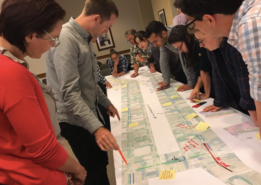
(Photos: Jonathan Maus/BikePortland)
“There are some projects where we looked at the right-of-way and thought, ‘What is the highest and best use?’ And in some cases that’s mobility. Moving people and not storing parked cars.”
— Gabe Graff, PBOT project manager
With over 6,000 public comments and nearly six years of planning, the end is finally in sight for the Central City in Motion project. This ambitious undertaking aims to transform dozens of Portland streets from driving-centric thoroughfares into more humane and efficient corridors that move fewer vehicles and far more people through our existing right-of-way.
Since we checked in on this project two months ago, the Portland Bureau of Transportation has: come up with cost estimates for 18 project “bundles”; announced the final public outreach events before they hunker down and develop a final ordinance to be debated by City Council on October 25th (tentative date); created detailed conceptual drawings for each project; analyzed impacts on auto parking and driving access; and published what they call a, “people moving capacity increase” for each project.
This morning, PBOT released a new phase of their online open house that allows the public to prioritize the projects based on a limited budget. PBOT’s new estimates put the total cost of the 18 projects at $72.3 million. They have $9 million in-hand and an “optimistic budget forecast” of about $30 million.
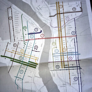
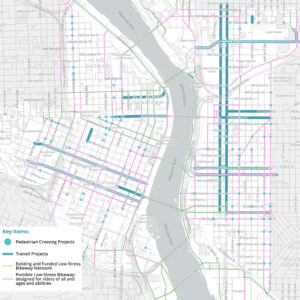
Here’s the list of projects (not prioritized):
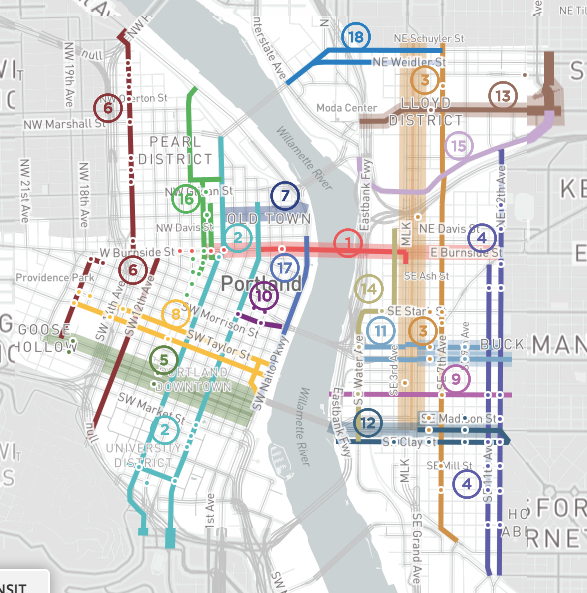
1) Burnside – W 10th to E 12th: $5,300,000
“Burnside was established as the city’s east-west axis in 1912. A critical street ever since, this proposal will make Burnside more efficient, allowing it to carry more people as the city grows. The proposal includes a Bus and Turn lane, a series of crossing improvements, and protected bikeways. These investments will provide faster, more reliable TriMet service, improve safety and accessibility on West Burnside approaching the bridge, and facilitate more cycling trips across the river.”
2) NW/SW Broadway / 4th: $6,620,000
“This project would create a signature north-south bike facility on the 4th Avenue and Broadway couplet, while upgrading unsignalized pedestrian crossings in South Downtown. The couplet would increase access for people biking to major destinations and employers, including PSU and the downtown retail core and increase crossing safety along both streets.”
3) NE/SE MLK / Grand / 6th / 7th: $8,530,000
“Coordinating to serve freight, auto, transit and bike needs, these projects would improve how people through the heart of the Central Eastside. MLK and Grand would include Bus/Streetcar and Turn (BAT) lanes that could also accommodate freight. New pedestrian crossings of MLK and Grand would improve saftey and access. Protected bike lanes on 7th Avenue would connect the Sullivan’s Crossing to the Tilikum Bridge. 6th Avenue, the likely location of the future Green Loop, would include new pedestrian crossings.”
4) NE/SE 11th / 12th: $7,800,000
“11th and 12th Avenues are an important north-south route for freight, transit, autos and people biking. Today the roadways feature two narrow travel lanes that don’t accommodate trucks or buses well. They are also difficult to cross. The project would redesign the roadways to include one wider travel lane to better accommodate buses and trucks, a buffered bike lane, parking, and a series of pedestrian crossing and bus stop improvements.”
Advertisement
5) SW Jefferson / Columbia / Madison: $3,000,000
“Multiple bus lines use Columbia and Jefferson to connect from Goose Hollow to the Hawthorne Bridge. These streets are also critical east/west connections through downtown Portland for cars and trucks. The proposed project would improve transit reliability and speed by adding a Bus and Turn lane and bus stop improvements. Traditional bike lanes would also be provided.”
6) NW/SW 12th / 14th / 17th: $3,030,000
“These streets work together to provide access to and from the Pearl District and through Goose Hollow. NW 14th would create a protected bicycle lane from Burnside to Hoyt, and a wide bicycle lane from Hoyt to Savier. Improvements to SW 17th Avenue would create a protected two-way, cycle track from Salmon to Alder, and a neighborhood greenway from Madison to I-405. A protected bicycle facility on SW 12th from College to Stark would provide access to the west side of the PSU campus.”
7) NW Everett to Steel Bridge: $4,260,000
“In addition to MAX and Amtrak, the Steel Bridge carries thousands of commuters on TriMet buses, including lines 4, 8, 16, 35, 44, and 77. This project would make these bus trips faster and more reliable by adding a Bus and Turn (BAT) lane on Everett approaching the bridge. It would address the ramps on the west of the bridge that create merging conflicts, further improving transit commutes out of downtown.”
8) SW Salmon / Taylor: $3,770,000
“SW Salmon and Taylor are proposed to become key east/west bike routes for people of all ages and abilities between Goose Hollow and the Willamette by creating a protected bike lane on both streets. They would link to the Hawthorne Bridge via a new protected bike lane on SW 1st. Pedestrian crossing improvements on both streets and bus stop improvements on SW Salmon are also proposed.”
9) SE Salmon: $600,000
“SE Salmon community greenway would provide a family-friendly bike connection to the Eastbank Esplanade and the Willamette River. This project would include improved crossings at the intersections at Water, MLK, Grand, 7th, 11th, and 12th.”
10) SW Alder / Washington: $1,400,000
“The Morrison bridge has a wonderful existing walking and biking path, but access to it poor. This project would improve pedestrian access and safety by eliminating dual turn lanes approaching the bridge. A short segment of two-way protected cycle track would connect 4th Avenue to the bridge, leveraging existing infrastructure to provide a critical connection between downtown Portland and the Central Eastside.”
11) SE Belmont / Morrison: $3,020,000
“Belmont and Morrison are key east/west connections in the Central Eastside, providing important retail, freight, and transit access. This project improves transit access and speed with new transit islands, improves pedestrian crossings, and provides protected bicycle lanes.”
12) SE Hawthorne / Clay / Madison: $3,810,000
“Madison, Hawthorne, and Clay are critical east/west connections for the Central Eastside due to their connections to the Hawthorne Bridge. This project includes a host of multimodal improvements to make these streets more efficient, including transit priority at intersections on Hawthorne and Madison, protected bike lanes on Hawthorne and Clay, and pedestrian crossing improvements on all three streets.”
13) NE Multnomah / NE 16th: $4,000,000
“NE Multnomah is a key east/west connection through the Lloyd District that provides access to retail and other destinations. This project would improve the existing parking protected bike lane on NE Multnomah and address bus/bike conflicts. A neighborhood greenway on NE 16th would provide a connection between this route and NE Portland neighborhoods.”
14) SE Water / Stark / 2nd: $2,520,000
“A two-way cycle track on Water Avenue would provide a safe and convenient alternative to the often heavily used Eastbank Esplanade, providing direct access to bridges and destinations in the inner Central Eastside Industrial District.”
15) NE Lloyd Blvd: $1,000,000
“This two-way cycle track along Lloyd would provide a cycling connection from the Steel Bridge to 16th. It would connect to the forthcoming Sullivan’s Crossing – a new pedestrian and bicycle bridge to be constructed over I-84 at 7th Avenue.”
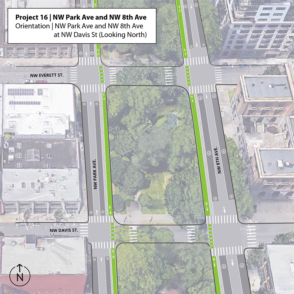
16) NW Park / 9th: $4,700,000
“This project provides a north/south connection from the Pearl District to downtown. Protected bike lanes on NW 9th transition to a protected bike lane on Park. New signalized crossings of Park at Glisan, Everett, Burnside, and Oak will remove barriers to walking and biking in this area.”
17) SW Naito: $4,000,000
“Naito Parkway serves as a critical transportation spine along the west side of the Willamette. This project would implement a year-round version of “Better Naito,” providing a two-way cycletrack and sidewalk along the west side of Waterfront Park. Signal timing, median work, or adjustments to the existing curbline would be utilized between SW Salmon and Morrison, to facilitate auto access to I-5 via the Morrison Bridge.”
18) NE Broadway / Weidler: $4,980,000
“N/NE Broadway and Weidler streets are a key connection between the east and west sides of the Central City. This segment of the corridor includes some of the highest crash intersections on our bicycle transportation system. This project would reconfigure travel lanes where feasible to create protected or buffered bike lanes for improved safety and circulation. The project would extend from the Broadway Bridge to NE 7th Ave to connect with existing bike lanes in the Lloyd neighborhood.”
Instead of building one-off projects in isolation, PBOT Project Manager Gabe Graff sees the CCIM effort as a way to build a network of, “Cohesive multimodal projects that will help PBOT meet the needs of a growing Central City.” The city expects 37,000 new households and 51,000 new jobs in the Central City (east and west of the Willamette) by 2035. That’s a 30 percent growth in population in just 3 percent of the land area.
To emphasize how these 18 projects address that challenge, PBOT is using a metric (borrowed from Vancouver, Canada) that looks at how many people can fit in a street — not just how many cars. PBOT used a baseline number of 850 people per hour, which is a typical downtown traffic lane capacity. They then looked at how many people could move through a street in transit vehicles and in protected bike lanes (based on studies by NACTO, the National Association of City Transportation Officials).
By adding protected lanes on SW 4th between SW Barbur and Flanders in Old Town, for instance, PBOT estimates they can move 65 percent more people through the street.
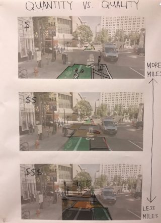
Graff said that type of analysis is crucial because the expected efficiency gains of these projects, “Were not coming across in a very compelling way to everyone.” As we mentioned back in June, some active voices have expressed major concerns about how this project will impact driving times and auto parking availability.
On that note, Graff and his team have been busy trying to quantify parking losses and associated concerns. To ease anxieties among stakeholders like the Portland Business Alliance and others, Graff said they’re working on a “parking mitigation strategy.” That is, PBOT is putting together a report that will detail how the agency will continue to provide ample auto parking as these projects are completed. It will include information about how to better utilize existing parking garages, where to implement pro-time parking (where parking is allowed during off-peak hours); drop-off/pick-up zones for taxis and rideshare vehicles, and so on.
“What was a dedicated bus lane during the peak hour could become a taxi or TNC [transportation network company] zone in the entertainment district, or a freight loading zone,” Graff said. “We are trying to think creatively about how we use the curb-zone and so that is a conversation we are having.”
In the end, Graff said the CCIM is about “making our streets more efficient.” “There are some projects where we looked at the right-of-way and thought, ‘What is the highest and best use?’ And in some cases that’s mobility. Moving people and not storing parked cars.”
PBOT’s aim with this final push of public outreach is to come up with an implementation strategy that separates projects into 0-5 year and 6-10 year construction timelines. Those dates are based solely on funding availability, Graff says, because all the projects are viable and shovel-ready.
If all goes according to plan, PBOT could break ground on the first project(s) starting next year.
To share your feedback, check out the online open house or drop-in at one of the upcoming open houses:
– Tuesday 9/18 from 4:00 to 7:00pm at OMSI Auditorium (1945 SE Water Ave)
– Thursday, September 13th from 4:00 – 7:00 pm at PSU’s Karl Miller Center (615 SW Harrison)
If you’d like to go deeper into the projects with local activists from Bike Loud PDX, they’ve planned a CCIM discussion night for September 10th.
— Jonathan Maus: (503) 706-8804, @jonathan_maus on Twitter and jonathan@bikeportland.org
Never miss a story. Sign-up for the daily BP Headlines email.
BikePortland needs your support.



Thanks for reading.
BikePortland has served this community with independent community journalism since 2005. We rely on subscriptions from readers like you to survive. Your financial support is vital in keeping this valuable resource alive and well.
Please subscribe today to strengthen and expand our work.
Most of these seem like like great projects, with the notable exception of one total stinker: 10) SW Alder / Washington: $1,400,000
“The Morrison bridge has a wonderful existing walking and biking path, but access to it poor. This project would improve pedestrian access and safety by eliminating dual turn lanes approaching the bridge. A short segment of two-way protected cycle track would connect 4th Avenue to the bridge, leveraging existing infrastructure to provide a critical connection between downtown Portland and the Central Eastside.”
The only reason you can ride a bike across this is BECAUSE there is not safe way to get on to the bridge from the east or the west side. If they make these improvements and provide a good connection, the path itself will be useless because it is way too narrow for 2 way bike and pedestrian traffic. IMO, they should scrap this until they have a plan to provide robust access on the bridge itself.
Funny. It’s like saying we should not improve the quality of public education. If we have better public education, more kids would want to attend public schools but the class rooms will not be big enough to accomodate them. Therefore, we should not improve public education.
“Let’s deliberately keep usage low on one of the few crossings of the river” is certainly a unique take.
That is not really my take. My take is that the infrastructure on the bridge can not accommodate 2-way bike and pedestrian traffic so spending a bunch of money to connect people to it is not a good use of funds. PBOT should work with the County on a coordinated project that creates safe, direct connections to the bridge and adequate space on the bridge for users.
You know you live in a city, right?
you talkin’ to me? Of course I do! A city with limited resources!
I would love to know more about how some of these costs were arrived at.
Do I believe that it costs $6.62 million to create a highway quality bikeway for the length of NW / SW Broadway / 4th? Sure.
Do I believe that it costs $4.26 million to convert one existing lane of NW Everett into a bus lane, for six blocks? Absolutely not. Even when accounting for two new traffic signals that’s an insanely expensive project, and that those kinds of costs we’ll never build out a bus priority network.
Similarly, the NE / SE 11th/12th projects seems super expensive at $7.8 million, especially given that all that’s being proposed is a Milk/Oak style treatment, with only three new signals.
FWIW the estimates were based on a mid-level quality of materials and finish.
What’s a mid-level quality of materials and finish for a bus lane though?
Might be significant storm water facility improvements as part of the projects. That can get the cost high pretty quickly.
A vast improvement over anything we currently have downtown?
I am also very curious about this. As far as I thought, they were not going to alter any curb cubs as part of 11/12th.
That spot is horrible, mostly due to driver behavior. Almost as bad as the 11th/Ankeny/Sandy cluster. That thing is a dumpster fire.
If we want to save $$$, we could turn some of these streets into car-free plazas by adding concrete planters to the intersections. We can “upgrade” the space to allow cars back in when we have the funding to accommodate them safely.
She also blew through that pedestrian crossing where another car had already stopped at .
Lethal.
I hope for a repavement project similar to Today Parks coming to Sandy sooner rather than later. It could be such a good bike route. Yet I avoid it whenever possible bevause of these types of situations.
License plate seems to be CA 64199, btw. See 7 sec in. That person could have killed someone at the crosswalk.
I was a bit underwhelmed by the lack of comprehensive, transformative nature of these projects. For example, why doesn’t the NW 9th/Park Avenue protected bike lanes continue south past Burnside? It would be nice to see the extents of these roadway re-allocations go further based on low, medium, and high quality of improvements. The city could basically build out the green loop with some paint, candlesticks and a number of intersection signal alterations in addition to completing some full-length and direct corridors to criscross the central city. As much as I like every single upgrade to bike, ped, and transit infrastructure in the city, I feel like we need a more comprehensive and practical plan that we know we can implement with the limited dollars available in order to achieve some serious bike and transit mode share gains.
Efficency gains of these proposed changes depend on how many people will use buses and bikes to get to work, and that in turns depends on the whole bike and public transit network. Economists call it a positive network externality, because every piece of infrastructure improvement has a positive effect on the utility of other infrastructure. That would be an argument for more sweeping changes from an efficiency point of view. It is also a dorky braggy thing to say at the next cocktail party …
Wow, this is indeed an ambitious project, lots of great improvements!
One gripe and one concern: I wish the city would finally transform one street to be pedestrian only. This could involve some segment of the green loop. I understand that the focus here is on efficiency, and that’s great because it is hard to argue against a more efficient transportation infrastructure. Still, I was wondering whether a pedestrian only street segment could increase efficiency while also providing other benefits.
My concern is that funding is not secured and with a 10 year project duration, the city is bound to experience a recession during that time period. How will the city prioritize funding when that gets tight?
SW Ankeny Street would be great to be free from cars between Broadway and Park Ave. There is a garage entrance on it, though.
NW Park is a great candidate for a near-term carfree street if PBOT would embrace that vision. So is NW 13th to a smaller extent.
NW 13th needs to be car-free. With no pedestrian facilities, I don’t see how we can safely allow cars. Start on the weekends and then extend it to full time.
Diverters every other block and elimination of 50% of parking would be a good start. All the open space from removing parking would be well used by the food carts at 10th and Washington when construction on that new tower starts.
Jonathan, did PBOT staff offer any intermediate steps on projects, or were most projects “finished” products only? For example, what Catie above suggests is an early Phase 1 type project whereby streets are simply closed with planters and maybe have tape to mark future features, but without affecting curbs. A Phase 2 might be to install temporary curbs instead of tape, street seating, more permanent planters, etc, while Phase 3 would be the full-meal deal of moved curbs, new islands, pavers, etc.
In many jurisdictions, Portland included, the sewers are due to be replaced in the next decade or so. While such projects are very expensive, they are usually paid for through water and sewer fees rather than gas taxes or parking fees. Many city transportation departments try to take advantage of these projects – since the curbs are going to be ripped out anyway, why not add wider sidewalks and/or protected bike lanes when the streets are rebuilt? And from PBOT’s point of view, they don’t have to pay a cent for the new infrastructure (except in design and public outreach) – it’s the ratepayers who will pay for them through their water bills.
Portland has been replacing sewers on a large scale throughout the older parts of NE for the better part of a decade, and I don’t think I’ve seen any curbs or sidewalks ripped up. It’s pretty much entirely in the roadway.
And I should add that the city just settled a huge lawsuit for misappropriating water and sewer funds, so anything that even smells like it’s not directly related to service provision is likely a non-starter.
Beware of the phrase “Highest and Best Use” when city planners start to use it. Here in Greensboro, when Council or city staff use the phrase “Highest and Best Use”, they usually mean (for traffic) how many cars can they get to access a new shopping center or (for land development) the maximum resale value of a given parcel of land. They never evaluate what the maximum social benefit that can be gained by a change in land use or a change in traffic use. And of course Parks, open space, or affordable housing gets a zero. I trust Gabe and several others at PBOT on their use of that phrase, but I’m very doubtful of the folks at PDC or on City Council, among others.
“MLK and Grand would include Bus/Streetcar and Turn (BAT) lanes that could also accommodate freight.“
What does that mean? A sign at every intersection that says “right turn only/except streetcars/except buses/except freight”? What type of vehicles are exempt as “freight” and how does a cop know that? “Freight” vehicles come in all shapes and sizes and this will be impossible to enforce.
“I drive a (small pickup) truck (to work) so it and I count as freight” means to me that many of the same people will be doing the same inappropriate things . Nothing smaller than triple-axel should qualify as freight.
Commercial vehicles have different license plates.
It’s pathetic that the plans for SE 11th and 12th call for a narrow conventional bike lane with a buffer that protects vehicle storage spots. SE 11th and 12th is a uniquely direct and flat route to NE Portland and should be used for mobility, not for taxpayer subsidized storage of people’s private property.
to and from NE Portland
I am still unsure how 11/12th is exempt from the “all new bike lanes will be protected bike lanes” directive that PBOT issued years ago.
because it was just a directive.. It is not a policy and it has very little strength. It has been good for boosting morale at the agency and giving protected bike lane believers a sense of purpose and urgency… But it’s really just a strong suggestion that has no lever of enforcement that anyone call pull.
And it doesn’t help that the person who wrote the memo/directive (Leah Treat) no longer works there.
I think we are going to see more of this problem/conflict in coming years.
As the city eliminates off-street parking requirements for more and more development, thus forcing more people to park their cars on the street, it will be harder and harder to eliminate the remaining on-street parking to create better bike infrastructure.
The idea that taking away parking will force more people to adopt car-free lifestyles is unrealistic. Most Portlanders will continue to own cars. The publisher of BP owns a car and most BP commenters own cars. If this group isn’t car-free, obviously you can’t expect the average Portlander to be. Maybe robot-driven Ubers will change that over time, but we’re a long way from that.
That is a general comment. For SE11th and SE12th specifically, I think eliminating some street parking might be possible, because a lot of that area is commercial property with off-street parking lots.
You don’t have to adopt a car-free lifestyle in order to reduce the number of trips you make by car. The whole point is to make it more efficient to bike or take public transit for a greater number of trips. It’s not that plenty of people in the Netherlands don’t own cars, for example. They do, but they just don’t use them for quick local trips because they don’t have to.
Agree, but *reducing your car trips* and *not owning a car at all* are pretty different things. Many or most people want to be able to own a car, which means they need to be able to park it somewhere, and if you have no off-street parking then losing on-street parking is going to be more of a concern.
If you push for both 1) eliminating off-street parking and 2) eliminating on-street parking, then that sums up to 3) eliminating all parking, and I’m suggesting that is going to cause an increasing backlash in the years ahead. A backlash that will make it harder to have good bike infrastructure.
Unlike the more suburban neighborhoods, most of the Central City has metered parking with no residential permits available. If people are renting apartments that don’t come with parking it’s unlikely that they they are parking their cars on the street.
or perhaps as car ownership (and parking) becomes steadily more annoying we will see more and more people switch to other modes…
Sure wish they attacked east PDX problems with the same energy.
fwiw they are using the East Portland In Motion process as a model for this one.
So will they also delay building anything important that gets funded for at least 15 years?
Oh come on…people from outer east portland will use the green loop too!!!!1!