(Photo: Jonathan Maus/BikePortland)
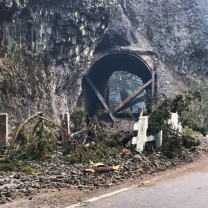
A six-mile stretch of the popular Historic Columbia River Highway State Trail that was closed due to the Eagle Creek Fire on September 4th of last year has finally re-opened. The news comes as the Oregon Department of Transportation opens a comment period on how to reduce congestion in the Columbia River Gorge.
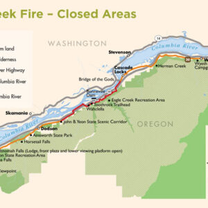
In an announcement this morning, ODOT said the paved biking path between the John B Yeon trailhead and Cascade Locks is now open. (Unfortunately, a separate section of the trail to the west — between Bridal Veil and Ainsworth State Park — remains closed and has no timeline for re-opening.)
The newly opened part is labeled as the Bonneville Segment on the map below…
The Yeon-to-Cascade Locks section had been closed for 13 months. The importance of this state trail is reflected in the fact that Oregon Governor Kate Brown commented on it: “The re-opening of the State Trail is a major step in the economic recovery of the region and brings us a step closer to make sure visitors from across the state and around the world can again fully experience the majesty this area has to offer.”
If you’re heading to the Gorge this weekend, ODOT has announced a few other access updates:
— The U.S. Forest Service parking lot and day use/picnic area at the Eagle Creek Recreation Site. The trailhead area and trail itself remain closed with no timeline for reopening.
— National Forest System lands north of Interstate 84 near Eagle Creek Overlook Campground, a common spot for fishing or viewing the Columbia River.
— The parking lot at the Toothrock Trailhead.
— The parking lot at the John B. Yeon Trailhead. Unpaved hiking trails at John B. Yeon remain closed as does the trail to Elowah Falls.
— Many other Gorge facilities operated by the U.S. Forest Service, the Oregon Parks and Recreation Department and the Oregon Department of Transportation remain closed.
Advertisement
Also this week, ODOT opened the comment period on their Historic Columbia River Highway Congestion & Transportation Safety Improvement Plan. There’s an online open house available through October 8th. An open house for the plan has also been scheduled for this Wednesday October 3rd from 5:00 to 7:00 pm at the Hollywood Senior Center (1820 NE 40th Ave in Portland).
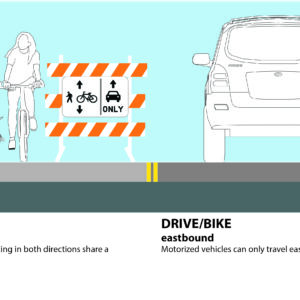
As for the six-mile section of this paved trail that remains closed, ODOT’s plans for a “phased re-opening” that could include an experimental carfree lane, have been pushed back until spring 2019.
In an email to BikePortland this week, ODOT’s Columbia River Gorge National Scenic Area Coordinator Terra Lingley shared this update:
“The one-way configuration is still on the table, just delayed until next Spring. Since the Historic Highway is still closed, we didn’t have enough time to implement the one-way, gather data and remove it in time for winter maintenance operations. The Phased Reopening is tangentially related to the Congestion and Safety Plan, and we anticipate gathering data to help inform some longer-term recommendations in the plan.”
Remember there’s a bike-friendly transit option that serves the Gorge. You can hop on the Columbia Gorge Express buses at the Gateway Transit Center and get a round-trip ticket to Multnomah Falls for $5 per person. Each bus can carry up to three bicycles.
— Jonathan Maus: (503) 706-8804, @jonathan_maus on Twitter and jonathan@bikeportland.org
Never miss a story. Sign-up for the daily BP Headlines email.
BikePortland needs your support.


Thanks for reading.
BikePortland has served this community with independent community journalism since 2005. We rely on subscriptions from readers like you to survive. Your financial support is vital in keeping this valuable resource alive and well.
Please subscribe today to strengthen and expand our work.
I don’t understand this path. The car-free portions look really nice, but it looks like the majority of it is riding on the shoulder of a busy highway? How are you supposed to get to the nice parts of the trail? Why call it a bike trail at all if the majority of it is shared with cars?
It’s not all a bike trail, and nobody is saying it is. Its a historic highway state trail, portions of it allow cars (which yes is misleading to call it a trail) and portions of it are closed to cars (which some people refer to as the “biking path”). Nobody is calling the portion open to cars a “bike trail”.
Actually looking at it the sections open to cars it is just called the historic highway route, not a trail. And you can get to these trails by parking your car at a trailhead, riding your bike to them, walking to them from nearby towns, taking transit to a trailhead… really any way you would normally get somewhere.
Most of the Historic Columbia River Highway doesn’t even have a shoulder, including the parts highlighted in the map here.
To understand the path is to understand the history of the route. I84 is the major motorized way to traverse the gorge. However, prior to this, existed the Columbia River Highway.
The old route was rugged and portions of it still exist. But to most who don’t know about the gorge, there is a lot that happened and changed the landscape. First and foremost are dams.
Oregon and Washington did a series of gigantic projects which calmed the Columbia river with dams. “From the Pacific Ocean. Four Federal dams on the mainstem of the Columbia River—Bonneville, The Dalles, John Day, and McNary—have navigation locks through which boats and barges can pass.” https://en.wikipedia.org/wiki/Columbia_River#Navigation
They allowed the river to be traversed all the way from the Pacific to Lewiston, Idaho. Previously, the river was rugged and each dam represents an area of the river that would not have been navigable to the next, requiring portage.
The historic highway was marginalized as I84 was created. Sections of it were blown up as they were deemed unsafe. This is why we have the hodge podge trail. It’s not purely for bikes and not purely for cars. It’s a relic of trying to traverse a difficult area which is important in the history of the Oregon Trail.
Many of the original pioneers had to traverse a combination of the wild and undamed Columbia in addition with roads built by pioneers such as the Barlow trail. The Historic highway represents what modern organization and methods could build alongside giant new dams that would bring electrical power to a region in the late 1920’s and 1930’s.
Excellent insight and write-up!!
Some other random tidbits: the town of Hood River was called Waucoma (cottonwood) by the natives. Its river was previously known as ‘dog river’; the story goes that the natives referred to it as the place where the early white settlers ate their dogs for survival during a particularly harsh winter. It was changed to Hood River about the time the mountain (Wy’east) was renamed to honor Admiral Samuel Hood.
Realistically, there’d be no way to rebuild the abandoned Historic Highway sections for auto traffic, thanks to updated road standards and insane costs. A trail is the only feasible option to keep the ROW open, and ODOT’s efforts to reconstruct the highway are something I applaud.
I’m not a local, so a bit confused.
If the section “between Bridal Veil and Ainsworth State Park” is closed, how does a bus ride to Multnomah Falls help? Isn’t that smack in the middle of the previously noted closed section?
The bus takes I-84, not the HCRH.
The closed section is a big problem for anyone looking to ride out from Portland, as you would have no option other than riding the shoulder of I-84. This opening is only useful if you are driving your bike out or taking the bus.
I encourage everyone to participate in that online open house and push for safer bicycle facilities and more support behind transit in the area.
This is just silly…why I appreciate the effort of ODOT, this equates to fake news. You still can’t ride from Portland to even Cascade Locks if I am reading this correctly. Bus to the a “path-head” (not a trail)? Defeats the purpose of riding a bike no? @JonMaus what’s your sense of timeline to get the section opened closest to Portland re-opened so we can once again ride from PDX to Cascade Locks? Any indication other than fire damage what the issue is? Landslides, re-design etc?
You have a very peculiar definition of fake news. It’s open. Just because it doesn’t serve your particular desire doesn’t make it fake.
It’s my understanding that in the me-first me-only brave new world of trumpism, the fact that it doesn’t serve that person’s particular desire is exactly what makes it fake news, to them. It has no bearing on the fact that it is no way in actuality the classic definition of fake.
Fake comment! I don’t even agree with it!
-Natasha
Hurray!!!!!!!!!!!
I can’t wait to ride to cascade locks again, I’ve missed it!
I never used the bridal veil path anyway.
Stay tuned as I figure out a date to lead a ride there.
Yay!!
How do I get to the the trail shown in the photo by car? I am planning to take my bike using the car, park somewhere near by and then bike. After reading the articles and comments, I am still not finding what all this means.
Which exit to take from I84? Drive to where?
I don’t have firsthand experience, but from investigating for myself, I’m pretty sure the options include: (a) Exit 35, then a few miles along Frontage Rd to the Yeon trailhead, the western end the carfree trail; (b) Exit 40 to the Bonneville Damn, lots of parking; (c) Exit 41 and parking there around Eagle Creek; or (d) exit 44 to park in Cascade Locks, which is the eastern terminus of this portion of the trail.
The Columbia Gorge Express also will get you to Cascade Locks at the eastern end.
Honestly, I just find the whole HCRH really confusing. I just want to go out there and ride car-free. As best I can tell, the longest stretch like that is 5 miles one-way.
I think ODOT needs to declare a few carfree days each summer on the highway, at a minimum.
Then I’m afraid that by it’s very nature the Gorge will never serve your needs fully unless you’re willing to adapt a bit. Because of the challenge of the topography in building the original highway 100 years ago what’s left can be divided into 3 fragmented categories:
1. Highway that ran over flat ground where available and now plowed over to construct I-84. These are a write-off unless someday completely new non-HCRH trail facilities are created. A flatter access from Troutdale to the waterfall zone would be a possible example.
2. Highway that for terrain, scenic value and access to both public and private property that the freeway can’t serve and are open to all vehicles. Other than at times of high congestion (when it’s basically stop and go), these sections are relatively comfortable slow-speed zones (it’s scenic after all) but because of access to homes and private property will never be non-motor vehicle. Between Bridal Veil and Ainsworth it is all public property I believe, which is why the experimental one-way lane + on-road bike/ped lane is being planned there.
3. Segments that neither provided needed access or were in the I-84 ROW and were simply abandoned. These are the really special jewels that ODOT/Parks are giving back to us, because as they are restored and re-opened they are all as non-motor vehicle trail sections. They include the article focus, the re-opened Yeon trailhead to Cascade Locks trail section (only 4-5 years old since first opened), the isolated, non-connected (other than by I-84 shoulder) segments along Lindsey Creek and Starvation Creek and segments like Shell-Rock Mtn, The Summit Creek Viaduct and the Mossy Road currently under construction that will connect the afore mentioned isolated segments when opened next year.
Then there are the non-HCRH public roads needed to string together a route that avoids any freeway shoulder riding like little used freeway frontage roads, quiet city streets through Cascade Locks and Hood River and the Wyeth Road climb between CL and Wyeth.
By next year it will be possible to ride from Troutdale to The Dalles with only 1 short mile long segment of shoulder before Hood River and that will be bypassed in the next few years. That is simply amazing given the previous experience. But as noted it’ll always be fragmented and require some route planning and ability to ride a variety of road and trail sections. It is worth going slightly outside your comfort zone though, it’s truly spectacular.
It’s not just my comfort zone I’m referring to.
That “1 short mile” is a long climb up a hill in a narrow, pocked shoulder with a rumble strip and big trucks or speeding cars revving close by.
So . . . If I want to ride out to Hood River or beyond, is it possible?
Not from Portland. You have to drive to a “trail” or take a bus. Well I guess you could ride on 84.
No, you cannot ride out to Hood River, not even with everything reopened. You can get a few miles past Cascade Locks, to Wyeth, on a mixture of paths and mostly-not-extremely-busy roads.
Beyond Wyeth, the Mitchell Point segment of trail has not yet been built. Your current options for riding to Hood River are (1) take the freeway shoulder, which is very dangerously narrow going past Shellrock Mountain), or (2) cross over to Washington and ride the narrow shoulder of busy SR-14. I would not recommend either option to even the most Strong & Fearless rider, though i would concede that if you insisted on doing it, you are slightly less likely to die by taking option #2.
Rather than trying to ride out to Hood River in the near future, far better to either take the Gorge Express out to Hood River, wait a couple years until the Mitchell Point stretch of trail is done, or get a folding bike and take Amtrak to Bingen (no baggage service and no access to the bike racks on the train at Bingen) instead.
With the Amtrak option you’ll still have to hitch a ride across the Hood River Bridge, which forbids pedestrians and cyclists.
It will be possible again after the closed sections of the historic highway are reopened.
The question was can you ride to Hood River without riding on I-84. The answer is no, not even when the closed sections are reopened.
Yes, though after both the fire closed sections and the new construction sections are open sometime next year, there will only be the “final five” mile section past Mitchell and Ruthton Points to complete. It was left to the end because tunneling Mitchel Pt will be the most difficult and expensive part of the whole trail. Hopefully in 5 years there will be a different answer to “can you avoid freeway shoulder riding the whole Gorge?”
I will be truly amazed if they can get that Mitchell Point section completed by next year. Astonished, really – that is some rough landscape that seems to reinvent itself every winter or two (and fall onto cars every once in a while).
Sorry if it wasn’t clear but the sections opening next year will only take you as far as Viento State Park. Mitchell Pt is still in design/funding. And would take at least 3 years to construct I’d guess after groundbreaking. So 5-7 years seems likely.
Yeah, you avoid the Gorge all together and ride out via the Springwater then roads adjacent to 26 up to Lolo Pass, then down into Hood River through the orchards. The scenic component is way better in my opinion, and there are so many road options that aren’t busy at all, even Lolo.
Does it seem obvious the way to remove congestion is simply remove the cars?
They could also remove the road.
Article needs to be updated. Highway is now fully open.
http://www.hoodrivernews.com/news/2018/nov/28/historic-highway-fully-open-again-vehicles/