
Portland could build 137 miles of protected bike lanes protected from other traffic with a planted buffer zone — and launch a transportation revolution with far-reaching benefits — for just $73 million. Or we could do it for about $34 million using plastic delineator posts. Those are two of many insights gleaned from the 124-page Portland Protected Bicycle Lane Design Guide just released in draft form by the Bureau of Transportation.
When we shared a sneak peek at the guide last month, PBOT Bicycle Coordinator Roger Geller said, “It provides much-needed clarity about what we can build and how it will fit on Portland streets.”
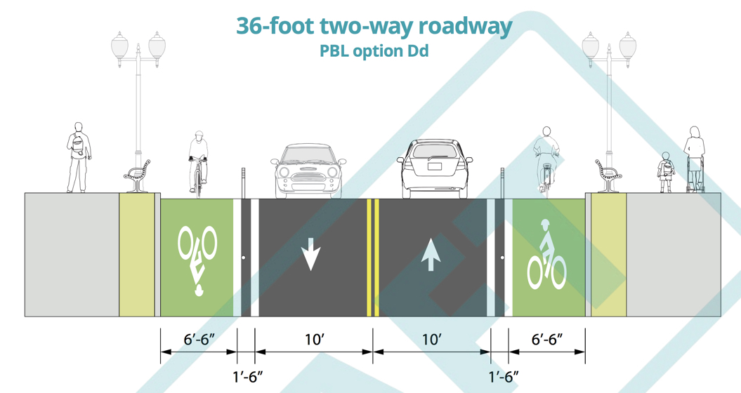
The guide offers engineers, planners, project managers and advocates a road map to retrofit Portland’s streets. From detailed cross-section drawings that can be applied to 28 different street configurations, to clear recommendations on what type of protective materials to use in specific situations, the guide should help hasten the development of protected bike lanes. If you’re an advocate for streets where fewer people die and where everyone — even those who don’t use cars — can get around more efficiently, you’ll appreciate the vibe in the introduction:
“The intent of the designs in this guide is to quickly and emphatically reconfigure Portland’s streets, not just so they operate in a safe manner, but also to communicate that bicycling is more attractive than driving and that bicycle transportation is accessible to people of all ages and abilities…Numerous studies from around the world, as well as our experience and the experience of cities with which we are allied through the National Association of City Transportation Officials (NACTO), have confirmed that providing protected bicycle lanes on busy streets is a key element to addressing the demand for better conditions for bicycle transportation. Such facilities are the highest quality bikeways, and are appropriate on roadways that include higher motor vehicle speeds and volumes.”

(Graphic: PBOT)
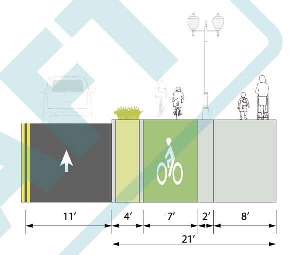
For engineers, the guide gives plug-and-play directions on how to redesign Portland streets. It breaks down the six categories of protected bike lanes — from basic ones that use plastic wands, to the City’s preferred design that puts the bike lane at sidewalk level and separates it from cars and drivers with a four-foot wide buffer zone. Engineers can use metrics like current volume of bicycle riders, parking availability, and speed of drivers to quickly determine which protected bike lane design is appropriate for the context.
For project managers and politicians, the guide lays out cost estimates and even calculates the expected decrease in on-street parking supply when various bike lane designs are implemented.
Does your project reconfigure two miles of roadway? Now you know it will cost about $70,000 per mile for low-end protected bike lanes and up to $2.8 million per mile for larger streets where you should separate the bike lane from other lanes with a full concrete median.
Advertisement
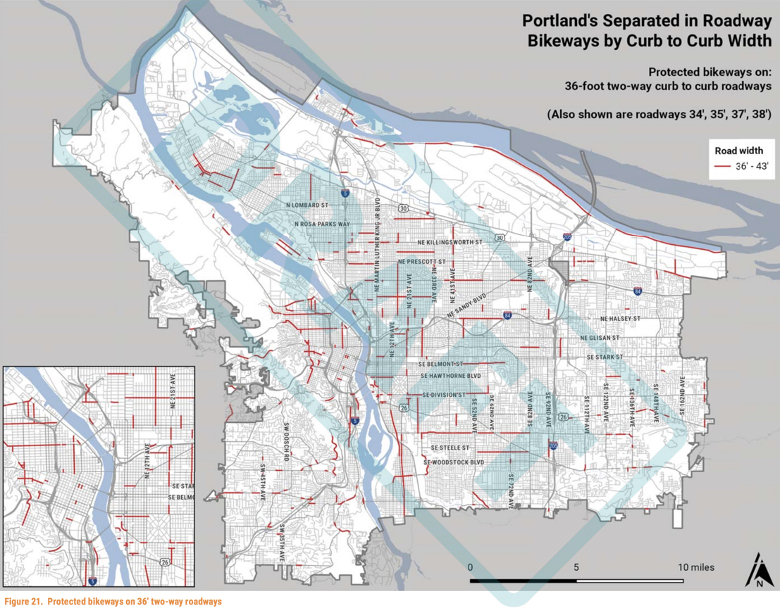
Politicians: Are you scared about negative media coverage or do you have an election coming up and have concerns about people who will complain about a “loss” of “their” parking spaces? The guide shows that if Portland implemented 30 percent (137 miles) of the 460 miles of protected bike lanes as called for in our adopted transportation plans we would decrease overall on-street parking supply by 4 percent. If we built 52 percent of the protected bike lanes located in metered districts, there would be an 8 percent decrease. (Note I use “decrease” instead of “loss” when referring to a change in on-street parking availability.)

Advocates will be interested to learn that PBOT could implement 137 miles of protected bike lanes using the cheapest design option (using plastic delineator posts or parking for protection) for just $36 million. For context, ODOT will spend $28 million to repave and add lanes to 5.5 miles of I-5 this summer. If we did that same amount using a more deluxe form of separation — a full concrete median — PBOT estimates the cost would be $334 million.


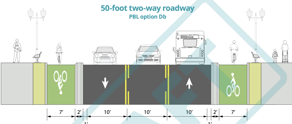
The guide also pairs cross-section examples with actual Portland streets where the designs could be implemented. The 50-foot cross-section example in the image above could be implemented on Broadway (between Hoyt and Burnside), North Denver, and on SE Foster (west of 75th). The 66-foot example is similar to current conditions on SE Stark between 93rd and 106th.
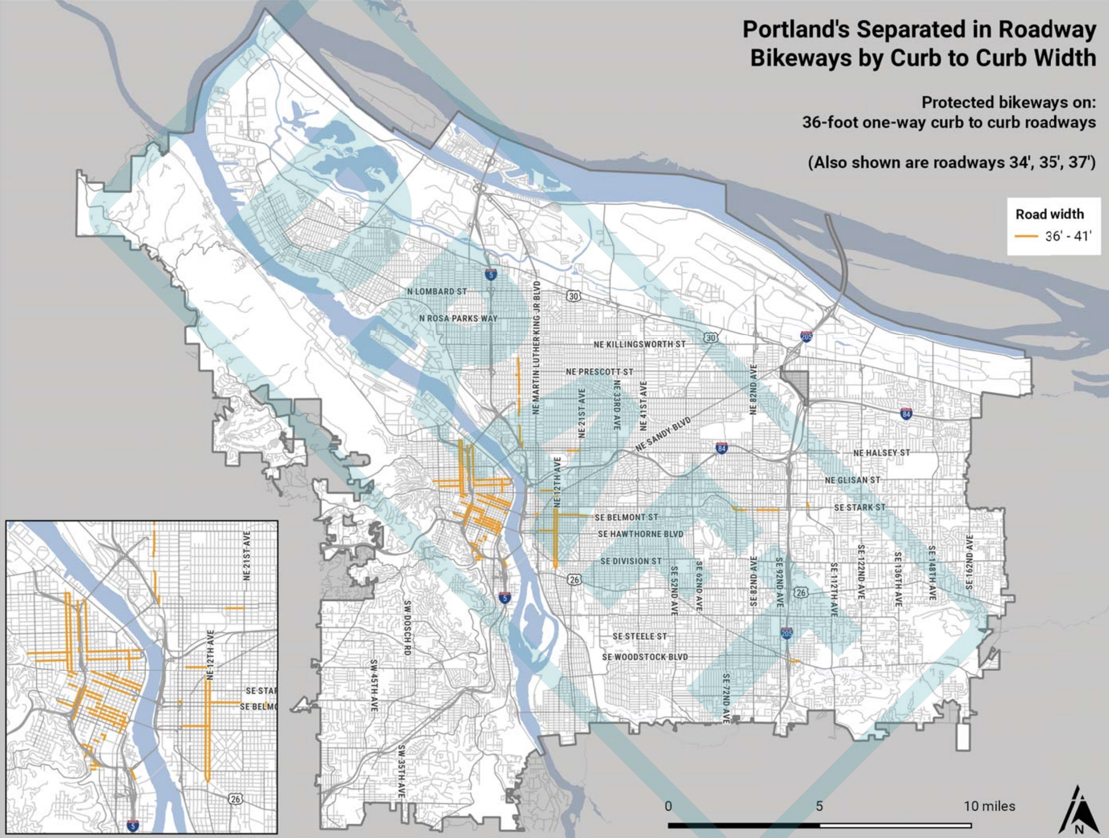
There are even map views of where the new protected bike lanes would go:
PBOT says this draft version of the guide is now out for technical review among agency partners. They’ll also take public comments through the end of July. If you have feedback, please send directly to Roger Geller via email at roger.geller@portlandoregon[dot]gov.
— Jonathan Maus: (503) 706-8804, @jonathan_maus on Twitter and jonathan@bikeportland.org
Never miss a story. Sign-up for the daily BP Headlines email.
BikePortland needs your support.


")

Thanks for reading.
BikePortland has served this community with independent community journalism since 2005. We rely on subscriptions from readers like you to survive. Your financial support is vital in keeping this valuable resource alive and well.
Please subscribe today to strengthen and expand our work.
So for about $24k you can put down a mile of posts, but do the (endless) replacements still cost $90 apiece? Say what you like about the protection of paint, but at least it doesn’t lie.
Though it does disappear. Fast.
Ugh, the terrible NACTO guide on “all ages and abilities” that isn’t rears its head again. That NACTO guide is going to do more damage than just about anything else I’ve seen recently. Unprotected bike lanes (and some designs of “protected” bike lanes) simply cannot be All AGes and Abilities.
Also missing from the discussion – any sort of intersection design treatment. Most of the protected bike lanes installed in the US fail this quite badly – their intersections simply aren’t protected enough.
Just like Vision Zero right? Why strive for an unrealistic goal? Why even have goals?
Better to just kiss gov’t engineer butt, eh?
NACTO’s biggest failure is to provide facility designs that accommodate both novice and experienced cyclists without compromising the experience for either; not to mention the whole ignoring the intersection thing, which is where the designs proposed will either ultimately succeed or fail.
If there’s one thing critical for them to focus on, it’s intersections. We’ve had to hand-hold to address issues on an intersection-by-intersection basis here in Santa Clara as they’ve extended the San Tomas Aquino Creek Trail. We convinced them to lower the concrete so cyclists and drivers can see each other coming up to Cabrillo, they took out the slip lane (which are slowly disappearing near schools due to pedestrian safety), only to shunt bikers mid-block into the busy El Camino Real slip lane a block further down (https://goo.gl/maps/PAgQj7fyS9u).
(I navigate El C intersection by timing gaps and jumping the curb early to move from trail into shoulder where I can be seen. Used to just ignore the trail segment and ride the shoulder, but they turned it into a lane because, of course, now bikers have their own path just for them (and strollers and dogs and distracted walkers)).
The intersection I live near is Homestead and San Tomas where, once again, it appears they’ll keep the slip lane and shunt cyclists and pedestrians midway into it – where drivers will be looking left instead of right to time oncoming traffic gaps.
CB,
All ages and abilities means anyone biking would feel comfortable there, not that everyone who bikes should be there. They are not high speed bike facilities.
Protected sounds nice but when do we start talking about maintaining this protection? Do we really think that they are going to provide more maintenance positions to fix segments that get removed (whether by a snow plow, semi, or distracted driver) or maybe when the glass recycling truck picks up the can and glass gets dropped into the lane? I have zero interest in not being able to get out of the lane when the lane either has debris (glass, nails, the green sewer drain guard or potholes). Is the city willing to buy the machines required to maintain sweeping the lanes? They currently have 1 but even it is oversized per the night shift manager Ryan. And even then they only budget 4-6 sweeps a street a year. Ryan also mentioned that he doesn’t currently have any positions in the budget to drive the machines that they don’t even own yet.
Maybe we can get Ted to tax more businesses to provide for these unfunded positions like he just did for more people to pick up trash downtown?
Coming soon to a ballot near you: $35 Transportation Tax.
Maybe the DMV will get serious about reeducating motorists regarding cyclists rights, maybe the PPB will get serious about protecting cyclists rights and maybe we can get the DA to enforce the vulnerable user laws, LOL!
We have to separate with curbs and planters or other larger barriers. My last ride down Better Naito showed me that the candlestick plastic posts are no match for bad (average?) drivers. It was only one month after going in, and many of them are destroyed/missing at key intersections, which confuses drivers. It’s going to be a losing battle for the City to keep up with the maintenance of those candlesticks if they’re over 137 miles of roadway.
100% agree. The number of times those wands are ran over and dislodged on the 22nd bridge over I84 is ridiculous. It used to be part of my commute, and every week at the very least 3-5 wands were missing or just laying around. Several times I counted something in the neighborhood of 10-15 missing wands AFTER they had already replaced them. I would really love Bike Portland or some journalist to get to the bottom of how much it has cost the city to maintain those wands and what percentage of them have actually survived without incident since the initial construction.
I suspect that there are a few (not many, but it doesn’t take many) knuckleheads driving pickups around in the wee small hours (perhaps after imbibing) who think its funny to drive over them. Those plastic wands will not likely do much damage to a pickup, especially if it is already a bit of a beater.
You should have seen it when they were temporary bollards. I moved/fixed/rebuilt an average of two per trip down Naito those two summers.
MH,
The preliminary concepts for Better Naito identified islands that would need to be shortened to permit unencumbered truck access to Naito in the remaining lane. I’m guessing this seasonal temporary installation did not do those modifications.
It seems like protected cycling guidelines are always behind the times. The current ones are based on the drivers of yester-year who still had a modicum of restraint, skill and judgement. The paint and candlesticks are no match for todays gadget-addled wazers who seem to think they are driving in a video game.
Another piece of context: We could do 137 miles of full concrete median (rhe deluxe version) on for less money than ODOT wants to spend on a quarter of a mile of I-5 widening at the Rose Quarter.
This Guide lacks any discussion about what happens at intersections and how one deals with driveways.
Complete failure right there.
In my previous story on the guide I addressed that issue:
What’s the point of developing/refining/implementing the treatment of the least problematic portion of the bike lanes while ignoring the most dangerous, most critical portion (intersections)?
What types of crashes will be prevented or minimized by protected bike lanes? I think it’s pretty much confined to rear-end or sideswipe crashes where a cyclist is struck by a motorist “drifting” into the lane. How many of these are there in Portland?
Compare those crash types to the right-hook and left-hook crashes. Will the protected bike lanes help those at all? Will the protected bike lanes make them worse by moving the cyclist out of the line of sight for the average motorist?
J_R,
Just because intersections are not in this guide does not mean PBOT is “ignoring” them.
We could easily make pedestrian/bike….multi use path on most streets by just using the space for the sidewalk on one side of the street and the bike lane on both sides for a protected, off street, multi use path…without loosing a lot of space from the street. I mean we already use most of that space for bike and pedestrians right now, with painted strips and all separated from each other…put them together and voila you got a off road path without loosing lot’s of street.
It shouldn’t be all that complicated, they do it in Europe all the time
Has anyone else seen the most recent example of new protected bikeway or cycletrack on the 40-mile loop where N. Lombard meets N. Columbia (PS this is not the ODOT controlled part of Lombard, but the City controlled section N of the STJ Bridge)? City just completed about a 1/4 mile section of brand new concrete protected cycletrack, here out by N. Burgard St, which will be a much needed sidewalk in a place where no sidewalk had previously existed. In the process, they have now scrubbed off the painted bikelanes that had previously partially covered a section of this route.
But, this protected cycletrack, being on only one side of the road, requires the southbound cyclist to cross the same very busy road that the path is “protected” against and then cross it back when the track ends (N. Lombard here with lots of freight traffic). So over this 1/4 mile section, the rider must wait through one light cycle, cross a bunch of lanes like a pedestrian going from one island to the next, take their life in their hands against a right-turn yield merge at the bottom of a hill full of freight traffic, in order to cross over to get to the path. Then, while riding along the track, they have to wait at a driveway to an enormous trucking operation (one of those little 6-inch stop signs tell you that trucks will run you down if you just ride along the cycletrack) – crossing this dangerous driveway nexus of several angles of trucks entering/exiting this private business from N. Lombard. This freight driveway is also difficult to get across because the trucks are already coming at or turning into this driveway at speed and their previously existing stop sign and inherent yield to bikes in the road has been removed while the city has indicated now the turning trucks will have a right of way to run over any cyclist on the path or at least block the cycletrack while they wait to pull into traffic. At the southern end of the cycletrack, the path ends abruptly at a narrow overpass, where you are dumped into on-coming traffic on the left side of the road and suddenly in the land of no paint, no MUP, no crosswalk, nada. Basically, good luck, thanks for taking a detour to use the protected cycleway, and now you are on your own and on the wrong side of the street. All that work and they didn’t fix the little narrow bridge or even bother to put paint on it. I appreciate trying to fill in the gaps, but when they go to all that effort to fill in 90% of it, but stop short of the last 100′, you got to wonder.
In the past, the rider could just ride along on the right side, enjoying some bike lane protection without having to wait and cross a bunch of dangerous intersections or wait for a break from a truck driver at the dangerous driveway intersections. The new project could have widened, enhanced, and completed the bike lane on both sides of the road, but instead went for the separated treatment laid across a busy freight driveway. I think the separation is a nice idea, but it has failed terribly at the intersections and also at the driveways. Why they chose to try to make this resemble the rest of Marine drive (without the bike lanes) is maybe buried deep in this new policy document that I’m sure has already started to gather dust.
But, what I really have a problem with is not the cycletrack, per se, but rather removal of the pre-existing bike lane and at least the perception of legitmate road use for a biker. Now, with all the additional signs that the city has put up yelling at the bikers to get off the road and onto the sidewalk, freight and other speeding cars in this area will feel justified to be aggressive while passing any bikers who choose not to use the cycletrack. So much for traffic calming. Instead, the message is take the back seat or else. This protected cycle infra idea has in practice been effectively shoehorned into the weeds along with the crumbs of the new use tax. So, be careful what you wish for.
PS – in classic PBOT fashion, they laid all this nice new concrete, put up all the new signs, and then promptly closed the cycletrack and ripped up 3 different 12′ sections of the new concrete path after it was all done. I guess they forgot something. So, now we don’t have the new facility, and we don’t have the old one, either. At least the main travel lanes have been repaved, so we have smooth riding if you take the lane, but obviously, now more at your own risk than ever before.
Is there a map showing all of the protected bikeways together, like in the slide on the previous article about the study? It seems odd that they included 17 different maps of the individual islands of segments of the various widths but not one map showing all the segments/widths (unless I missed it).
What is a good intersection design?
I mean, one short of the elaborate Dutch intersections (that don’t fit in our ROW or budget) or signals with bike phases (since you can’t realistically signalize every intersection).
https://goo.gl/maps/6ktRt6iUss52 😉
The link to the draft document no longer works. I can’t find a final version via search engine or PBOT’s site. What happened?