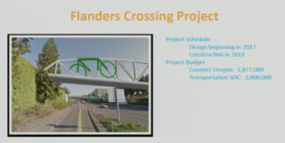
On Wednesday Portland City Council accepted a $2.8 million grant from the Oregon Department of Transportation to build a new carfree bridge over Interstate 405 at Flanders Street.
It was the final funding hurdle for a project that has been hoped-for in Portland planning documents for over 20 years. At the council meeting, PBOT Commissioner Dan Saltzman said, “This has been a long time coming.”
Saltzman is the only Council member remaining from a 2008 effort that would have recycled the old Sauvie Island Bridge for use at this same location. That project had broad support, but fell victim to politics when it was labeled a pet project of Commissioner (and mayoral candidate) Sam Adams. His opponent in the race Sho Dozono (and his major supporter, former Mayor Tom Potter), used the Flanders project as a way to symbolize what they felt was Adams’ lack of fiscal responsibility and empathy for east Portlanders. In many ways, the 2008 debate over this project was the beginning of the transportation equity argument that persists today.
My how things change.
Wednesday’s discussion at council could hardly have been less controversial. The only peep about that contentious past debate came from Commissioner Chloe Eudaly. Prior to voting in support of the bridge she said, “This almost makes me wish I lived in Northwest Portland… I do hope we can bring the same kind of innovation and resources to neighborhoods outside of the central city.”
Speaking of resources, the total cost of the Flanders Crossing Bridge is estimated to be $5.9 million. For historical context, Adams’ novel plan to re-use the old Sauvie Island bridge at Flanders was estimated (at the high end) to cost almost the same amount — about $6.2 million in 2017 dollars. It’s a bargain at that price especially when you consider PBOT models project 9,100 average daily trips over the bridge by 2019.
Advertisement
This time around the funding sources are a combination of Transportation System Development Charges and this ODOT grant via the Connect Oregon program.
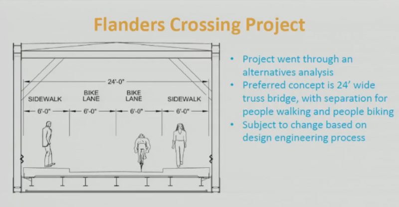
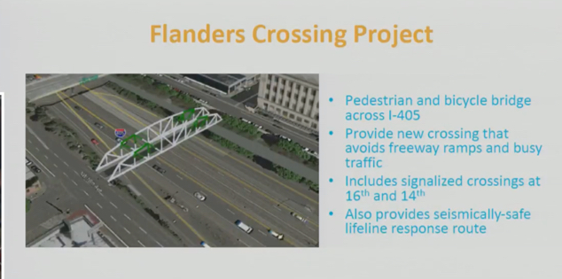
In addition to a 24-foot wide bridge with two six-foot bike lanes and sidewalks in both directions, the project will include two new traffic signals and changes to adjacent streets. Here’s what to expect beyond the bridge:
- A new signal at NW 16th and Flanders
- A new signal at NW 14th and Flanders
- NW 16th will change to a single vehicle lane north of Glisan. At Glisan people will be forced to either turn right (west) or continue straight toward Flanders.
- PBOT will install a median on NW 16th between the western most lane and two eastern most lanes from Glisan south to Everett. There will be a gap in the median at Flanders for bridge users. The median will prevent people from using the western through lane to get onto the I-405 on-ramp at Everett. It will also prevent people in cars from using the western most lanes once they get into the southbound through lane at Glisan.
These signals and other changes speak to the bridge’s role in the Flanders Street Neighborhood Greenway — a route from the Waterfront to upper northwest Portland that will be prioritized for cycling and walking.
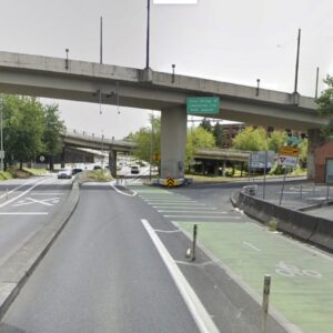
The crossing of I-405 has been the missing link in that greenway for many years. PBOT Planner Zef Wagner said at council on Wednesday that, “I-405 has divided the neighborhood ever since it was built. It’s a trench cut through the neighborhood.” He also compared it to the carfree Tilikum Crossing Bridge over the Willamette River, saying the Flanders Crossing will cross a “river of concrete.”
PBOT expects to finish the design and plans for the bridge by January 2018. Construction should be completed by April 2020.
— Jonathan Maus: (503) 706-8804, @jonathan_maus on Twitter and jonathan@bikeportland.org
BikePortland is supported by the community (that means you!). Please become a subscriber or make a donation today.



Thanks for reading.
BikePortland has served this community with independent community journalism since 2005. We rely on subscriptions from readers like you to survive. Your financial support is vital in keeping this valuable resource alive and well.
Please subscribe today to strengthen and expand our work.
The median on 16th is a great idea. People will often exit I-405 south and then cross 2 lanes to make a right onto Flanders. The median will force a much safer, 3-lefts maneuver and put them onto Glisan westbound. This will greatly reduce cut-through traffic on Flanders and eliminate this unsafe movement.
That’s exactly what the purpose of the median is. The current situation is a disaster and has been so for ~40 years. Only needed a “bike/ped” project to fix the mess ODOT created.
So are they actually going to design it or are we going to be stuck with that architectural embarrassment they are showing?
Yes, holy crap that render is ugly, not to mention tacky. I sincerely hope it’s not the final design.
Guys, it’s a concept, not a design. Design hasn’t even started on the bridge. The grant, which includes money for design, was literally just accepted by City Council.
There must be a way to make a truss bridge more attractive than that.
Make it out of marble. Everything marble.
I feel like the roar of the highway underneath would make it hard to enjoy the bridge being pretty.
Yes, we wouldn’t want to ruin that beautiful urban freeway with a boring truss bridge.
Why not put a cap over the 405?
Great idea. That would be another Portland landmark and a huge development benefit for that area. I guess you couldn’t build that for 6 million.
ten? times as much?
http://www.latimes.com/local/california/la-me-freeway-capping-20141213-story.html
http://www.dot.ca.gov/dist11/departments/planning/planningpages/capstudy.htm
$$$$
Must be a better use for $300 to $500 million.
I wonder if you could get developers to pay for it? That would be some pretty prime real estate.
Even downtown land isn’t worth that much!
And if the cap is developed with a commercial project, then there’s little/less public benefit from it (notice artist’s renditions always show a public park).
I just don’t think capping the 405 will make sense until downtown Portland is as dense as Manhattan . . . It’s just a pipe dream.
The problem is people are viewing this as two options, cap the 405 or live with the mess we have. The real options should be remove the 405 completely or cap the 405. Either the 405 drives economic activity worth capping it for or we should just remove it.
Or spend $300-500MM on Gateway, 82nd, Sandy, other areas that need it a lot more.
You could argue that housing is a public benefit.
The kind of housing that will be built on a capped 405 is a public benefit like a Mercedes S-class is a public benefit.
Public benefits from new housing over I-405:
Would provide new housing in a growing city without having to demolish anything or displace anyone;
would reduce the amount of noise at the surrounding streets;
would create a significantly nicer experience for pedestrians walking east-west;
would generate property taxes where none is being generated today;
would be required to include affordable units in the development (or pay into a fund used to build affordable units); and
would be required to meet BES stormwater requirements, which the current freeway doesn’t come close to meeting.
When capping I-405 was studied under Vera Katz in 2000 the cost was estimated at $6.4 million a block. 17 years later the cost would undoubtably be higher, but so is the value of the land. I don’t think it would be insane to take another look at the economics of capping I-405 between SW Alder and Taylor.
This really is good news. I suspect some folks–not me–put in a lot of work that led to this result. For me, though, the biggest obstacle to biking to and around the NW area is getting there from the Steel Bridge. Crossing Naito is pretty hairy and using the Hawthorne, then going thru downtown, isn’t so great. What’s happening with that?
My plan, until they get that fixed, is to ride over the top of the Steel (which I already do, currently), then take a left on Broadway and a right on Flanders.
I sure hope they signaling the crossings at 23rd, 21st, etc. Otherwise, it’ll be much less useful as a commute route.
I meant “signalize.” That’ll teach me to invent words.
Agreed. Tried NW Flanders between 16th and 23rd to get to Washington Park @ 24th and Burnside and found it was less stressful and the same time to go up Johnson.
Is the traffic on 21st & 23rd that much different at Flanders than it is at Johnson? I take Johnson now, and always have to wait for a few cars to go by, but I’m not sure that putting a light there would make it go any faster. Though I suppose there are probably times of day where the traffic on 21st & 23rd is constant (sigh).
Actually, full signals (without any diversion) would likely make Flanders less – not more – appealing for bikes because signals tend to attract motorists trying to cross busy streets. Something like RRFBs or hybrid beacons would cost less and make the street less conducive to cut-through traffic.
But I would argue that there should be at least one traffic diverter along Flanders in NWDA somewhere.
A good bikeway should have limited stops, and diverters for motor vehicle traffic. I currently use Johnson & Couch frequently for their low-traffic nature, but Couch has a stop sign or a traffic signal on every single block, and Johnson isn’t much better.
It’s primarily an issue of pedestrian safety. The stop signs help prevent drivers from gaining excessive speed along those streets. First of all, Couch and Johnson currently don’t have any diverters except for one on Couch at 15th heading westbound. Those streets have stop signs on most blocks because they traverse through a relatively dense, mixed-use, urban area, and there is way more pedestrian activity on those streets than you’ll find in a mostly homogenous, single-family residential neighborhood like Going or Clinton (the two streetcar-era nodes at 21st and 26th being the exception).
Yeah, I know, we only give priority streets to cars. We’re not going to have a web of efficient bike/ped-only routes criss-crossing the city anytime soon. That would be crazy.
Great! This leaves money for more paint and diverters on SE Clinton!
Thanks ODoT/ CoP! for working to fix old flaws…and at a cost of only 3 cents per trip (based on 50 year lifespan before assumed next major renovation)!!
PS. where is the space for the food trucks discussed back in 2008? (CPTED: eyes on the bridge)
This is a man made obstacle. Cost per trip should be figured by the number of cars that go under it, even though they are freeloading.
And remind me: what was the discussion about combining the walkways to one side?
Yes, I’d certainly like to see the 24 feet divided into one eight foot sidewalk and two eight foot bike lanes. It looks like whoever did the current drawing is thinking of this like bikes are miniature cars.
Probably want pedestrians on either side of Flanders to be able to cross the bridge without having to cross Flanders, as they’d have to do if the bridge had only one sidewalk.
Then they should widen the bridge. As it stands, it is a plan for failure in the sense that if PDX ever gets reasonable numbers of people out of cars and onto bikes, this sort of thing becomes a pinch-point. Time to build like we’re serious about our goals, imo.
Makes sense. 12′ bi-directional doesn’t seem wide enough for the future.
Bikes are miniature vehicles (cars). The design is exactly as it should be.
Exactly. If they merged the two sidewalks into a 12-foot one, I can bet that many cyclists would use it, as well as their own 12-foot lane. 6 feet wide deters cyclists.
but the bike lanes are also only 6-feet wide; will this deter bicyclists? FWIW, I think all of the widths are too cramped and small. If this is successful, it will need to be widened. It is a tight fit to walk side by side ona 6-foot sidewalk with girders on one side and a 6-inch drop on the other
> PBOT models project 9,100 average daily trips over the bridge by 2019.
Is this true? Past coverage has said 9,135 in 2035, and I believe that estimate is assuming upgrades to the entire greenway corridor from the river to 24th.
https://bikeportland.org/2015/12/04/169682-169682
A third of that, 3,045, was the estimated usage at opening in the Connect Oregon application.
Also, does anyone have a report from PBOT that shows those projections? I went looking but couldn’t find it.
It’s in the ConnectOregon application, which I think you can find somewhere on ODOTs website.
You’re correct, the 9000+ number is projected use in 2035, not opening day.
I miss Sam Adams. That’s all I got here.
I don’t.
This is one good thing he left us…but Adams was more of a visionary than an administrator/executive. He really was not a good mayor, but he was an exceptional long range planner.
That may be true, in my simple mind Portland seemed to be headed in a better direction with Adams around. I’m just a daydreamy Pisces though. I wanna think he wouldn’t have let developers run roughshod as we have seen. What do you think, if say his situation hadn’t even tainted by controversy ?
Could be a lot prettier.
Given that it has taken 9-20 years to get the needed funding, the real question is, when will they build it? Will the over-privileged Uptown/Pearl get it right away, or will it be delayed like other projects outside the central city? East Portland projects have typical delays of 5-7 years between full funding and project completion by PBOT. Cully Blvd took 15 years, while the Gibbs crossing took about 48 years.
PBOT sold the project short. It’s actually been 44 years since the idea of a Flanders bridge first appeared in the 1973 Downtown Plan. And luckily there are thousands of jobs in Northwest, so even people bike commuting from East Portland will be able to potentially take advantage of this investment.
The “delay” you speak of is usually just the normal timeframe of a federally-funded project. For example, the recent STIP Enhance round had grant applications due in 2015 for the 2019-2021 STIP. That means that from grant application to construction is six years. That’s just the normal way that federal funding works. It sucks, but that’s the way it is.
The Flanders Crossing is not federally-funded. It’s all state and local money. So it can happen faster, potentially within two years.
Yes, I agree it can happen sooner rather than later, but will it?
FYI, most STIP funding is now mostly state rather than federal, which has been declining for years. Most projects after they have received full funding are delayed 2-5 years by the NEPA process, then by design and engineering (2-3 years), then construction (1-2 years). It does help that there is an actual plan in place, as well as a lack of local opposition.
That was also my first thought seeing this. Since it’s a bridge for walking and cycling, there is no reason to have the walking part split into two. If the walking part was clustered on one side then folks could walk five abreast while still allowing others to walk around them.
Or bikes to use the sidewalks?
What about Brewcycles using the bridge? They are popular in this area. If one of them is using the bridge, the entire bikeway is blocked. I say just keep it all at a single grade and use paint to delineate the preferred biking and walking paths.
Why would this work if it doesn’t already work on outer Powell? How is a blind person supposed to see lines with their canes?
Exactly. Why is this not obvious?
So, zero gas tax is being spent on this infrastructure we wouldn’t need if not for the car-only highway it crosses? Sounds like drivers not paying their way. They need more skin in the game.
That’s a truly lovely comment. Thank you.
❤️
I’m happy to see the project, but SW Scholls Ferry Road is in greater need of a safety / stormwater management overhaul from Sylvan to the Washington County line.
Exciting!
This is an A+ project in many ways – I love it! I’m wondering if anyone will use it for bike commuting, though? Everett and Glisan will still be much faster than Flanders.
I think this is primarily a ped bridge and I hope the design discourages high speeds for cyclists.
I will definitely use it for my bike commuting. Glisan is terrible, especially approaching and crossing the on-ramp and then again at 18th where the bike lane disappears as you’re pushing up-hill. Everett is less bad, and generally fairly pleasant west of 17th, but still very stressful at the 405 crossing, with drivers moving to turn left and not looking out for someone on a bike, and people on bikes having to merge into traffic from the left side at 15th. As it stands, I tend to use Couch, which is often very slow, and also has a hairy crossing of 405 ramps to deal with, AND dead-ends at 19th. Not ideal.
I’ll probably take Flanders WB all the way from 2nd (at least until it crosses Naito directly), and EB I’ll likely use Everett to 17th, then jog over and take Flanders the rest of the way in. It may be a couple minutes slower than the other options, but I’ll take a slightly slower trip in exchange for not dealing with bad drivers aiming themselves at the freeway ramps.
I am looking forward to the bridge, but I hope they do not use it as an excuse to remove bike facilities on Everett and Glisan.
While some are very concerned with esthetics of the bridge, I’d rather see an inexpensive pre-fabricated bridge that could be installed quickly, possibly with provision to bolt/weld on some kind of flat metal sculpture to moderate the inevitable utilitarian nature of a bridge. It’s all very well to be concerned about esthetics when you’re spending other people’s money, but I’d rather get as much bang for the buck as possible.
There’s really something to be said about spending time in a space that’s functional and beautiful. Bang for the buck is fine and dandy, but I think we should consider building an investment for future generations. One where they can ride/walk and be proud and happy for the thoughtful effort put into their city by those that preceded their stay.
Bang for buck is everything. We are fighting over scraps here, and I would rather see the extra money spent to save lives elsewhere. If you want art, go to the art museum.
How original. Let’s not design anything beautiful. Let’s build apartment buildings in big square blocks, soviet style, go shopping in our big box stores, and have a city with no distinction or character. Sounds cheery.
It’s not like the thing has to be built from marble.
“inexpensive”, “pre-fabricated” … that spans, at least, 150 feet.
http://www.bigrbridge.com/en/home/products/prefabricatedbridges/pedestriantrailbridges/default.aspx
Thank you for the link! Very useful for estimating bridge costs and types.
Big structural problem setting a truss bridge on top of the two huge retaining walls, old Sauvie or new prefab.
The only feasible design is one that resolves vertical loads in the center median, maybe a cable stay, say half a Tilikum, but much smaller.
I’ve seen lots of comments regarding 17th being closed to car traffic. Realize that car traffic coming south on 16th via I-405 & 16th combined that would like to head west will now cross Flanders 2 times as they circle around before heading west on Glisan. I get that there is not a perfect solution. It will certainly be interesting to see how much more traffic will be backed up with the additional traffic lights in that area. Hopefully ODOT gets the timing and flow correct.
The hours before Timbers matches are going to be… interesting.