Oregon’s Scenic Bikeway program is about to shrink by 7 percent.
Since becoming an official state program in 2008, Scenic Bikeways have become magnets for bike tourists. They pumped $12.4 million into Oregon’s economy in 2014. There are 14 officially designated routes promoted by the state’s tourism board as recreational attractions and economy boosters for the communities they pass through.
But one of them, the Metolius River Loops Scenic Bikeway, is likely to be dropped off that list for an odd reason: fear that it will attract too many people.
The Metolius route is nestled in the Cascade mountains of Central Oregon north of Sisters. Riders can choose from a series of loops on paved forest roads along Metolius River with the welcoming Camp Sherman Store as a home base. “Cyclists will enjoy beautiful views at the Metolius Fish Overlook, both placid and breathtaking glimpses of the river, peek-a-boo views of Mt. Jefferson, and find great educational stopping points for picnics and hikes at the Headwaters, the Wizard Falls Fish Hatchery, and a variety of historical sites,” is how the description reads on the Oregon State Parks website.
While it’s a spectacular place to ride, its bikeway designation is superseded by the National Wild and Scenic River designation it earned in 1988. And that’s where things get complicated.
“There is an inherent conflict between the Forest Service Wild and Scenic Management Plan that does not allow for promotion of the area and the Bikeway Program that is largely based on promotion.”
— Alex Phillips, Oregon State Parks Department Scenic Bikeway Coordinator
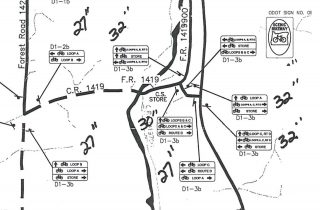
In 2013 Travel Oregon asked the Forest Service for a permit to film a promotional video of the Metolius River Loops Scenic Bikeway (12 of the 14 routes have already been filmed). That request was denied because the Forest Service said the river’s 1996 management plan doesn’t allow for filming projects that, “advertise or promote in a manner that is likely to draw visitors.” The plan also specifically calls for limits on road congestion, which could go up if the area becomes more popular in cycling circles. Another issue was the signage that Oregon State Parks uses to direct riders along the route. The river’s management plan calls for, “a consistent sign theme with the goal of consolidating, minimizing visual impact and perpetuating a historic character.”
According to the state’s Scenic Bikeways Program Coordinator Alex Phillips, the Metolius route is the only remaining bikeway that still remains unsigned — even though it was designated in 2011.
The Forest Service’s denial of the filming request wasn’t the end of the bikeway designation; but it was the start of a conversation between them, Oregon State Parks, their Scenic Bikeways Advisory Committee, and local residents and business owners.
“When it was designated in 2011 as bikeway — with a letter of support from the Forest Service — no one knew how big and successful this program would be,” Phillips shared with us in an interview last year. And in an email to us this morning she wrote, “When scenic bikeways first began, we hoped for success, but we didn’t realize just how well the idea was going to work,” she said. “Bikeways fired the public imagination, and now each designation attracts public attention and a sparks a desire to visit.”
In that regard, it appears this particular scenic bikeway might become a victim of its own success.
Advertisement
Phillips, who has been the bikeway program coordinator since it’s inception, seems resolved that she’ll soon have one less route in her portfolio. “There is an inherent conflict between the Forest Service Wild and Scenic Management Plan that does not allow for promotion of the area and the Bikeway Program that is largely based on promotion,” she wrote in a stakeholder email back in December.
That conflict was clearly spelled out in a June 25, 2015 letter to Phillips from the Forest Service. Here’s an excerpt:
“As you know, the Deschutes National Forest and Oregon State Parks Department staff have discussed ways to allow the two designations to live side-by-side without sacrificing either. In review of the Metolius River Loops Bikeway designation in the context of its consistency with land managememnt plans, we are finding that the WSR [Wild and Scenic River] and Bikeway designations are not complementing each other as desired. Some items which are difficult to reconcile with the WSR plan include reducing congestion and providing better traffic flow, managing singing to minimize visual impact and perpetuate a historic character, and not permitting commercial entities to promote the area to draw visitors.”
The letter also expressed concerns over “carrying capacity” of the area during the summer peak and it identified five roads (FS Roads 14, 1420, 1419, 1217 and 900) that are on the bikeway route but the Forest Service deems, “not designed for bicycle use” due to their lack of a shoulder, striping, speed limit enforcement, and safe sight lines.
The letter didn’t call for the bikeway designation to be stripped, but it made it clear maintaining it would be all but impossible.
Making things even more difficult for the bikeway designation is that some residents of Sisters and Camp Sherman have expressed concerns to the Forest Service about the proposed signage and the crowds it will attract.
Phillips has tried working with local proponents to iron things out. There have been several meetings to hash out a signage and promotional plan that would balance with the needs of the Forest Service plan. At a meeting last April, local bikeway proponents were given one year to finalize their plan. They’re set to present it at a meeting in April when the Scenic Bikeway Committee will vote on the designation removal.
The proponents will argue for a compromise based in large part on their belief that the Forest Service management plan is outdated and that management of the bikeway is possible. They say (in a draft we received) “due to the advanced age of the 1997 plan, it does not address the growth of, or impacts associated with, the road biking now popular in the area.”
It’s highly unlikely that the State’s Bikeway Committee will opt to pick this fight with the Forest Service. But even if the designation is removed, Alex Phillips says it’ll still be a great place to ride. “The mission of the Bikeways program is all about promotion and bringing more people into an area. If the designation is removed the roads will still be open to bikes. It would just not be in the Bikeway Program.”
— Jonathan Maus, (503) 706-8804 – jonathan@bikeportland.org
BikePortland can’t survive without paid subscribers. Please sign up today.


Thanks for reading.
BikePortland has served this community with independent community journalism since 2005. We rely on subscriptions from readers like you to survive. Your financial support is vital in keeping this valuable resource alive and well.
Please subscribe today to strengthen and expand our work.
The Oregon Scenic Bikeway program is flawed since all it typically involves is placing a few signs along a busy (often ODOT-controlled) highway and calling it a day. It would be nice if the Scenic Bikeway program came with funding to build off-street paths or protected cycleways. A program encouraging people to ride along motor-traffic-heavy Highway 101 without creating a safe space to ride is irresponsible.
Adam H.,
Of course it’s not everything we’d all like it to be. But before you call something flawed, you might want to learn a bit more about it. There’s a lot more to this program than just signs. The routes are vetted by the state and an independent committee. Local business owners and advocates submit the routes and become its caretakers. They spur tourism spending and put bikes on the radar in communities that would not otherwise usually think of them. Overall it’s a pretty great program. And yes, more funding would be great!
And one more thing… Highway 101 is not part of the Scenic Bikeway Program.
I haven’t been out on any of the scenic bikeways, so I thought I would look some of them up. I found a seemingly very dangerous intersection on one of the routes (https://www.google.com/maps/@45.5126105,-123.0913177,3a,90y,153.25h,74.79t/data=!3m6!1e1!3m4!1s_DXM4qutqaDRNG3eKqa91A!2e0!7i13312!8i6656)
This part of the route requires crossing a state highway (that has a speed limit of 45MPH) at grade with no signalized crossing.
That doesn’t seem very well vetted to me.
Once you leave the city, crossing the street without a signal is normal. I have had far fewer incidents riding 10,s of thousands of miles on rural basic rule roads with no shoulders like most of the bikeways than suburban streets.
That’s normal for the country. Have you looked up the traffic count on that road?
Apologies, it seems I have confused the Oregon Scenic Bikeway program with the Oregon Coast Bike Route. Also worth noting that something can be “flawed” but still have some good aspects.
I was not aware of the work that has gone into this program, so thanks for informing me! I do think this can be a great way to boost tourism and connect communities, however I am wary of supposed “bike routes” that are shared with motor traffic. Imagine the potential of this program if dedicated cycleways were included, similar to the Banks-Vernonia trail!
As a general rule, I think my routes are the best, but the Scenic Bike Routes are good too. Sometimes they get me to try a route I wouldn’t or hadn’t thought of. I don’t need signs, I can read an old fashioned map, but the scenic bikeways program is a way to promote Oregon as a place to ride.
Having ridden several of the Scenic Bikeways (Willamette River, Tualatin Valley and Sisters-Smith Rock, I can attest that they are *extremely* well designed, considering the lack of bike-specific infrastructure. Chosen roads are almost entirely low traffic with good sightlines and often generous shoulders. It would be difficult to pick a safer, more pleasant route in any of these regions — which is exactly the point: the route designers spend a ton of time figuring these out, so you don’t have to.
This does not make them free of difficult intersections or crossings, of course, because this is the real world, and it’s America. But I for one am a huge fan of the Scenic Bikeways program, and love what it’s done for bike tourism in the state. I’d love to see more of these, in Oregon and in other states too. The signage is clear, the route sheets are a godsend, and the outreach they’ve done with local businesses is a powerful tool for changing minds about bike tourism in rural areas unfamiliar with the idea.
My solution to the Metolius problem: why not close some of the roads to cars? Seriously.
The carrying capacity of even a narrow paved forest road is enormous when everyone’s on a bike — the only conflict comes when a few cars encounter a lot of bikes. Seems like shifting the traffic from motorized to non-motorized is a win for everyone involved, and does the most possible to preserve the Wild and Scenic nature of this beautiful part of the state (and yes, of course you could still put emergency and Forest Service vehicles on the road).
As long as they keep the Metolius-Windigo trail open to bikes
Won’t someone think of the salmon and elk…
“The plan also specifically calls for limits on road congestion”
did you mean “The plan also specifically calls for limits on auto congestion on the road”? because bikes don’t yet have a lot of congestion issues… more people on bikes usually means less people in cars, which generally means less congestion…
A bike and rider requires 1/200th the space needed for a motor vehicle. But, that involves fractions, and we all know how hard higher math is.
Bicycles cause an unacceptable increase in stream temperatures, it’s bad for fish you know.
all that hot lycra butt…
“But even if the designation is removed, Alex Phillips says it’ll still be a great place to ride.”
if the designation is removed it’ll be an even better place to ride….
This sunds a little like boltng the barn door after the horse has fled.
The people who already know About the beauty of the Metolius River Area — and there are many — have already enused about it to family and friends, and word of mouth has helped to insure that it will remain a tourist attraction for years to come, whether local residents like it or not. The fpcus should be on designing infrastructure that will control — and, where appropriate, even limit — the public’s access in order to preserve the ecosystem and lessen the harmful effects of environmental impact. Designing and planning infastructure takes a lot more time and money than simply marking a route with signage. Frankly, I would be in favor of an approach that treads more slowly and carefully in environmentally sensitive areas.
The river’s management plan calls for, “a consistent sign theme with the goal of consolidating, minimizing visual impact and perpetuating a historic character”
Minimizing visual impact… Somehow Speed limit, turn advisory and other forest service/traffic advisory/scenic signs are perfectly fine.
We couldn’t possibly add “Scenic Bikeway” to existing sign posts.
Interesting. We camped at a USFS campground on the Metolius near Camp Sherman last summer and rode around the whole area. Car traffic was really light, but they are correct that there are places with poor sight lines and narrow road. That said, lots of families out riding and it was beautiful.
FWIW, one specific reason we went camping in the Sisters area was because of the cycling opportunities — my daughter and I rode the Sisters to Smith Rock scenic bikeway one day, my husband rode his mountain bike all over, and all of us did lots of riding around Camp Sherman. Those routes brought in one family, but so did the river and the excellent camping as well — a good confluence.
Some items which are difficult to reconcile with the WSR plan include reducing congestion and providing better traffic flow, managing singing to minimize visual impact
managing the singing could be hard in such happy circumstances
Why would Travel Oregon need a permit just to film a roadway? If I do this Bikeway with a GoPro, is the Forest Service going to fine me or have me arrested. Seems odd.
Also isn’t taking it off the list because its popular just going make people want to do it more. Now its the one I want to do the most.
It’s a pity the scenic bikeways all stand alone without well-implemented safe connections by bike. This leads to almost all of the visits to them being based on car travel. In this sense, the forest service has a point; the cyclists are mostly environment-destroying motorists and the more of them come the more car traffic they directly create.
This is a depressing letter from the Forest Service.
Those paved roads are “not designed for bicycle use”?
The Wild and Scenic River plan calls for “reducing congestion and providing better traffic flow”? So we are keeping our rivers Wild and Scenic by keeping cars moving?
Perhaps the emphasis should be on people hiking, rafting and cycling along these rivers rather than only driving with “better traffic flow.”
A lot of good points have been made. I live in Bend and ride the Twin Bridges designated bikeway at least once a week, and have for over 10 years. I have not seen a gigantic increase in usage since its designation, although I can’t quantify it. I also know the Metolius area, since I have hiked out there for years. I am not in favor of creating routes that will have most riders drive their cars to do the ride. And, there are lots of four-wheelers and campers out there who drive very fast on these roads. I prefer designating routes that do not encourage driving. Traffic on Highway 20 is already pretty heavy in the summer, anyway. The Sisters area has tons of tourists already; why not create a route that needs the economic development?
The next time someone comes selling the wild and scenic snake oil. ….
Just remember how good government is at keeping people out.
The predominant history of modern man’s relationship with forests, rivers and the earth has been to rape and pillage them all to extract natural resources for the service of mankind, neglecting any environmental impacts. I am literally talking about polluting the rivers, mowing down the forest and carving deep the land, damaging all for centuries.
At times, however, this newer sensibility of treading lightly on sensitive lands, while an meritorious concept overall, galls me as an extremist overreaction, wherein now we can’t even transit a bicycle through such an area, but motor vehicles, quads, atvs and highways continue unabated.