One of the big obstacles to biking in south-southeast Portland has once again been bridged.
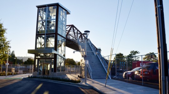
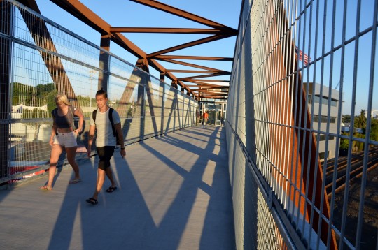
Along with the opening this weekend of the new Orange MAX Line and the Tilikum Crossing, TriMet opened a new Lafayette Street pedestrian bridge across the Union Pacific Railroad tracks in the Brooklyn neighborhood.
It runs from approximately 18th to 20th avenues and connects Lafayette Street, east of the tracks, with Rhine Street west of the tracks.
Though nothing could be as seamless as the tracks not being there at all, the new $3.9 million bridge is a vast improvement on the rickety 70-year-old one it replaced.
As TriMet explains in its official news release, Union Pacific covered $1.7 million of the cost and the Orange Line project covered the other $2.2 million. Half of the Orange Line money comes from the federal government, with the rest coming from various state, local and regional governments.
It’s the only crossing of the tracks between the major arterials of Holgate and Powell, and will be a useful link to people looking to head east or west using the bikeway on Gladstone Street, including people moving between downtown Portland and Reed College, Woodstock and Creston-Kenilworth.
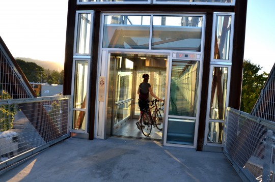
It’s certainly a sign of how much higher our infrastructure standards are than they were in 1943. Instead of creaking wooden stairs, the new bridge has a roomy, roll-in glass elevator on each side.
If you haven’t used them yet, I’ll be the first to warn you: These elevators are lessons in how the greenhouse effect works. On a sunny day, they’re very, very hot.
Fortunately, the ride is brief.
Advertisement
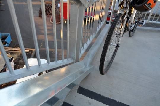
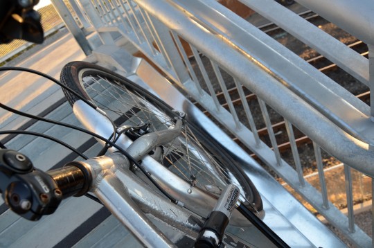
If you want to skip the elevator and are heading up the stairs with a bike, you can also use the wheel tracks on the right and left of both staircases.
They’re built with a nice wide angle, so I was able to lean my bike at a 45-degree angle fairly easily and roll it up without much strain.
Going down was another matter. At the angle required to keep my bike in the track, my bike’s center of gravity wound up beneath me on the descent. I decided it was easier just to hoist my bike over one shoulder as I usually do for stairs.
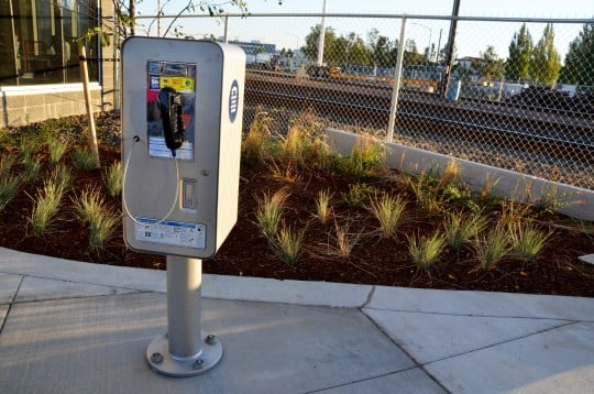
Six or seven people crossed the bridge when I stopped by early Saturday evening, and they all seemed to like the design. There are a few appealing artistic touches and even that sadly forgotten urban amenity, a pay phone:
Because why not? Sometimes you need to make a telephone call.



Thanks for reading.
BikePortland has served this community with independent community journalism since 2005. We rely on subscriptions from readers like you to survive. Your financial support is vital in keeping this valuable resource alive and well.
Please subscribe today to strengthen and expand our work.
This is a much comfortable way to get across the tracks than the Holgate sidewalk! My only issue is that the elevator doesn’t automatically change floors after the doors close. That could have been a nice touch since the buttons are hard to reach if you’re in there with a bike.
Other issue is there’s zero cycling infra on either side of the bridge, but that’s hardly the bridge’s fault.
PBOT has already drafted concepts.
It is one of my pet peeves that nice expensive new infrastructure is built without that added 5 or 10% in cost that would connect it up with everything. There are always plans, but they need to be INCLUDED. Just like the Waud Bluff Trail…..$2.7 million I think, but with just a little more funding we could have had a nice greenway connection past Lombard to the North Portland Connector.
Not that I am ever a friend of stairs and elevators. Portland has a spotty history of maintaining them and they have limited capacity. Ramps…..always prefer ramps.
Any idea how the Waud BLuff bridge got built. legally speaking? In my understanding of the ADA guidelines, this is totally not OK! The stairs could have been extended into a ramp, and the ramp may have exceeded the typically ADA requirements, but so does the trail. That is considered high-challenge. and if the grade is labelled, it provides access to active chair users, some motorized chair users, strollers, bikes with trailers, etc.
Max — a couple posts here —
http://bikeportland.org/2013/03/15/first-look-new-waud-bluff-trail-connects-north-portland-to-swan-island-84300
http://bikeportland.org/2011/11/07/steepness-stairs-will-limit-bike-access-on-new-waud-bluff-trail-61552
As I understand it (and if you read all the comments on those two posts you’ll probably understand it better than I), they avoided ADA requirements because the path is on a pre-existing roadway with a 12% grade, with no feasible way to make it a 5% grade.
This, unfortunately, also allowed them to build the stairs to the railroad bridge, rather than a 400′ long 12% grade ramp, which would have allowed wheeled human powered vehicles to have a continuous rolling surface. (I did a long rant on this tradeoff on one of BikePortland’s Waud Bluff stories, but I don’t see it in either of the two posts that Google found for me — basically, there should be some intermediary “standard” that requires the engineers to install a surface that a bicycle can roll on to call it a bicycle route.)
Ted Buehler
http://bikeportland.org/2011/09/15/work-set-to-begin-on-long-awaited-waud-bluff-trail-to-swan-island-59076
Nice rant.
Thanks for the link, lop!
Ted Buehler
We absolutely need bike lanes on 21st, south of Powell, and a greenway to the north, connecting Gladston to Clinton, passing by this bridge and the easternmost entrance to the new bike trails.
it’s funny that you get in and it says “Going up”/”Going down” automatically but then doesn’t unless you press the button. However, I’m sure we’ll all soldier on just fine.
Crossed it last week on foot! Pretty neat to again have this connection point to 17th. Pretty rare that I have a destination immediately on the other side, but this cuts off nearly an entire mile in that hypothetical (you have to head all the way down to Holgate or up to Powell otherwise). I’ll set up the Strava segment, should be a challenging one. 🙂
You might have a destination now, with the new LRT station there. This crossing is now much more useful/important, and it’s why the bike connections to it have become more needed.
Looks like a nice bride, too bad about the elevators. Anyone know why they opted to not use ramps (I am guessing it was a spatial concern).
Some great backstory on bridge construction can be found in the Sellwood Bee. Hope this link works:
http://pamplinmedia.com/sb/74-news/265564-138614-maker-of-brooklyns-new-footbridge-has-long-history-in-southeast
ADA accessible ramps can add about a $1M to a project – in addition to the space needed. The elevator meets those requirements in a much smaller footprint.
You are right of course, but to reach our 2030 bike mode share goals, Elevators are always bottle necks: they take too long and people hate them. This does give us an excuse though to Road Diet or fix Holgate in some way….. that would be the only bike connection in the region with any capacity during commute time over the Brooklyn Rail-yards.
But is it a bike connection? Isn’t it a pedestrian bridge, or is the article in error?
Yes, I am aware that people can ride on sidewalks, but no one is going to design sidewalks to the standards those people would like.
Yes, it was all a spatial concern. The original plan was to construct ramps instead of elevators. In order to meet current ADA standards, they would have consisted of a long set of switchbacks at either end of the bridge. This would have eaten up at least twice as much land area as the structure that has now been built. The surrounding land may seem sparsely used now, but this is likely to change in the near future.
What’s wrong with 1943? Technology from that era defeated the Nazis.
The Nazis were also using 1940s technology.
Yes it did and in Good Ole American style we ignored it and let it rot.
Cuz were da best!
USA! USA! USA!
My understanding is that this was an at-grade street crossing up until the 1940s (along with the one at the east end of Gideon St., and the 13th Ave. crossing. It seems that Southern Pacific wanted all three of those closed to accommodate the increased freight traffic, and extension of yard activities, and considered this a “wartime” emergency. Their request was granted, if they built pedestrian bridges at Lafayette and Gideon. The old Lafayette bridge looked like it was a used bridge they found around, which was too short, but they put piers in and put it up there, and built an extension on one end to reach it. And then, as mentioned, did little maintenance.
“It’s the only comfortable crossing of the tracks between the major arterials of Holgate and Powell…”
Actually it’s the only comfortable crossing between Bybee and Powell, which is a pretty huge swath. Holgate is pretty awful.
You’re right! I actually meant to type “the only crossing.” I’ll fix.
Heck, and I’m not even too impressed by Powell!! I mean, I use it myself on occasion, but just this weekend I steered my girlfriend away from it on her solo trip to the Aladdin. Dark + hidden + underpass + seedy gathering spot….
Powell needs a crossing at 21st like the one going in at 28th. Powell can be super scary to cross, even at a signal.
Powell has a signal at 21st.
Yes, it does; I was suggesting a better signal, like the one proposed for 28th.
21st/Powell needs its own dedicated left turn signals like 26th now has…
Unless that means no bike lanes, which, from what I’m told, would be incompatible with a left turn phase (like at 26th) due to space constraints.
There is another way around the space issue – split phasing. It may introduce more delay to the main road. You may have seen it in some locations. One direction at a time gets to go, northbound or southbound, through and turn movements. So, if the side road has a low volume, the through and left turn cars share the same lane.
That might work. I am nervous that ODOT is going to bulldoze over the neighborhoods when they redo that signal, and make the much-needed bike lanes impossible by establishing “facts on the ground.”
I hope PBOT is able get ahead on this one…
Powell needs a road diet.
I’ve crossed it a few times now, grateful for it. Links to Peoples/Bikes4Humanity and more. I did find it odd the whole metal siding was shaking pretty vigorously from a person jogging by, a fair amount of flexing I suppose.
I think it’s absolutely essential to have these crossings. But from a design standpoint they always seem to end up ugly and awkward to use no matter how much money or “design” they throw at them. I am thinking of similar exercises at South Waterfront, Sunset, Parkrose TC. And the elevators being urinals. It has everything to do with ADA and over-zealous codes. I think the pedestrian bridge over 205 near Adventist is nice. The spiral ramp from the Eastbank to the Morrison is always a treat visually and experientially thus could never be built today.
The Gibbs Street pedestrian bridge in SW is the only place besides the Ross Island Bridge that provides a public view from up-close-and-above of the South Waterfront from the west.
I rode over it last week.
Quite nice. Good work TriMet Orange Line folks, engineers, etc.
PBOT/TriMet really need some clear signs that direct people on foot and on bicycles to use this bridge, rather than the Clinton/12th grade crossing maze, if they’re going south of Powell.
Ted Buehler
According to the high school commuter, it’s still faster to ride over Holgate (on the sidewalk) and up 26th than take the new bridge to get to CHS. But I think only 2-3 minutes faster :).
This one has more clean air.
Maybe its the quick route in the morning, the nicer route in the afternoon. Thank you for bringing up Cleveland kids. This seems like an amazing improvement for all the kids from Brooklyn to get to school.
I should have added that when the high schooler takes the bus, getting of and walking over the news bridge is always the preferred choice. Though they still have to cross Powell at. 26th. 🙁
It’s not the fastest bridge.
But it’s a very nice ride.
Dozens of these bridges are needed over the many railroads around the metro area.
Also, it is great to see the pay phone there, too.
We need some bike lockers next to the phone.
Rode into and out of the elevator and over the bridge on the way home tonight. FUN!
Did you use the old bridge in the past?
Is there enough room for a spiral ramp? If so, could it manage an ADA compliant grade or not? Is the size of the site physically limited, or is it a property ownership issue which could be cured by Eminent Domain?
I’ve used the elevator at the sunset transit center to access the Hwy 26 crossover bridge. It works well enough. For looks, the Lafayette Street pedestrian bridge elevator tower isn’t bad. Glass and steel or aluminum, just like Downtown. Public outdoor payphones are kind of a rare species these days. Hope the maintenance people can keep this one fairly clean, not smelly.
it’s a nice bridge… it doesn’t connect much, but I suppose if you live in the middle of Holgate/Powell and need to get to something (what is there?) on the other side of the tracks in the middle of Holgate/Powell then it is useful… I still don’t know that I’d want to use it at night given the location’s violent history… I’d go the few blocks out of the way to Powell…
I’ll likely never use it since I’m never in that neighborhood on foot unless I’ve just walked 5 miles drunk from downtown at 2am…
I’ll never bike on it because I’m not skilled enough to bike up stairs and I hate waiting for elevators… you could bike up to Powell and back down in the time it’d take to “ride” your bike across this bridge…
Many more bridges need to connect people over railroads.
There’s the whole Brooklyn neighborhood that has been largely cut off from surrounding neighborhoods for pedestrians and bicyclists because of the railroad tracks, homeless camp in the Powell underpasses, and whatever my hangup is about Holgate. Now they have less creepy access to delightful things like People’s and New Seasons.
And bike commuters following the light rail tracks can now hop over the tracks and head up Gladstone. If it proves to be as usable a bridge as I think it is, bicyclists now have an alternative to the Clinton route to Tilikum.
All we need is bike lanes on 21st and a better way across Powell.
We need more. The whole SE railroad/99 area is a mess. It’s a desert as far as comfortable biking options are concerned. Holgate is terrible. It’s one of the few areas that cause me to just throw up my hands and say, “Screw it, I’ll just drive.”
this light rail project should have budgeted many more of these bridges
European cities incorporate heavy rail (and they have a whole lot more of it than we do) very differently than we do here. No at grade crossings for people in cars, bikes, or walking. Personally I think that a worthy goal (for the wealthiest country in the world), but I’ve never seen it discussed here.
In Wuppertal, where I used to live, they just put the train in the air. But in all other cities they figured out less drastic solutions.
http://www.schwebebahn.de/en/history-technology/history/
The schwebebahn is pretty cool to ride, and a marvel to behold, but it didn’t do much for the river beneath it. But maybe that could be how Trimet can get their bus rapid transit to work on Powell.
“The schwebebahn is pretty cool to ride, and a marvel to behold, but it didn’t do much for the river beneath it.”
Do you mean the noise? Say more.
The noise, the shade, the general industrial feel it brings to the river (though in all fairness, that river was long a dumping ground for all sorts of delights from the textile industry and others).
I will admit that it does bring a certain retro steam-punk sensibility with it that’s kind of unusual these days.
Retro, steampunk… that’s good.
Can we use those terms to refer to something that never went away? 🙂
It’s been mentioned before and will not change this bridge but…stairs and elevators are lame. Elevator malfunction, start to smell, get lived in, are easy points to be ambushed in…etc. Stairs are almost as bad. People fall on them (up and down), get quite dirty, difficult to traverse with small kids, sucks to bike gutter….etc. Ice forms on them quite easily. Stairs create a visual barrier. This bridge will require a larger ongoing maintenance budget over time.
Ramps solve all this. They are easy to clean, are welcoming, can be traversed by everyone, little kids are not in danger, require no mechanical solution. Everyone from 2 to 102 can handle them. Cannot be ambushed on. Fun!
I hope this is Portland’s last stair bridge. It’s cool today..but will look horrible over time.
Many, many more bridges are needed over the many railroads in Portland.
DITTO DITTO DITTO. This solution requires gobs of energy and regular maintenance. All to do what numerous ramped bridges around town do without any energy and practically no maintenance. I like that the city is looking out for handicapped people. . . but the end result is that we’ll have to wait for the car to arrive, then stand in puddles of pee when we get in, unless it’s out of commission, then we’ll have to walk up the stairs anyway while the city rushes out a contractor to repair it for a hefty fee, then do the same on the opposite side. It’s a slow, highly over-engineered, un-resilient system that is subject to ill effects from social disorder (homelessness). Boo.
Love having the bridge there. Have used is several times and generally like it a lot.
Had to use the wheel track to get down today as the call button on the elevator wasn’t working, and I agree they are really bad when coming down. With panniers on the bike, you have to lean it at a pretty crazy angle as the track is right up against the hand rail, and it’s all pretty unwieldy. I could well see someone less mighty and heroic than myself starting gamely off down there and ending up dropping their bike down the stairs.
Call button wasn’t working. . .
Expect more of this. :\
Yeah and with a kid on the back of your xtracycle, the stairs are probably about as hopeless as the ones at SW Gibbs. Even with electric assist, the handrails / bike rails are in the wrong place. Seems like they could at least make one side work for ADA and one for bikes.
http://zacharyshahan.com/6-groningen-netherlands-great-bicycle-city-photo-tour/2/
This has completely changed my commute from one that was full of aggravation and hate to one that is so comfortable that I have been forgoing the use of my gopro. I will probably never bike clinton st again if I help it. My commute starts at SE gladstone and 39th and goes all the way to 2nd and Stark. I have to use a total of 5 city blocks of shared road space with cars now thanks to this bridge and the tilikum crossing.
This bridge coupled with the tilikum has been surprisingly enjoyable for my commute. The only real pain now is the SE 11&12th crossing that is full of crazy. Yesterday would have been 100% blissful if not for some driver screaming out her car window at a trimet worker to “Fix this %$#@!” as she let her horn blast the whole time. The number of issue with that crossing is too much for this short comment but we still have plenty of work head if we want the 17th connection to go to the tilikum smoothly.
Also I would like to note that the bike wheel tracks are horrible IMO. I used them once I don’t see a reason to do that again.
Slightly off topic but I’ve had success going 2 blocks N on 12th from Clinton to Caruthers, and then taking the 8th ave crossing over Division & the tracks. For bonus points DON’T take the “Tilikum Way” path along the Max tracks, but Division PL under 99E to 4th.
Which is a long way of saying the eastside connection from 12th/Clinton to Tilikum is pretty good if you ignore the wayfinding paint & signage.
They got rid of, and didn’t replace, the pedestrian crossing at 16th and Brooklyn.
Also demolished the skater-created skate park at that same location for apparently no reason at all, as the light rail tracks are not that close.
Trimet repeatedly promised to replace that bridge if there were funds left over. The project came in under budget, and… still no bridge. (And no skatepark, sadly.)
Did the old bridge at SE 16th and SE Brooklyn Street cross over the railroad trails to get to SE Gideon Street?
Yes.
What did the neighborhood and SE industrial area say about that? That is not acceptable to remove a pedestrian crossing like that.
I think the neighborhood (NA, residents, pretty much everyone) is pretty pissed, and are working to get it back.
A new one needs to be built. The light rail corridor on 17th forces pedestrians to walk farther to get around compared to the old street.
This bridge enables a new preferred route from the SE 26/28th – Gladstone area that avoids having to cross Powell or use Clinton or Ladd by enabling connection to the new Orange line MUP. The old bridge was usable to cross here into Brooklyn, or cross Powell on 17th, but this only meant you still had to get through the zone around 10th and Woodward. (I used to access the Ross Island bridge to get to OHSU from Brooklyn neighborhood by running across the tracks at 17th and Tibbets, before they put up the fences). Plus the old ped bridge was kind of scary and decrepi. It’s only since the new MUP is in place that there is more reason to use this bridge.
I think a lot of folks are still biking across Powell at 21st or 26th to take Ladd, since the MUP cluster does take some getting used to. 21st/Powell still needs a left turn light the same as 26th/Powell received. Then there is also the option of going under Powell on the old sidewalk on the south side and circle back to the new MUP.
Stairs here on the bridge are a bit of a problem, as they are quite a short stair width and also steep – so when you have to carry your bike with weighted panniers or racks down these steps, it is a bit dicey – and, as mentioned, the wheel gutters are barely usable.
Somebody mentioned air quality – I crossed this bridge yesterday directly over the top of a parked, idling Diesel Locomotive. Not good air quality at that moment!
Area safety improvements on this whole east side approach from SE Gladstone and 26th to here need to be made. Hopefully PBOT can do something about it: bike lanes on Gladstone; restrict parking on 22nd from the UPRR Gate to Bush street – especially near the blind corner at Gladstone; marked crosswalks of SE 22nd at Lafayette St and perhaps some better traffic control at 22nd and Bush. This is a bit of an industrial area and also a cut through area for cars, and cars like to speed through here and drive like they own it. More bike traffic is coming.
Heading towards downtown over this bridge is pretty good, and it works pretty well connecting with the MUP. Coming back the other direction has some problems connecting via the new Infrastructure on the West side of this elevator bridge: approach to Rhine St from the West/North side on the MUP leaves you salmoning upstream in the bike lane on 17th or riding on the sidewalk. The crazy “Z” crossing over the Orange line tracks at Pershing with railings sticking right out into the path and no room for maneuvering – plus having to turn your neck way back to check for trains at the same time as turning your bike through here is not fun. But, I guess Tri-Met designed this so that you come off the MUP and are supposed to cross 17th at the crosswalk on Pershing (this has it’s own issues since the Jersey barrier makes visibility difficult for cars speeding down the offramp of Powell), ride up 2 blocks to Rhine st on 17th, wait at the traffic light to cross back to the same side of 17th you were just on and then roll to the elevators. I am pretty sure that’s the “official” route as designed.
Can the wheel gutters be placed in the center of the stairs instead of at the edges?. Is that too much of a falling hazard for pedestrians?
One oddity about the elevators is that they have “door” and “rear door” controls. Which one is which? I could tell but that would be cheating.
The bridge is fantastic – use it daily on my bike. It’s roomy enough for a cargo bike, or bike trailer, and is fast too (some elevators seem to take FOREVER). It also has a lot of CCTV.
I agree the infrastructure now needs to be rolled out around it. Particularly to the east. Fred Meyer Corporate (huge office, thousands of employees) is two blocks from this new bridge and the MAX stop. Yet auto traffic on SE 21st and 22nd – the streets you cross to reach corporate from the bridge – is insanely unsafe. It’s all cut-through traffic trying to avoid SE 28th & Powell.
I hope they extend the amenities for pedestrians and bikes to at least Freddies. Bikelanes on 21st! Stop signs at 22nd! Nothing major – just a tin of paint and a tin sign on a pole.
C’mon Portland!
What would platinum do?
What did you think when using the old bridge?
For about a year I lived in Sellwood and worked at Bullseye Glass just off Lafayette. Basically every day did I cross that bridge more than once, and often in the middle of the night. In those quiet times it became a favorite aspect of Portland. I’m sure it wasn’t so accessible or comfortable for many others, though.
Sweet! It’s already showing up on Google Maps as a route!
The old bridge was in the same area.