After months and months of draft renderings from the team behind the planned expansion of I-5 between Washington and Oregon that focused on the highway, on Thursday the public finally got a look at what a potential bike and pedestrian path being planned as a part of the project could look like.
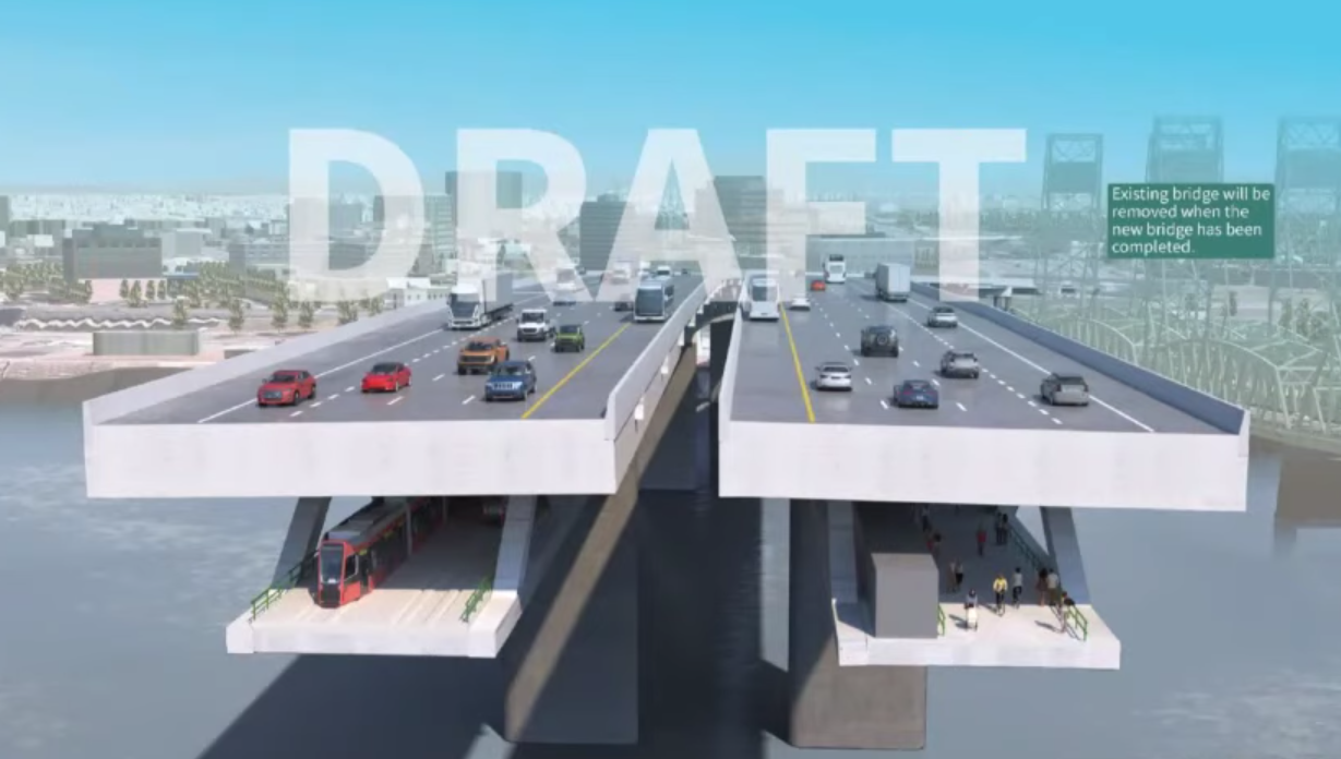
At a meeting of regional leaders, the Interstate Bridge Replacement project team showed a rendering depicting twin six-lane bridge structures, including shoulders, with a light rail train below one of the structures and a bike and pedestrian path below the other. Bizarrely, both areas below the highway are shown in darkness, with no lights depicted on renderings of people using the multi-use path. This has the effect of illustrating how little natural light would reach the path. About a third of the area available below the highway next to that path is shown taken up by mechanical equipment.
It’s not yet clear what the need might be for mechanical equipment underneath the bridge that could take away space from the walking and biking path. During the meeting, IBR program administrator Greg Johnson noted that the project team was in talks with US Senator Jeff Merkley about including a “smart highway” concept in the design that could include electric vehicle charging capabilities for drivers traveling at “freeway speeds.”
Portland Commissioner Jo Ann Hardesty pushed back on that concept. “90% of the people I know will never be able to afford an electric car, and so if we’re going to be increasing the cost [of the highway] significantly so that people who can afford electric cars can charge it on their way to work, I think we need to have a conversation about that, because that’s an equity issue that would severely impact some populations at the expense of others.”
The rendering doesn’t show any of the approaches to the shared use path on either side of the river, with those still depicted as a generic 3D circle in project renderings. Earlier this year, immersed tube tunnel advocate Bob Ortblad made his own calculations to depict what those ramps might look like. But those drawings drew direct criticism from the project, even as they have not been able to provide their own. That may be partly due to the fact that negotiations with the US Coast Guard are ongoing, after an initial analysis suggested that the IBR design was 60 feet too short to receive Coast Guard approval.
Johnson was emphatic in noting that the rendering shown Thursday is just a “draft concept.” “We have not made a decision on configuration, on bridge type,” IBR program administrator Greg Johnson told the project’s executive steering group. “We know that aesthetics are important for this region, so we are looking at different bridge types that will achieve the aesthetic value at a cost that is going to be acceptable to the partners.” Johnson noted that the IBR has run into issues designing a side-by-side highway project that did not encroach on Fort Vancouver, which he called a “red line” for the project.
The megaproject is steaming toward environmental review, when more details should be forced into public view. After the draft locally preferred alternative was approved nearly unanimously earlier this year, the next big milestone for the project will be next summer, when the public comment period for the project’s Supplemental Draft Environmental Impact Statement opens. Before then, we should have a better look at what the walking and biking path will look like, rather than being kept in the dark.


")

Thanks for reading.
BikePortland has served this community with independent community journalism since 2005. We rely on subscriptions from readers like you to survive. Your financial support is vital in keeping this valuable resource alive and well.
Please subscribe today to strengthen and expand our work.
> depicting twin six-lane bridge structures
I count 8 car lanes. Lets call it what it is.
10 if you include the shoulder-running bus.
The shoulder bus is kinda gratuitous. An efficient design would put express transit buses on the same path as light rail, as Trimet already does in other parts of the system. The shoulder BRT is an okay afterthought thing to do with surfeit freeway overbuild, especially attractive when it hooks a heap of grant money for what’s effectively adding a few signs and maybe some stencil paint (*ahem* Vancouver).
Counting the shoulder, travel lanes and the “bus” lane, there are 6 lanes per structure; hence “twin six-lane structures.”
But pigs says that there is no bus lane and no shoulder lane
Calling it a twin six is another misleading tactic. This is a 10- lane propsal that could be expanded to a 12-lane crossing. Yuck
ODOT continues to be the puppet of Big Oil.
That looks great. It is pretty reasonable and not too objectionable. And it is a very cleverly chosen snapshot/section of the the most palatable, least controversial aspect. The graphic does not show the massive negative impacts this will have at the approaches on either side of the river. THe graphic disguises the huge increase in height. I am surprised to see the bus-on-shoulder represented, but I wonder if that means no HOV lane? They also neglect to show the tolling gantries.
A fair graphic would show annotated before/after cross sections and longitudinal sections so comparisons could easily be surmised as well as before/after plan and aerial oblique 3D renderings of each approach. This is NOT a infomration graphic, this is a marketing graphic and it is inappropriate for a public agency to obfuscate like this.
Reasonable? It doubles the number of lanes in each direction. That’s not reasonable. It’s the exact opposite of what we should be doing.
Will, I totally agree. I meant to say that this looks reasonable, but it misleading at beast and likely it is intentionally deceptive. My preference is to seismically reinforce the existing bridges, fix the RR bridge, add a MAX.bike-ped bridge to Vancouver. Basically the Common Sense Alternative that was pitched during the previous iteration of this bridge :https://vimeo.com/22915646
If replacement is necessary, I like Bob Ortblad’s immersed tunnel concept: https://bikeportland.org/2022/02/23/the-overlooked-i-5-columbia-crossing-option-an-immersed-tube-tunnel-348880
This bridge is too wide, too low, too impactful to river-based businesses, too hazardous to the climate, devastating to the areas where it lands on either side of the river, and too expensive. iven that, the marketing image they produced shows this monstrosity as being pretty palatable.
Tunnel for the cars. Reinforce the current dual bridges and use one for Max and one for bike/ped (and emergency vehicles). Now that is a plan ATMO!
love it!
I’d actually be for moving the MAX system underground in Downtown Portland. It truly kills the speed.
There won’t be tolling gantries. It will use overhead number-plate readers.
Jokes on them. My license plates were stolen a few weeks ago!
Fred, these are the gantries being proposed: you can read the report:https://www.oregon.gov/odot/Get-Involved/OTCSupportMaterials/Agenda_H2_Attach_1_Open_Tolling_Back_Office_System_Report.pdf
Hack: Cover your liscence plates. You won’t get tolled, and literally nobody cares!
Looks great? “It is pretty reasonable” for who? Truck drivers? “and not too objectionable” Again, for who?
“Bizarrely, both areas below the highway are shown in darkness, with no lights depicted on renderings of people using the multi-use path”
For goodness sake, it’s a rendering! It also doesn’t show any lights for the upper level. Besides that, it shows the span ending in the middle of the river. Do you also think that the MAX train is going to fall off the end of the bridge?
Just how wide do you think the pedestrian/bicycling path needs to be? It looks to be about 20 feet wide. That seems adequate to me given the distance across the river.
BTW, I used to commute regularly by bicycle across the existing I-5 bridge. It looks like a huge improvement to me.
Yeah, honestly, I like the weather protection (both from rain and hot sun). And it’s not exactly a tunnel. Lights would only be necessary after dusk – but they would be needed (and bright) to keep it safe at night.
It’s been years since I all but wrote off the city’s off street trails, and adding shelter from the rain is not going to help that. The underpass just south of the existing bridge is sketchy enough after dark.
Meaning, the active transportation platform will be closed to those users every time ODOT/WDOT needs to do work on whatever that mechanical equipment is. Hate to be so jaded about this because I’d love to be proven wrong.
We’ll probably get to enjoy repair trucks driving on and parking in the bike/walkways just like they did for years on Burnside.
I would prefer a design that is not sheltered by the roadway above. More natural light, for one, but also deterrence for illegal camping.
Right now I don’t see an easy solution to our drug-crime crisis, at least not one that brings consequences to those that abuse and destroy public space. And so far I don’t see anything to suggest that this won’t be a .67 mile linear shooting gallery.
Maybe enforcing the no camping on a pathway used for pedestrian or vehicular transportation could finally be enforced?
Nah, for this the Washington side would be enforced and the Oregon side wouldn’t.
C’est la vie.
Giving people an easy and inexpensive place to live? Rent control? Limiting the number of single-family houses people can own and prohibiting corporations from owning those houses entirely? Public housing?
I just threw up a little bit.
I would wonder what the noise and air pollution on the bike path would be. Not that any alternative close to the bridge would be better, but it is not something that’s visible from such renderings, or visible for your typical car user.
It’s got to be better to be on an underdeck (with all the “thump thump” above) than next to it on the same grade. it will be noisy still, but it won’t be (as) ear damaging.
Seems better than the terrible solution at I-205 where you get everything; pollution, debris, noise and a dose of vertigo from the traffic going both ways.
Horrendous. Take earplugs.
My guess is that the Coast Guard is never going to approve a low bridge, so the bike – train decks will be sacrificed. But I hope I’m wrong about both.
I hope that MAX light rail never comes to Vancouver. There’s a reason that the Vancouver waterfront is so nice and clean. Vote NO to light rail into Vancouver.
Apples to Apples, comparing north shore to south shore of the Columbia river, it’s not the MAX that makes a difference – it’s all the industrial and commercial stuff on the Oregon side. If you’re referring to the Willamette, I’d consider the MAX side of the river more enjoyable than the I-5 freeway side any day.
The thing this triggers for me is the current implementation of the “mechanical boxes” on the existing path. I don’t trust any civil engineers to leave enough room for my head, let alone room for passing. Tell them to go back to the drawing board and build something people will actually want to use.
Now we’ll have two downtowns in the region whose skyline is ruined by a massive freeway span. Welcome!
I believe that the concept of a multi-use path has been shown to be a failure before and as this bridge will be completed way into the future, this design doesn’t take into account the needs of future transportation. 10 years from now, a lot more people will be riding e-bikes and other fast electric vehicles around. A separation of bike lanes and walk lanes will be a smart investment. I think any bridge should be wide enough for a family to walk side by side and two wide bikes to go side by side in each direction.
Adding more car lanes than there are right now is just the wrong way go if you’re thinking ahead ten or twenty years from now.
Totally agree. Even if someone is commuting on a regular bike they’d probably want to take advantage of the long straight section to go fast. At least faster than walking. They should get rid of the “smart road” EV garbage so there’s enough room for both.
Maybe they’ll re-stripe one of the 4 extra lanes they’re building as a bike lane in 2065?
Reading the comments here, it’s easy to understand why none of our community’s problems ever get solved.
I never thought this way before, but maybe America would work better as a dictatorship (guys like Trump excluded).
Where’s the carpool lane?
Oooh right
Do folks think it will be an air quality issue having the active transpo below cars? I guess the area is usually pretty windy.
I thought this was a joke! The people should be up top with access to light, air and views. Put the cars below. I’m curious if there are examples of their design anywhere else in the country or world? It just seems bizarre and out of touch.
Adding cars below and people on top would add more vertical gain for human-powered transportation – already an issue with the proposed heights.
If they are going to do this with the train and charge stations for EVs they need to put wheels to turn and create electricity. Heck Biden might pay for the whole thing if we did that.
Not sure if it is feasible but have ramps that go down and up to one side for the recharges. This would keep the top side safer especially for the folks charging their car.
Flip it. Put the stinking cars in trucks in the dark and the breathing people and transit on top with park-like greenery and scenic overlooks.
for inspiration:
https://www.bridgeofflowersmass.org/
Seems like the negotiations with the Coast Guard should be completed before any renderings are generated. The angle of approach to the bridge has yet to be determined.