(Photo J Maus/BikePortland)
This post is part of our SW Portland Week.
Though you can’t truly understand any community from numbers alone, you can’t fully understand it without them, either. As we get into our week in this quadrant, we wanted to ground ourselves in the hard facts behind the photos we’re taking and the people we’re meeting.
Fortunately, the City of Portland does a project every year that goes a long way to understanding the culture of each quadrant.
Here are some excerpts from Portland’s 2014 Community Survey, gathered by mail from 3,297 surveys in July and August of last year. The margin of error for Southwest is plus or minus 4.1 percentage points at the 95 percent confidence level.
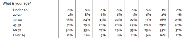
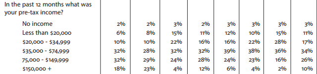
Yes, it’s the whitest, the oldest and the second-richest – but not by a lot
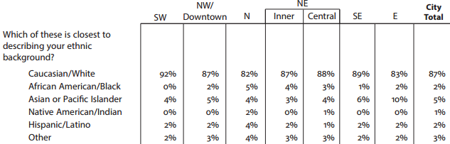
Portland is a segregated city in the sense that it’s disproportionately white throughout (a snowballed result of, among other things, Oregon’s horrific decision in 1844 to outlaw dark skin). But (maybe for related reasons) it’s actually fairly well integrated internally by race and income. No quadrant falls outside the margin of error for race, though Southwest’s estimate of 0 percent black population does make it unique.
(Note: the Portland Community Survey dramatically undercounts young people: 21 percent of Portlanders are in their 20s, according to the U.S. Census Bureau, but they’re just 6 percent of those surveyed. Same with people of color: the survey says 2 percent of Portlanders are Latino, while the Census Bureau says 10 percent. However, there’s no reason to think that this undersampling varies by quadrant, so Southwest is likely to actually be the whitest and oldest.)
On income, Southwest trails Northwest and Downtown very slightly in its share of people earning $75,000 a year or more. But it’s flat wrong to assume that a Southwest resident is well-off: 8 percent make less than $20,000, 18 percent less than $35,000.
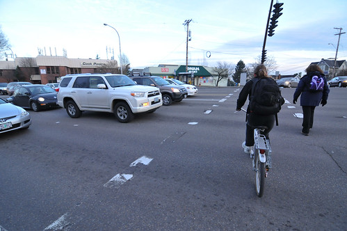
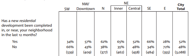
It’s the least safe part of Portland to bike and walk
That’s what residents say, anyway. This question is about “streets in your neighborhood”:
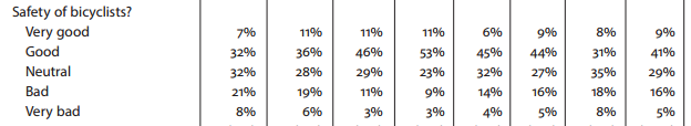
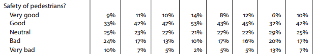
To look at incident reports, Southwest actually has very few fatalities of people biking and walking. But that’s largely because people are far less likely to do either, because they feel so unsafe doing so. Even East Portland, which for all its problems has more sidewalks than Southwest, falls a bit behind the 34 percent of Southwest residents who call walking safety “bad” or “very bad” and the 29 percent who say the same about biking.
It has almost as little biking and walking as East Portland
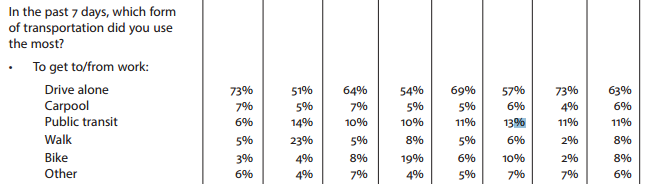

An inner Northeast Portland resident (defined here as west of Cesar Chavez Boulevard) is 13 times likelier to ride a bike for a trip than the average American.
Southwest and East Portlanders, meanwhile, are average Americans.
Advertisement
That’s a colossal cultural divide in transportation. Another detail to note with Southwest: there’s an unusually large gap between the percentage of work trips by bike (3 percent) and the percentage of all trips by bike (1 percent). In Southwest, biking is rarely something to be done casually.
It’s getting almost as little development as East Portland
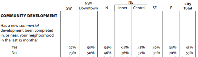
In part, this is probably because connected street grids with good walking, biking and transit have become popular places to live. But in part it’s a conscious choice. Here’s a passage from Oregonian reporter Brad Schmidt’s excellent 2013 series about East Portland:
The housing explosion never struck Southwest Portland. Residents refused to let it happen.
In September 1996, just eight months after the City Council approved the Outer Southeast plan, officials breezed into the West Hills looking to equitably spread their vision of housing growth to all corners of the city.
They presented a proposal with new zoning that would ensure “likely development” of 7,500 new housing units over 20 years. It included high-density apartments and mixed-use buildings along Barbur Boulevard, the area’s main commercial drag.
Residents were furious.
Judges, attorneys and doctors flooded City Hall with angry letters. Liz Kaufman, a political consultant who lived in South Burlingame, called the Southwest Community Plan “fundamentally dangerous.”
The proposed new zoning “dramatically and perhaps devastatingly alters the character” of neighborhoods, warned Kaufman, who went on to advise [then-Commissioner Charlie] Hales during his successful 2012 mayoral campaign.
The pushback was too much. Within a month, Hales, who at the time lived in Southwest’s Hayhurst neighborhood, announced changes “to ensure that we don’t sacrifice the very thing community plans are designed to protect – neighborhood livability.”
The Planning Commission suspended work in August 1998 after two years of limited progress. When the City Council finally approved the Southwest plan in 2000, all references to adding 6,500 to 7,500 housing units had been eliminated. Zoning changes that followed were minimal.
Even so, the stripped-down plan continued to evoke anger.
Amanda Fritz, then a planning commissioner who today serves on the City Council, fired off an indignant email to the manager of the Southwest plan in 2001. Fritz, a resident of West Portland Park neighborhood, was upset about an area that planners wanted to zone for townhomes. She thought larger lots would better serve families with children.
“I’ve decided I can’t continue to participate in a process where those who complain bitterly are more successful than those who attempt to participate constructively,” she wrote.
While city leaders eliminated growth targets for Southwest Portland, new zoning in east Portland ushered a massive influx of homes and people.
Residents rate it both affordable and livable
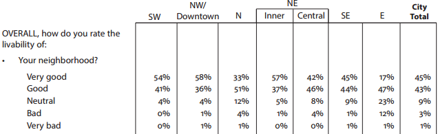

Here’s the final fact about Southwest: people like it.
A whopping 0 percent of Southwest residents rated the “livability” of their neighborhood as “bad” or “very bad,” the city’s lowest rate. Ninety-five percent call it “good” or “very good,” the city’s highest rate by an inch.
On the city’s east side, the more people are satisfied with their area, the less likely they are to say they can afford their homes. Not so in Southwest. The only more “affordable” areas to live are East and North Portland — which are presumably cheaper in part because they’re the lowest-performing quadrants for livability.
Both these ratings, of course, probably reflect Southwest’s greater wealth; generally speaking, people who make more money report more happiness with every aspect of their lives. But another reason is probably that in Portland, Southwest is weird: it’s a place that, unlike most of the city, looks and feels like much of the rest of the United States. Portland zigs; Southwest Portland zags. That’s how it’s built a brand and a niche.
And if Portland’s last two decades are proof of anything, it’s that weird works. Southwest Portland is Portland’s Portland.
We’ll be here in Southwest all week! And join us Friday afternoon for a BikePortland Get Together and social hour at the Lucky Labrador Public House in Multnomah Village (7675 SW Capitol Hwy) from 4:00 – 6:30pm.
 in crash statements")


")
Thanks for reading.
BikePortland has served this community with independent community journalism since 2005. We rely on subscriptions from readers like you to survive. Your financial support is vital in keeping this valuable resource alive and well.
Please subscribe today to strengthen and expand our work.
Follow the money.
No one in city council has ever been required to live and represent a certain quadrant of Portland. Not like other cities in this country.
However, Washington County has still spent over $27,000,000 and thousands of hours and sweat since 2004 to overhaul SW Oleson Road, add bike lanes, sidewalks, street lights, stormwater management, and clean up wetlands and adjacent parks even though Portland actually owns the Lamb’s Thriftway shopping center area at SW Garden Home Road and Oleson Road. Few roads in SW are like Oleson.
So what I’m hearing is that the vocal and influential in Southwest Portland didn’t want to be dense, multi-family, transit-bike-ped oriented. They got what they wished for, and today they still like what they got. Is that about it?
So perhaps the rest of Portland should stop trying to push SW to look like SE or NE? People who want to bike and walk and live in dense urban convenience can move to to NE SW or parts of NW. People who want to drive everywhere and live in ranch houses with two car garages can move to SW.
Speaking demographically, the “average” SW resident chooses to live in SW, as he or she has the financial means to live in a different area of Portland. This isn’t East Portland, where we (my opinion here) have an obligation to improve facilities and transportation because you can’t expect the average Lents resident to simply buy a house in Irvington if they want to live near transit and bike lanes.
I’m sure I just offended half of Lents and half of Irvington with my economic stereotyping. Beg pardon.
Many vocal people in SW want sidewalks, bike lanes, and crosswalks. Even people in unincorporated Multnomah county near Patton Road want bus service now. Just check the main points of the Bridlemile neighborhood association on the SWNI website. The public meetings reiterate this and that neighborhood is working on a new pedestrian bridge over a small creek in the NW part of their neighborhood.
So perhaps the rest of Portland should stop trying to push SW to look like SE or NE? …People who want to drive everywhere and live in ranch houses with two car garages can move to SW.
It seems to me that it is SW Portland that is the one constantly fighting to get safe and accessible infrastructure into SW, not the rest of Portland. Countless hours have been spent on projects like the SW Corridor Plan, The Comprehensive Plan, including the Transportation System Plan. Smaller projects like Tryon-Stephens Headwaters Neighborhood Street Plan and all of the advocacy around Barbur. The Capitol Highway Plan, two decades old, is nearly a fixture on the Multnomah NA and SWNI agenda. SW Trails is a model organization for Portland in providing connectivity for walking.
It is absolutely wrong to assume that SW residents only want to drive to destinations.
I find it interesting to note that there is quite a large Somali population in SW Portland, in the neighborhood of West Portland Park. I really enjoy living nearby and experiencing the cultural diversity along Capitol highway between Barbur and PCC Sylvania.
Although biking on Capitol highway there is fine (there are bike lanes, it’s relatively flat) it could be made much better with buffered or separated bike lanes and slower speed limits. Overall though, it’s a great neighborhood: access to a library, elementary/middle school, grocery store, Walgreen’s, restaurants, and coffee shops all within easy walking or biking distance.
An interesting anecdote I heard a while ago is that the western portion of US cities that grew up in the Industrial Age is typically the wealthiest (and whitest, usually not coincidentally). This was attributed to the mills that were located on the rivers/waters that many US cities were built on; mills which at that time spewed out a fair deal of pollution. Since the prevailing winds in North America are from the northwest, the pollution would be driven typically into the eastern portions of the cities, and the mill owners tended to build upwind of the pollution thus driving property values up (while mill workers tended to afford and settle in the eastern neighborhoods).
Not sure of historical accuracy, but I found it an interesting theory given the US cities I’ve been exposed to.
BTW, I had no idea how white Portland really is! (Where I live now Asians are the majority, then whites @36%, Hispanics @20%, blacks @3%).
On the whiteness: Portland isn’t actually quite as white as the survey says. It’s 78 percent, not 87 percent. The city survey undercounts people of color. It adds:
“We weighted our 2013 Community Survey data to match 2010 Census
race and ethnicity figures for Portland in order to assess the impact of
race and ethnicity on survey results. We did not see any differences
between our 2013 survey data, where minorities were underrepresented,
and in the weighted results, where the race and ethnicity
representation matched Census figures.”
I just added a note about the survey’s poor sampling of young folks and folks of color to the post. Thanks for calling attention to that.
I like living in SW because it often feels like living in the woods while still being close to downtown. We have lots of natural areas, partially due to the terrain (steep slopes, ditches, creeks) partially due to natural areas like Marquam Hill or Tryon Creek State Park. We have lots of trees and bigger lots, so we have lots of wildlife, birds, coyotes etc. Yet at the same time I live just 4.5 miles (the long way via Terwilliger) from downtown and can bike there. And thanks to SW Trails we have on of the most extensive urban trails network in the US.
Where I live in Hillsdale I’m lucky enough to be in walking and biking distance from a lot of shops, restaurants, library etc.But it’s not for the faint if heart because of the difficult terrain (steep hills, gravel roads or busy roads with no sidewalks or bikelanes), so casual bike trips are indeed not easy.
Michael do you know why NE gets split up into two categories, yet SE does not?
Nope. The first survey was in 1990, so I wonder if the split was intended as a way to get better data on the historically black neighborhoods west of like 11th?
Follow-up: Looking back at the 1991 survey, the area then labeled “NE” returned a 14 percent black response, while no other area (including the one labeled “Central NE”) had more than 3 percent. So I think that’s it.
There is also a hidden aspect to diversity here in SW that doesn’t show up in the statistics: we have a large Jewish Community in the Hillsdale area around the big Synagogue on Dosch as well as the Portland Jewish Academy, Middleman Jewish Community Center and various small orthodox congregations at the intersection of Vermont and Capitol. And a lot of these people walk on Saturdays. And more often than not they have to walk on narrow, but busy streets with no more than the fog line for bicyclists and a goat trail for pedestrians. The recent sidewalk/ bikelane project on Vermont alleviated some of that, but so many streets remain.
Many years ago I lived on SW Capitol Highway between Barbur and PCC. I got shot twice, by kids across the street with a high-velocity air rifle.
And right next door late one night the biggest drive-by in the history of Portland went down: two M16s on full automatic lacerated the neighboring apartment complex. Must have been a protective custody shake-out for drug informants. KATU did a quick story, then everything went quiet, probably for the best.
But a day later I counted the bullet holes in the siding–42 little ones. Folk had been moved out, thank God.
Surely it violated our noise standards as well. Did not exactly conduce to a peaceful sleep in that part of SW.
The e-bike is the only solution that will make SW bike friendly for commuters and not just for weekenders.
But most residents here can actually afford a $500 premium on their bike, so once we get the drivers to follow the law we’ll be all set. Even without an e-bike, it’s not terrible (except that you have to spend so much time puffing up a hill while drivers speed past.) I think a surge of e-bikes would make a world of difference to the neighborhoods (Want to be eco-friendly? Forget the tesla: buy yourself and 49 neighbors an e-bike.)
Personally since all the local talk lately has been about street fees(though it’s died – for now) . I’d love to know how much it costs to maintain a street in the hills over the rest of the city.
That coupled with how often maintenance is required since there are numerous factors which I assume would make the schedule for routine maintenance is needed more often than the rest of the city.
After all there are way more issues in infrastructure in the hills than their are for most the east side/Portland lowlands. Considering those roads often need more infill below them, culverts, shored up hill sides with retaining systems, small bridges, etc.
It’s definitely more expensive to build (or pave the many gravel) streets or sidewalks and bikelanes on the westside than the eastside for two main reasons: terrain and soil. The steep hills mean more run off. And we have impermeable clay soil where the east side has highly permeable sandy soil. That means that stormwater management makes sidewalk building and street extensions for bikelanes much more expensive per mile than on the east side. Also, because most areas of SW were incorporates much later than the eastside (50ies and 60ies), there is no systematic network of stormwater drainages. They are all over the place, often not connected or ending in someones backyard. That’s why a full rehab of Capitol Hwy to add sidewalks and bikelanes would cost 20 Million per mile.
But most of the time the city doesn’t maintain the streets at all. 2/3 of SW streets don’t have sidewalks (probably more like 90% outside downtown). That means 2/3 of streets are not up to city standards and thus not maintained by the city. E.g. we regular pay into a neighborhood pot to pay for the grading of the gravel street that leads to our (paved) street. We have lots of gravel streets and lots of badly patched up neighborhood streets that often don’t even have gutters.