(All images except the last are © Fat Pencil Studio – click through to reach a larger version)
Money isn’t everything, and neither is land value.
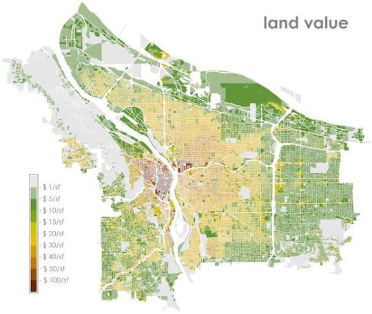
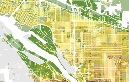
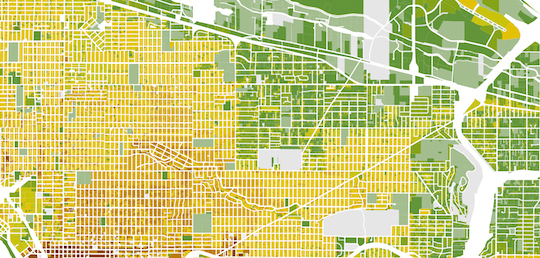
But if you want to know how the world works, they’re both worth understanding. That’s why the above map, created as a policy exercise by our friend Joshua Cohen of the civic graphics firm Fat Pencil Studio, is so much fun.
It’s a color-coded map of the market value per acre of the land — not the buildings, just the land — beneath every tax lot in the City of Portland.
Cohen created the map last year as a way of calling attention to a problem he sees in city government: the fact that the public sets aside so much real estate in high-priced neighborhoods for the free storage of private cars.
“What we are giving up by continuing to stick with free parking for most of our city?” Cohen asked on his company’s blog. “As a city grows and evolves, the demands on the public right of way increase. We need to use it more effectively.”
But you don’t have to be a fervent parking reformer to find interesting details in Cohen’s map, the first I’ve seen of its kind for our city and one that would probably give land-value wonks like Chuck Marohn and Joe Minicozzi a lot to nod sagely over.
You should check out the full-size image on Fat Pencil Studio’s website, but here are five details I noticed.
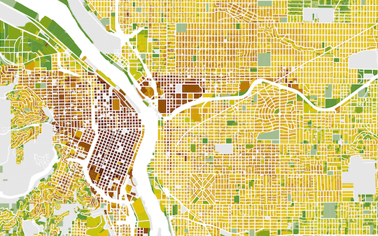
1) The Northwest District is the most consistently valuable part of town where parking is still free.
Why are the Northwest 20s the worst place in Portland to find a parking space? Because land along those fun, beautiful streets is in extremely high demand but (unlike in downtown or the Lloyd District) if you happen to own a car, you can store it in the street for free for as long as you want.
This automotive socialism is finally going to change, at least a little, when parking permits start being required in the area this March. But at $60 a year, those permits won’t cover anywhere close to the actual value of renting a 130-square-foot tract of land that could theoretically sell for $8,000 on the open market — which is a pretty good sign that Northwest parking annoyances will be with us for a long time.
Advertisement
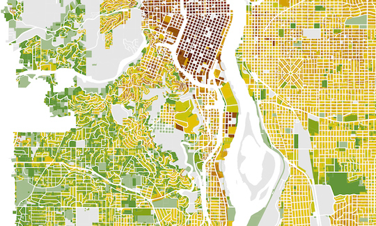
2) Southwest Portland isn’t worth much.
Three of Portland’s five city council members, and much of its ruling class, lives in Southwest Portland, our quadrant of winding roads and auto-oriented Anytown USA development (as well as plenty of neglected lower-income pockets). The wealth of many residents probably makes some people here think they’re sitting on the most economically important land in the city.
Nope. The mantlepieces might be fancy, but the dirt beneath them is a tax sink. Most of Southwest, and even a lot of the tony West Hills, is worth less than Mall 205 or the strip malls along North Lombard. And the value of Southwest’s land pales in comparison to spots like Old Town or the Lloyd Center — where you might meet someone who makes some rich folks uncomfortable but you’ll also see thousands of people conducting the business of city life every day.
3) Industrial areas aren’t exactly tax gushers.
Heavy industry can bring lots of good things to a city: exports, middle-class jobs, international transportation. But if you ever wanted an explanation for why cities are constantly rezoning industrial sanctuaries for other development, here’s why. Commercial and residential developers pay way, way more for land, because they can get more money out of it.
Side note: two of Portland’s biggest and most physically attractive factories produce a niche product — graduates. The University of Portland and Reed College have lovely grassy expanses that help convince smart people to pay lots of money to attend. But as long as their land is set aside for games of frisbee, it apparently isn’t worth much more per acre than a parking lot.
4) Cully and Brentwood-Darlington are low-cost enclaves.
There are only two big exceptions to the general rule that Portland’s most economically valuable land is the street grid between the West Hills and 82nd Avenue. The far southeast and northeast of that area have longer blocks, fewer sidewalks and far lower values per acre. In many ways, these are East Portland neighborhoods that just happen to be west of 82nd Avenue.
Why? The answer is in the final item…
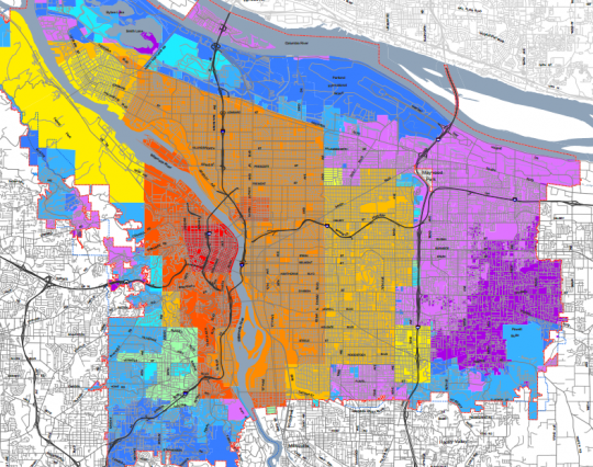
5) Portland’s entire land value map is basically just another version of this other map.
What’s the second map? It’s a city record of which decade each part of Portland was annexed by the city — and therefore, generally speaking, how recently it was developed. The most valuable and economically important parts of town all fall in the red, orange and yellow areas, all of which joined the city of Portland before 1930.
In other words, the most valuable and economically important areas of town are also the ones that weren’t built to prioritize the rapid movement and free storage of private cars.
— The Real Estate Beat is a regular column. You can sign up to get an email of Real Estate Beat posts (and nothing else) here, or read past installments here. This sponsorship has opened up and we’re looking for our next partner. If interested, please call Jonathan at (503) 706-8804.
Update 1/23: Several readers felt that I went too far with the comments about Southwest Portland, and after thinking about it, I decided they’re right. I feel bad and I apologize. You can read more in the comments section.




Thanks for reading.
BikePortland has served this community with independent community journalism since 2005. We rely on subscriptions from readers like you to survive. Your financial support is vital in keeping this valuable resource alive and well.
Please subscribe today to strengthen and expand our work.
“In many ways, these are East Portland neighborhoods that just happen to be west of 82nd Avenue.”
Interesting that you would say this. In fact these two neighborhoods are “historically” East Portland neighborhoods, meaning they were annexed at the same time (1980’s), and face a lot of the same infrastructure issues that the rest of East Portland does. So they are kind of in a rough spot because they don’t get a lot of the “benefits” of being in East Portland, but have a lot of the same problems. We’re currently working to try to get the city to more often recognize this.
Good Primer on B-D:
https://www.portlandoregon.gov/bps/article/88596
The sad part is that while this B-D document is over 25 years old, pretty much NONE of the recommendations have been done.
These two areas are still some of the best deals in real estate in the city though. And if you want diversity (like so many claim to in Portland) there is plenty of it.
“Most of Southwest, and even a lot of the tony West Hills, is worth less than Mall 205 or the strip malls along North Lombard.”
While this is true, you didn’t point out that many of the large lots in SW are not further developable due to their extreme topography (which is the reason OHSU was built up there, when a railroad originally bought the land sight unseen, then realized they’d made a pretty huge mistake and donated it to start the school). This is an area where using the land for parking wouldn’t even be an option.
I’d also be careful of calling certain areas “productive” over others. Many would argue that while industrial areas might not be worth as much (which will happen when you simply divide value/land size), they are plenty “productive”.
I agree, “productivity” is more complex than folks like Marohn (who more or less equates it with land value) imply. I rephrased a couple points in the post where it wasn’t the right word.
I see your point on an alternate meaning of “productive”, but in context of this post, I’ll defend the choice. Productivity in this sense is how much economic activity is generated *per square foot* of land. It’s an important concept when thinking about public investments. We should be prioritizing public spending on things like good streets and bike lanes, and discouraging giveaways like free parking, in places that already are productive or have the potential to become so. Conversely, paying to build and then maintain expensive infrastructure that serves just one or two large lots in a hilly area of, say, Dunthorpe, does not make economic sense.
Except most of the “free parking” we’re talking bout here is in the public right of way and would only otherwise be used for transportation right? Do we need to add bike lanes to low-trafficked side streets?
And much of the land we’re looking at here is used for housing. This gets into a very grey area of defining how “economically productive” housing is. Who is it productive (or generating income) for? Landlords? Homeowners? And how do you put a value on someone living in a place (besides the basic price value of the lot). If we’re going to go down that road than likely almost all of Portland would be more valuable and “productive” if it was commercial space, but clearly we still need places for people to live.
I’d argue that we should probably put bike infrastructure in place before traffic increases to the point of where car conflicts start to make it so that people will no longer bike on those streets.
Sure, but should we do that on ALL side streets?
Note that the yellow areas at about $25 a square foot cover much of the inner SE, N and NE area. In these areas, a standard 5000 square foot residential lot (50 x 100 feet) is worth $125,000! That may be almost as much as a small house.
In the orange areas, such as inner NW portland and a few places in close in NE and SE, the land value is $50 a square foot, or $250,000 for a standard 5000 sqft lot! In many of these areas, even a mid-sized 1500 square foot house is going to be worth less than the land it sits on.
Yep, and a good reason to build duplexes, triplexes, four-plexes and rowhouses – preserves affordability by being more efficient with the land (higher housing : land ratio).
“In these areas, a standard 5000 square foot residential lot (50 x 100 feet) is worth $125,000! That may be almost as much as a small house.”
Good luck with that. The only two places west of 82nd you will find houses for under $200,000 is the above mentioned B-D and Cully. You might find some incredibly dilapidated homes for under that, but few and far between. The areas you mention there is no way.
For example 4 blocks from me in Mt.Scott Arleta a developer just split a lot from an older home. They want $95k for a 25 x 90 lot. And that’s way outside your described area.
http://www.zillow.com/homedetails/Woodstock-Blvd-Portland-OR-97035/2103860655_zpid/
Davemess, the prices of those houses included the land. Large builders can consistently construct basic houses for 100 a square foot or less, so a 1500 square foot building should not cost much more than $150,000 in areas where land prices and regulation are low.
For example, Goodyear AZ: 1500 square feet, built in 2006, for $150,000: http://www.zillow.com/homedetails/2890-S-161st-Ave-Goodyear-AZ-85338/71624060_zpid/ (Last sold for $85k!)
Prices are high here due to high land prices and constraints on supply (zoning, etc)
I guess I don’t understand what your point is then. I am saying it’s hard to find even an empty lot in the areas you describe for $150k, let alone a lot with a house on it.
Yes the land is valuable.
I find it amusing that this map includes the “paper streets” that don’t actually exist like along US 30 near Linnton and atop Marquam Hill.
I believe the city actually owns the land under those “streets”.
As a whole, the 52 acre site of Alpenrose dairy with the future Red Electric Trail running on the north side of the property is worth a lot. Land for parks, trails, nature, active transportation, athletic sports, housing, and jobs. It is still there.
I would argue that the dairy (as currently sits) actually does some of the things you describe. There is a velodrome there, multiple ball fields, cyclocross courses, a go cart racing track, and a few other interesting things. Alpenrose is a pretty great community partner for a bunch of rec. groups in Portland.
Yes, they do and have those very things at Alpenrose. They also have let staff from Vermont Marquis Care park at Alpenrose. Alpenrose has also helped with safety vigils on speedy SW Shattuck Road.
Which is why I only buy Alpenrose milk. Gotta support long-standing local Portland businesses like Alpenrose!
Interesting Trader Joes gets a lot (maybe all) of their milk from Alpenrose. Check for the rose on the jug next time.
I argue that there is no place to find a free parking spot than the Lloyd District, the mall has the largest free parking lot in the city (maybe the state?)! The Temple Baptist Church also owns a bunch of vacant land in the Lloyd which they don’t pay taxes on and use on their big easter and christmas masses.
Do churches not pay property tax? That seems a little bit crazy to me! (N.B. I am a member of a church).
guess so.
http://www.oregon.gov/dor/PTD/docs/property-tax-exemptions_310-664.pdf
I don’t see how your snarky comments about the residents of SW adds anything valuable to the conversation. We’re not royalty overseeing the goings on of the city from our mansions, while being frightened by the working class of the Lloyd District, who, of course, are the people doing the city’s good work.
I grew up in SW, and I think that analogy holds true for quite a few of the people that live there, primarily those with large view lots.
There are something like 70,000 people that live in SW. So, by quite a few, do you mean this stereotype applies to 10? 100? 1000? Perhaps 1% of the population? In that case, I can totally understand why you’d stereotype the entire region.
Agreed. The “working class hero” crap gets a little old.
Can you explain that? I really tried to figure out what you meant but I don’t get it? Are you saying there’s too much value placed on being relatively poor?
I would argue the vast majority living in the orange-red areas (or yellow to red in the top map) aren’t “working class” anyway.
Thanks, Jeff. I hear you on the pointlessness of snark, and I’m sorry if this came off as an indictment of every resident of the quadrant rather than a few.
Andersen why even introduce the snark into the article then?
Because it can be very difficult to notice and filter out one’s internal biases.
Hey folks, if anybody is still reading this – this isn’t prompted by anyone else speaking with me about it, but I’ve been thinking about this exchange and Jeff, Lester, Mosby – you’re right. The broad-brush caricature of Southwest in this post was over the top and out of line. I feel bad about it and I apologize.
This was prompted in part by sitting in a meeting last night with a bunch of hardworking, ordinary Southwest residents – probably richer on average than folks in other neighborhoods, but whatever – trying to improve their neighborhood.
Exposure is a good cure for stereotyping. I need to get off my high horse and get to Southwest more.
I refuse to go to SW until there’s a safe way for me to bike there (or even walk for that matter).
There are already safe routes to SW, depending on where you want to go and where you’re coming from. They just aren’t very good for commuting. That’s the point of the Barbur discussions.
From downtown, Terwilliger is a beautiful ride. Or, climb up Vista and take a lap around Fairmount before dropping down one of several nice neighborhood streets.
From SE, the Riverview Cemetery is very safe. In fact, I rarely see any cars. Although the Sellwood Bridge complicates matters, at the moment.
There are plenty of safe neighborhood streets to take out of Lake Oswego.
If you’re coming from Beaverton, you’ll have to be creative, but there are routes.
And btw – check out SW Trails if you’re interested in walking SW. The work they have done is being used as a model for the rest of the city.
Hey, thanks Michael. I was pleasantly surprised to see you at the SWNI meeting and hoped to introduce myself, but that obviously wasn’t possible.
I hope you do get out to SW more often. Feel free to contact me if you ever need assistance in the area.
I see how you read it that way. However, I think Michael was saying that Old Town and the Lloyd have valuable land because they have intensive use by lots of people (most of whom – whatever their income – don’t live in either area), while Southwest has not-so-valuable land because the land is used not as intensively – mostly for suburban-style non-walkable single-family home neighborhoods, fancy though many of them are. I don’t think he was intending to skewer the people who live in Southwest or raise up the people who work/live/shop/recreate/whatever in Old Town or the Lloyd. Pretty sure he was intending to skewer the land-use of the Southwest as not providing a lot of economic value despite the high average income in that quadrant, and raise up the land-use of Old Town and the Lloyd as providing a lot of economic value, despite not appearing super fancy.
Most of the map just holds to proximity to downtown though (when there aren’t major hills in-between). I don’t know if it is really intensive use (granted that intensive use is there because of the proximity to downtown).
I guess these figures just seem so obvious to me: (buildable) land closer to downtown is worth more.
Or closer to anything. There doesn’t have to be some sort of magic in downtown; as Cora would say if she were here, the same density snowball could get rolling in Gateway eventually.
The map is based on tax assessment data. The assessor estimates the market value of a property, then allocates that value between land and structures. As a result, the assessed value of the land is mostly determined by the total market value of the property. The map thus largely reflects the selling prices of houses and other buildings in the area.
It also reflects lot size. The minimum land required to build the house is valued higher, by assessors, than the “excess” land (big yards, etc). So a neighborhood of $600K houses on small lots will show as having higher assessed “land value” than a neighborhood of the same $600K houses on large lots.
You can’t really compare houses to commercial, e.g. SW neighborhoods to Old Town. Commercial properties produce revenue, houses usually do not, which affects market value. A tatty commercial property can be demolished and replaced by a nice one to produce more revenue, a tatty house can be replaced by a nice one and it still won’t generate revenue.
The map showing date of annexation may coincide roughly with the map showing land values, but that mostly reflects that the older parts of Portland are the commercial center, more valuable for the reasons just explained, and the close in neighborhoods, tending to be more valuable due to proximity to downtown.
I don’t follow, John – of course houses generate revenue. People pay lots and lots of money to live in them. The reason we “can’t” compare residential land to commercial land is that we’ve piled lots and lots of restrictions on what can be done on that land: so many square feet for a driveway, minimum setback for a front yard, maximum height, etc. Without all those restrictions limiting its potential, there’s no inherent reason residential land would be vastly cheaper than commercial land.
The residential land we haven’t piled restrictions on, such as the NW district or Pearl, looks plenty valuable here.
Property becomes more valuable if the owner can generate more revenue from it.
A typical single family house generates no revenue for the typical owner, because he occupies it; it is an expense, albeit a required one. He could rent it, but renting a newly purchased house is seldom profitable (it briefly was, during the housing crash when distressed sales were abundant, but those opportunities are drying up.)
If a developer demolishes a house, cut the lot in two, and build two new houses right up the the lot line, that increases the revenue generated (via sale in this case) of the property, and hence value. If you building five floors of rental apartments on the lot, that further increases revenue and value. If you stack twenty stories of highrise office space fetching $50/sqft, that further increases revenue and value.
So, yes, if you abandon restrictions on development and use, you can get property values to rise, as long as there is enough demand for small houses, apartments, and office space.
You could also convert curbside parking to revenue-generating uses – not-free street space or paid parallel parking.
You could also convert bike lanes to revenue-generating uses – an existing curbside parking lane plus the adjacent doorzone bike lane will allow diagonal parking, which if metered will generate considerably more revenue per linear foot than parallel parking.
If the goal is simply to generate revenue and raise property values, all sorts of things are possible.
The city’s assessed values are also drastically variant (and very discrepant from actual market value in some areas). Assessed values (by state law) can only increase by 3% a year, regardless of what the market is doing around the house.
(and Michael said in the article that the maps are based on market value). Michael, assessment had nothing to do with these maps, right?
You got it, Dave – except in as much as the actual market values are distorted by the screwy tax subsidy system.
I thought the map shows land values as assessed by the tax assessor’s office. If that isn’t so, where does the data come from?
The assessor’s office provides both the taxable value (which is subject to the tax cap from the 1990s on) and its estimate of real market values of both the land and the improvements respectively. According to Cohen, this is based on the real market value estimate for the land.
The sad thing is that the “taxable value” isn’t adhered to at all in Portland. People in certain areas of the city have seen property tax increases of over 15%/year the last few years, despite the “taxable value” supposedly being limited to only 3% increases. Portland’s property tax system is a complete mess right now.
Sorry for the tangent. This is just a big deal in the area where I live.
“But if you ever wanted an explanation for why cities are constantly rezoning industrial sanctuaries for other development, here’s why. Commercial and residential developers pay way, way more for land, because they can get more money out of it.”
That is absolutely true and why the claims of some industry lobbyists that environmental regulations are the threat to industrial land and jobs are so bogus. We hear a constant refrain about a lack of industrial land and the need to roll back environmental standards to facilitate industrial development from interests who often have or will benefit from converting more industrial land to commercial or residential.
But more on point to this article, it is also true that industrial land within or closer to a denser, walkable street network- like the Inner East Side- produce way more jobs (37 jobs per acre) than sprawling industrial districts like the Columbia Corridor (6 jobs per acre) where heavy industrial uses are probably becoming even less job intensive. The proposed propane facility at Terminal 6 that is in the news this week would generate an abysmal 0.6 jobs per acre.
Jim
Nice work, Joshua!
I love a good map, maybe more than the next person, but this is a little problematic:
–industrial and commercial land are not assessed or taxed the same as residential land. The implication is that “land value” here means the same thing in all locations…and it doesn’t.
–a per square foot value doesn’t take into account lot sizes. Density is lower in SW, and since land value is associated not with square feet but with parcels, the presumed leveling effect of reporting land value this way doesn’t work.
–the market isn’t the same everywhere, and market dynamics further cloud the meaning of the map.
In other words, the colors on the map don’t mean the same thing in every location. You need to know something about history, underlying zoning, and market dynamics to decipher this, and I’m not sure, in the end, it makes the points you want to make. But hey….thanks for the map! Food for thought, as usual.
Useful critiques.
Could the Cully and Brentwood Darlington examples be evidence that sidewalks raise property values??
Just as likely (or maybe more so) that proximity to downtown is the main overall driver of property values.
But you raise a fair question. The big issue is how do we fund sidewalks though. These are neighborhoods with lower incomes.
I dunno, St. Johns is further from downtown than Brentwood-Darlington (a little over 8 miles vs. a little less than 8 miles) and a good bit further from downtown than Cully (about 6.5 miles) yet land values in St. Johns are higher than both.