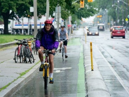
Toronto, Washington County Bicycle-Pedestrian
Coordinator Shelley Oylear said.
(Image courtesy Washington County)
The main drag outside Nike’s Washington County headquarters could soon be home to one of the region’s first curb-protected bike lanes.
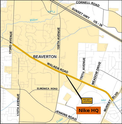
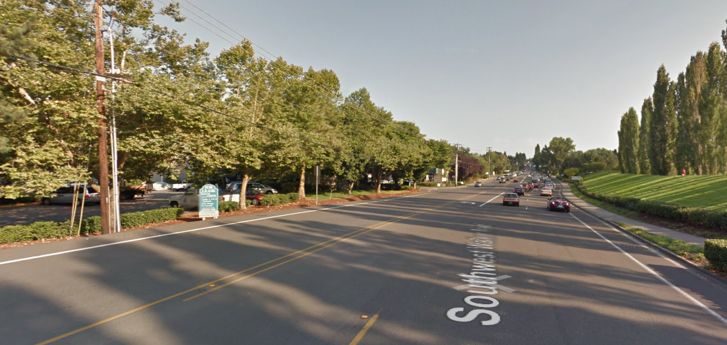
At an open house tomorrow, the county will present plans to widen 1.8 miles of Walker Road north and west of the fast-growing sportswear giant, making it a five-lane thoroughfare throughout the stretch and adding better sidewalks, storm drainage, street lighting and a low, rounded curb separating bike and auto traffic.
Washington County Bicycle and Pedestrian Coordinator Shelley Oylear said the project is part of a growing understanding in county government that it’s impossible to build wider and wider roads forever — as the county gets more dense, there simply won’t be space for almost all trips to involve a car.
“People are going to have to expect that if we build a four or five lane road, that’s it,” Oylear said in an interview last month.
That’s part of why the county is looking to build more protected bikeways that could increase the appeal of biking on busy streets.
The $15.7 million project will be paid for by county property taxes. Project manager Matt Costigan said perhaps 5 to 10 percent of that cost will go toward the bikeway.
As of last year, about 8,000 Nike employees worked in Oregon, 2,800 of them inside Beaverton city limits. The company won’t say how many work at the campus itself, which sits just outside city limits, but last year it purchased 18 buildings to expand its campus along Walker Road as far west as 158th Avenue.
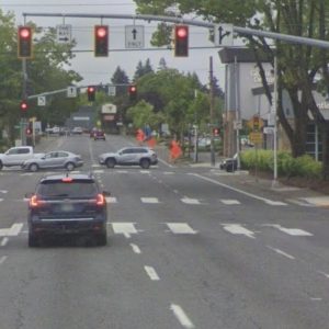
Here’s what Walker Road looks like today, looking southeast near Murray Boulevard (images from Google Street View):
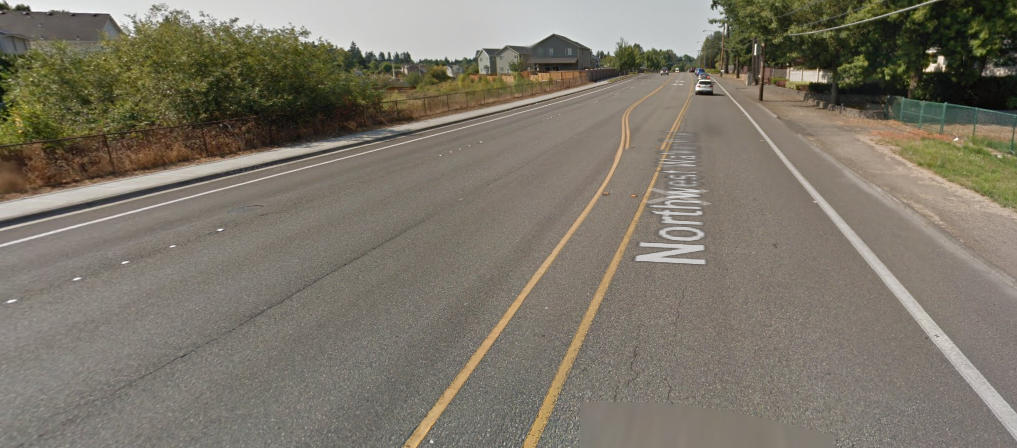
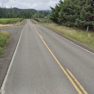
And here’s the street further northwest, near the other end of the project at 173rd:
The proposed Walker Road bike lanes wouldn’t be the county’s first. There’s also a much simpler facility on Farmington Road.
The open house for the event will be 5 to 7 p.m. tomorrow, Thursday, January 23, at Kaleo (Summit View) Covenant Church, 15900 SW Regatta Lane, Beaverton. There’s no formal program, so you can arrive any time during that window. Staff from Washington County and design consultant David Evans and Associates will be available to answer questions.



Thanks for reading.
BikePortland has served this community with independent community journalism since 2005. We rely on subscriptions from readers like you to survive. Your financial support is vital in keeping this valuable resource alive and well.
Please subscribe today to strengthen and expand our work.
And the good news is Nike won’t have to pay for the road improvements due to their 30 year tax agreement with the state on top of whatever agreements they have with Washington County.
Their deal with the state is that the state isn’t allowed to start levying corporate income taxes on their out-of-state sales. That’s never likely to be a major source of funding for local roads like this one.
I don’t mean to defend either the income tax deal or the funding of this project, just want to make sure the facts are straight.
It’s fair and worthwhile to consider what Nike’s contribution toward this road improvement is. Nike is widely considered to be a super desirable employer and industry to have in the area. Plenty of effort has gone towards persuading the company to stay here.
Go Shelley Go!
Cool. I’ve biked this quite a few times and cars definitely go very, very fast here. It’s also a nice throughway for bikes. Seems like a fitting spot to do such a project. However, I wish they would extend the nice treatment of Walker all the way to Canyon Rd.
This is my route to work, and wish they’d also extend this the other direction to Amberglen Parkway.
I ride Walker between Amberglen and 173rd daily and whole-heartedly agree.
In the evening, the car traffic on Walker slows everyone down, making it feel much like a safer bike route than Cornell (which hosts highway speed traffic anywhere west of Sunset High School).
I don’t know. I think the protected bike lane is the bone they’re throwing us so we won’t object to the increase in car lanes. Kind of like what they offered in the CRC plan.
I’m on a business trip in San Jose, CA right now, and they have pretty nice bike lanes here, but they’re on massive multi lane roads. Nobody uses them.
I say no.
…so you are saying “no” to any bike lanes on multilane suburban arterials, like in San Jose? or “no” to the proposed bike track on a multilane arterial near Nike?
I’m saying no to the continued expansion of arterials, even if bike infrastructure is added. I won’t get my way, of course, but I will register my opinion.
You must not have seen me today ;). Silicon Valley bike counts have been up almost 30% annually since I moved here in 2008 – although with the boom that’s going on I’d imagine solo car trips are up way more. I used to ride this very route (Walker Road), and the only thing I can say is I currently ride Homestead Road where the new Apple headquarters is going, and contrary to what WA County is doing Sunnyvale/Cupertino took out our nice wide marked bike lanes and I now have to pedal in-lane with impatient drivers (many of whom are, ironically, playing with their iPhones). We call it “running the gauntlet.”
By my experience between riding frequently in both Beaverton and the south bay area, there are far more year-round cyclists here – but then again it was 70+ degrees and sunny today and I was surprised to not see as many other bikers as usual. I can hold my own as a vehicular cyclist, but I’ll still take protected bike lanes over nothing, any day. I hear you on the ‘bone’ thing, though.
You might have seen some of my relevant comments in other threads – one of the problems we’re seeing here is many ‘vehicular’ cyclists prefer to ride on the expressways, but they’re narrowing those “massive” lanes we ride in to make room for more car lanes while adding walled-in MUPs that they assume all bicyclists will use.
Enjoy your trip!
-P
I have to cross Walker (usually from south to north) almost every day. Because the north-south routes across Walker are limited and have poor connectivity for bikes, that means that every day I have to turn right ONTO Walker, ride it for a little ways, and then attempt go left. And there is nowhere on Walker that left turns don’t suck for bikes.
Regardless whether there is a left turn lane (as at Meadow Drive, Murray or Cedar Hills Blvd, where the queues get long) or isn’t one (Park Way, Filmont, Westfield, where you have stop on the right side of the road waiting for traffic to clear) traffic is heavy and aggressive on Walker, making the move a game of roulette during commute hours.
So although a physical barrier separating me from cars is a “nice-to-have”, what I *REALLY* need on Walker is a way to either cross it (to a route with actual connectivity) or turn left off of it safely. Although it’s half mile to a mile further east of the project area, the ideal place to put such a facility would be at Park way, because a lot of the bike traffic in this area is trying to connect to Portland, and Park is the best route for that. From Murray on west, the connectivity towards Portland from north of Walker is poor.
I suppose a Copenhagen-left with a dedicated phase, like Portland has built at Weidler and Williams, would be too much to ask at Walker and Park. But Park is only a couple blocks away from Murray … how about protected left-turn lane in the center of Walker between Murray and Park, with a dedicated signal phase for bikes that allows them to get into it ahead of the rest of traffic?
So please, WashCo, as you go forward with this project, think not only of making it nicer to ride ON Walker, but also think of how we get OFF Walker safely, with respect to nearby routes that actually connect through.
One of the downsides of protected bike lanes, is that between intersections, they can more or less prevent people riding in them, from transitioning across main lanes of the road to make left turns.
Protected bike lanes, hopefully, are conceived to conceived instead, to create a more comfortable, safer riding environment for people that aren’t interested anyway, in mixing it up with motor vehicle traffic. That does still leave the challenge of creating efficient ways for people riding, to cross roads such as Walker, that are busy with motor vehicle traffic.
Taking as an example, Jenkins Rd westbound at Jay St (bordering the Nike Campus), one of the bike lane configurations that transitions riders from the far right side of the road to left of the right main travel lane, is used. Maybe that could be used as well, in other situations in this area.
Giving more space to aggressive under-policed motorists is not going to get the so-called “interested but concerned” in the saddle. Nor is building infrastructure that makes crossing intersections more difficult and dangerous.
Hear, frickin’ hear! I usually head downtown from farther north of Walker (i.e., Cornell/Barnes), but I have headed to town a time or two from farther south. A couple of times, coming from 185th/Baseline I have used the left turn lane from Jenkins to turn onto Murray, then turned right onto Walker and merged over to wait in that tiny yellow point where the WB left turn lane from Walker to Murray just starts to diverge so I can make the left onto Park. Another popular NB route I’ve tried is to use Ecole to cut through from Jenkins to Walker, then make a left onto Walker and a right onto Park. This latter maneuver is also a nightmare due to the usually fast and heavy traffic on Walker.
So putting a neat separated space along a straight section with relatively few intersections is great, but it isn’t much of a real improvement if connections at the ends are not improved–or perhaps made worse. At best, this is a mitigation of the conditions that would be induced by widening this stretch of road to five lanes.
It isn’t mentioned, but will the same treatment be applied to both sides of the street? Will the one side be intended for two-way bike travel (as it is on the Farmington “cycle track”)? How will a left turn from Walker to NB Murray be managed (my guess: forced two-stage, “pedestrian” turn)? What about a left turn onto Meadow? 158th? At least there are plans for a separate sidewalk, unlike the Farmington path. I’m also assuming there won’t be “BIKES YIELD” signs at every driveway and non-signalized intersection…
I admit I am paranoid, but “improvements” like this seem a little bit like quarantining the well to prevent them from getting sick, while letting the sick people run amok. Hey, you’re essentially under house arrest, but at least you won’t get sick!
5 auto lanes, really? Sound’s very last century. If they proposed 2 protected bike lanes, 3 auto lanes and a dedicated BRT lane, now that would be progressive!
Have you been to Beaverton before?
If there are going to be 5 lanes for motor vehicles, on a road where traffic goes very fast, the bike lanes better be VERY protected. I don’t mean with a curb. I mean with something like a Jersey Barrier.
Agreed. The barrier ought to prevent an out-of-control vehicle from entering the bike space. BP has profiled some of the artistic treatments of jersey barriers in NYC, so it can look good too.
hmm sounds like a road in SW Portland that we all know and love……
Ehh, you get used to it. That’s suburbia for you. Murray Blvd has 5 motor vehicle lanes, a ridiculously high 45mph speed limit, and mere “normal” bike lanes, and it’s fine. I ride it all the time, no big deal — other than trying to make left turns on it, which is awful but no worse than Walker.
True. One of the points I continue to hammer into planners at our BAC is that intersections are where the real hazards are, and the statistics haven’t traditionally shown that higher-speed traffic leaving the roadway is a significant danger to adjacent roadway space between the intersections. I say traditionally because I’m personally observing more ‘incursions’ in the era of smartphone prevalence (and a friend was lost last year to a distracted driver leaving the lane), but when it comes to dividing up funding the costs of ‘danger-proofing’ long stretches of roadways are pretty high. That, and I personally believe it reinforces the perception that bicycling among auto traffic is inherently dangerous.
Your previous comment is exceptional, by the way.
I have a feeling it is going to get worse (increased distracted driving) before it gets better (self-driving cars).
“…I don’t mean with a curb. I mean with something like a Jersey Barrier. …” dwainedibbly
When I first read this story earlier today and looked at the picture illustrating it, of a protected bike lane in Toronto, one of my first thoughts was, that the main lane side of the dividing barrier, should, rather than the nice cambered profile feathering down to the street…maybe be at least the 90 degree profile, 4″ or so high like a regular curb, to offer more of a deterrent to people driving to stay away from it.
On the bike lane side, the cambered edge isn’t too bad an idea.
crossing Walker – I’ve had reasonable success crossing at Ecole. Wait for a break in traffic, then zip north into the church. But I second improving the eastern end of Walker, from Cedar Hills eastward to Canyon. Commuting westbound in the morning, it is safest to take the lane from William Walker school westbound. Nothing like some jerk sitting on your rear wheel honking the whole time. Also, widening the narrow bridges west of SW 173rd, so there would be room for a shoulder or bike lane.
I ride that stretch multiple times a week. Don’t find it to be all that problematic. Now south of the campus on Jenkins at Jay, where the right lane of traffic transitions into the right turn lane crossing over the bike lane is a major safety issue. Which is why I take Walker.
I’ve described the Jenkins/Jay road exchange, here:
“…Taking as an example, Jenkins Rd westbound at Jay St (bordering the Nike Campus), one of the bike lane configurations that transitions riders from the far right side of the road to left of the right main travel lane, is used. Maybe that could be used as well, in other situations in this area.” http://bikeportland.org/2014/01/22/washington-county-proposes-protected-bike-lane-outside-nike-hq-100308#comment-4488199
It works. It’s advisable for riders to use very prominently displayed hand signals for some distance before where it angles away from the right side of the road bike lane. If anyone reading has some viable, alternative ideas for this type situation, I’d be interested in reading about them here.
At a minimum it could use a sign indicating cars must yield to bikes.
Insufficient advance notice to road users of the bike/main lane, lane exchange, is one of the weak points of that configuration.
With all the vehicles constantly running over them, the pavement paint wears away and becomes faint, as it is now. When freshly laid down and for awhile after, the lines were fairly bright, wide and visible. Maybe some kind of sign on a post in advance of the exchange could help though: something like a ‘RR crossing’, but ‘Bike Lane Crossing’ instead.
The problem with Walker is the stretch West of 173rd where there is not lane and no shoulder. Because of that, I always take Jenkins.
Yep. I ride from 158th too 185th on Walker and the problem is clearly West of 173rd where the bike lane is anywhere from 0″ to standard width. I wonder why the focus on the area around NIKE?
I bike Jenkins past Nike and I was told Nike will improve biking along Jenkins as well, from Murray to 158th. I was told they’ll be adding a buffer to the existing bike lane, which would be 100 times better than the bike lane that quickly becomes crap as soon as you get past SW Jay St.
I used to commute right by there. everything west of Park way is terrible for bike commuting. a rounded curb will not prevent distracted driving deaths. a 4″ or higher square edged curb should be utilized.
The bike lane that quickly becomes crap as soon as you get past SW Jay St. is a great, though narrow, example of an increasing problem that is bothering me in Washington County. It seems that more and more bike lanes are being constructed of concrete, frequently elevated from the street and containing the very frequent expansion joints that are typical of sidewalks. A problem is that even if you can tolerate the constant bump-bump-bump from the joints, the concrete deteriorates over the years but is never repaved. Jenkins has a bad example of that as you are climbing westbound to Costco, where the concrete has broken up and become uneven. Another is going north past the Rec Center on 158th where the entire standard width bike lane is concrete and has become terribly rough.
The area around the big Intel fabs west of Cornelius Pass Road is disturbing. It seems that all new bike paths around the plant are of the raised concrete sidewalk variety. I would much rather ride with the traffic than tolerate the constant bump-bump-bump from the joints, but you know what the drivers are like when there is a “nice bike path right THERE”. This design mentality really needs to change – at least pave them with asphalt which is more readily renewed as needed.
I’m cautiously watching the Bethany BLVD expansion near my house. The final plan calls for bike lanes in both directions from Bronson to West Union and beyond, but currently there are no bike lanes between Oak Hills and West Union, and it doesn’t look like there will be room for them either.
Commuting from Hillsboro to N. Portland I travel past the Nike Campus on my way home. Personally I find less of a problem with the bike lane, but a real problem crossing Walker from the bike lane to turn left onto Parkway. Take the money and spend it on infrastructure to create a safe and viable option for cyclist to safely cross here. The rest of the ride home is a piece of cake. Walker to Parkway is the crux of my commute. An early green for the bike lane and a quick re- stripe of the center lane would go a long way towards making this safer.
Will Nike also retrofit it’s large expanse of turf grass too? A great place to grow food locally.
I agree with most of the commenters, except for the jersey barrier – it’s dangerous and impractical for this application.
Buffered bike lanes are preferred over protected for two reasons: They require less overall space by not introducing a shy distance to both sides of a curb, and because of the complete lack of vehicle redirectional ability of rounded curbs at higher speeds (>25). It’s not “protected” at all, and I’m surprised they’re going with this design.
If you have another $10-20M laying around, adding buffered bike lanes and continuous sidewalks on the 2 mile segment of Walker between Ecole and Canyon would be a game changer.
Jonathan thank you for covering Surburbia for us, it means a lot.
It’s a nice start, fancying up that path of walker in front of the Nike Campus. But what I’d really like to see is the bike lane passed walker after Murray get better. Heck, I’d be great if it didn’t end around SW filmont, but extended to SE cedar hills. Even trying to put a bike lane on SW Cedar. If the goal is to get more people biking, doesn’t it make sense to improve the connectivity to Beaverton TC? Have options from a major hub? Just saying. My problem areas on walker usually start as I approach SW Cedar, not while I’m in front of the nike campus.
I was at the open house last night and there were no protected lanes on the segments of 158th and Walker Road. Someone might want to follow up with them and get a summary of where PBLs still are being proposed and where they have been removed from consideration.
What did you tell the engineers?