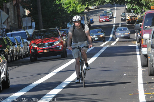
(Photos by J. Maus/BikePortland)
PBOT has completed a lane “reorganization” project on NW Everett Street between NW 25th and I-405. As we reported back in May, this project is the result of two factors: An understanding by the bureau that the intersection of NW Everett and 16th is unsafe due to its history of right-hook collisions; and a repaving project that gave them a golden opportunity to do something about it.
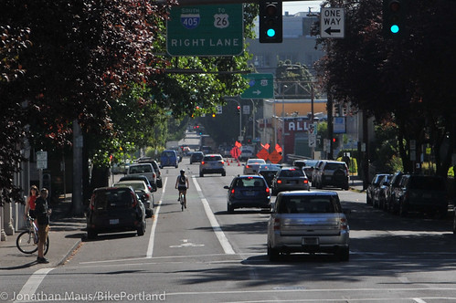
I spent about thirty minutes this morning taking a closer look at the new lane configuration. (As you read my observations and check out more photos, keep in mind that NW Everett is a one-way street that goes eastbound from the Nob Hill neighborhood all the way to the Willamette River. It has a gradual decline almost the entire way.)
The changes start at NW 24th, where PBOT has striped a mixing zone to encourage bicycle riders over to the left side of the street. Putting bikeways on the left is a new — yet increasingly used — tool by PBOT to help mitigate conflicts on the right side such as right-hook collisions and bus/bike conflicts. A street design update coming to N Williams later this summer will also feature a left-side bikeway.
Advertisement
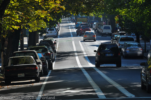
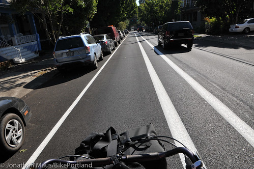
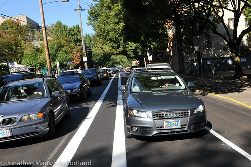
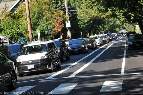
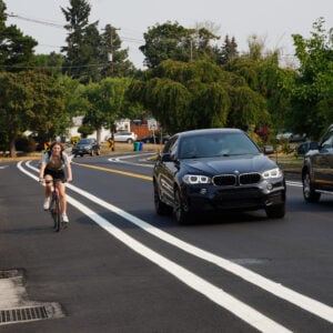
The new buffered bike lane on Everett starts at 23rd (new signs tell drivers in the left lane that they must turn left from Everett onto 23rd). Once on the new buffered bike lane, you notice the width right away. At seven-feet wide, the bike lane itself feels nice and wide. Then there’s a three-foot buffer. The 10 feet of width is needed, because, while PBOT removed one standard lane from the cross section, they have maintained auto parking lanes on both sides of the street. This means the new bikeway is in a door-zone — albeit a less dangerous one because it’s on the passenger side as opposed to the driver’s side.
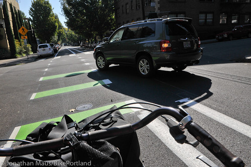
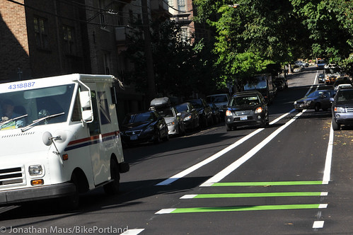
The buffered treatment continues for several blocks, but it goes away approaching major intersections. At NW 21st, the buffer drops and PBOT has created a “mixing zone,” an environment where riders need to be prepared to share the lane with people turning left.
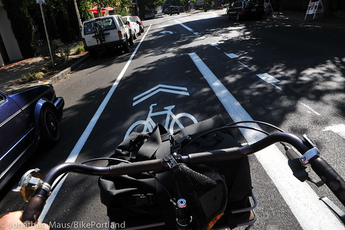
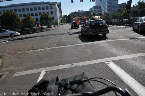
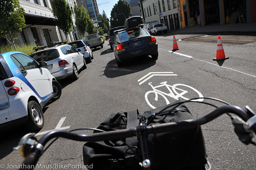
At NW 19th, the bike lane narrows, the buffer goes away, and the street widens to accept an additional standard lane. Then, as Everett approaches the I-405 crossing, it disappears completely. PBOT has installed a sharrow just east of NW 14th to help transition into the different environment of the Pearl District.
Now that we’ve taken a photo tour, here are a few of my observations:
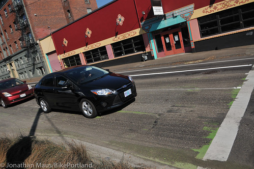
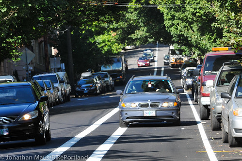
While the new bikeway is nice and wide, it feels under-designed. There is only scant use of green paint (a few skinny strips prior to intersections), there is no physical protection (like planters, curbs, or plastic wands) or striping of any kind in the buffer zone (like hash marks or yellow color like on NE Multnomah), there is only one bicycle symbol on each block face, and no overhead signs to remind people that the left lane is only for bicycling (something I’d love to start seeing here and elsewhere).
Fortunately, PBOT says they’re still assessing the new striping and some tweaks are still possible.
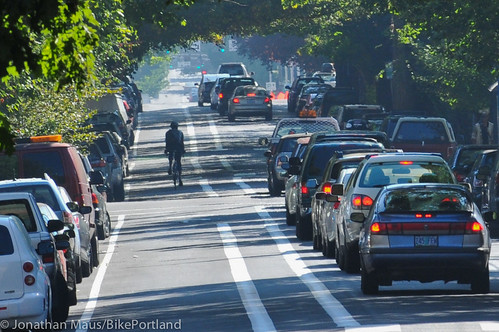
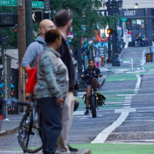
With a lack of visual and/or physical cues that the left lane is for bicycling only, people use it for driving. Whether they’re swerving into the bike-only lane to avoid congestion, or to access a parking space, or simply because they’re oblivious of the legal standing that bike lanes have in Oregon — all those behaviors undermine the safe conditions we’re trying to create.
When PBOT did a similar treatment on SW Stark and Oak back in 2012 they also left the bike-only lanes under-designed. It took an outcry from the community for them to go back and add the green paint. With that addition, Stark and Oak are arguably the best bikeway in the central city.
Speaking of couplets… This new and improved bikeway on Everett (a one-way street eastbound) only makes it more unfortunate that we don’t have an westbound couplet on NW Flanders or Glisan. We had a golden opportunity on Flanders when former Mayor Sam Adams (then the transportation commissioner) proposed using the old Sauvie Island Bridge as a biking and walking-only bridge over I-405; but that plan was scrapped after it fell victim to mayoral politics. Today, the lack of safe bike crossings of I-405 north of Burnside remains a major gap in our network.
(UPDATE: A commenter below says a source at PBOT has informed him that they are planning a similar buffered bike lane on NW Glisan (a westbound complement to Everett) when that street is repaved. Great news!)
“This is a big improvement in my everyday cycling and I couldn’t be happier about it.”
— Brendan Ault, nearby resident who rides Everett daily
With the new cross-section having one standard lane, a similar situation will develop here as currently exists on Stark and Oak: When service vehicles like FedEx and garbage trucks double-park, the cars behind them back up. When that happens, people become impatient and they will tend to swerve over into the bike-only lane to get around the stopped traffic.
As for what the reaction from users has been so far, I’ve read nothing but positive responses. Reader Brendan Ault lives near Everett and 22nd, works downtown and wrote us yesterday to share that he “couldn’t be happier” about the new bike lane. “In the past,” he wrote, “I haven’t gone farther east on Everett than 19th because even with the stub of a bike lane leading up to the 405, as soon as I got over the bridge I got pushed into traffic on Everett without any chance to get over to Flanders and calmer traffic/sharrows. Now that the buffered left hand lane is in place, it is easy to cruise down Everett, across the 405 bridge and take a left onto Flanders, take that to Broadway and join the bike commuter trains there.”
Seth Hosmer, who lives in the southwest hills and owns a business in the Pearl District, also likes them. “With the new pavement and the nice bike lane,” he wrote to us via email. “It’s definitely a big improvement.”
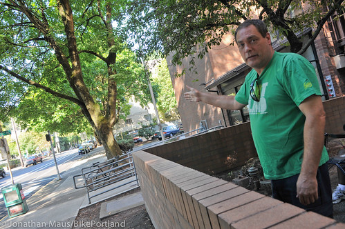
But of course not everyone is thrilled about the change. John Blair, who lives in an apartment at Everett and 20th, was outside while I was taking photos this morning. “This is crazy!” he exclaimed. “It’s completely unsafe.” Blair said drivers in cars are backing up for blocks during peak hours, while the bike-only lane sits empty. “The other day, a TriMet bus was stopped behind other cars. Then it swung into the bike lane and almost took a cyclist out. He [the bus operator] had nowhere else to go!”
Blair said he heard that PBOT traffic engineers said the new lane configuration (from two standard lanes down to one) would not lead to more auto congestion. “How could he think that?!” Blair said incredulously, “Is he smoking crack? He obviously doesn’t live down here.”
If PBOT wanted to keep buses and cars from using the bike-only lane, he says “They should have put up a barrier.”
——
What do you think about the new design? Share your comments below and make sure to tell PBOT your opinions via safe@portlandoregon.gov.


Thanks for reading.
BikePortland has served this community with independent community journalism since 2005. We rely on subscriptions from readers like you to survive. Your financial support is vital in keeping this valuable resource alive and well.
Please subscribe today to strengthen and expand our work.
It looks a lot like the left side bike lane on 2nd ave in downtown Seattle, which is currently being replaced by a two way bike track and separate signals due to the fact that it’s the most dangerous installed bike facility in the city.
I disagree that the 2nd Ave bike lane is the most dangerous bike facility in the city (Seattle). I’ll concede it’s awful, absolutely, and I would never use it, but it’s not the worst. SDOT has a staggering record of poorly implemented cycle facilities.
That said, I’m not a huge fan of two way cycle tracks – particularly on slopes.
What would you consider worse? (I’m not making argument, just curious where to avoid that I might not know of). The whole mishmash of attempted infrastructure west of fred meyer into ballard is pretty bad but isn’t fraught with cars constantly flying at you from every direction looking in the opposite direction they’re moving (2nd ave taxis, parallel parkers, valet parkers, parking lot/garage exiters, left turners from 2nd, right turners onto 2nd, lane wandering buses). In a world with no cars the missing link is a worse piece of infrastructure but in application I’ve never been in such consistent peril than on 2nd.
I’d like to know too, especially since it’s claimed another life today. 🙁
I’ve said it before: diagonal hash lines in the buffer help keep drivers in line.
i still see the occasional car use the holgate bike lane but i almost never see cars drive in the painted bike lanes on oak or stark.
Really? Because when I sit in my weekly meeting at work in a conference room overlooking 10th and Stark, I routinely see people driving down the green bike lane from where it starts at Burnside all the way past my field of vision between 10th and 9th. I’ve never seen any enforcement. Not ever.
Granted, it’s by no means a significant percentage of cars doing the above, but I see at least a few per hour doing it every day. That said, I definitely see a very significant percentage both straddling the bike lane the whole way and “sharing” the bike lane to make right turns where they should be turning across the lane after yielding (the actual mixing turns at streets like Broadway excepted).
Also, they recently repainted the green on Oak and Stark (good!) but they painted over the bicycle symbols and never replaced those (bad!).
Regarding Everett, I sure wish PBOT would put in hash marks in the buffer zone. It would help cognitively set apart that lane as something separated from motor vehicle traffic. Even if it’s only a few per block it would help. They must be intending on adding the bicycle symbols later – please say that’s the case.
From the pictures here, it looks like the buffer zone is the bike lane and the rest are auto lanes.
riding on a bike lane is not the same thing as staring at a bike lane during an apparently boring meeting.
I ride Stark for two blocks on my daily commute and see a car in it several times a week.
http://youtu.be/TYzsPZLxFdI
Here’s an 18-minute snippet compressed down to under two minutes. In it, you can see a significant percentage of drivers straddling on or over the white line – despite the car lane being more than adequately wide and free of obstacles. At 21 seconds, there’s a car that is more than halfway into the green lane despite there being a cyclist in the lane. There’s also more than one car that makes a right from entirely in the bike lane instead of across it after yielding to it.
Most cars that that turn left from 11th onto Stark also do it wide and into the bike lane. Many correct themselves but some only after they’ve traversed more than half the block.
holgate has hatch marks in the buffer lane and i routinely see cars encroaching. we need paint — green paint. enforcement would be nice too but…fat chance.
Reza is right, no treatment will stop everyone from encroaching. Green (or blue) paint is quite useful in merges and select areas but using it everywhere diminishes its effectiveness. They’ve treated some dangerous intersections down here (silly valley) with it and what they used is sketchy to ride on wet (though it hasn’t rained here in almost 2 years now).
http://www.newsbiscuit.com/2007/12/03/cyclists-furious-as-council-paint-everything-else-luminous-green/
Yeah you’ll still see people driving in those lanes occasionally.
I still see cars driving down the transit mall in the bus-only lanes. Sometimes even in the wrong direction!
“Speaking of couplets… This new and improved bikeway on Everett (a one-way street westbound) only makes it more unfortunate that we don’t have an eastbound couplet on NW Flanders. We had a golden opportunity on Flanders when former Mayor Sam Adams (then the transportation commissioner) proposed using the old Sauvie Island Bridge as a biking and walking-only bridge over I-405; but that plan was scrapped after it fell victim to mayoral politics. Today, the lack of safe bike crossings of I-405 north of Burnside remains a major gap in our network.”
You mean “Everett (a one-way street EASTbound) makes it more unfortunate that we don’t have a WESTbound couplet on NW GLISAN (not Flanders), right? Flanders is a two-way street while Everett and Glisan is the one-way couplet.
Thanks Reza. I made a mistake and have fixed the error. However, I left the Flanders part and just added a note about Glisan.
I STILL MISS FLANDERS.
Yet another missed opportunity for a protected bike lane, which would easily prevent the misuse of the lane by drivers AND make more people feel comfortable using it, avoiding the “empty lane problem”.
In other news, the list of cities with more miles of protected bike lanes than Portland now includes: Champaign IL, Austin, Seattle, Cambridge MA, Boulder CO, Washington DC, Indianapolis IN, San Francisco CA, Chicago IL, and New York City. Nipping at Portland’s heels are Temple City CA, Cincinnati, Long Beach CA, Eugene, Urbana IL, & Baltimore.
i don’t think there is much evidence that so-called protected bike lanes are an improvement over buffered bike lanes or in road cycle tracks. a true dutch-style cycle path would be an improvement but i can’t think of a single example in the usa.
Here’s a link I’ve tried to post several times before and usually gets caught in BP’s spam filter:
http://bikesiliconvalley.org/2014/06/protected-bike-lanes-increase-bike-traffic-75-new-study-finds/
your link does not address my comment. i think most agree that installation of new bike infrastructure is correlated with an increase in ridership on that particular route. nevertheless, there is very little data showing that a north american protected bike lane is more effective at promoting ridership than a cycle track or buffered bike lane. imo, the interest in protected bike lanes from transportation planners has more to do with preserving parking spaces than creating an optimal cycling facility.
Sorry, I was replying to Jacob’s comment with another article he may be interested in, and honestly to see if the link would come through. I won’t address your comment because we agree; in fact there’s no accounting for the general rise in popularity of cycling over that period anyway. Personally I’m comfortable riding alongside parked cars, and most of the danger I see is drivers drifting rightward into bike lanes due to the crown of the road and even slight inattention to driving (road crowning is IMO an understated factor in the effort of driving a car, which oddly are all still designed to drive straight on flat roads – which generally don’t exist).
IMHO the optimal solution includes reasonable bike lane width (3′-5′) and just a little buffer space (~1′), and the hashing treatment provides a notable visual identity to the buffer space as such. That being said, those are the optimal solutions for me, an experienced ‘utility cyclist’ (guess we have to specify now ;). I don’t like anything physical between me and a travel lane that I may have to take or even swerve slightly into, but physical separation from cars is comforting to many – even a deciding factor.
At least there’s never a missed opportunity for someone on BikePortland to say “that should have been a cycle track”.
The original solution was to use Flanders as a neighborhood greenway, and link its ends at I-405 with the old Sauvie Island Bridge. It’s superior in every way.
Andrew Sullivan at the City has informed me that a NW Glisan buffered bike lane west of I-405 to mirror Everett will be done whenever that street is repaved.
“whenever” is not exactly a promising target date.
That’s the bureau’s restriping M.O. these days – see Willamette Boulevard.
squee! thought i sure would like one east of 405, too. i can keep up on everett downtown, but not on glisan because it’s uphill. drivers get upset when i delay their entrance to the freeway.
Jonathan, having ridden the left side lane now do you think this treatment will improve riding conditions on N. Williams?
Agreed with Pete, hash lines would help clarify the buffer zone. And I agree that the 7-foot bike lane (slightly wider than most cars) looks too much like a general line and needs more visual distinction. I’ll have to check this out soon.
I do wonder how well a left-side bike lane is going to work. I know this is mostly to eliminate the downhill right-hooks at the freeway entrance, but maybe a block-long mixing zone on the right might have been a better solution. As Cheif mentioned Seattle is getting rid of an infamous left-side bike lane, as did Minneapolis on the now-luxurious-for-cyclists Park/Portland couplet.
It’s going to look like a separated (all) vehicle lane as long as it’s missing the bike symbols at every block. And yes, hash marks would be ideal in differentiating it too.
Lengthened mixing zones is how they generally do it in CA, and I’ve found they work better when they’re on the right (a few places around I-280/Palo Alto area make you merge left with cars and then force them to merge back to the right across the bike lane). One problem with it here is that heavy traffic becomes bumper-to-bumper and the cyclist has to know to take the lane beforehand (sometimes aggressively, sometimes waay beforehand) to prevent adjacent cars from beating them to the corked merge. The dedicated RTOL approach here works well… until there are simply too many people driving cars for the planned length/timing of the turn buffer. (Planners in the 70’s had NO idea Apple, Facebook, and Google would happen).
Yes, this will clearly increase congestion during 10% of the day (rush hours). It will, however, make the road safer for 100% of the day.
I encountered this today for the first time (as a motorist, after dropping off several kids at camp) turning right from NW 21st. The extra width of the lane and relative lack of bike only paint symbols is really going to confuse the average motorist, especially as this morning at 9:30 I didn’t see a single bike using it to give clues as to who belongs where. I was almost unsure if there was really only 1 auto travel lane or not myself, but could tell from the narrower lane width to stay to the right.
Most non cycling aware people are going to assume the fairly wide buffer itself is the bike lane, and that the bike lane is an auto, or at least sharrow lane. The left side curb parking doesn’t help things either.
This design solves the 405 ramp right-hook problem completely, but the tradeoff in other design issues hopefully isn’t worse in the long run. Time will tell as people adapt. tweaking signage and paint markings could go a long way.
Forget signage; it doesn’t work. Bike lane verbiage and symbols will help reduce the incursion problem, but there will quickly be public backlash and you’ll read about it in the O that there are never any bikes [sic] here and now traffic is unbearably bad since they took away a lane (that those scofflaw cyclists didn’t pay for to begin with, yada yada). This is what’s currently happening on Hedding Street in San Jose now that 1 woman was ticketed (by a bicycle cop, coincidentally) for driving down the bike lane. After a letter-writing campaign the city council is slated to reconsider the bike lane later this year.
I live in the neighborhood, and while I haven’t had a chance to cycle on it yet, I’m looking forward to it. The new configuration seems like huge improvement, especially between 23rd and 19th, where there was nothing at all before. I agree that the way it terminates at 16th seems less than ideal. I wish they could take the bike lanes on NW Everett all the way to the river through the Pearl and Old Town, perhaps by removing the left hand side parking on Everett. There are a couple curb extensions that would need re-worked, but I would think it would be doable if the will was there. The Pearl is sorely lacking in bike infrastructure right now.
That’s what I said to them – extend the lane east. But I wonder if the loss of meter revenue makes that just as unlikely as removing an auto lane east of I-405. For a direct east-west bicycling route, I don’t have much confidence in a Flanders bike boulevard (with constant stopping) compared to a buffered or protected lane treatment on Everett and Glisan.
The more I think about it, the more I prefer the idea of NW Glisan / NW Everett, as opposed to NW Flanders, as the major bike east-west bike thoroughfare for the Pearl. I’m not sure the neighborhood greenway concept scales up well to the density of the central city. If Flanders is to be successful, it needs a bridge over 405, and if we’re putting a bridge over a freeway, I’d rather it be on NE 7th. The policy context for extending the NW Everett / Glisan bike lanes to the river already exists. The 2030 bike plan recommends these streets have “separated in-roadway bikeways”. The Pearl District Access & Circulation Plan recommends changing the classification of them from “local street” to “community main street” with “with special features to facilitate public transportation, bicycles, and pedestrians”. The only question is whether the City is willing to follow through on its planning exercises.
Don’t look at bikes alone. Flanders would be a boon to people crossing I405 on foot as well.
The concept of a neighborhood greenway doesn’t work in the Central City because you can’t prioritize through movement for bikes on those street without doing so for cars as well. Both of which are a bad idea in a neighborhood with as much pedestrian activity as the Pearl.
I’m sorry to see that, with that much lane space available, the city didn’t see this as an opportunity to put the bicycle lane curb-side and have it be buffered by the parked cars instead. Much safer for bicyclists than riding next to traffic moving a lot faster — also, the perception of a narrower street (because of the placement of the parked cars) typically makes drivers slow down to more appropriate speeds. Sigh.
Thats… interesting. The huge width is great, but I dont like having it on the left. What if I want ti turn right on 18th, and go up there to take alder across I 405?
What did you do if you wanted to turn left onto a northbound street before the change?
1) You could take the lane, or 2) you could pull a “Copenhagen right” (which could be tricky without a bike lane on 19th at that intersection, or 3) my favorite option, ride south past Everett to Burnside from wherever you’re coming from and enjoy the hill.
In other news, more work is planned for the 405 crossing, but ODOT is planning a repair/overlay project later this year.
Is paint really so expensive that the little biking stick symbol can’t be placed at least 2x per block?
paint, not sure, official bike lane marking and arrow in thermoplastic, $250 each.
Sounds like a good first guerrilla action for the new activist group: http://bikeportland.org/2014/08/26/new-activist-group-fast-start-first-protest-ride-tonight-110418
I found myself turning on to Everett from NW 22nd sunday night. Despite have read about this on BP and being pretty well-informed about lane configurations in Portland, I was initially confused about what I was looking at and it took me a minute to figure out that one lane was now a bike lane! PBOT is not setting themselves up for success by not clearly marking this thing at every intersection and driveway.
Jonathan, are there any two stage turn queue boxes (Copenhagen “right”) on this corridor? And if yes, how well did they function vs. the more typical “left” side orientation?
[I ask this question, as their use on Williams as shown in the “final” plan set at the recent open house, they look to be too small and constrained for bike riders to reach and stage in.]
I’ll take this one. No, there are not. I would argue for taking the lane if you’re comfortable doing so (it’s downhill.) Most of the cross streets are pretty mellow; the exceptions being 23rd, 21st, and 19th; so you could makeshift a “Copenhagen right” pretty easily (but you’d be stuck at a stop sign.)
Hash the buffer, and hash the outside 3 feet of the bike lane while you’re at it. (You obviously can’t put up barriers as long as there is parking along the left side of the street.) Put down green paint a la Stark or at least some “Bike Lane” lettering.
If this turns out to cause motorists to back up, I’m concerned it’s going to fuel some of the “us vs them” mentality that some people who don’t ride already feel. Hopefully some drivers will divert to other roads, etc, and the situation will normalize.
It’s not really equivalent. South of everett the grid gets broken up, so the only continuous west to east road is everett or burnside (not fun to bike on). That means I often need to ride on everett and then make a right. North of everett, there’s plenty of good streets to ride on, so i wouldn’t need to be on everett at all.
If they wanted to also complete the grid by adding a bike path for davis or couch i’d be all over this.
Burnside is a blast to ride down (I’m ok with speed, and I’m usually coming from 21st veering off on Alder…so what is that? like 5 blocks.) My favorite part of my usual ride to Lair Hill.
I also meant to add maybe your situation is different from mine making it not fun for you. No judgement! The more of us out there on the big streets riding responsible (whatever that means), the better the West Hills car mob will behave around us.
COUCH! yes, please. for now it is such a wasted street with too many stop signs.
But I always seem to find parking there when I have to drive to Portland. 😉
I’m psyched for the width of the lane, but from the photos it does look to confuse motorists. I agree with planters, hash marks in the buffer and even over head signage.
I wonder if moving the parking to the middle and putting the bike lane on the left curb was ever considered, or is there something making that even a worse idea(other than left hooks across a car parking lane-which maybe a bike only light could be helpful).
Looking forward to using this this week and seeing for myself.
This looks a lot like issues on 52nd. PBOT is not marking these new lanes wide enough. It’s so important when then make this big changes and make the lanes just about wide enough for cars. I really don’t understand why they at least can’t get some temporary “New Lane Configuration” signs.
These lanes need to be better designated.
sorry meant “PBOT is not marking these new lanes enough”.
(With better markings) I’d like to see this on SE 11th and 12th between Burnside and Clinton as well. Even during peak commute hours it never seems like both lanes are fully utilized, motor vehicles or otherwise. I avoid it now because it can be a bit dodgy taking the lane, but with a well-marked buffered bike laneit’d be an excellent connector between Ankeny and Clinton (and the Orange Line multi-use path, once that’s finished).
I used it today. Lots of “oops” episodes like what happened in your first photo up top. In fact, two drivers honked at me from behind me, to get out of their way. So I think it needs more than a few “tweaks” from ODOT to stop being the massive fail that it was for me today.
Yes, JM, there was politics in Sam Adams’s plan to repurpose the old Sauvie Island bridge, but it also was a no-go structurally.
A bike bridge over 495 on Flanders is a great idea, however, and I happen to have a nifty design all prepared…
If I had beat Sam in 2008 (ha ha) PDX might have another, albeit smaller, cable-stayed span.
Maybe this has been addressed in another article but why not make bike lanes yellow or red or at the very least add “No Cars” lettering to every block? These all seem as if they would be stronger visual indicators that something’s different about a street than plain pavement or green paint alone.
BIKE ONLY legends might cost $100. Signs should come first, markings second. the MUTCD is the federal manual that dictates uniform traffic control throughout the US. Most states adopt it as the defacto guideline, and such adoption, or at least conformance in a contract, is tied to receiving federal funding. The MUTCD also specifies what colors pavement markings can be.
I understand what the design manuals say, but in my experience signs do little to nothing to inform drivers. Maybe we’ve become so used to them that they blend into the scenery. In situations where bicyclists are actively present they’re especially useless as drivers always focus their attention solely on the ‘danger’ of the cyclist being in their way, but at least road treatments show up in the same visual perspective as the cyclist (i.e. not entirely obscured, and in the same line of view). Personally I think communities should save the cost of signage and apply it to improved road treatments, but I also know there’s liability, as well as the pure momentum of the way road engineers have been doing things for years.
“We’re educating the drivers with concrete.” This is my favorite quote of a city planner from a major city in Eastern Europe. The issue there is drivers parking on the sidewalk with their bumpers touching the buildings! They tried rubber, then metal bollards, which kept getting stolen or cut off. So they separated the street from the sidewalk with miles of 3 ft high concrete barriers. It has a certain Baghdad IED blast wall feel to it, but they’re effective! Should have done the same on the left side of Everett.
Why are we so surprised or upset that on the first few days after a roadway change, not everyone has figured out the new lanes? Add some markings and paint, and some t i m e – drivers (and riders) will figure it out.
I am curious why we don’t more often see “parking-protected bike lanes” – meaning a configuration of curb, then bike lane, then parking, then traffic lanes. We have this in only a couple places (e.g. by PSU) – does it not work? What are people’s experiences with it?
Why not protected bike lanes? from my understanding there are concerns about emergency vehicle access needing about 15 feet of clear space to effectively use the street. Once you swap the bike lane with and the parking lane, you leave only about 11 feet for the remaining lane.
If we didn’t have this requirement, Everett, Oak, Stark could be protected behind cars, rather than just buffered and next to them.
I actually think Stark/Oak work just fine as buffered lanes next to the low volume, low speed travel lane. Everett seems to be higher volume and higher speed, more deserving of a protected lane.
Hi Nick,
Everett definitely should be protected. And the emergency access thing is a red herring. Yes, we need to maintain emergency access… But we should be more creative about that issue so as not to hamstring the street design updates we need to make. How about smaller emergency vehicles? Surely we are smart enough to solve this problem. The outright veto power of street design updates by the Fire Bureau needs to end.
In NYC, emergency vehicles USE the protected lanes to bypass traffic. As a cyclist, I’m happy to move out of the roadway to allow emergency vehicles to pass. On streets congested with cars, it’s often not possible or it takes a long time for the cars to make room for emergency vehicles.
Most fire trucks and engines can fit in a 12 foot space for movement, but they need closer to 20 feet to set up the outriggers in able to deploy the aerial ladders and buckets. Buckets are the most common method to attach a fire from above the structure.
It’s a conflict-ridden fail.
The Broadway cycle track was by far the most stressful part of my commute until I stopped using it. It’s hugely underutilized and was shut down for ~6 months in 2013 without any complaints.
If you were using Broadway southbound, and it was the most stressful part of your commute, what was your northbound route that was so much better?
And when was it shut down? The only thing close to that I can think of was the construction at PSU’s Lincoln Hall, which affected one block.
The entire cycle track is only ~6 blocks so, yes, I consider construction blocking the south bound entrance and entire first block to be a shut down. There was also not detour or attempt at mitigation. The cycle track simply disappeared for half a year.
I’ve said it on here before that I think the city should make it more difficult for contractors to block the right-of-way. But I hardly think one construction project constitutes shutting the cycle track down.
the construction project blocked the south-bound entry, forced people to merge across a busy intersection, and ride in a busy traffic lane for a block or two. and this went on for almost half a year.
the funny thing is that this closure generated no outrage and no interest on bike portland.
why?
Chris Monsere’s survey provides a good explanation for the lack of interest:
Many survey respondents who currently cycle along the cycle track
indicated that they previously cycled on SW Broadway less frequently
(38%) and/or chose alternate routes (30%).
http://bikeportland.org/wp-content/uploads/2011/02/PSUCycleTrackBBLReportFINAL.pdf
A new “world class” facility that almost 40% of previous bike lane users* actively avoid. And given that Chris’ survey is unlike to capture people who stopped using Broadway entirely this dissatisfaction is almost certainly underestimated.
That quote says the opposite of what you think it says.
I think that cycling less on broadway suggests than before is avoidance. Especially since 30% stated that they ahve sought out other routes.
Read it again. The sentence construction is awkward because of the double negative, but it says that people are using it more.
What does my finding the Broadway protected bike lane stressful have to do with the lack of infrastructure north-bound? For the record, I would love to see a buffered bike lane or cycle track installed on SW 4th.
When I rode the decent but not perfect *BIKE LANE* on upper Broadway I did not have to contend with kamikaze pedestrians, pull ins by cars, and buses blocking the entire lane. It was definitely the least stressful part of my commute through downtown PDX.
I personally would love to see the Broadway protected bike lane converted to a curb-protected cycle track or even converted back to a bike lane. Until then I avoid it just about every damn day.
By saying that SW Broadway is the most stressful part of your commute, you imply that there are less stressful parts. If you are traveling south in one direction, presumably you travel north in the other direction. I just want to know what street you choose to cycle on for that journey, that you personally consider less stressful.
I’ve already stated what I found stressful: conflict with pedestrians.
And Chris Monsere’s survey suggests that I’m not the only one.
Over 40% of cyclists stated they had been involved in a near-collision with a pedestrian…One cyclist and two pedestrians surveyed stated
that they have been involved in bicycle-pedestrian collisions on the cycle track.
http://bikeportland.org/wp-content/uploads/2011/02/PSUCycleTrackBBLReportFINAL.pdf
You’re clearly being evasive for a reason. Which street do you choose northbound that you consider better than SW Broadway?
What does your question have to do with the Broadway facility? Why not ask me whether I use the Hawthorne bridge or Morrison Bridge? I use Hawthorn, btw.
But to answer your question, I use the same crappy roads that most people cycling down from OHSU use. 6th and 4th.
Downtown portland desperately needs a north-south bike infrastructure couplet. You can find me saying the same thing on the last thread that addressed this issue on bikeportland.
I asked about your northbound route because we were talking about Broadway. Nobody mentioned anything about the bridges. So now I have the answer that you consider SW 4th a less stressful environment to cycle on than SW Broadway. As is probably obvious by now, I completely disagree, but at least I know what you’re comparing it with. I’m far more worried about being hit by a car or truck on SW 4th than I am about hitting a pedestrian on SW Broadway.
I envy your commute if that is the most stressful part.
Few things stress me out more than almost hitting a pedestrian.
Sadly, I learned on Bike Portland that many cyclists are quite willing to blow through space occupied by vulnerable human beings:
http://bikeportland.org/2012/12/13/reader-why-i-dont-always-stop-for-people-waiting-to-cross-the-street-81271
IMO, most—if not all—forced-use sidepaths are conflict-ridden, gilded cages. If I were to find myself needing to ride Everett, I would likely take the lane, since it is downhill and the speed limit is 25. I would only use the new lane for passing jams or “preparing to make a left turn”. Making this lane “protected”, by parked cars or planters, would only make the situation worse at turn locations.
Now, a lane like this in an uphill direction would make much more sense—bicyclists are much more likely to be going slower than the speed limit uphill—and this lane is wide enough for passing within the lane, which is very convenient on uphills where speed differences between cyclists can be amplified. But until we can figure out a way to improve on the idea of way-too-short “mixing zones” at turn locations, I will eschew “protection” whenever possible and use the rest of the street as a continuous mixing zone. Oops, but that’s illegal; I’m supposed to cower in “my” lane, poised to stop or evade at every intersection lest some oblivious motorist run over me after failing to see me in the shadows.
The parking-protected cycling lanes are a great idea and on SW Broadway through PSU they are almost flawless, but there is some level of risk because of: peds walking to/from their car or jaywalking, debris/leaves/snow in the gutter, catch basins, and vehicles (Trimet, UPS, students) picking up or dropping off.
For other parking-protected lanes, the biggest safety risk occurs where vehicles can turn across the cycling lane into driveways or public streets. The row of parked cars blocks the drivers from seeing the cyclists and lengthens the time needed to make the right turn.
Where driveways are uncommon, making the last parking space before the driveway an island would clear the sight lines. I don’t think moving the bike lane out next to the travel lane, as was done on Cully, is the best way to avoid the right hook problem, but it is another option as well.
Gah!
13 mph is almost 20 feet per second. To give a cyclist a ~3 seconds of visibility multiple spaces would need to be removed.
Why are parking-protected lanes a great idea? Why not simply install a barrier/curb/lip that does not obscure sight lines and facilitates egress at intersections?
For other parking-protected lanes, the biggest safety risk occurs where vehicles can turn across the cycling lane into driveways or public streets.
You mean like this:
https://www.google.com/maps/@45.509717,-122.684804,3a,75y,208.29h,65.57t/data=!3m4!1e1!3m2!1sHj4GPDfDUCWMDkK3oBcxDQ!2e0
And this:
https://www.google.com/maps/@45.510395,-122.684449,3a,75y,213.76h,82.37t/data=!3m4!1e1!3m2!1sc2vtwBJr6LwGgVCgx4DQyQ!2e0
Great catch spare_wheel, I forgot about those two intersections, and I shouldn’t have since I ride it frequently – our office is close by. The riders in our office mostly have a problem with the smartphoning, jaywalking peds in the area and not the infrastructure.
I’m intrigued by the raised cycle track/curb that you linked to earlier as a retrofit for SW Broadway. I worry it will be too costly, as it could impact existing utilities, drainage and bus stops.
We initially proposed a raised cycle track on the Sellwood Bridge between the vehicle lane and the MUP but took it out for several reasons, drainage being one. Instead, the bridge will have a 6.5’ bike lane adjacent to (and on the same elevation as) the vehicle lane. The sidewalks will be 12 feet wide.
PBOT is currently building a raised bed cycle on SW Multnomah so we should have some good estimates of cost.
Cully as well, so historical costs.
Biggest issue I feel is car parking next to a buffer lanes. 🙁 was almost nailed by a driver swinging to get a parking spot.
Until we stop supporting parking facilities masquerading as bike infrastructure we are going to continue to see these kind of conflict-ridden facilities. Danish cycle tracks do not come with a wall of parked cars (on either side).
http://www.copenhagenize.com/2014/01/copenhagens-design-manual-for-bicycle.html
Well, that article contains this picture of a cycle track to the right of curbside parking, and its “only four types” link points to a Copenhagenize poster which says, “BICYCLE INFRASTRUCTURE IS PLACED ON THE RIGHT SIDE OF PARKED CARS.”
I do like the emphasis of that article about simplicity of design, for example: “With the continued rise in bicycles as transport in cities, there is still an enormous amount of overcomplication.” To me, left-side bike lanes are an example of overcomplication (along with counter-flows and various other contrivances).
Perhaps you missed the part about a cycle track being separated from the road way and cars by a curb. Danish cycle tracks sometimes have stretches of parked cars in curb-protected cut outs but the default facility is flush with road way. The car-protected bike lane is considered to be a failed facility in Denmark. They don’t build them any longer and they are almost universally reviled.
Clarification: the default danish cycle track has a *curb* that is flush with the roadway. Adjacent curb-protected car parking is typically only used on lower-speed cycle tracks and often in combination with bike-parking cut outs.
OK, so just some confusion over “wall of parked cars.” Agreed about the parking/bike lane conflict. Those pictures Jonathan labeled “oops” could happen completely legitimately with a driver parallel parking on that left side of the street.
Your link does not discuss bike lanes and parking lane interaction, placement or restrictions.
“As this person so perfectly demonstrated, left-hooks are a possibility, but they’re a lot less likely then right-hooks because drivers have better visibility on their left side.”
Drivers have the same visibility to left or right, a mirror and a shoulder check.
In this situation I would actually consider that there is less visibility in that drivers that are aware of bike lanes expect them on the right and if aware will yield to the bikes in the bike lane.
Most drivers don’t expect a bike lane on the left. And in most cases the left lane is oncoming traffic. Drivers don’t use the mirror or shoulder check for left turns because the are focused on the breaks in oncoming traffic.
“Most drivers don’t expect a bike lane on the left. And in most cases the left lane is oncoming traffic. Drivers don’t use the mirror or shoulder check for left turns because the are focused on the breaks in oncoming traffic.”
Looking for breaks in oncoming traffic shouldn’t be a consideration on a one-way street like Everett.
It’s about conditioning.
Drivers don’t expect a bike lane on the left.
When they see a lane to their left they think of it as on coming and don’t use their mirrors or shoulder check.
Whether it’s one way or not the conditioning kicks in.
I rode this new lane this morning from 22nd on down. Now I’m even less confident that it will improve things.
It appears to me that the right-hook conflict with cars turning onto southbound I-405 at 16th has been replaced by a left-hook conflict a block later with cars turning towards northbound I-405 at 15th.
When this was part of my regular commute, after I had learned to watch for right hooks at 16th the bigger stress point for me was figuring out how to get merged into the traffic going down Glisan by the time I reached 15th, where the bike lane ended. But at least I had a block in which to do it. Now the bike lane ends at 16th. It vanishes unceremoniously and is replaced by a left-turn-only lane to go north on 15th towards the I-405 on-ramp.
Maybe the intent is to make 15th-to-16th a mixing zone, but it’s not labeled as such. As of this morning there was NO “BIKE LANE ENDS” sign, and no “EXCEPT BIKES” exemption bolted on below the “LEFT TURN ONLY” sign. Things still looked a bit unfinished today, so I’m hoping it’s just that they’re not done with the signage. Still, I’ve yet to see a turning-traffic mixing zone that worked, in cases where the bike lane ended at the same time.
On the other hand, being forced to turn left onto 15th wouldn’t be a terrible thing if Flanders were made into more of a bike boulevard.
The marking of the I-405 crossing is not complete yet, and won’t be finalized until after the ODOT repair/resurfacing project later this year.
Do left side bike lanes change lane position and passing etiquette for other bikes in the lane? Is it ride left, pass on the right for the left side bike lane?
That would seem to make sense, but now that it has occurred to me, I don’t think I have ever seen this discussed.
I inquired about this for the Williams Ave left side bike lane.
I felt PBOT should instruct faster bicyclists to overtake on the right, and not the left, preserving a gradient of speed (slower vehicles on the edge of the road, faster vehicles in the middle).
I was told that PBOT folks discussed this in a meeting, and no consensus was reached.
What does anyone else think?
(I’m thinking if a mom and kid are tootling along, they want to be able to stay as far from car traffic as possible, and not get sandwiched between a roadie passing too close on the left and an SUV passing too close on the right).
Ted Buehler
Agreed
Nice work, Portland. One less car lane, one more bike lane, safer roads all around.
If the current markings are insufficient to let car drivers know that it’s not a lane for cars, I hope PBOT does a follow up with more hashmarks, more stencils, more green paint.
If ya’all like this, make sure you send a thank you note to the authorities at PBOT so they know you care.
Steve Novick, City Councilor
http://www.portlandoregon.gov/novick/59989
Leah Treat, PBOT Director
https://www.portlandoregon.gov/transportation/article/456821 (snail mail address)
Rob Burchfield, PBOT head engineer
(use snail mail address)
I live on NW Everett and I’m pretty happy to see the new bike lane, but this morning as I walked from 22nd to 16th I saw as many cars driving in the bike lane as in the car lane. It was fully being used as a two lane street by the cars. There were two cop cars parked at Everett and 20th and they seemed to be watching traffic but were ignoring the problem as far as I saw.
The improvements look nice, but the east end of the lane empties into a nightmare in my opinion, so I doubt I’ll use it much.
I ride from NW 23rd to NE PDX a few times a month normally. I avoid Everett in favor of Marshall to the Broadway Bridge. I take that detour because of the mayhem Everett turns into once in the Pearl, especially during evening rush hour. Its not just the road design, but also the state of the road once you are past the highway. Super bumpy + door zone + can’t see the torn up road in heavy traffic + freewheeling jaywalkers everywhere = I sense the impending road rash. Even if this lane is made better through paint, etc, so long as it empties into the white-knuckle ride that it does, I’d rather sidestep to the relative calm of Marshall.
Marshall is 10 blocks out of the way . . . Just take the lane when in the Pearl, car traffic there is so congested, all but the slowest riders can keep up with traffic, and no need to be in any door zone.
Rode this yesterday and agree with many here that this is a terrible solution to a genuine problem. It’s confusing, the number of conflict points is the same, and the possibility of serious injury is now even worse at the 405 Northbound merge. To take away a car lane for something this bad will be used for years to knock the bike community.
Totally agree. It is so obviously wasteful to convert an through put arterial into a one lane road. The backups on Everett are so horrible now it will only make people HATE bikers. Not that they don’t already. To make matters worse the bike are currently riding in the car lanes due to leaves. That and I have seen people ride for a long ways in the right in order to make a right turn. Combining that with Portland bikers current total disrespect for any type of signs, lights, or basic civility is a path you shouldn’t be on.
The next step is going to be licenses and tickets for bike here, mark my words.
Stupidest design EVER! I’m an avid cyclist and love biking Portland, but I like to drive and ride a motorcycle too and this while situation is dysfunctional. Bikes should share this lane with traffic, be well lit with strobes and solid lights and everything would be fine. It’s downhill.