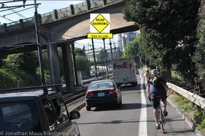
(Photo/mock-up by J. Maus/BikePortland)
The Portland Bureau of Transportation plans to use warnings signs to address a safety problem on N Interstate Avenue.
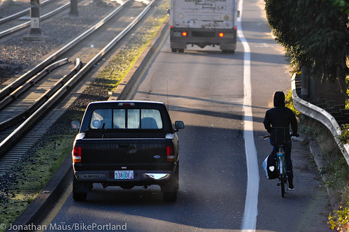
Many people who ride on Interstate — a key north-south connection between north Portland and downtown — are familiar with the extremely narrow section of bike lane where the street goes under Larrabee Ave. At a total of 16-feet wide, the two southbound lanes (one standard, one bike-only) on Interstate between Tillamook and Larrabee (at Memorial Coliseum) already feels narrow due to the presence of the MAX light rail tracks in the center median.
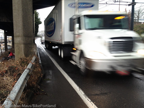
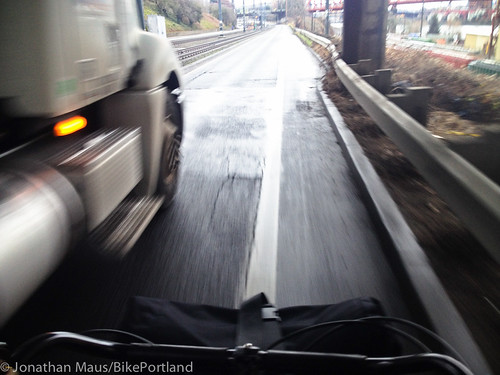
But at the Larrabee overpass there are bridge support columns that narrow the road by two feet. Unfortunately, PBOT has striped the lanes in a way that takes the entire two feet out of the bike lane, making it just 3 1/2 feet wide for a distance of 70 feet. Add a storm drain grate and frequent large truck traffic and the riding experience becomes downright scary.
Here are a few more views:
Advertisement
We raised this issue here on the Front Page back in January when we profiled the efforts of citizen activist Blake Goud. Shortly after that story, a formal request was put into PBOT (we’re unsure who exactly made the request) and one of their traffic engineers visited the site at the end of March.
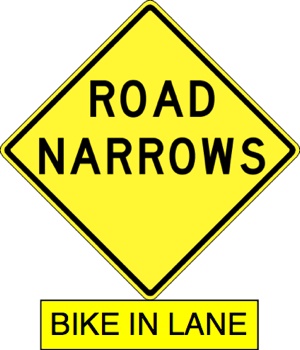
Goud recently communicated with Transportation Commissioner Steve Novick’s office about the issue and we learned PBOT decided to install warning signs after that field visit. Below is an excerpt from the follow-up report written by the PBOT engineer:
“Given the environmental constraints surrounding the pinch point in the bike lane (light rail facility, bridge columns) no viable traffic engineering solutions were deemed appropriate (other than widening the roadway which would require moving the columns) to improve conditions for cyclists on that segment of N Interstate Ave. I recommend referring the request to a CIP [capital improvement project] list for future consideration. However, in the interim, I recommend installing ROAD NARROWS sign with a BIKE IN LANE rider…”
(For what it’s worth, my personal preference was for a “DO NOT PASS” sign.)
According to a spokesperson from Novick’s office, initial work to place the signs has been completed and the Bureau of Maintenance is expected to install them soon.


Thanks for reading.
BikePortland has served this community with independent community journalism since 2005. We rely on subscriptions from readers like you to survive. Your financial support is vital in keeping this valuable resource alive and well.
Please subscribe today to strengthen and expand our work.
What is “BIKE IN LANE” supposed to mean? Seems ambiguous and confusing, not to mention probably not MUTCD compliant.
Is it a command form (i.e., meaning “RIDE IN LANE”) directed towards cyclists? In which case is it actually a regulatory sign that should have a white background? Should the bike lane go away and be replaced with sharrows?
Or is it a warning to motorists, indicating there are bikes in the main travel lane? The usual sign for this is “BIKES ON ROADWAY”
How about “SHARE THE ROAD?”
Needs to skip stripe bike lane in pinch area and add sharrows to auto lane in same.
I like the idea of sharrows there.
Share the road? Let’s replace an ambiguous sign with an even more ambiguous one!
As others have implied – WORST SIGN EVER. Even more vague than SHARE THE ROAD. Most of the auto-centric people who drive will think this is telling people on bikes to stay in their damn three-foot lane, because, for god’s sake, the real traffic needs to keep moving without delay.
Or maybe that is what it means? Who can even tell? Seems like something ODOT would peddle, more so than PBOT. I hope this is only an initial recommendation and not yet vetted.
Embarrassing.
The national uniform traffic control committee has discussed deleting the sign from the MUTCD since it is so ambiguous. The proposed alternatives include ‘BIKES MAY USE FULL LANE’.
If only there were a way to route the bike lane on the OTHER side of the bridge supports.
There is, but it costs money.
There looks to be homeless people living on the other side of the bridge support… you would be taking away their homes.
How about route the eastbound traffic onto the ramp to Broadway/Weidler and convert the eastbound lane to a 2-way cycle track Tillamook to Oregon? Aslo, do we need four lanes for autos between Oregon and Larrabee in front of the Moda Center?
route all northbound Interstate traffic onto Larrabee at the Larrabee light and it can rejoin Interstate at the Larrabee ramp… the entire .3 mile stretch of Interstate in-between can be a bike and bus lane…
It’s not northbound traffic that’s the problem, it’s the southbound lanes and all the truck traffic coming off Tillamook.
oh, right, then reverse all that… they can still take away one side of that stretch in either direction and reroute to Larrabee…
It seems like this idea would still allow for easy access to I-5 for freight coming from the Tillamook terminal area while greatly increasing at least the perception of safety (which is important) on southbound Interstate. It may even lower maintenance costs for that stretch of road in the long term since it would take less of a beating.
You have a good batting average today paikiala.
The only car trips that it would noticeably lengthen would be those taking interstate to reach the Steel Bridge. They would have to wait at two additional signals, which wouldn’t be a huge delay.
There are other more effective solutions to this long known safety problem, it is to deal with the speed of the traffic and reduce the speed differential (add more time to react to human errors/ debris avoidance and the effect of truck airflow on cyclists)…would be to add measures to physically reduce the speed of motorized vehicles…speed cushions, etc.
The long-term fix in this section will likely be part of the North Portland Greenway and I wouldn’t expect there to be a big project that improves this section outside of that work which has been ongoing for a long time (http://npgreenway.org/) and has a great group of people who have spent a long time working on this effort (note: I have talked to them about this part of N Interstate and they were receptive; don’t attribute anything from me to them). There are many more changes throughout this section (NB and SB) between Tillamook and the Memorial Coliseum that would improve the safety for people on bikes.
@paikiala I don’t think there are as many problems south of the MC that are in as immediate need of being addressed (IMO they are dwarfed by the problems further north). Agree on striping bike lane marker under Larrabee…it is not a usable bike lane on its own.
@GlowBoy I think the sign is telling people driving to expect bikes to be in the lane. The backstory to this update from PBOT was when a car honked at me and sped past me in this section after I had moved over to avoid being run down. I have requested and will request again when the sign goes up that they get enforcement here and I think they should reduce the speed limit (currently 30mph but often ignored).
AND as a frequent user of this corridor…I would strongly suggest that it is time to revisit the design changes (compromises) in the Interstate Corridor that removed bike lanes late in the process…its been ~12 years since this project was completed.
This is necessary since the state of practice / tool box has evolved AND there are selections of parking that are under-utilized now with LRT access (or off street parking supply is adequate) versus need for traffic safety. Plus there are more cyclists depending on it.
At a minimum the following blocks need to have bike lanes and intersection improvements added back in…
Southbound segments (with general landmark) are:
– 8300 block (Disjecta)
– 6400 block (Nite Hawk Lounge)
– 6000 to 6100 blocks (Interstate Lanes)
– 5100 block (76 gas station)
Northbound:
– 6000 to 6100 blocks (Interstate Lanes)
Todd —
Have you sent in requests to safe@portlandoregon.gov about these other problem points on Interstate?
If not, I’d suggest one email per location. Preferably with a photo, and a couple sentences explaining why it is dangerous and what you’d like to see as an improvement.
Most spot improvements are done on a complaint-based prioritization basis. If nobody complains [in writing, through the correct channels], then nothing gets improved.
Ted Buehler
Can’t something be designed so that the sunken storm grate is at grade, non-skid, but still permeable (for this piece of road and elsewhere)?
This is a problem all the way down Interstate on the SB side. Lots of bad grates.
this seems to make ORS 814.420 (Failure to use bicycle lane or path) useless… the city says that the process leading up to the installation of bike lanes is the “public hearing” needed to require people to bike in the bike lane…
now here we have “another” review that shows the bike lane is indeed not safe…
so it stands to reason that the process leading up to the installation of the lane is not an adequate “public hearing” to determine the lane’s safety…
therefore we’re back to needing an actual public hearing in order to be forced to use a specific bike lane… and I think I remember a previous article stating that the city could find no such meetings had ever happened…
so if the city puts that sign up then they’re invalidated ORS 814.420 for every bike lane in the city…
I appreciate this sign. Our cargo bike will not fit in the tiny bike lane and this is an inexpensive and valuable improvement. Thank you
I agree–the wording is unclear.
Is it telling people on bikes to ride in the traffic lane?
Is there a (missing) flasher that is supposed to flash when a person is riding a bike is present? It does look sort of like those signs on some tunnels.
I agree–there would seem to be many additional (and cheap and much more reliably effective) safety enhancements that could be provided short of moving the columns.
Skip the sign. Instead of narrowing the bike lane (as it is now), narrow the motor vehicle lane and put jersey barriers between the two. I’ll bet that causes motor vehicle traffic to slow down! How’s that for a cost-effective solution?
I’m with you except for the jersey barrier. That would take up 18″ or so of very valuable real estate.
I am wondering if a cyclist has ever been injured by a car through this section. If it is a safety problem I would think there is accident data to support that.
If we’re waiting for serious injury or death, if that’s a necessary part of making a decision to do something, who’s up next?
I have been working on getting them to focus on this section for about 10 months (I’ve been riding this section for 5-6 years) to try to get them to act BEFORE the serious injury/death, in contrast to the SB Greeley/Interstate intersection where it was only after there was a a death followed by a serious injury in the span of a week or two where something was done.
Interstate is not Clinton St. It is a busy road with lots of infrastructure. My feeling is if you feel unsafe passing along that stretch then take the fly-over up to Broadway, cross over at the light, and back down to Interstate.
If you have been riding that road for 5 or 6 years than I am guessing you do not think it is life threatening.
I do not think it is ODOT’s/PBOT’s responsibility to maximize safety for bicycles on every street, no matter the cost. If sharrows, paint, sighs will make you FEEL safer than great, they are low cost. But suggesting major reconstruction of a facility that has been in existence for 10 years or so without incident, because people FEEL unsafe, to me, is not a wise use of limited resources.
No Interstate is not Clinton, it is a much more important link between N Portland and vast stretches of Downtown and SE Portland that are not adequately served by other routes. And the route over Larrabee is not likely to be used as an alternative. You can hope and wish people will make this an alternative, but it won’t make it happen because it is a longer route (2 lights) and involves going uphill both ways (NB and SB) with 1.5% grade SB and 2.8% NB. People, whether they travel on foot, on bike or in a car use a route that is the most direct and won’t use an alternative route if it is longer and more inconvenient. The alignment was changed with the installation of the MAX and the bike facilities were neglected (but not entirely removed). The city needs to make them safe, just as they do with other bike lanes, and should prioritize it based on the risk, not the idea that people should just find a different way to go.
Ted,
This is a demonstrably unsafe piece of infrastructure: with zero warning, the motor vehicle lane narrows to less than 11′ and the bike lane narrows to less than 3′. Both lanes are confined by large concrete curbs plus a steel guardrail and concrete column- there is nowhere to go! Frequently large trucks (wider than 11′), city buses, and over-sized bikes (cargo bikes, trailers, etc) use this route. Moreover, Interstate is the route for most of North Portland to access NW, SE, or SW Portland. There may have not been accidents yet, but there have been many close calls, and there are many anecdotes of people not biking BECAUSE of this exact problem.
Fixing a known problem (significantly below all city standards, dangerous mixing of vehicles) before someone gets hurt or injured is a “wise use of limited resources” by any standard.
In the last photo it looks like the W-section guard rail is taking up almost a foot of space itself (Guardrail plus spacer blocks). End it at the columns (taper down to flat to meet the columns) with short sections between columns. A temporary fix until the stacked concrete block retaining wall can be built to route the bike lane behind the columns.
@Zaphod I hope there will be a better solution down the road to provide a full sized (6’+) bike lane for this route, possibly a separated path.
@J_R I don’t think they can narrow the lane by that much, but they do need to dramatically lower speeds so that people on bikes can use the lane without having to worry about being run down in the process.
@Doug I agree, that would be a good way to expand the bike lane but don’t know the possibilities of whether they could do that.
@Ted Previous complaints about this section were passed off as “nothing can be done because of the columns and road widening is infeasible and crash rates are low. I think the comment from Jonathan on Clinton St. today address the limitations on using reported crash data to judge safety.
@Many-People: I think the signs are pretty clear “Bikes in Lane” = Bikes take the lane. It is perfectly clear and I think is explicitly providing safe harbor from citation under the law for not riding in the bike lane (this was raised earlier by Spiffy regarding ORS 814.420) because section 3(c) provides an exception to the rule for people using the lane for “Avoiding debris or other hazardous conditions”. I raised this specific issue when explaining why I was in the lane when harassed by a motorist and received no response suggesting my reliance was wrong. (See: http://bikeportland.org/resources/bicyclelaws#814430)
“It is perfectly clear”
it’s obviously not perfectly clear…
There is no liability issue caused by bad road design which can not be addressed with more signs and/or street markings.
Why not use the “Bikes in Roadway” language, as in the construction sign? Seems less ambiguous.
Even striping the bike lane green under the bridge would alert drivers to the narrowing. It would become quite obvious.
Ive been passed by those double trailer dump trucks under there, and that is pretty nerve wracking.
@Curt, I agree, I have also heard the suggestion of rumble strips across the road in advance of the narrow section (but ending with enough space for people to take the lane) as another way to alert drivers.
Glad to see some basic signage going in.
I think it’s a very good idea to have it overhead. And a somewhat nonstandard sign. It almost looks 1960s-ish, like the built infrastructure around it. This will catch drivers’ attention in a more aggressive manner than having a couple “bike lane ends” signs, “share the road” signs, etc.
Nice work, Blake, PBOT, and anyone who has send in complaints about this spot to get it marched up the priority queue.
And, now that they’ve actually admitted that there is a physical constraint there, and that it is unsafe, there is a basis for moving forward to build a cycletrack bypass around the outside of that column, or do any of the other dozen or so other modifications people have proposed.
Ted Buehler
Actually, looking at the images on my PC instead of iPhone, I don’t like what I see.
1) No image of a bicycle.
2) The “BIKE” text is small and can’t be seen very far away (text has a less distinct visual appearance than a bike symbol).
3) The “ROAD NARROWS” sign is designed to be used *upstream* from the constriction, not at the constriction itself.
See MUTCD Section 2C.19
“ROAD NARROWS sign W5-1
“… should be used in advance of a transition in two-lane roads where the pavement width is reduced abruptly to a width such that two vehicles traveling in opposite directions cannot simultaneously travel through the narrow portion of the roadway without reducing speed.”
Hence, this signage doesn’t really address the issue of letting motorized vehicle operators know they need to be prepared to pass through this constriction at the speed of a bicycle, should a bicycle be in the lane ahead of them.
This is why light rail is NOT needed. Bus = cost vs. benefit.
Putting this sign in without sharrows on the roadway – starting *before* the cyclist needs to take the lane – will do nothing. There’s a sign exactly like this on my daily ride where two legacy lots prevent the city from having a contiguous bike lane (hello St. Mary’s in Beaverton…). It says “Bikes in Lane” and has a very clear picture of a bicycle rider in the middle of the lane. (There are two lanes, and the speed limit is 30 MPH).
There are two problems: 1) signs just don’t really work – they blend into the scenery, and 2) the placement of the sign should be *before* the driver will see the bicyclist and focus attention on them. You can’t really blame the driver for not seeing the sign when they’re busy watching the bicyclist in the middle of the road.
This placement problem we’ve also seen with sharrows in many places. Because there’s such a variation in speed with bicyclists, drivers should be warned of anything outside the norm *before* it occurs, not above or beside it.
I agree and I hope that PBOT will do this. In their email to me, they did not specify the placement as indicated in the mock-up included in the post and the request that prompted them to look at the location stated: “The request was to add warning signage or pavement markings for N Interstate Ave southbound approaching the N Larrabee Ave over crossing.”
thanks Blake!
I also recommend “Bikes on Roadway” for the sign. Also useful would be a lowered speed limit for that section of roadway with signage.
I was riding down there the other day and thought the same thing. Why not move the guard rail and curb so they are flush? Looks straightforward to do. You’re still pinned, but you have a little more room to maneuver. The real solution is to upgrade the crossing so the piers allow wider/more lanes on Interstate. This part of the city has grown up a lot since the crossing went in, why not admit it and do something decent?