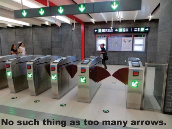
How easy is Portland’s transportation system to use, really?
It’s hard to imagine it getting a good review from anybody who’s tried to ride a bicycle to or from its biggest suburb, for example.
But the notorious labyrinth of bike paths to Vancouver aside, there are a lot of issues with our navigation system. What are we supposed to call all the neighborhood greenways that jump from one street to another? Wouldn’t it be great if street signs pointed to the bike-accessible beaches of Swan Island, the same way road signs point to the car-accessible beaches of Tillamook County? And how the heck are we supposed to keep the CL Streetcar and the NS Streetcar straight from each other?
In a rapid-fire slideshow presented during Monday’s wonky afterparty for the Oregon Active Transportation Summit, planner Rebecca Hamilton of Portland-based Lancaster Engineering drew some transportation usability lessons from a recent residence in China. Though the show is mostly visual, it’s fairly easy to get her ideas.
Related: a comment from reader El Biciclero, posted beneath this week’s post about transportation obstacles for local teens.
“Route finding,” the commenter wrote. “That this is even something that needs to be taught is a shameful indictment of the state of transportation equity. It makes bicyclists out to be a mouse in a shopping mall.”


Thanks for reading.
BikePortland has served this community with independent community journalism since 2005. We rely on subscriptions from readers like you to survive. Your financial support is vital in keeping this valuable resource alive and well.
Please subscribe today to strengthen and expand our work.
Let’s not forget there are at least TWO ways to get up here from Portland. You can try the crappy way via the I-5 bridge, or you can take the easy to use 1-205 .
Not at least. Only 2. Not counting swimming or a canoe or Amtrak. 205 does you no good if you live more west in Portland than east and your destination is more west than east once in Vancouver. Come on. Also, I’ll take the much shorter I-5 bridge over the long slog in the middle of 8 screaming lanes on 205 any day.
Yes…they both have their warts…its just depends on where you need to go…as you can not really take a detour across one to avoid the other … like the MAX security guards (and ODOT) once suggested to us to do back in the dark old bike days of the early “Otts” (aka 2000’s) when a detour plan was set up.
Do we *really* need MAX stops every ~2 blocks downtown for the E/W lines?
Cut out Old town, Oak, Pioneer Mall, Galleria, and King’s hill and you’ve probably saved 10-15 minutes worth of commute time through downtown. It’s frequently faster to walk between these stops.
Indy, I’ve been saying the same thing for years. And we could probably get rid of one stop between the Rose Garden and Lloyd Center too.
This “problem” is not unusual in our Nation and can be chalked up to 3 points:
1) managers/ DPW staff of small and mid sized cities rarely ever try to imagine their community through the eyes of a visitor [or active transportation mode user] and thus way find sign accordingly nor do they remember what they see technically/ per best practices when they travel (their work minds are often turned off during my debriefing of them);
2) bicyclists and pedestrians are “hybrid” modes in their minds and thus are abandoned to their own devices when the “easy” route cannot be fixed by staff engineers, such as ‘oh no, there is no [extra] room for a bike lane here at this critical intersection so now bikes will just merge or made due on the sidewalk’, etc; and
3) lack of transportation equity/ rapidly evolving facility tools for bicycles also makes tough for “jack of all trade” DPW practitioners, who work on roads, water, sewage, etc. to know what to do and to know how much it takes to proactively do it right vs. wrong for active transportation.
A fun factoid…the Beijing Subway has come a long way from when I first rode it in 1986…back then the line (now the #2 Line or the “Loop Line”) just when in a big circle AND they turned off the lights between stops! I assumed it was to save money on power…but I never asked. It made for a surreal ride though in the days before cell phones/ PDAs with lights.
This just shows how far a community can go in a generation when they decide on the path for policy and project funding.
http://www.nycsubway.org/wiki/Beijing,_China?iframe=true&width=100%2525&height=100%2525
’86… that wasn’t too long after Nixon’s big visit was it? Were you able to get a Nixon as Mao T-shirt?
Yep…this was back BEFORE every Chinese adult had a bicycle. They were still rationed ($50) and so most everyone in Shanghai were I lived took the bus or walked.
To be fair, the current Chinese federal transpo policy is “big everything”. Which happens to include big boulevards, big highways, big block sizes, big subway, big trains, big ‘bike’ (scooter, in the last 5 yrs) lanes, lots of buses (sitting in miles of car traffic) etc….It’s not exactly a shining example of well rationalized urban design. A few cities have slightly different transportation expenditure ratios, but the ‘big everything’ plan can be found in cities from the size of Beijing to towns the size of Eugene.
Great comments Todd. Jonathan, get this guy a guest post. 🙂
Just a small comment about the turnstyles pictured: I’ve ridden subways in China and in Tokyo, and they have virtually the same turnstyle hardware, but the operation is fundamentally different. The Chinese gates, like just about all American systems, are normally closed, and open when you insert the right fare or have your pass detected. The Japanese ones, on the other hand, stay open always, except when someone walks through without the correct fare; then they quickly close in front of the person. In an orderly society where people don’t try to cheat the system that often, you’ll never see the gates go down all day, and it has a positive effect on the mood of the commuters.
The Yanks and Chinese are similar in that sense…thus tourism planners are openly calling current generation of Chinese tourists the “Ugly Americans” of mass tourism today. Each society developing wealth seems to trigger this comment in their first taste of mass tourism…I guess the Egyptians complained about the Romans too.
So us Americans are the reference standard for oblivious, obnoxious and obtuse tourists?
I’m feeling a stirring of national pride… no wait, it passed. I drank my soda too fast.