(Photos by Dan Kaufman)
This is a guest post written by Dan Kaufman. It first appeared on his website, CrankMyChain.com.
“I was determined to attend that meeting at the coast. And I decided I wanted to bike there from Portland.”
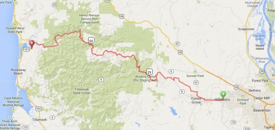
The idea of building a statewide multi-user trail network has been a passion of mine for the last several years. Along these lines, I have been promoting the vision of an Oregon Coast Pathway since 2010. This interest naturally led me to the Salmonberry Corridor trail, a project in the preliminary planning phase, which would connect Banks to Tillamook via the Oregon Coast Range. After attending my first meeting last fall, I have been following the project closely and was determined to attend the latest public meeting last Friday in Wheeler as a representative of the Northwest Trail Alliance.
Now, in the children’s story, If You Give a Mouse a Cookie, we learn that sometimes a simple action can lead to a complex chain of events…
If a hungry little mouse shows up on your doorstep, you might want to give him a cookie. And if you give him a cookie, he’ll ask for a glass of milk. He’ll want to look in a mirror to make sure he doesn’t have a milk mustache, and then he’ll ask for a pair of scissors to give himself a trim…
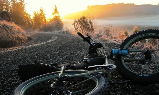
In my case, you might say the cookie was a salmonberry. I was determined to attend that meeting at the coast. And I decided I wanted to bike there from Portland. And since I was biking there, I decided I should travel as near to the corridor as possible. And since I was going to be biking out there in the wilderness, I figured I ought to take a friend with some experience. So I hit up my good friend, bike shop owner, and endurance racer, Nathan Jones, to join me. And since Jones has started renting Fat Bikes, we figured it might be a good idea to do some gear testing on a long ride that would tackle many road surfaces. So, if you give a mouse a cookie-of-a-meeting in Wheeler, Oregon. It could turn into fat bike demo and adventure in the Coast Range.
The 70 attendees at the Salmonberry Corridor Coalition Meeting represented a variety of agencies, organizations, and interests. The meeting was led by Rocky Houston the State Trails Coordinator for Oregon Parks. Many coastal residents and community leaders turned out to show their support for the project. A large contingent from The Oregon Coast Scenic Railroad also came to have their right-of-way concerns addressed. OCSR representatives assured coalition supporters of their strong support for a rail with trail project in the currently operating coastal and Nehalem river sections.
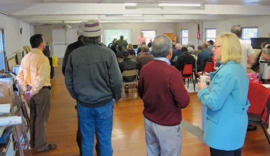
Many coastal leaders and residents attending would like to see this project start right away for a variety of reasons, including their desire to see a safer route for the many bicyclists who use Coast Highway 101. There were also some community concerns, including the possible use of chemicals to deal with foliage along the pathway, which could be harmful to people with sensitivities and those who want to pick edible berries nearby.
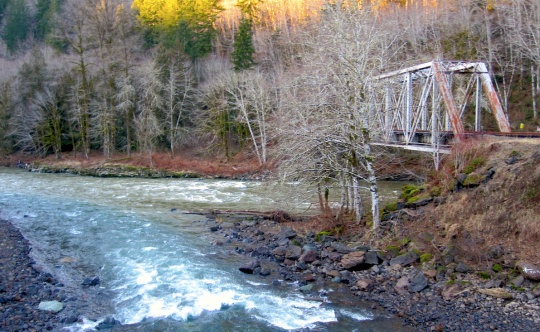
Jones, always up for an adventure, briefly promoted the idea of riding fat bikes along the Salmonberry section. Luckily, I recalled a story about a couple of guys who had taken fat bikes in there and found it rough going. An internet search turned up their story in this brief article by Herb Belrose and his longer article “Riding the Burn Cycle” on issuu.com. It sounded like an amazing, if harrowing, adventure and probably one best done with hiking boots. Nature has proven who really owns the right of way in the Salmonberry especially since the massive flooding and wash outs of ‘07. The area is reverting back to its natural, rugged state.
That settled it, we were going to stick to the logging road path that Nathan had originally routed for us over the Coast Range. We figured fat bikes with knobbies were overkill for this gravel and paved route.
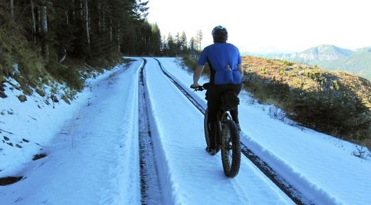
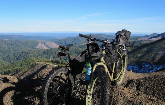
But we wanted to see how fat bikes fared on these surfaces over a long distance especially since Jones is now renting these glorified mountain bikes through his shop, Ride Yr Bike. We knew we faced some extremely steep climbs and radical descents. We didn’t figure there would be snow in some places above 3000’ or gravel sections where much of the rock was about the size of a child’s fist.
Much of our ride was spent going up hills and then ridge riding, by permission, through big sections of private timberland and the Tillamook Forest. We had to keep a close look out on our GPS so as not to take one of the many unmarked wrong turns. The tracking devices saved our bacon a couple times but in one instance the road mapped did not exist. We just happened along a forest service worker, the first car we had seen for hours, he had been searching for the same road and had determined based on maps that it did not exist. It was pure luck that saved us quite a bit of time and taught me an important lesson about carrying a real-life map for backup.
The weather was sunny and clear and we were able to spot five peaks in the Cascades from Mt. Jefferson to Mt. Rainier. Clearcuts and logging roads allowed these panoramas not possible in roadless wooded areas. This type of lumber extraction creates a patchwork of bare land, freshly planted trees, and young stands of timber — and gave this third generation Oregonian (who once worked in sawmills) lots to think about as I grinded my way toward the Pacific Ocean.
Of course, one of the main community drivers behind the Salmonberry Trail is the promise of economic development in a region that once had much more sawmill and other forestry related business and jobs. The Banks-Vernonia rail trail, which now sees 250,000 users a year, coupled with Stub Stewart State Park together have brought visitors into the nearby communities and have opened up new opportunities for tourism related business. But even the most primit
ive trails require maintenance. How can this trail system make sure it has the ongoing maintenance it needs? One idea I proposed on behalf of the Northwest Trail Alliance was to utilize the trail cycling club to help build and maintain natural surface sections, especially in the wilderness areas that may never be feasible to be paved. NWTA has already helped build a mountain bike network at Stub Stewart and has demonstrated many other successful trail building projects in our region. This kind of partnership could help reduce cost and connect community and users.
The Tillamook Forest Heritage Trust, the organization responsible for building the multimillion dollar Tillamook Forest Center, is interested in taking the lead non-profit partnership role in developing the Salmonberry Trail because it aligns with the Trust’s mission of “developing tools and experiences that help Oregonians better understand and appreciate the Tillamook State Forest and all of Oregon’s State-owned forests.” The Oregon Coast Scenic Railway also offered their building equipment and access to tons of gravel to help with the build.
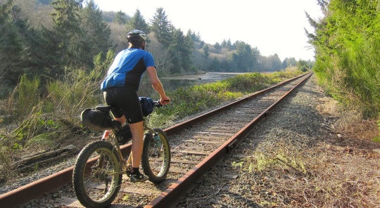
To get a sense of the coastal section of the pathway, Jones and I decided to fat-bike it towards Tillamook on the railroad tracks after the coalition meeting. It was a sun-drenched, car-free, and train-free path (the OCSR only runs during the summer and on other special occasions the rest of the year). This stretch of coast that starts in Wheeler and runs through the towns of Rockaway, Garibaldi, Bay City and Tillamook, already has many points of interest and places to stay for tourists. Unfortunately, it cannot be safely or easily traveled by children, the elderly, the disabled and others. Recently two vulnerable users were killed by car drivers near Barview Jetty County Park — even riding in a car is relatively dangerous on on HWY 101. I have cycled this route three times and loved it, but riding down the tracks was just so pleasant and peaceful, except, of course, for the constant bumping of the railroad ties! (That problem was alleviated quite a bit after I dropped to the fat bike tire pressure to almost zero).
I could see a path in the coastal section being used not only by thousands of tourists but also by locals as a way to easily get from one community to another or safely to school or work. Overall, a rail/trail path from the valley to the coast is the kind of transformative project Oregon needs for community health, transportation and tourism. “Giving ourselves a Salmonberry” will likely lead us down a long, complicated set of twists and turns before completion. I can tell already (from the people I’ve spent time with to the places I’ve seen) that getting there will be half the fun.
— Read our past coverage of the Salmonberry Corridor Trail project.


Thanks for reading.
BikePortland has served this community with independent community journalism since 2005. We rely on subscriptions from readers like you to survive. Your financial support is vital in keeping this valuable resource alive and well.
Please subscribe today to strengthen and expand our work.
All in all it was an amazing ride, fat bikes were perfect for the route, pretty freaking amazing. That said it would be nice to have a flat corridor to the coast, can’t wait to see the Salmonberry come to fruition!
Wordplay!! That route would so quickly become nationally renowned. I wouldn’t be shocked if Portland became the launch point for a ton of West coast bike tours, instead of Vancouver or Seattle.
And in the meanwhile, there are some pretty relaxing, low-traffic bike routes to the coast. Especially #1 and #3 here:
http://www.portlandoregon.gov/transportation/article/301633
I’m fond of the route to Astoria, but adding in a gravel shortcut that gets rid of the first chunk of Nehalem highway, pretty cool. There’s one spot where it looks like the trail disappears entirely, after a little bushwhacking you can make your way through, the climbing isn’t that bad either and you get some good views of Saddle Mountain.
This is the connector.
http://ridewithgps.com/routes/3956875
Just fantastic guys!!! Thanks for getting involved with this and sharing your experience.
I really hope this trail is finished ASAP. Like before I die 🙂
How accessible are these roads now? You said that you had to get permission for some. Are there any 20ish mile sections that are doable right now?
I’m not quite sure what Dan meant by “permission”, honestly I’m nearly certain we didn’t travel through anything closed to bikes, just to cars. So yeah, the snow section is way up high, so chances are if you got the legs to make it up to it, then you’ll be able to ride through the tracks that have been cut. It’s all legit legal riding and is “fully rideable” as far as your skillset will take you. There are a few places where a touring bike would be a really rough and bad choice, actually several places. Bring a MTB or bigger even for the earlier stretches.
Sorry for not replying sooner. What I meant by “permission” was that the road was closed to most activities except the land owners had given permission for cyclists to use it (plus hikers and equestrians). Probably could have worded that better. Here is a picture of the sign at the gate: http://www.flickr.com/photos/69105289@N00/12290877835/lightbox/
“A large contingent from The Oregon Coast Scenic Railroad also came to have their right-of-way concerns addressed. OCSR representatives assured coalition supporters of their strong support for a rail with trail project”
Yeah, well, they don’t own the route, and they don’t have any right-of-way rights. If the rail needs to come out to make a trail possible and the actual owner agrees, take the rail out.
True, the Port of Tillamook owns the right of way but I am fairly certain OCSR has a multi-year lease. They are actively operating from Tillamook to the confluence of the Nehalem/Salmonberry Rivers.
It is true that it would cost more to build rail with trail (like the lower Springwater) than to just rip out the rail and build a path over it. OCSR folks (and others) would make the good argument that once you rip out the rail it’s very likely that kind right of way won’t come back, which could be a regrettable decision not just for scenic railway but for future transportation options. Personally, I would prefer to see both, if at all possible.
Their lease is very nearly over. If there are stretches where it is practical to leave the rail, I agree it should be left (it would be an unnecessary expense to remove it), but there should be no great effort to save sections of rail that are provably hopeless, and that’s why OCSR’s uncompromising position on rail removal sticks in my craw. It’s just not up to them, and their rep’s been throwing his weight around making like the group owns the joint. Sorry for the rant … groups that try to dominate the discussion to push their private agenda irk me.
MT, actually we have a 20 year lease with the Port of Tillamook Bay. Our lease is good for another 18 years. We are looking forward to working with you and other trail enthusiasts to make this rails with trail a reality. Thanks for your support.
Just out of curiosity what would be the plan if someone was injured on this path the area has very limited access. Another thing is who will foot the bill for the removal of existing track and the maintenance of the trail. How will it be accessed for someone to go and remove track and ties wouldn’t the damaged rail have to be repaired so access could be made. I think there is already a trail that can be used it’s between the rails.
I guess we accidentally ended up at the confluence of the salmonberry and Nehalem rivers on a road bike ride. The photo above leaves out the part where the rail is completely dangling at the road crossing there (but the bridge on foss road seems pretty new construction, so that has something to do with it, I bet). It’s interesting to learn that there’s so much of an effort to build up an area that we’ve been poking around a few times.