(Photo by J. Maus/BikePortland)
Reacting (in part) to the desires of more than 2,200 survey respondents, the Oregon Department of Transportation (ODOT) is poised to implement several projects in the Mt. Hood area that will improve bicycling access.
As we reported back in August, wider shoulders on Highway 26 and Highway 35 were among a list of projects being considered as part of ODOT’s Mt. Hood Multimodal Transportation Plan. Last month, that plan’s Project Leadership Group (made up of ODOT, County, and federal “decision makers”) released their project recommendations (PDF). On that list are several projects in “Group A” that will impact bicycle access.
Here they are:
- Mt. Hood Highway bike/pedestrian intersection improvements ‐‐ depending on where transit stops are located for enhanced transit service on US 26 and OR 35, there may be a lack of pedestrian or bike crossing facilities at those locations. This project would, in coordination with the community and the Oregon Department of Transportation, design safe and convenient pedestrian and bicycle crossings across US 26. The project would encourage the development of enhanced pedestrian traffic control (example could be crosswalks or signals) to facilitate movement across US 26 (Rhododendron has been identified as one likely place for an enhanced crossing).
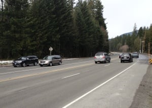
- Mt. Hood Highway shoulder widening for bicyclist use ‐‐ There are many stretches of US 26 and OR 35 where shoulders are very narrow or nonexistent. Bicyclists rely on shoulders for travel through this area. This project would create a plan prioritizing shoulder widening locations in along US 26 and OR 35 . Shoulder widening would be targeted to areas based on need and cost.
- Bike/pedestrian info along Mt. Hood Highway with maps to mountain biking, alternate routes to US 26/OR 35, hiking trails, etc. Wayfinding would be a key element. (This project is slated for completion in the “mid-term” or 3-7 years.)
- Bike intersection improvements at OR 35 and OR 282 intersection ‐‐ The bike shoulders on southbound OR 35 end through this intersection, so bicyclists have to merge into high‐speed traffic at this location. In addition, bike lanes are not striped on OR 282 as it nears OR 35, so bicyclists have to enter the lane at the intersection. This project would stipe a bike lane on OR 282 approaching OR 35 and would look for ways to widen available space on OR 35 to allow for a bike lane on OR 35 south to the west of the dedicated right‐turn lane.
- Bike intersection improvements at OR 35 and Historic Columbia River Highway (HCRH) (E. State St.) in Hood River ‐‐ This intersection lacks striping for bicyclists headed east on HCRH to OR 35 north (or across the highway to the HCRH multi‐use path). The project would add bike lane striping (green striping potentially) for bicyclists headed east from the bike lane on HCRH to the OR 35 crossing.
There are other bicycle-related projects on the list, but the ones above are in “Project Group A” which have first priority for implementation and are expected to completed in 0 – 5 years.
If you’d like to learn more and/or weigh in on these projects, the Project Leadership Group is set to meet in Portland on Thursday, December 19th from 3:00 to 4:30 pm at ODOT Region 1 headquarters (123 NW Flanders, Conference Room A/B). The public is welcome.
— Read more about the Mt. Hood Multimodal Transportation Plan in our archives.


Thanks for reading.
BikePortland has served this community with independent community journalism since 2005. We rely on subscriptions from readers like you to survive. Your financial support is vital in keeping this valuable resource alive and well.
Please subscribe today to strengthen and expand our work.
In the US we have historically seen a pretty clear distinction between bicycling for pleasure/recreation/fitness/adventure and bicycling as transportation. I wonder if ODOT’s acquiescence here hints at an institutionalized version of this distinction that goes something like this:
* people biking for recreation (Hwy 26 to Mt Hood) is cool, complements driving, (which we all know is how everyone gets around); let’s fund that.
* people biking as transportation (Barbur Blvd) is not cool, won’t get a dime from us because, well, we’re the highway dept.
Just a thought.
9watts, you may be on to something, but even so, I’m pretty happy to hear that wider shoulders are coming to 26/35. It is hairy biking up there now, and this could help a lot.
But will they plow it in the winter?
Have they considered making a MUP that runs parallel to US 26 just off the shoulder? The highway is terrible for both bikes and pedestrians in most sections. I would much rather ride on a 8′ wide MUP 5-10ft off the highway than ride in a “wide bike lane” next to 70mph traffic.
If Oregon really wants to increase safety and bicycle tourism revenue, they’d physically separate the bicycle area with zebras or a small concrete median. Zebras or regular, frequent breaks in a concrete median would still allow motorists to pull over for emergencies, and make the average cyclist tremendously more comfortable on these high-speed roads.
I’m mostly the strong and fearless type but I don’t do highway shoulders. They just aren’t fun.
I rode from happy valley to Timberline Lodge. It felt like an accomplishment for sure but I have not had the desire to do it again since that first and only time.
I live in the Hoodland area (Welches, Zigzag, Rhodie, Brightwood) and both road and mt bike. I am one of a handful of bike commuters (when daylight is better than now) via bike on Hwy 26 to Sandy. I don’t believe we will ever see funding for a seperate bike route adjacent to the highway. Putting barriers to protect the current bike lane would be reassuring but become problematic with snow removal. I would be happy with the narrow bike lane sections (like westbound near bottom of Cherryville Hill)) being widened out. The pedestrian crossings (or lack of) are scary in Govie, Rhodie, Zigzag and Brightwood Loop. Parents don’t let their kids ride to school because of the highway crossing.
We have only one alternate east-west route from Sandy to Lolo Pass Rd. It is Marmot Ridge which is longer and much hillier but wonderful. The problem is Clackamas County chipsealing. This summer they chipsealed it. Barlow Trail Rd’s smooth pavement is gone. Marmot Road was chipsealed before but they used the rougher chipseal on that this time. We fought these hard with good numbers of people involved but the county defaulted to their computer software road surface managment system. Could have used more help from BTA – we asked for help but only got one email with advise that I saw.
Are there any scenic routes that avoid highway 26? I have always wanted to ride to timberline but hate the thought of riding on the shoulder regardless of how wide it is. I don’t understand the push for wider shoulders. You could make the shoulder on I-5 wider than a country mile and it would still suck as a bike route
Mike – Like I mentioned in my post, from Sandy to Lolo Pass you can avoid Hwy 26 all together by using Marmot Rd and Old Barlow Trail Rd which will bring you to Zigzag. There are short sections between Zigzag and Kiwanis Camp Rd (Rd 2639) that will give you some relief from the highway, but if you want to stay on pavement, there is no choice from Kiwanis Camp till you get to Govie. From Govie you can take West Leg Rd instead of Timberline Rd.
If you are willing to do some gravel roads and a bit of easy trail there are a couple choices. Rd 19 to get you from Lolo to Rhodie. From Rhodie, take Rd 20 to Rd 12 which will take you up to just shy of Trillium Lake, going by Summit Meadow Cabins and Still Creek Campgroud (back on pavement) to Govie. Or to single track from Rhodie – take Pioneer Bridle Tr at Tollgate Campground up to Crosstown Trail and then Timberline To Town Trail to Timberline. I can take the bus to Timberline and single track almost all the way home in Zigzag.
The Glenn Jackson bridge is sort of a reference unit for enduring fast, loud, and voluminous traffic. My tolerance threshold is probably 1.00001 GJBs, and definitely lower than the ride to Government Camp.
I’m not BikePotland’s biggest advocate for separation, but a low-stress route that parallels US26 would definitely be preferable. This is logging trucks, four lanes of up to 70mph traffic, and hills. I can’t blame anyone for not wanting to swim with those sharks.
Consistency in the shoulder composition would be great on the way down 26 from Govy. Check out this video of my descent 2 years ago, where I had to ride the fog line for a large part of it, or risk catching a wheel on the edge or getting hit by some pretty close cars.
http://www.youtube.com/watch?v=gI5STeI6Nus#t=74